Rethinking approaches to the art of the Ancient Near East until c. 600 B.C.E.
by DR. SENTA GERMAN
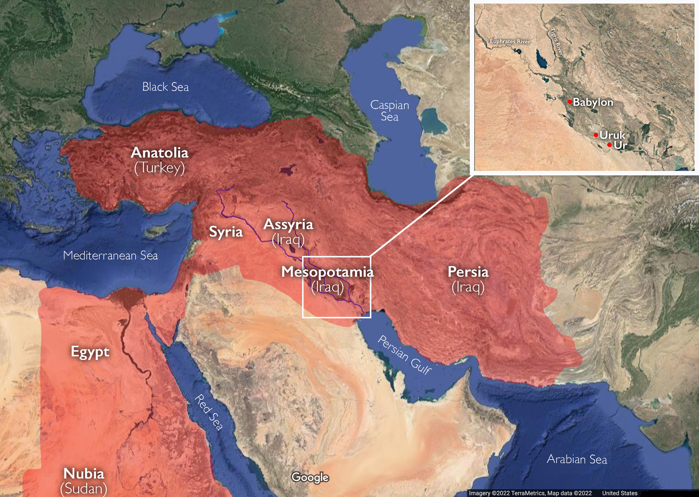
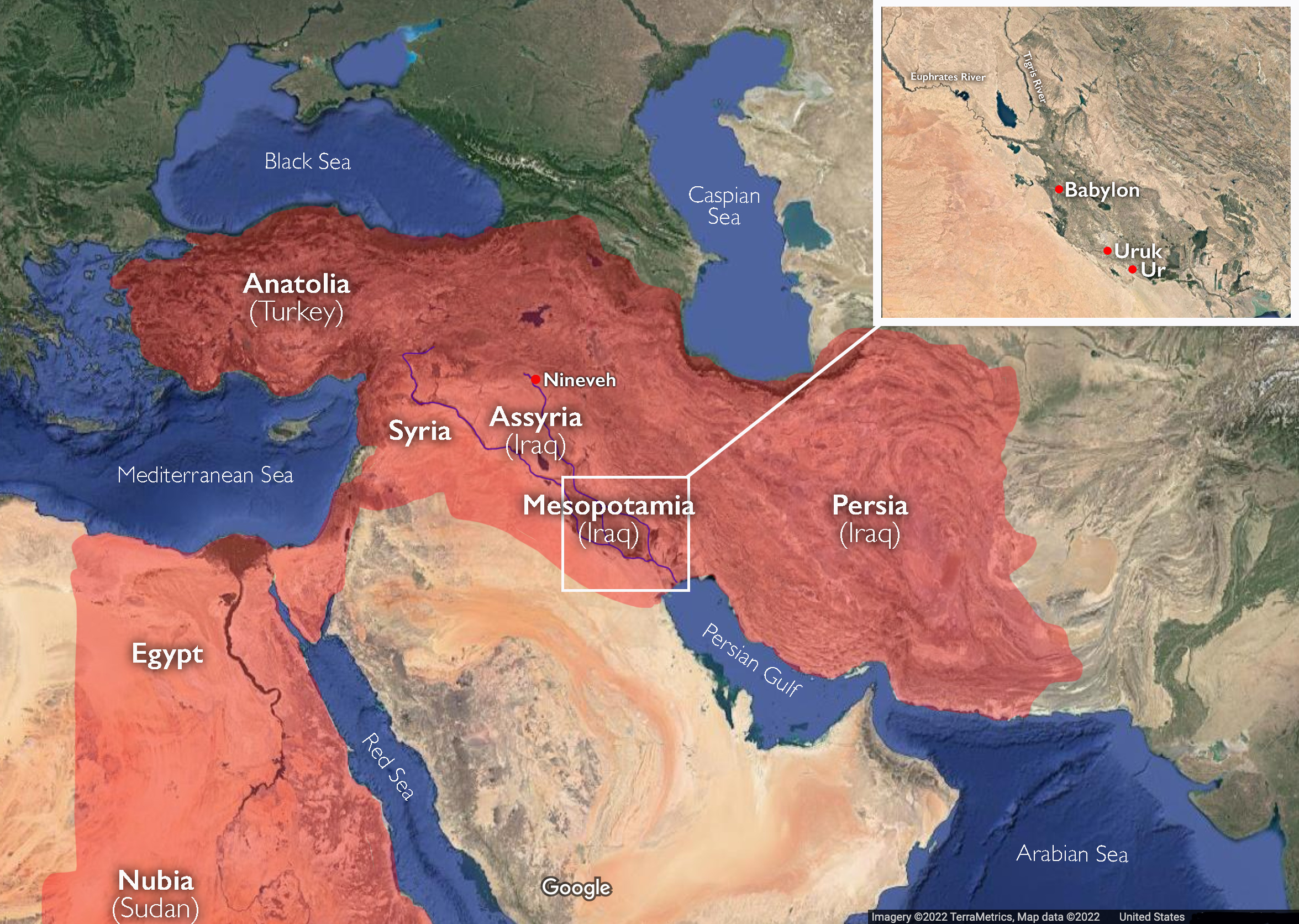
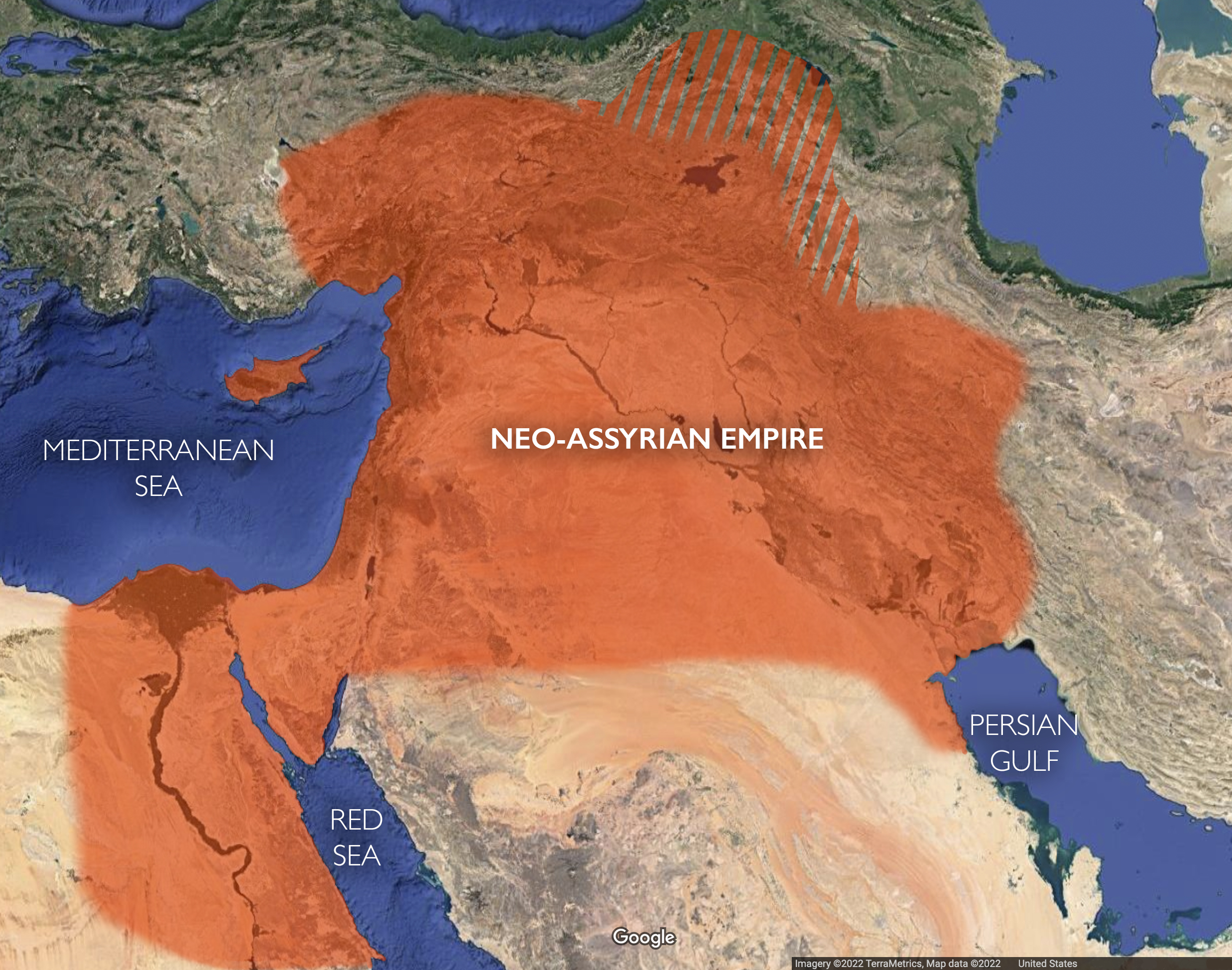
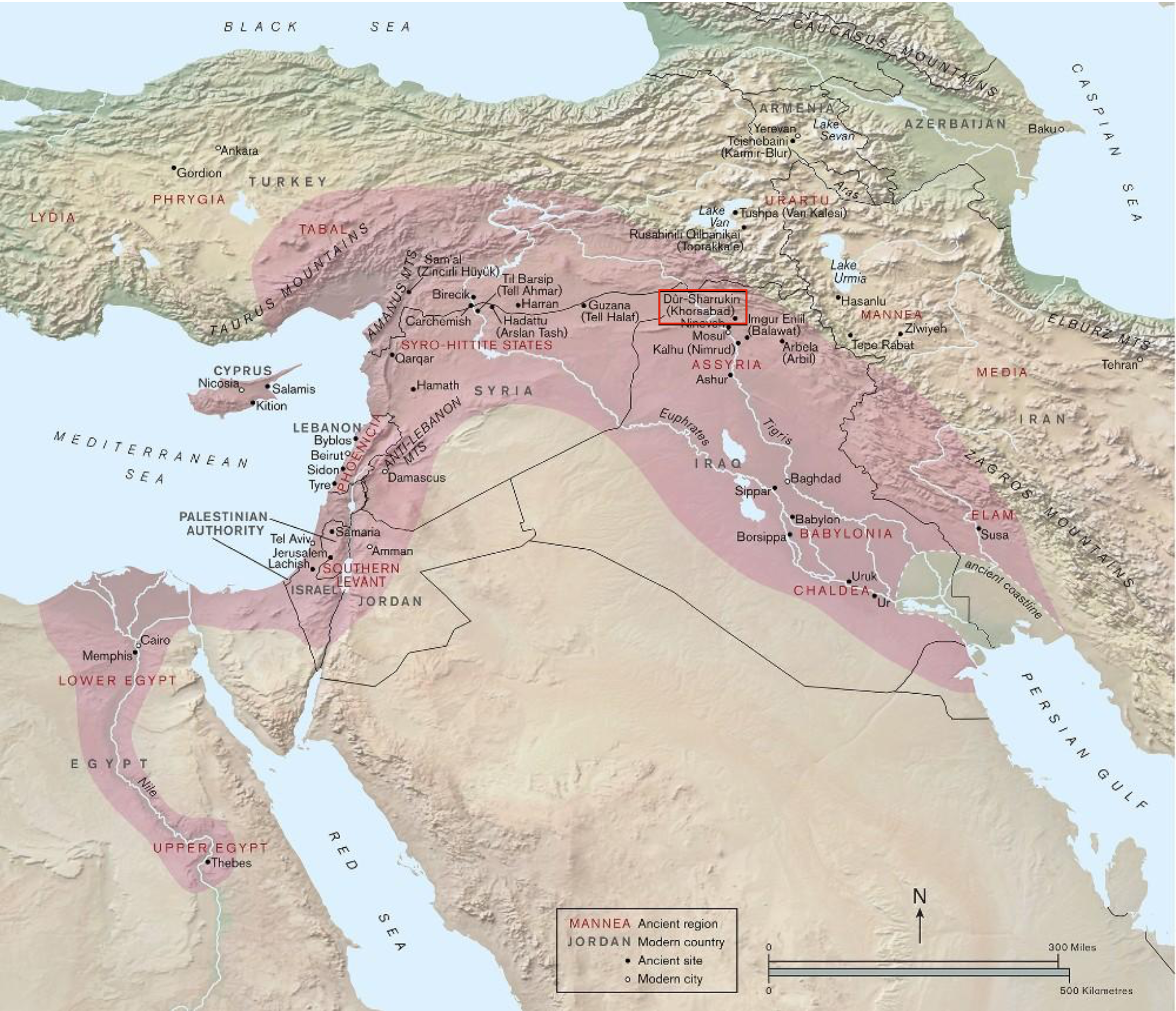
Enormous cities. Writing. Massive temples that stretched upwards to the sky. Long-distance trade. Developments that characterize the earliest states and empires of the Ancient Near East still enthrall us today. The art and architecture of the Sumerians, Babylonians, and Akkadians (from what is known as Mesopotamia, the area between the Tigris and Euphrates rivers), as well as Assyrian cultures from the 6th to the 1st millennium B.C.E. are often the focus, but these were inextricably tied to the greater region, including that of the ancient Egyptians, Canaanites, Hittites, Mitanni, and Persians (also called the Achaemenids).
All of this is called the Ancient Near East, so called “near” because it is nearer to Europe (“the West“) than East and Southeast Asia, such as China, Japan, Korea, Indonesia, and Vietnam. This label is, plainly, Eurocentric, and dates to the 18th century and the European categorization and organization of the rich eastern trade lands. We might ask whether we should still use the term “Near East,” given how embedded it is in the colonial past—when European countries, such as England, France, Belgium, and Germany held huge swaths of land on the continents of Asia and Africa in order to systematically and violently extract valuable raw materials and labor, the fruits of which flowed back to colonial owners and nations while leaving colonized lands poor and politically volatile.
If you take any introductory course on art history, the art of the Ancient Near East will often be taught at the beginning and comprise several modules. It has become an important part of the art-historical canon for many reasons, including:
The Ancient Near East is a part of the world where we find all the hallmarks of civilization—a collection of circumstances and practices, typically defined by urban living, craft specialization, a spectrum of wealth, from rich to poor, some form of government and laws or social organization, a written language, and monumental architecture.
The art of the Ancient Near East illustrates some of the earliest, grandest, and most sweeping military conquests in world history.
The history of the Ancient Near East is inextricably linked to to the stories and characters of the Bible, as well as their visual representation. Many of these stories have been a near constant subject matter of historians and art historians since the 19th century.
Many Europeans have linked their cultural heritage to the history of the Ancient Near East for centuries.
Alongside these reasons one might add that we study the art and architecture of the Ancient Near East because it is spectacularly beautiful, astonishingly sophisticated (especially for such an early era), and at the same time emotional and human. However, a lot of what we say about Ancient Near Eastern art is rooted in outdated ideas or perspectives that need to be rethought and replaced with newer questions that have only begun to be explored. Early cities, for instance, also arose in places like the Indus Valley and ancient China (among others). This chapter seeks to highlight some of these outdated perspectives and to point to new areas of study.
Architecture: Power for Gods and Men
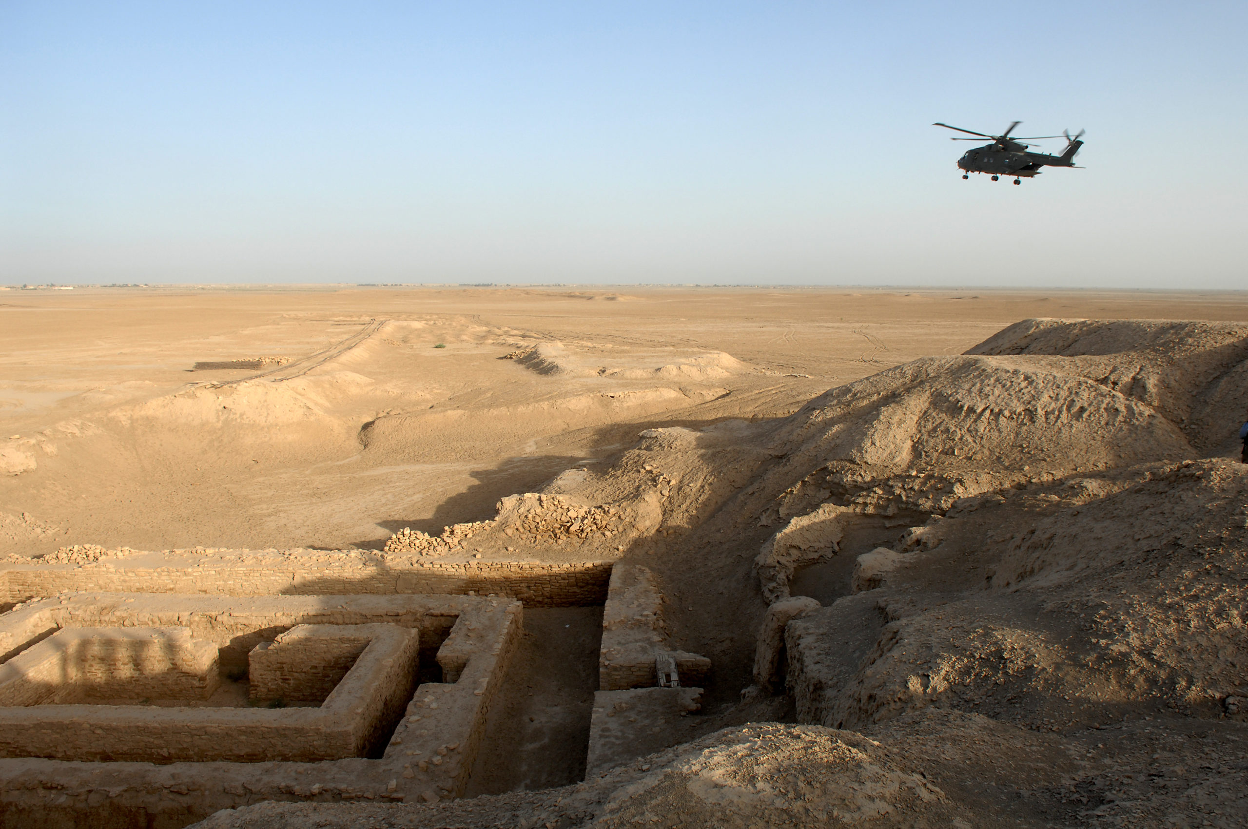
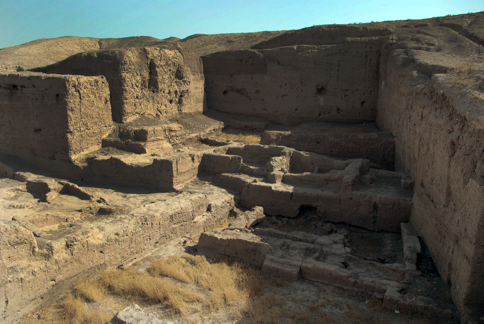
A general view of the Uruk archaeological site at Warka in Iraq
In the 4th millennium B.C.E. (c. 3200–3000 B.C.E.), Uruk in Mesopotamia was a city with a population of some 40,000 residents and another 80–90,000 working the fields in the environs. It was by far the greatest urban locus in the world at that time. The sheer power of Uruk’s agricultural wealth supported a larger population and afforded greater trade, all of which led to building on a monumental scale. Uruk was not alone; many of the city-states in the Ancient Near East had enormous buildings commissioned by the priestly class who controlled the agricultural surplus. This was a theocratic society—ruled by the priestly elite. Part of the power of this elite was their prominent representation in art. These, together with images of gods, were powerful symbols of power over vast groups of people.
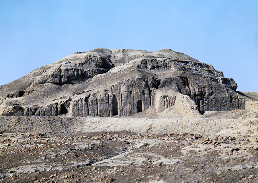
To stand atop Uruk’s Ziggurat, at such a height, would convince anyone of rulers’ and priests’ god-like powers and prestige. White Temple and its Ziggurat, c. 3500–3000 B.C.E., Sumerian, mud brick, Uruk (modern Warka, Iraq)
The architecture of the Ancient Near East is among the first in the world to aim for monumental scale. Monumental architecture works in two ways: first, as something to look at in wonder because of its massive size and how it makes the viewer feel small next to it. Second, monumental architecture is powerful human-made topography, like building your own mountain to stand on top of it. In a region like southern Mesopotamia that is flat and marshy, to erect a massive structure, reaching skyward, mountain-like, would have seemed an accomplishment only a god could ordain. An example of just such a structure is the White Temple and Ziggurat at Uruk.
Not only did the White Temple and Ziggurat rise from the surrounding plane like a human-made peak but climbing the carefully constructed stairs to the elevated plateau and looking down offered a brand new sense of geographical and human domination. Only a god and his theocratic colleagues on earth could see to the creation of something so massive and this power would have been intensely felt by those holding that high ground. As a layperson, confronting that power would be humbling.
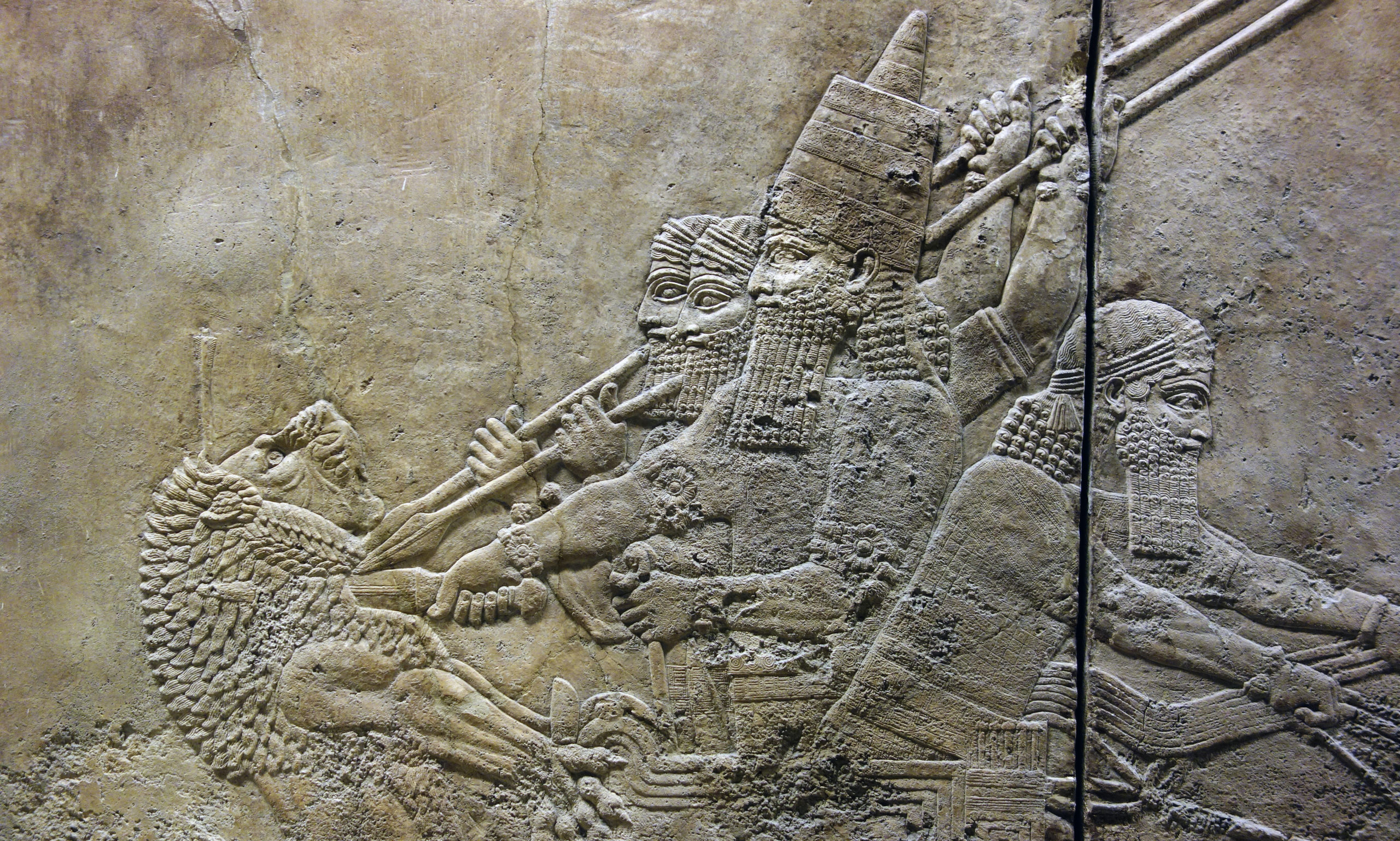
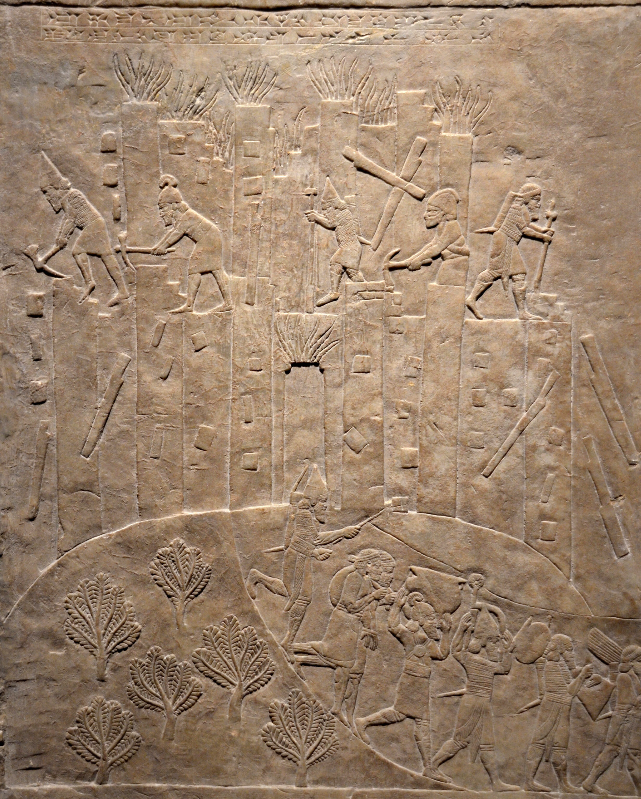
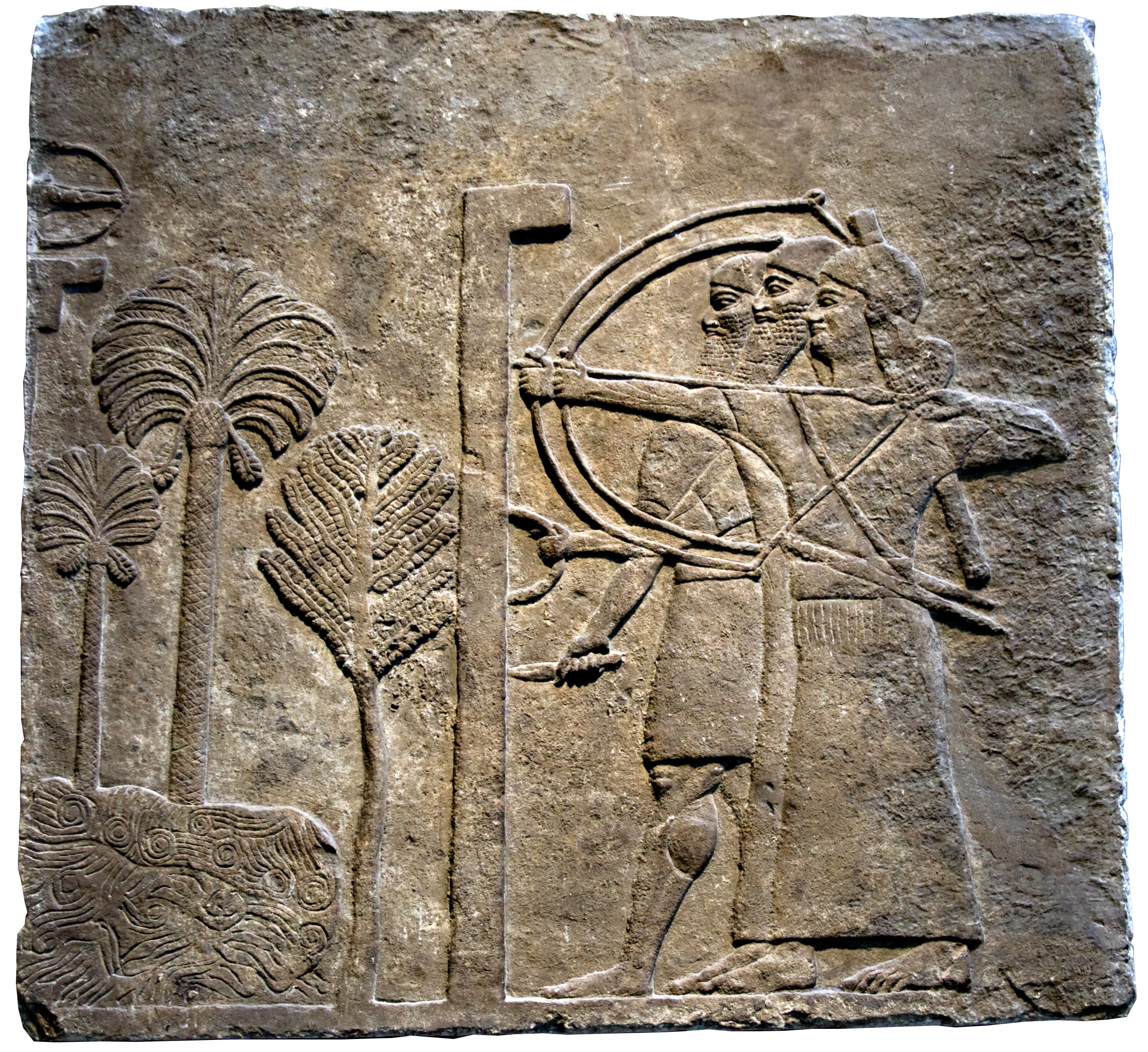
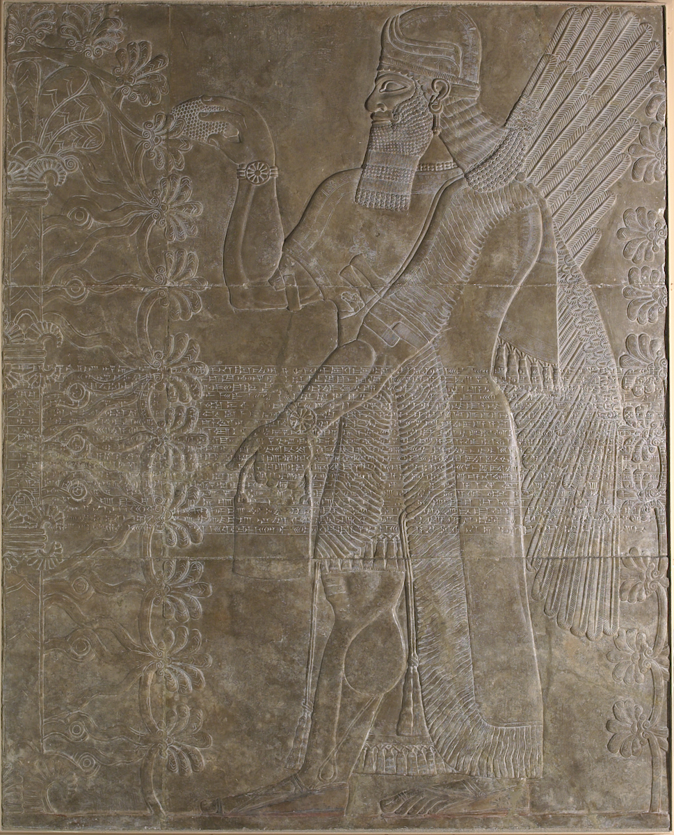
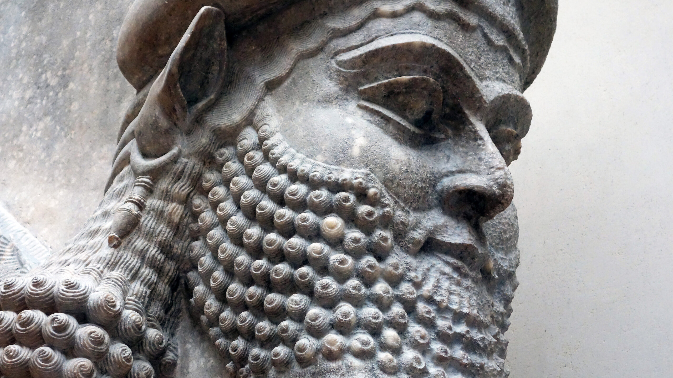
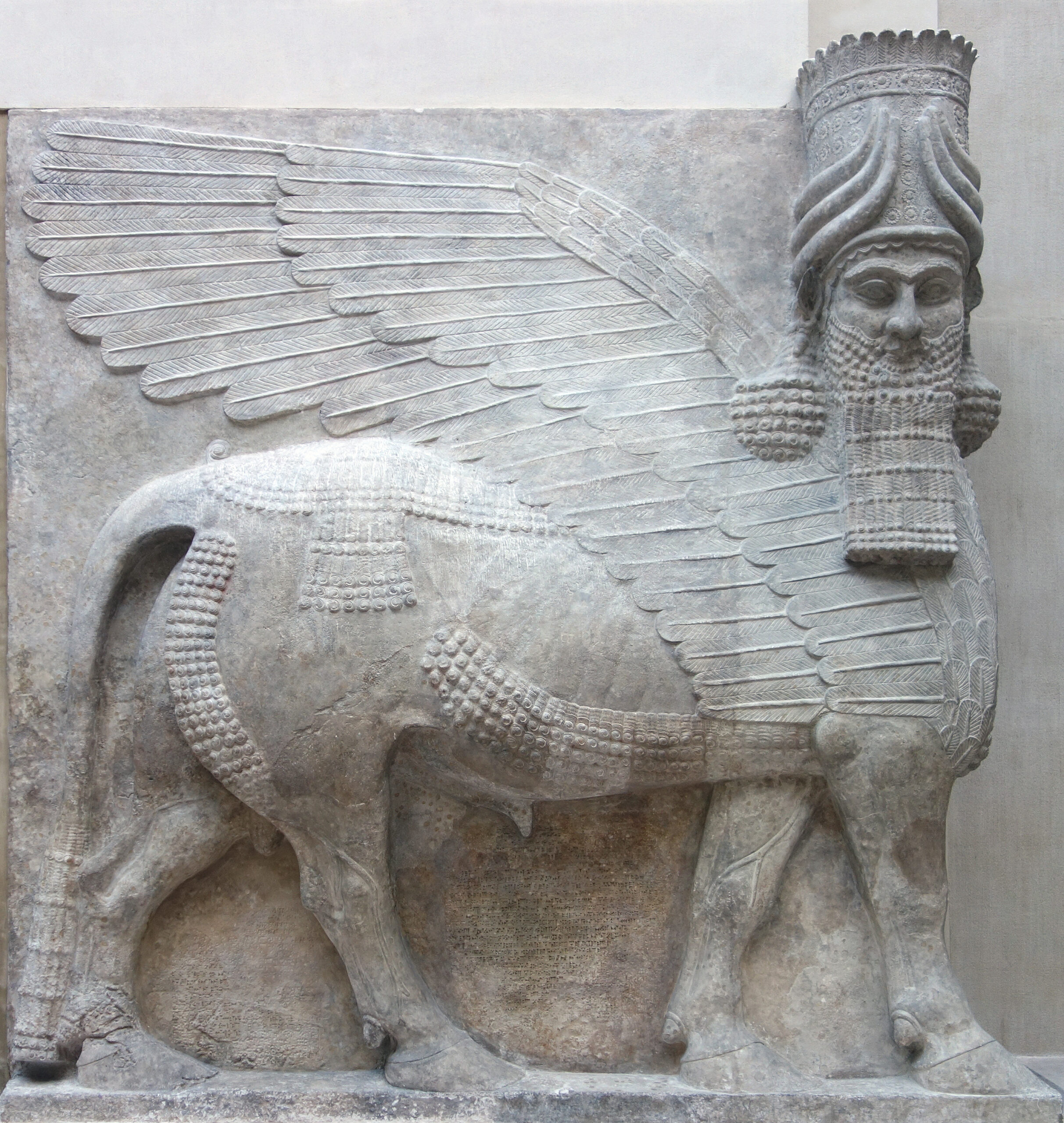
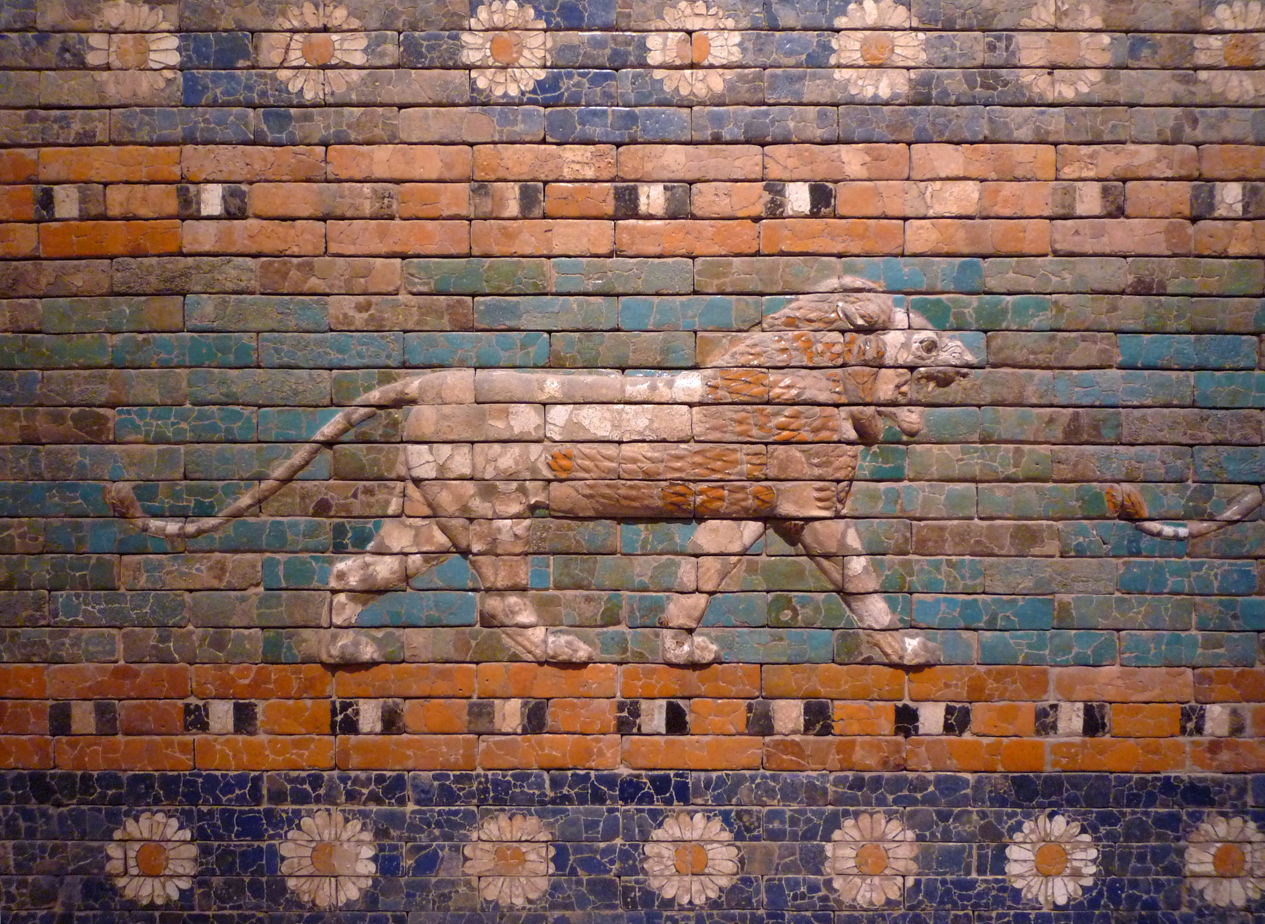
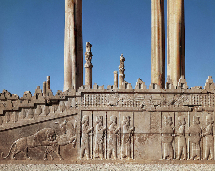
A similar kind of humbling power was employed in the interior spaces of Ancient Near Eastern elite architecture and the best example of this can be found in the well-preserved interior relief sculptures of Neo-Assyrian palaces built for rulers. The inner rooms of these structures, especially those which would be seen by visitors, were decorated with richly carved and vividly painted scenes of warfare, brutal subjugation of enemies, the extraction of resources from vanquished lands, and the erection of monumental structures. All of these scenes glorified the theocratic kings of Neo-Assyria and were intended to make visitors feel weak and vulnerable.
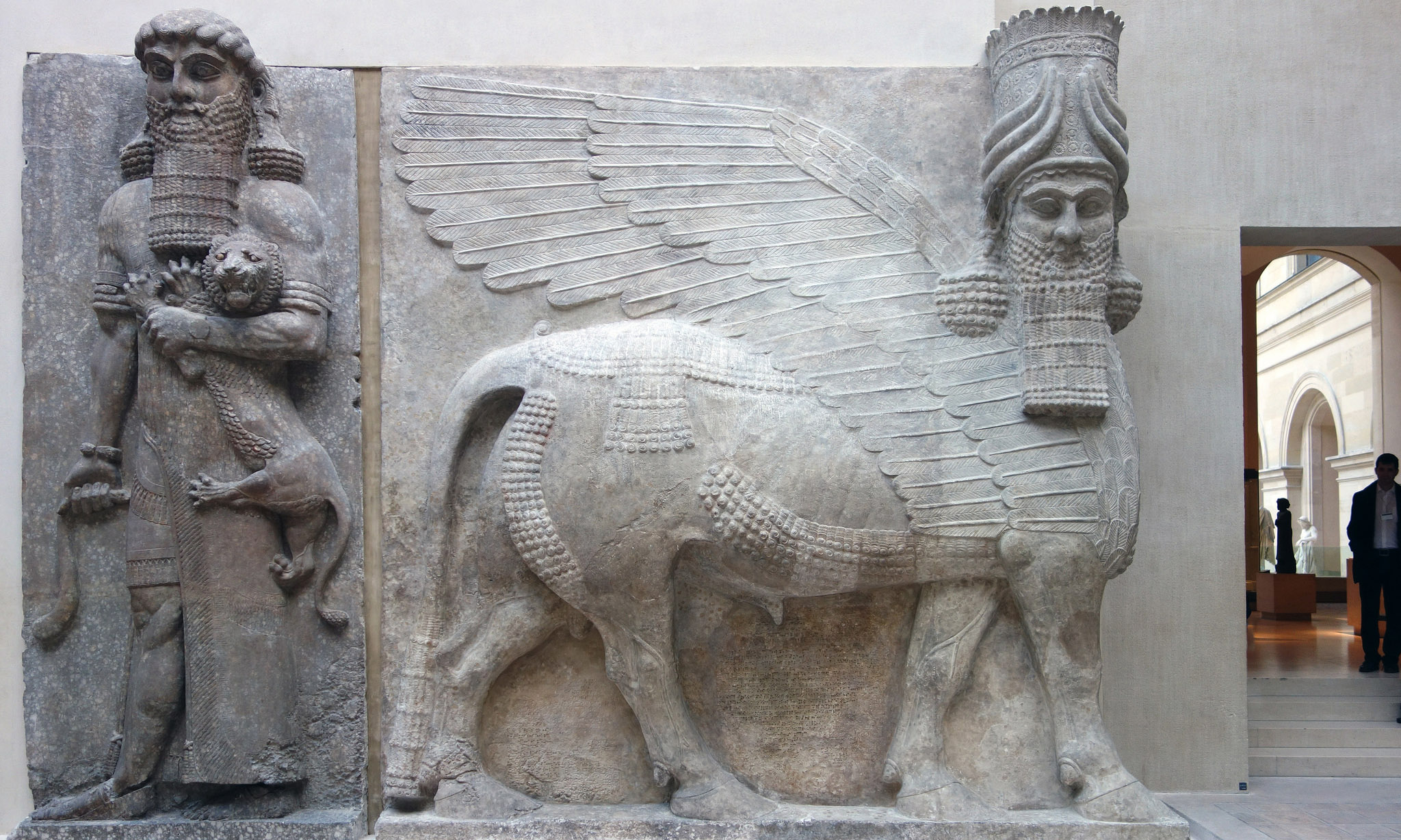
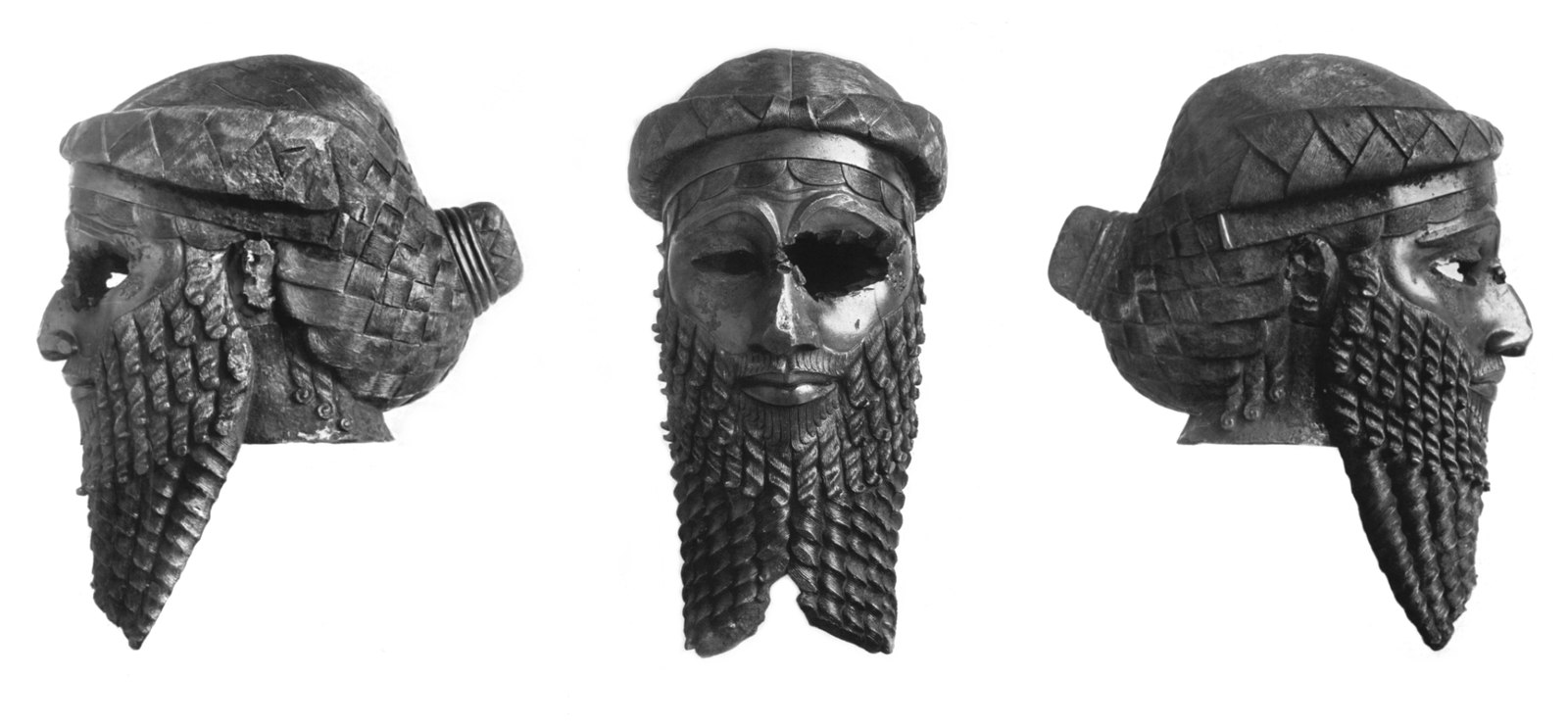
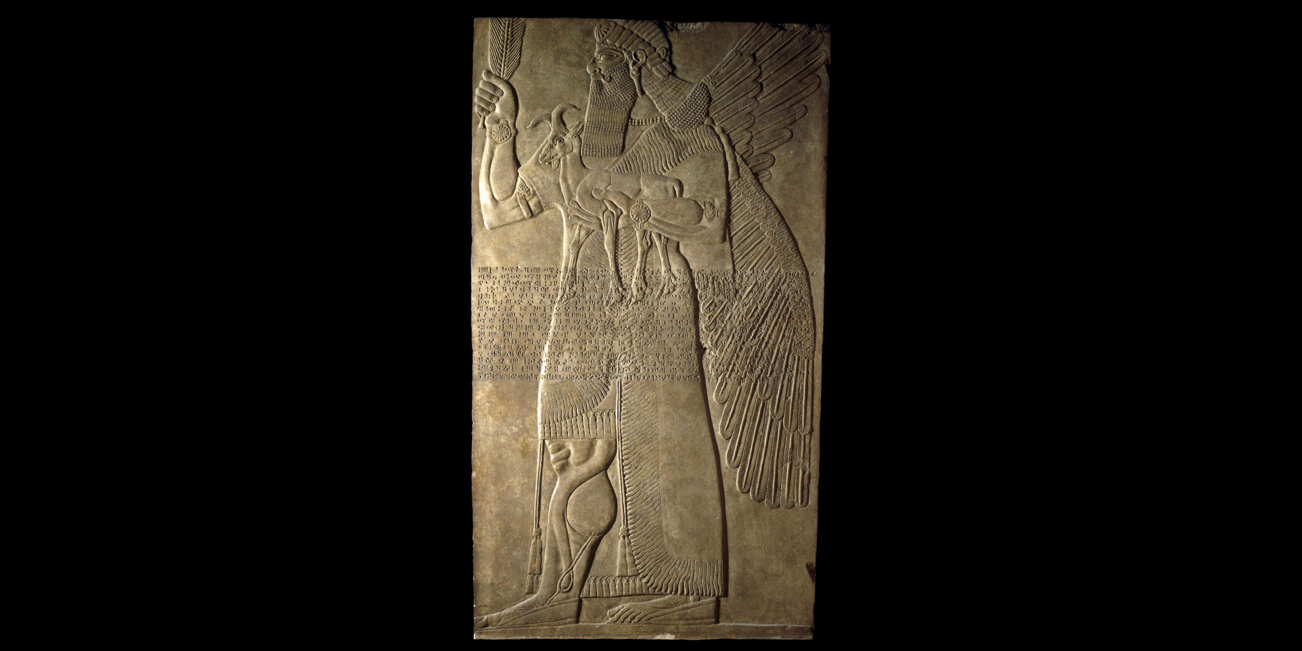
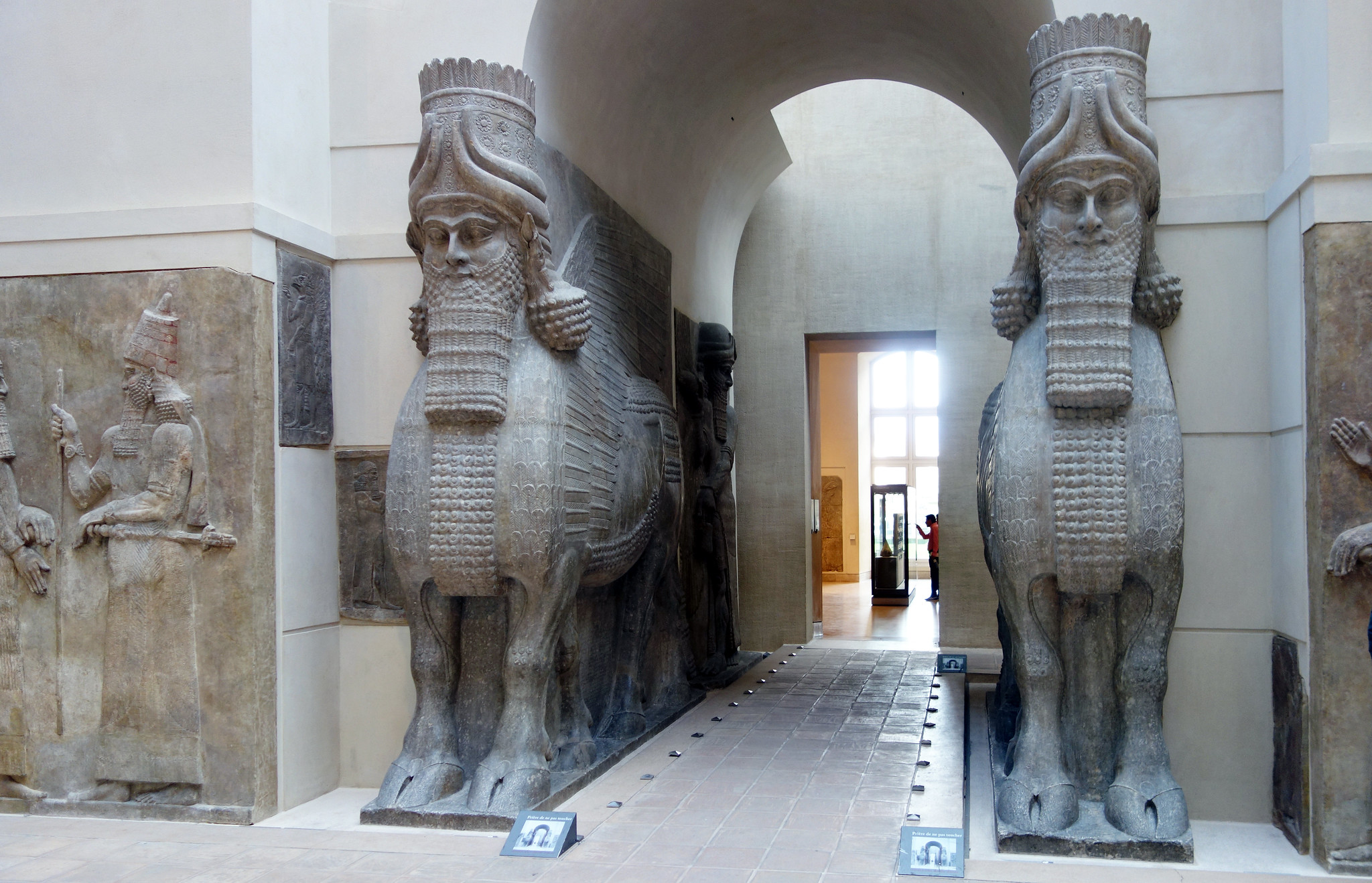
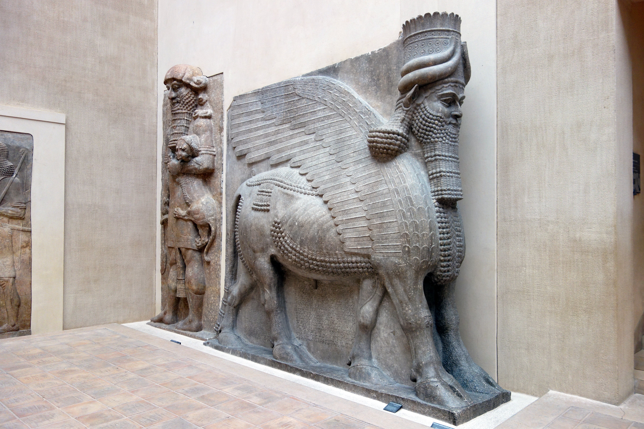
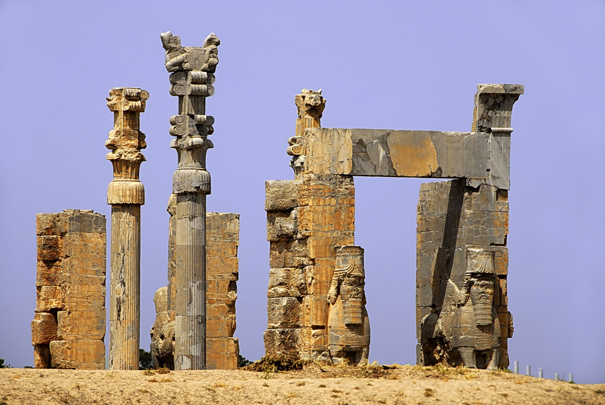
Lamassu (winged human-headed bulls possibly lamassu or shedu) from the citadel of Sargon II, Dur Sharrukin (now Khorsabad, Iraq), Neo-Assyrian, c. 720-705 B.C.E., gypseous alabaster, 4.20 x 4.36 x 0.97 m (Musée du Louvre, Paris; photo: Steven Zucker, CC BY-NC-SA 2.0)
In the king’s theocratic role, not only did he act as an intercessor between the gods and men but he could harness the power of mythoreligious characters such as Lamassu—hybrid man, bird, bull, or lion creatures. Images of Lamassu were created at a colossal scale and set in doorways leading to public spaces in palaces, through which visitors were compelled to pass. These would have had an awe-inspiring effect on the viewer. As with the White Temple and Ziggurat, the experience of confronting the Lamassu, the fear and astonishment it elicited, was critical to its function and power.
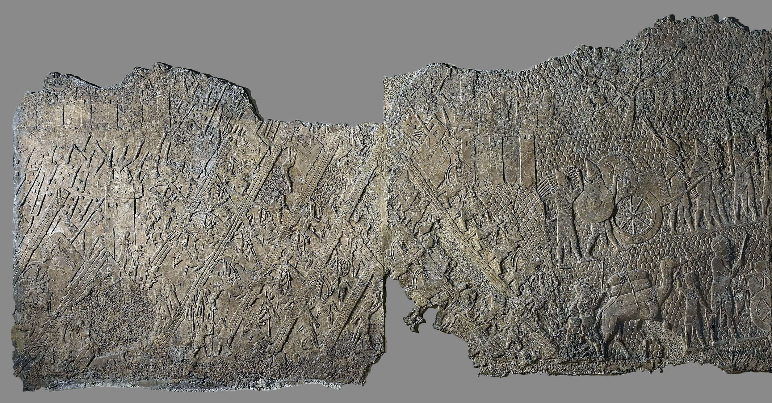
The Representation of Warfare
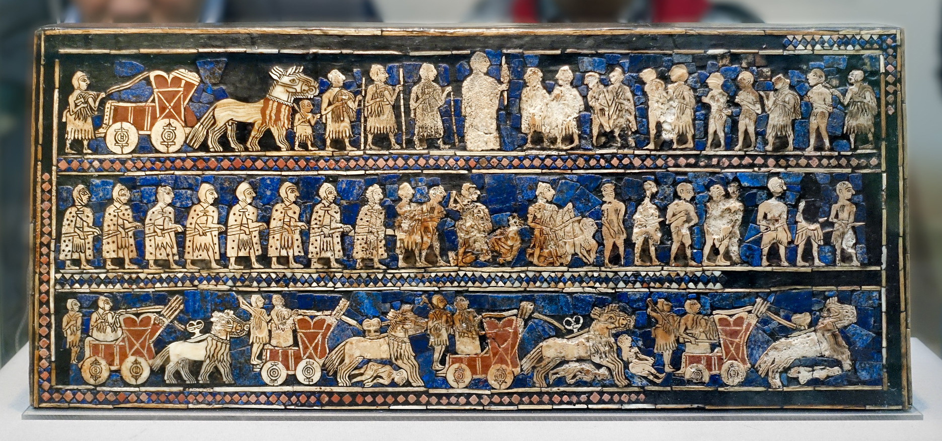
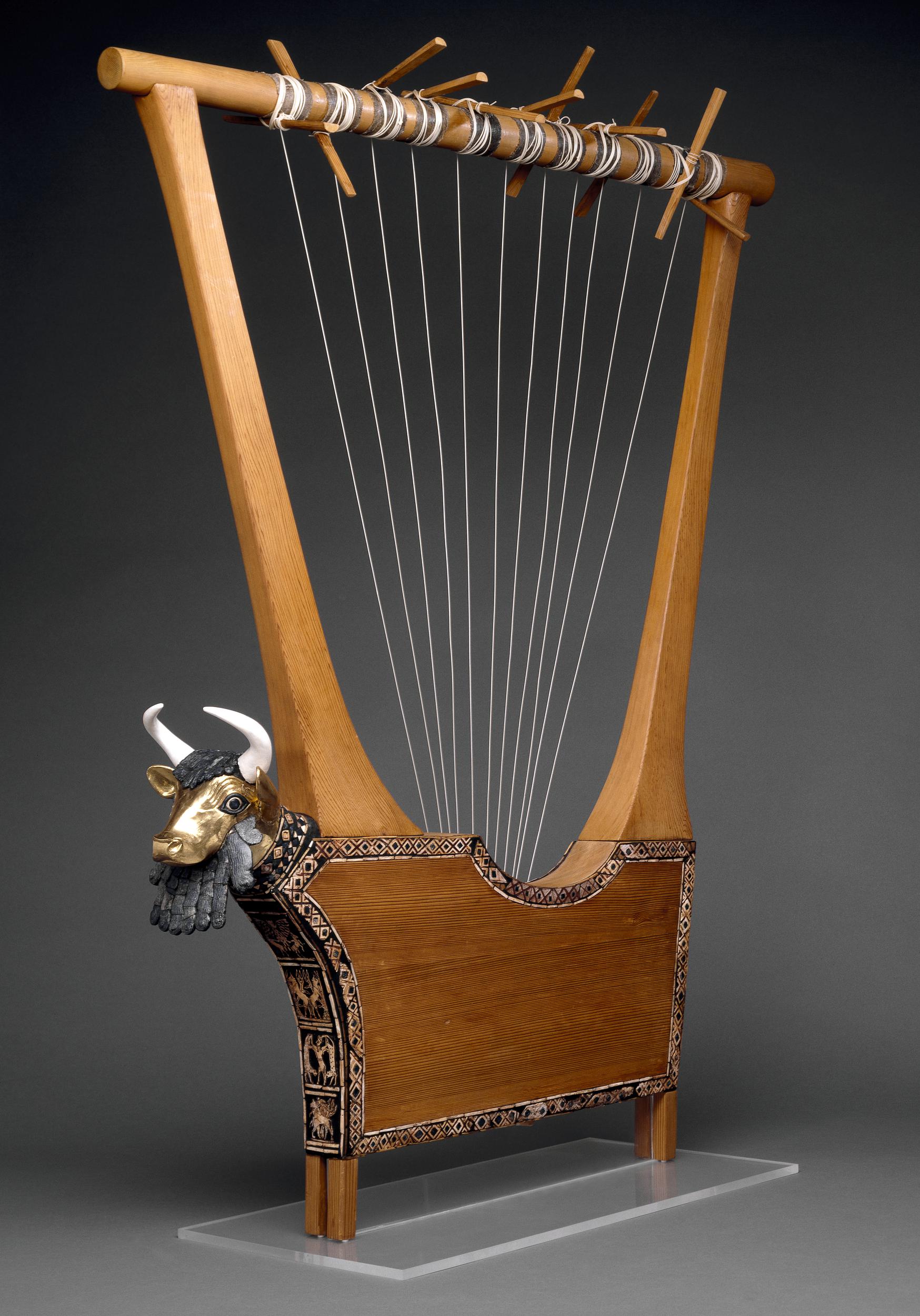
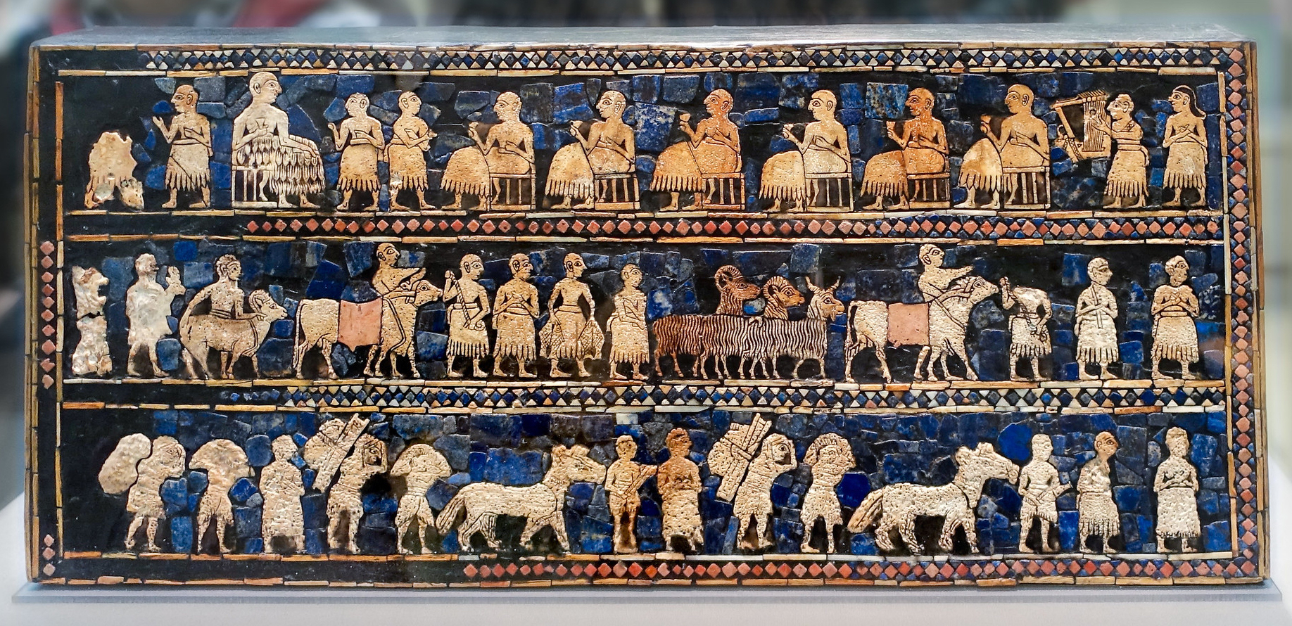
View of the side featuring images of war. The Standard of Ur, 2600–2400 B.C.E., shell, red limestone, lapis lazuli, and bitumen (original wood no longer exists), 21.59 x 49.53 x 12 cm (British Museum; photo: Steven Zucker, CC BY-NC-SA 2.0)
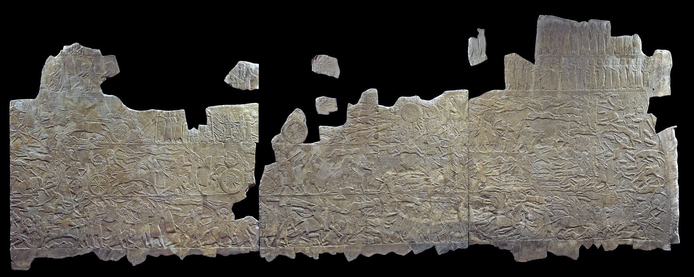
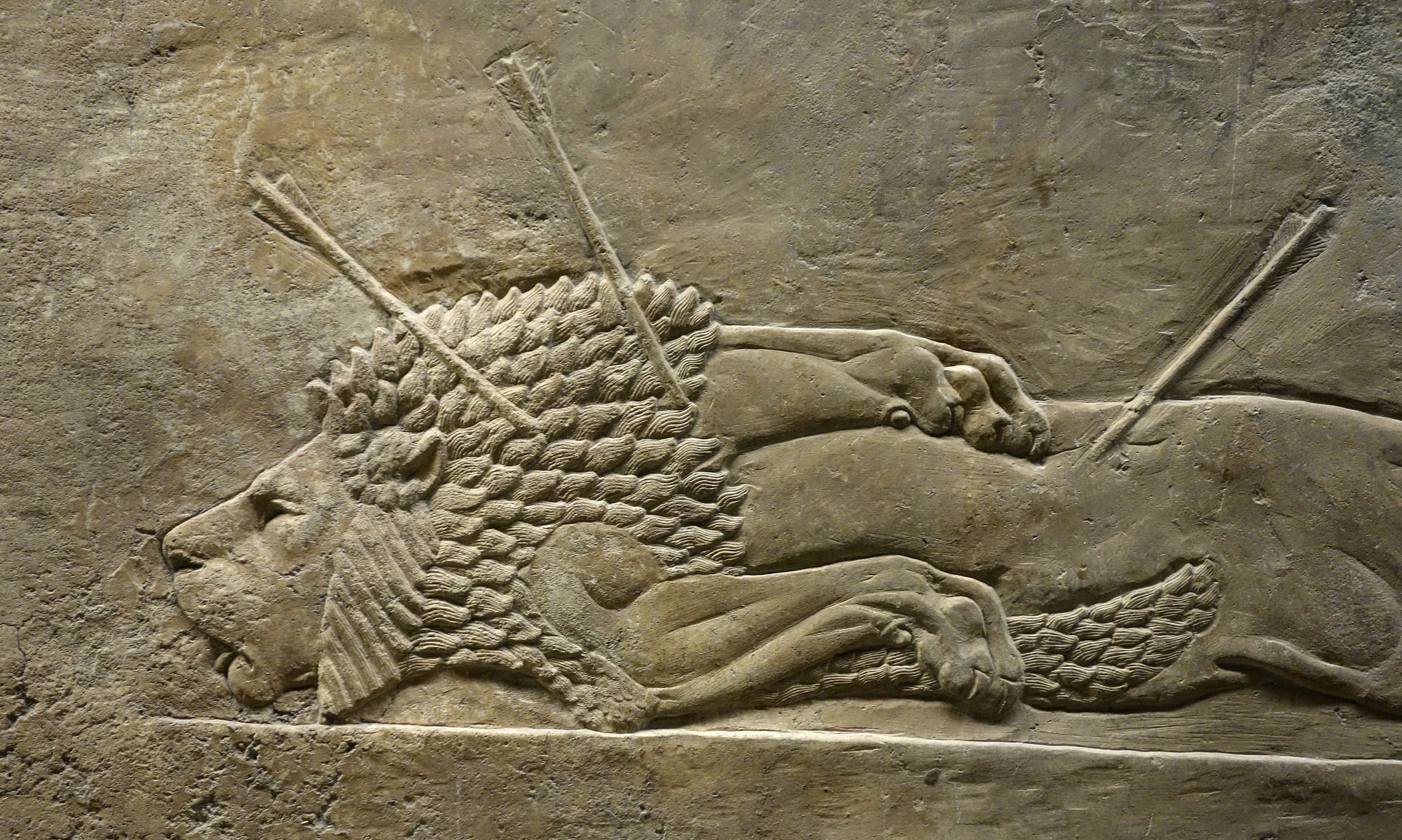
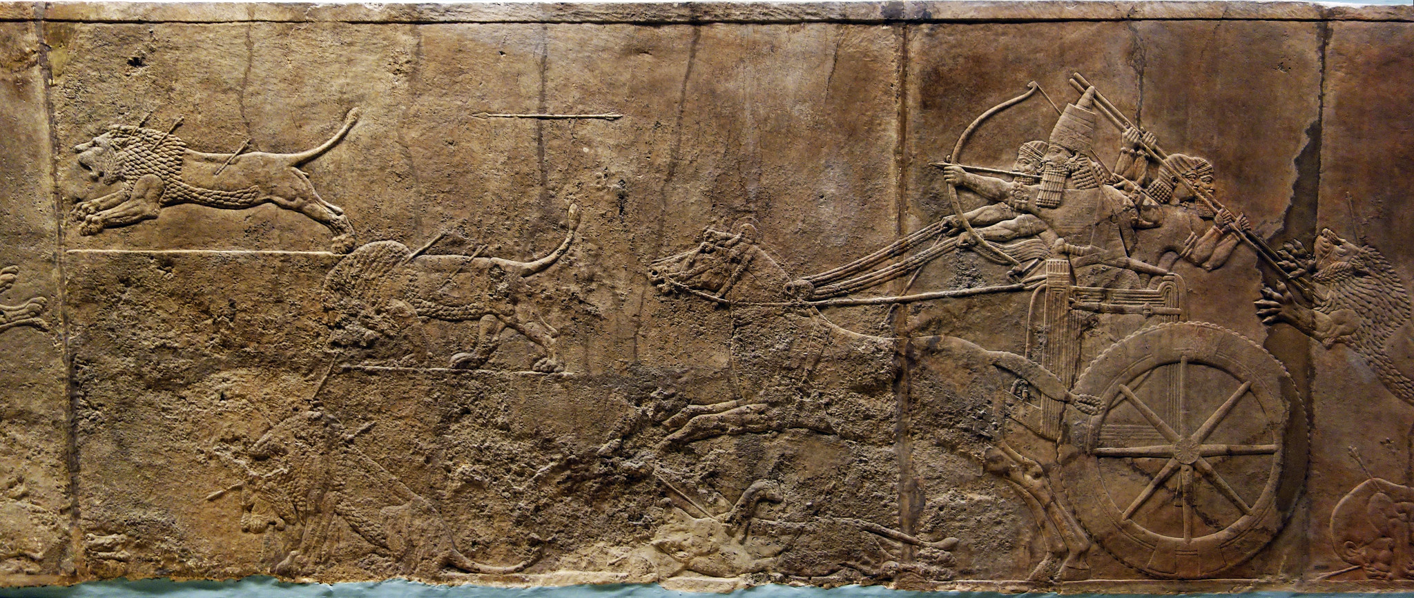
When the sites of the Ancient Near East were explored at the end of the 19th and early 20th century by English, French and German archaeologists, the objects, languages, and images found were entirely new to the modern world. However, one familiar theme was seen in these remains again and again: the representation of warfare—such as we see on objects like the Sumerian Standard of Ur or the Akkadian Victory Stele of Naram-Sin. Various examples of warfare can also be found on later Neo-Assyrian palace reliefs, for instance, those showing the battle of Til Tuba.
Across these examples and countless others, the representation of warfare, defeat, subjugation of the enemy, seizing of territory and resources are ritualized and presented as one of the supreme expressions of empire. Recent scholarship argues that the ritualization of war and images of violence constituted part of a magical technology of warfare that not only justified the underlying processes of war but presented a kind of control of its chaos. Only the king, aided by the gods, could wage such violence on such a massive scale; the huge numbers of soldiers, marching in tandem and formation, and the horrifying destruction they wrought, was seen as a sort of magical terror only unleashed by holy, kingly ritual.
By presenting the Sumerian, Akkadian, or Assyrian king as not only a warrior but master of the violence and spoils of war in his art, he is presented as all powerful and all controlling. This is nothing short of the origin of the public, political war monument—permeated with the propaganda of the victor.
Illustrating and monumentalizing war between nation states grew in popularity and political currency in the West in the 19th and 20th century, and often featured images of violent chaotic battle fields, fallen soldiers, and subjugated enemies (such as Eugene Delacroix’s Liberty Leading the People)—all strikingly similar to examples in the Ancient Near East. We can imagine that the visual ideology of ritualized war found in the archaeological remains of so many Ancient Near Eastern sites contributed to these modern images—naturalizing and universalizing the violent actions of the English and Germans busy excavating at Ur and Babylon.
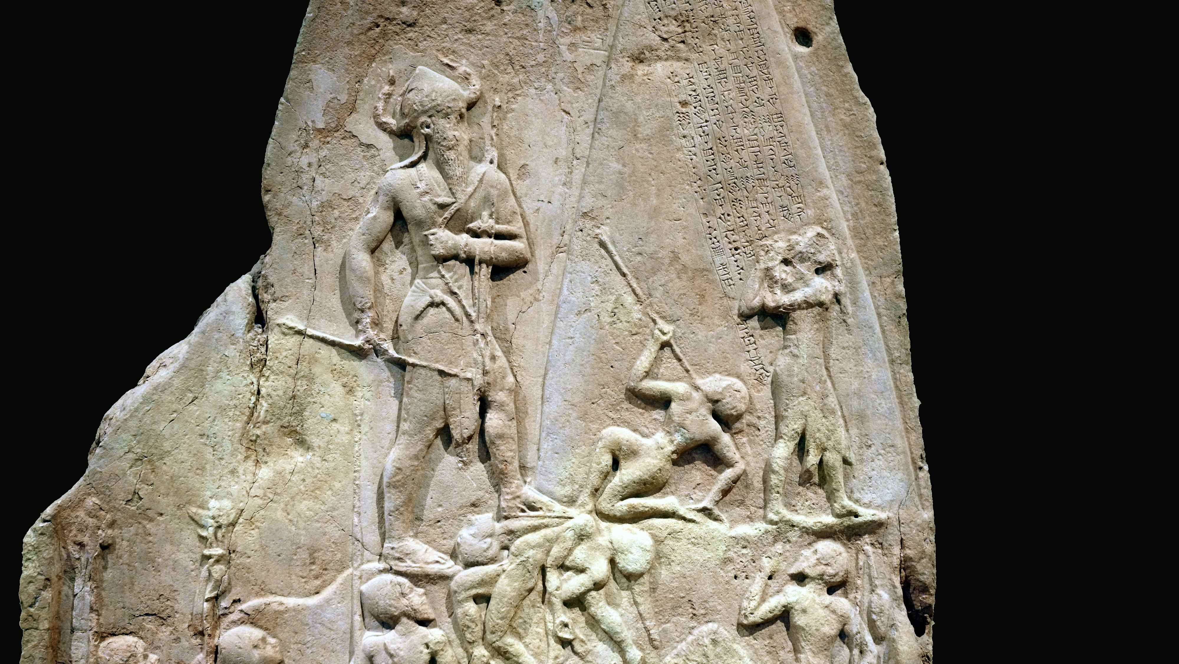
Victory Stele of Naram-Sin (detail), 2254–2218 B.C.E., pink limestone, Akkadian (Musée du Louvre, Paris)
Of course, the central focal point in the ancient images of war are the victorious armies and kings. But, at the bottom of these scenes, literally and figuratively, we find some of the earliest images of the tortured and trammeled. These details of contorted dead and dismembered bodies were part of the imaging of violence mentioned above, but they also stand as witness to dominated peoples, often missing in the annals of history, visual or written. In our own era of international humanitarian law (especially within the context of armed conflict) these fallen people are particularly poignant and remind us of our hard-won rights.
Writing, Women, and Sexuality
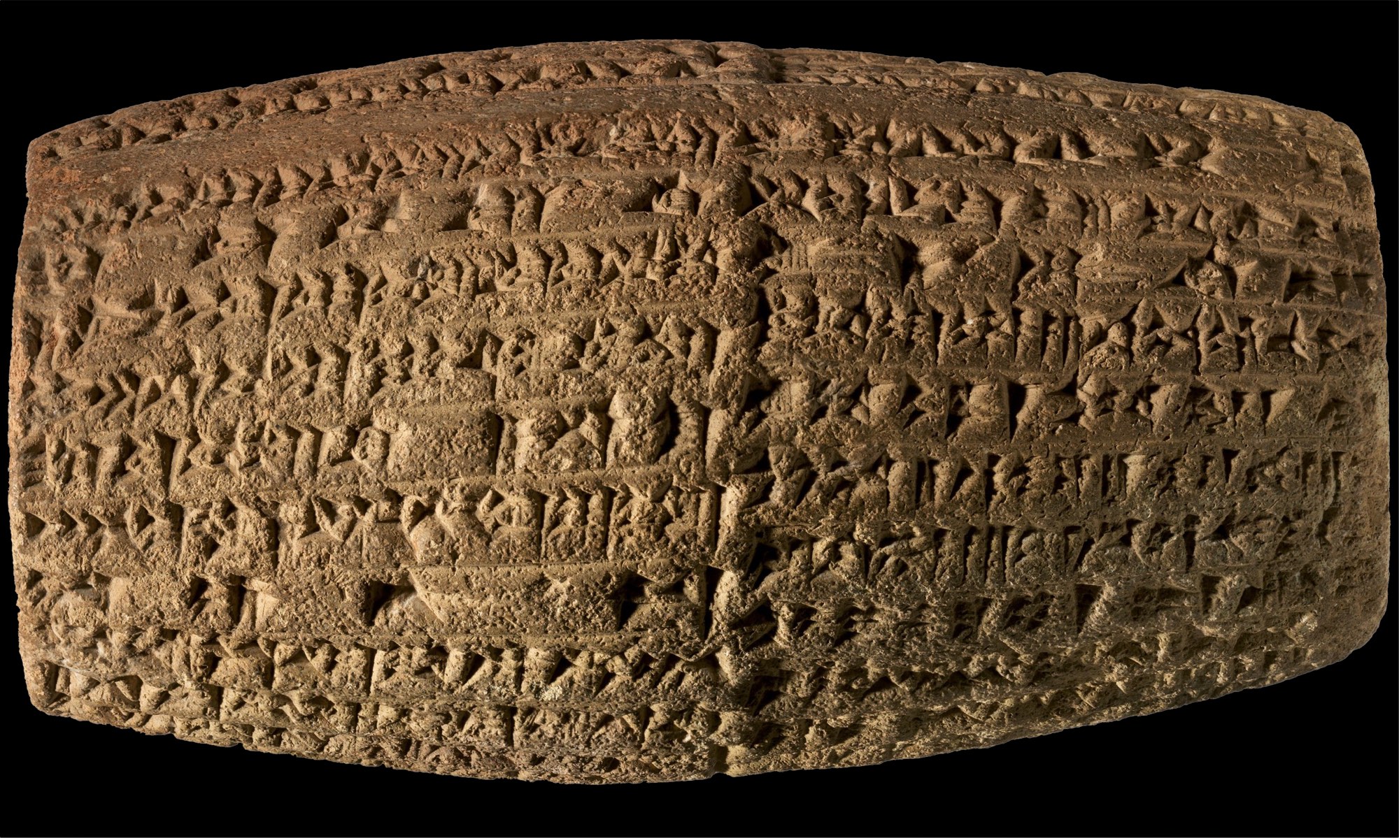
Cuneiform cylinder with inscription of Nebuchadnezzar II describing the construction of the outer city wall of Babylon, Neo-Babylonian, c. 604–562 B.C.E., clay, 6.7 × 12.35 × 7.2 cm (The Metropolitan Museum of Art)
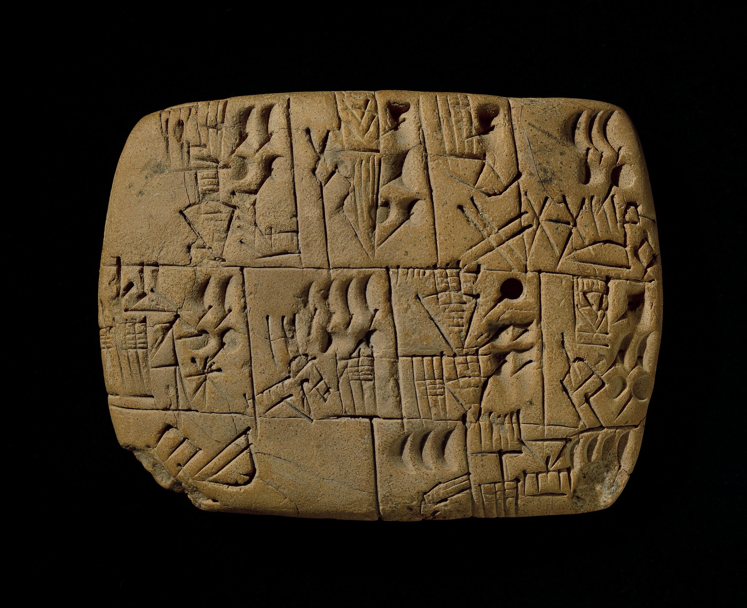
The circumstance of women in the Ancient Near East, as revealed through art and texts, is somewhat incongruous. Cuneiform tablets (clay slabs with writing on them), common among the remains of the era, are among the most important evidence of Ancient Near Eastern culture, not only an essential primary resource for the study of politics and economy but also a wellspring of first-person voice and lived narrative.
Among these documents we can read about thousands of individual women and discover that elite women acted in all the roles that men did, although in smaller numbers: they corresponded with men, kings, and each other; bought, sold, and loaned land and other critical commodities; borrowed and guaranteed debts; acted as witness in legal proceedings; participated in trading ventures, sometimes far from home and were frequent users of cylinder seals ( a small pierced object, like a long round bead, carved in reverse and hung on strings of fiber or leather. When a signature was required, the seal was taken out and rolled on the pliable clay document, leaving behind the positive impression of the reverse images carved into it.)
.
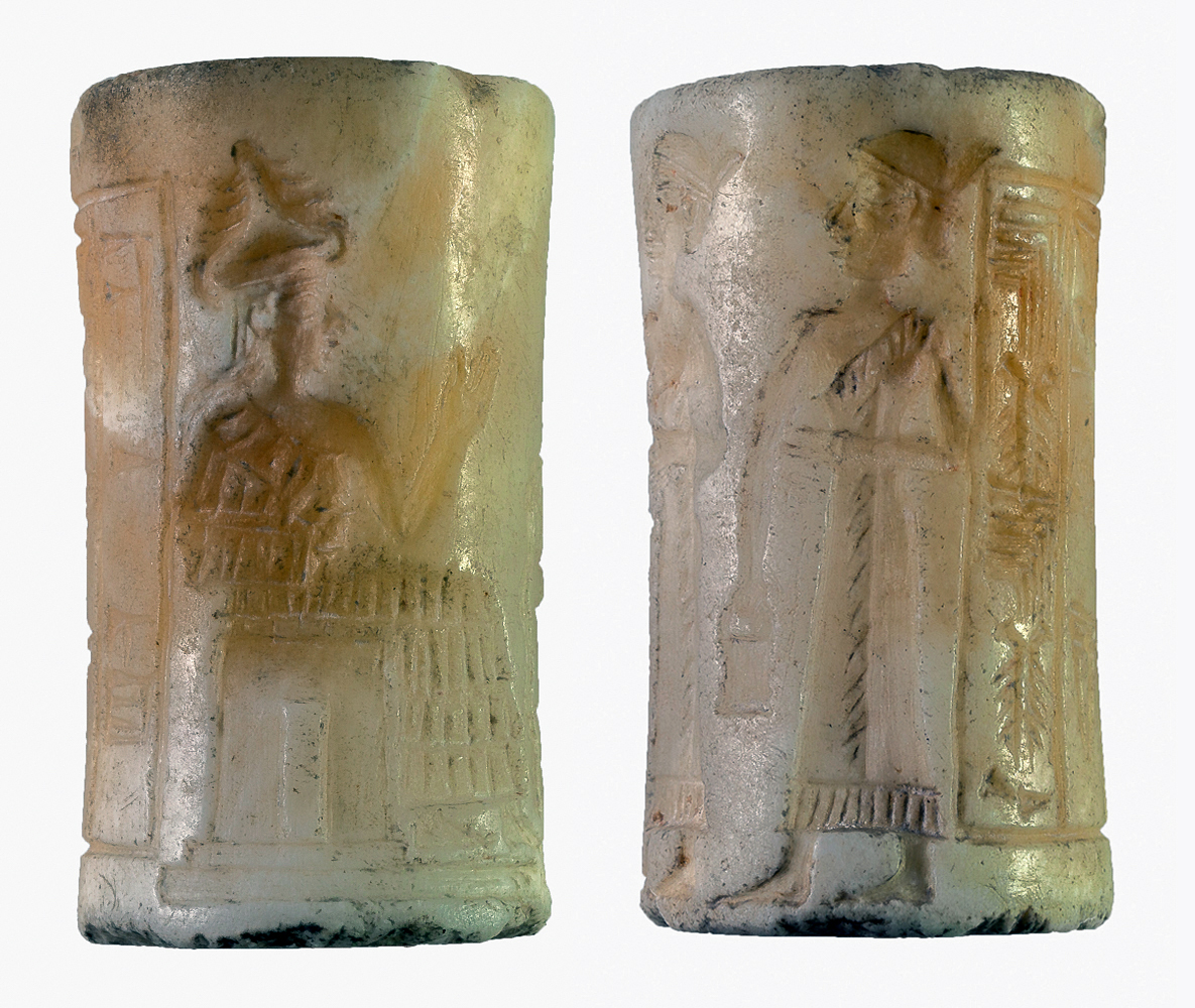
Cylinder seal, owned by a woman named Šaša, Akkadian, calcite, 39 x 22 mm, from Khafajeh, Iraq (Oriental Institute, University of Chicago)
Tens of thousands of cylinder seals were made and used in the Ancient Near East to minutely and intimately tell stories about men and women, priestesses and traders, kings and goddesses through images and writing understood and valued by all who saw them.
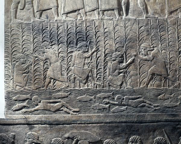
Scene of agricultural work and swimmers in river, c. 645 B.C.E., Assyrian, relief, from Royal Palaces of Nineveh (The British Museum)
Non-elite women are here too, part of a large work-force for physically demanding labor such as weaving, flour grinding, boat towing, and reed cutting. We find out about these laborers mostly through text, though there are some rare images such as those from the Assyrian palace at Nineveh that includes agricultural workers.
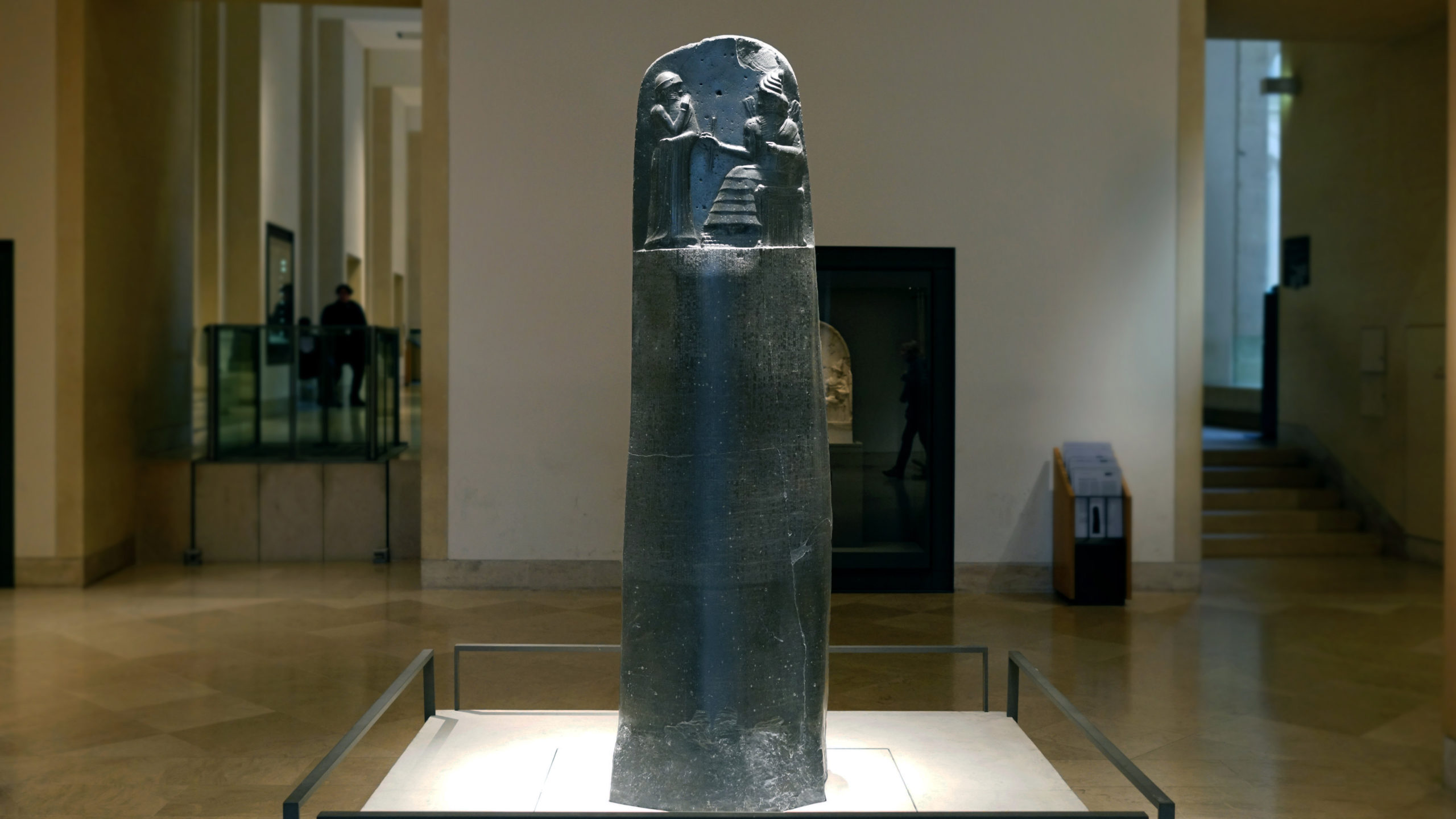
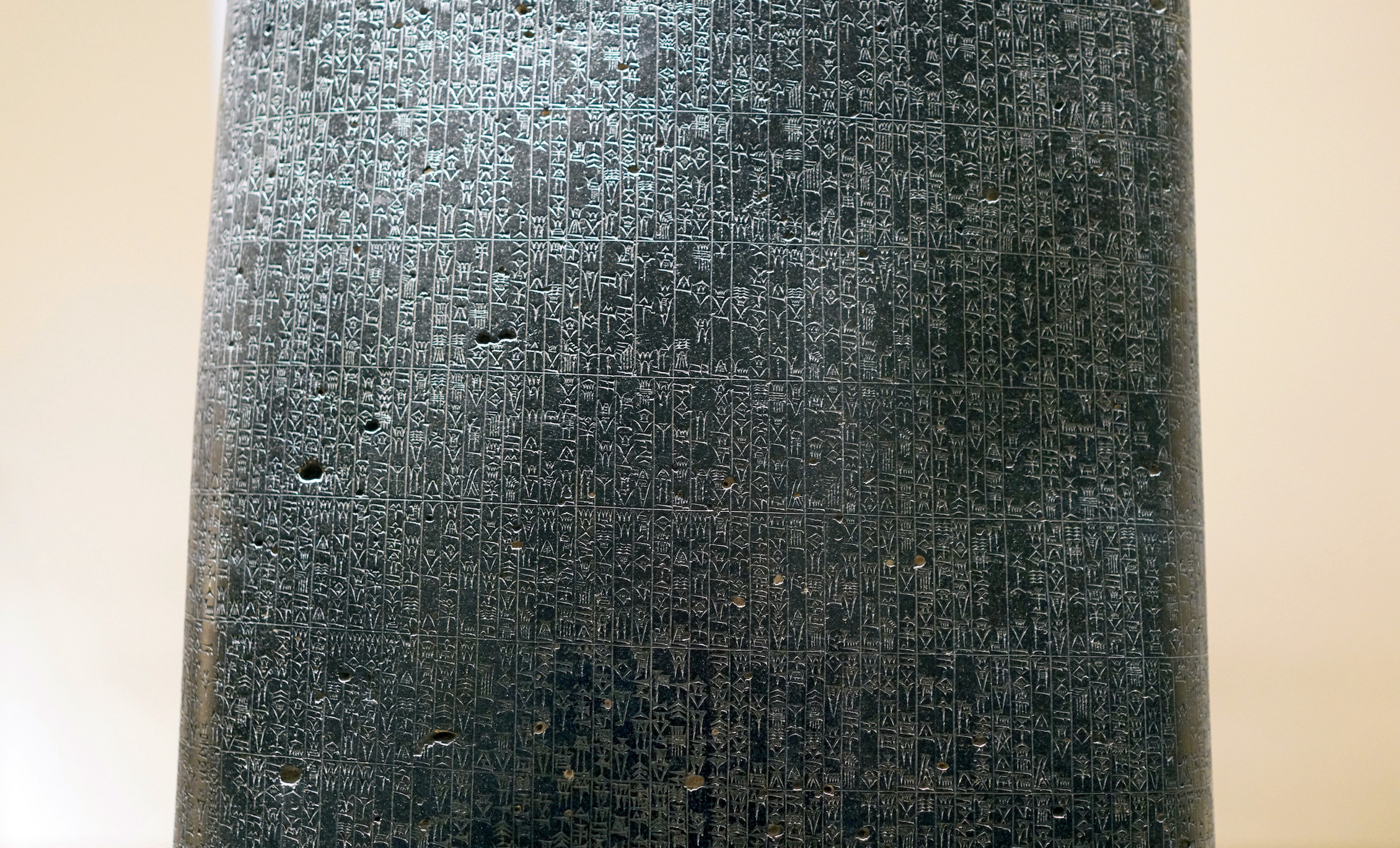
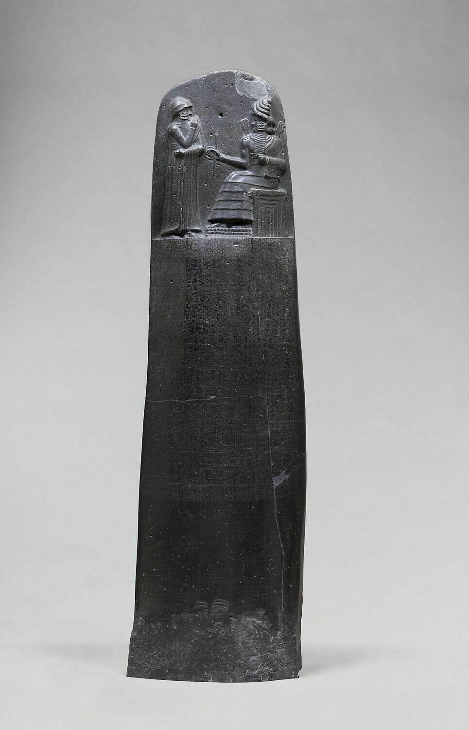
Law Code Stele of King Hammurabi, basalt, Babylonian, 1792–1750 B.C.E. (Musée du Louvre, Paris; photo: Steven Zucker, CC BY-NC-SA 2.0)
Most cuneiform comes down to us on clay tablets but some cuneiform inscriptions have been found engraved on stone statues, reliefs, or stelae. Probably the most famous example of a cuneiform engraved stele is that of Hammurabi.
Law Code Stele of King Hammurabi (detail), basalt, Babylonian, 1792–1750 B.C.E. (Musée du Louvre, Paris; photo: Steven Zucker, CC BY-NC-SA 2.0)
The stele of Hammurabi, also called the law code of Hammurabi, dates to the 18th century B.C.E. and contains laws which, taken together, represent one of the earliest legal codes. It is a nearly encyclopedic compendium of law, known through multiple copies, and is particularly sympathetic to workers (for instance, a sort of minimum wage is included in it) and establishes a high bar of proof of crime, put upon the accuser, another legal mechanism which aids non-elites.
Some laws that relate to women
129. If the wife of a man is caught lying with another man, they shall bind them and throw them into the water. If the husband of the woman wishes to spare his wife, then the king shall spare his servant.
130. If a man has ravished another’s betrothed wife, who is a virgin, while still living in her father’s house, and has been caught in the act, that man shall be put to death; the woman shall go free.
131. If a man has accused his wife but she has not been caught lying with another man, she shall take an oath in the name of god and return to her house.
138. If a man wishes to divorce his wife who has not borne him children, he shall give her money to the amount of her marriage price and he shall make good to her the dowry which she brought from her father’s house and then he may divorce her.
141. If the wife of a man who is living in her husband’s house, has persisted in going out, has acted the fool, has waster her house, has belittled her husband, he shall prosecute her. If her husband has said, “I divorce her,” she shall go her way; he shall give her nothing as her price of divorce. If her husband has said “I will not divorce her” he may take another woman to wife; the wife shall live as a slave in her husband’s house.
142. If a woman has hated her husband and has said, “You shall not possess me,: her past shall be inquired into, as to what she lacks. If she has been discreet, and has no vice, and her husband has gone out, and has greatly belittled her; that woman has not blame, she shall take her marriage portion and go off to her father’s house.
143. If she has not been discreet, has gone out, ruined her house, belittled her husband, she shall be drowned.
150. If a man has presented a field, garden, house, or goods to his wife, has granted her a deed of gift, her children, after her husband’s death, shall not dispute her right; the mother shall leave it after her death to that one of her children whom she loves best. She shall not leave it to an outsider.
From the Code of Hammurabi
In this law code, we find that women enjoyed a surprising measure of rights. Marriage and monogamy were central to female legal frameworks and within this women were treated relatively well. For instance, if stipulated in a marriage contract, women were free of their husband’s premarital debts. Women could inherit property from their husbands’ estates and could own their own property outright. Divorce was allowed and, when initiated by the husband, the wife’s dowry had to be returned and, in the case of children, half the husband’s estate had to be given to the wife. However, when a woman initiated divorce (a remarkable right included in the law code) her character was put on trial and, unless she was found above reproach, she would be put to death. Moreover, crimes against women such as rape, robbery, or perjury resulted in death of the perpetrator, showing the value of women, married or otherwise, in society.
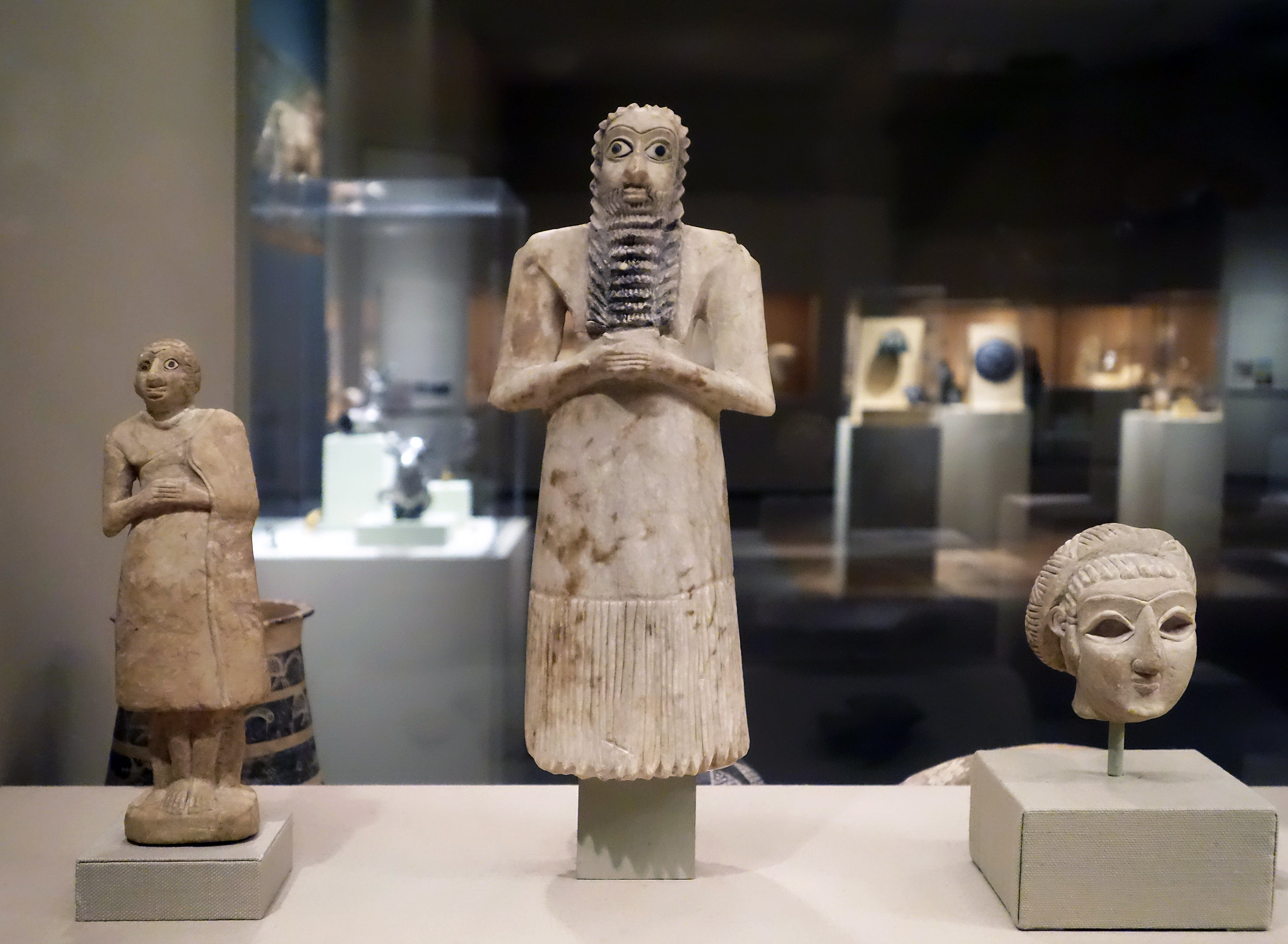
Standing worshippers, 2750–2600 B.C.E., Early Dynastic period II (Sumerian), excavated at Tell Asmar (ancient Eshnunna), Iraq, alabaster (gypsum), shell, black limestone; 11-5/8 inches (29.5 cm) high (The Metropolitan Museum of Art; photo: Steven Zucker, CC BY-NC-SA 2.0)
However, despite this clear evidence of the important economic, social, and political roles that women played, there are few representations of them (besides divine women and priestesses) in Ancient Near Eastern art. Indeed, some elite women—mostly priestesses—are shown especially on cylinder seals, and elite female worshipers (possibly priestesses) were found among the figurines discovered at the Square Temple at Eshnunna.
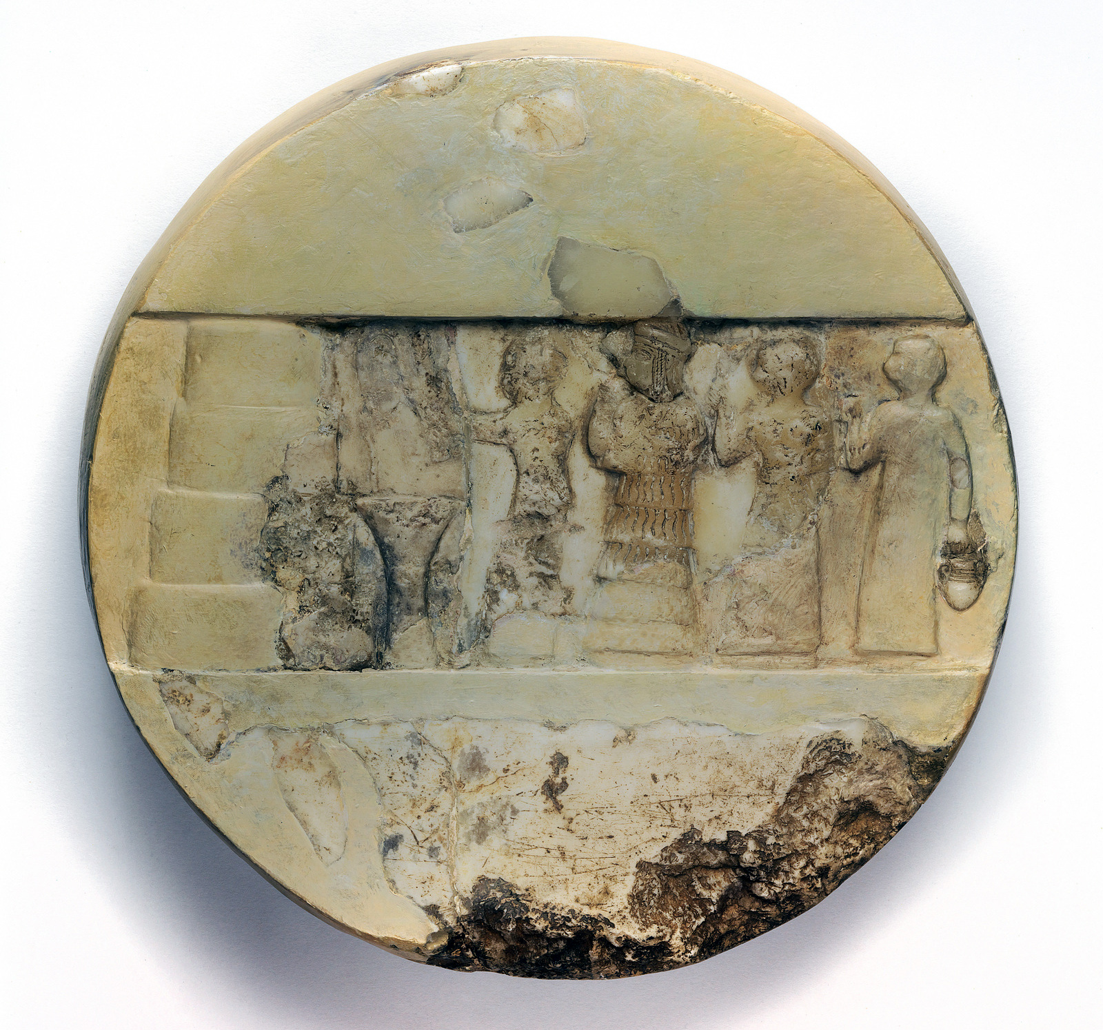
The high priestess Enheduanna is shown performing a ritual to the moon goddess Nanna. Relief of Enheduanna, Old Akkadian Period, c. 2340–2200 B.C.E., limestone and calcite, 25 cm diameter, from Ur, Iraq, found in a chamber of the Larsa temple of Nin-Gal (the Gig-par-ku) (Penn Museum)
And, one individual woman’s representation survives, that of Enheduanna, on a limestone disk which bears her name, found at Ur dating to around 2200 B.C.E. Enheduanna was a high priestess of the moon goddess Nanna and is shown on the disk performing a ritual to her. Enheduanna was also the daughter of Sargon, the founder of the Akkadian empire, no doubt a major factor in her prominence. But what she is really known for is her poetry. Enheduana was the author of several temple hymns which were so highly regarded that they were copied and recopied for several hundred years. Enheduanna is recognized as the first author—of any gender—we know.
from The Hymn to Inanna
Lady of all powers,
In whom light appears,
Radiant one
Beloved of Heaven and Earth,
Tiara-crowned
Priestess of the Highest God,
My Lady, you are the guardian
Of all greatness.
Your hand holds the seven powers:
You lift the powers of being,
You have hung them over your finger,
You have gathered the many powers,
You have clasped them now
Like necklaces onto your breast.
[. . .]
It was in your service
That I first entered
The holy temple,
I, Enheduanna,
The highest priestess.
I carried the ritual basket,
I chanted your praise.
Now I have been cast out
To the place of lepers.
Day comes,
And the brightness
Is hidden around me.
Shadows cover the light,
Drape it in sandstorms.
My beautiful mouth knows only confusion.
Even my sex is dust. [. . .]
Translation by Jane Hirshfield. Women in Praise of the Sacred, edited by Jane Hirshfield (HarperCollins Publishers Inc., 1994).
Interestingly, there would appear to be a “middle” class of woman in the Ancient Near East, those who were not part of the laboring or slave classes nor the elite, and who were not under the patriarchal control of either a father or husband. These women, called harimtu, are well attested to in the Akkadian empire, and were neither married nor widowed. Some were rich, some poor, and all appear to have been rather independent. Harimtu is a label also quite commonly interpreted as sex worker. There is a lively debate among philologists and historians as to the precise role and status of harimtu but it would appear that at least some were engaged in sex work associated with temples; there was an association between sex and the divine, so there were women at the temples who had sex with congregants as a type of prayer or pious act. Indeed, if harimtu were sex workers, then images of them likely remain among the many examples of erotic terracotta plaques.
Images of sex, both heterosexual and homosexual, were not uncommon in the Ancient Near East. Through reading sacred texts it becomes clear that sexual desire was considered a divine force and because of this prayers to bring on male and female sexual desire and satisfaction are common. It is thought that these erotic plaques therefore had some sort of cultic function or at least participated in aspirations of sexual and spiritual fulfillment.
Questioning the Cradle of Civilization
The Cradle of Civilization—this phrase is often used to refer to Mesopotamia. But is it time we complicated that idea more?
The search for the origin of things has been a preoccupation throughout all of human history. Whether through religion, science, or history, we strive to know and understand where things come from because we believe that those origins are meaningful. The origin of civilization is no different. Civilization is understood as a collection of circumstances and practices, typically defined by urban living, a spectrum of wealth, from rich to poor, some form of government or social organization, monumental architecture, craft specialization, and a written language. According to what we know archaeologically, all these circumstances and practices can indeed be found for the first time at Uruk in Southern Mesopotamia at the end of the 5th millennium.
Tell Brak, Syria, area TW, showing the 5th–6th century millennium B.C.E. levels (photo: Bertramz, CC BY 3.0)
However, this first-place prize is only narrowly won. Evidence from sites such as Tell Brak in modern Syria suggest that cities and writing may have developed in northern Mesopotamia at the same time or even before those in the south. At roughly the same time, in Egypt, sites of the Predynastic period (such as Abydos and Naqada), also appear to have all the characteristics of civilization.
Therefore, it looks as if the beginning of civilization was a phenomenon that occurred at the same time very broadly, from southern Mesopotamia to the edges of the northern Levant to the northeast coast of Africa.
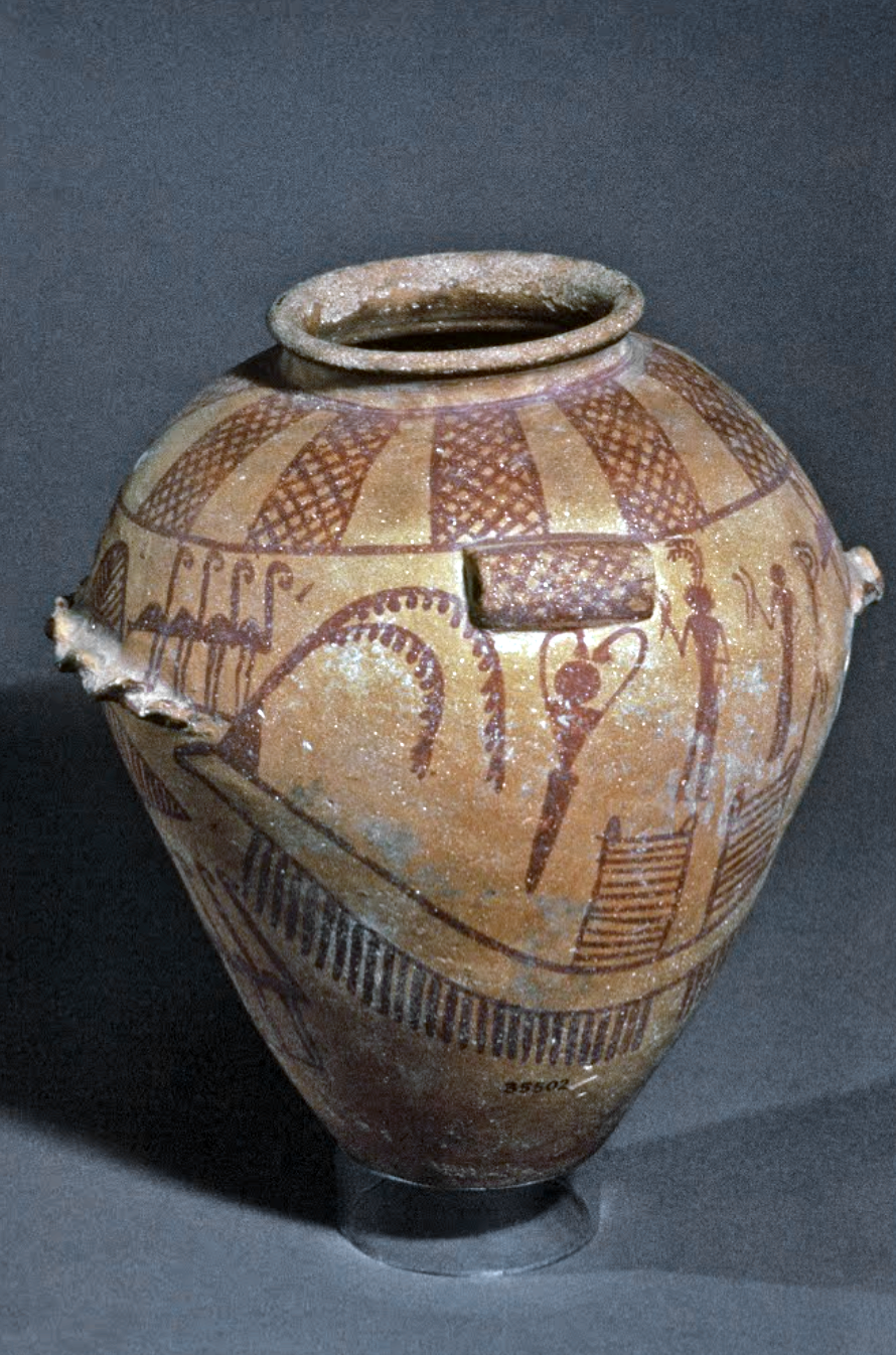
Bushel with ibex motifs, 4200–3500 B.C.E., painted terra-cotta, 28.90 x 16.40 cm, necropolis, Susa I period, from the acropolis mound, Susa, Iran (Musée du Louvre, Paris; photo: Steven Zucker, CC BY-NC-SA 2.0)
In the Near East, the site of Susa was a center of spectacular pottery production, such as we see on a bushel with ibex motifs.
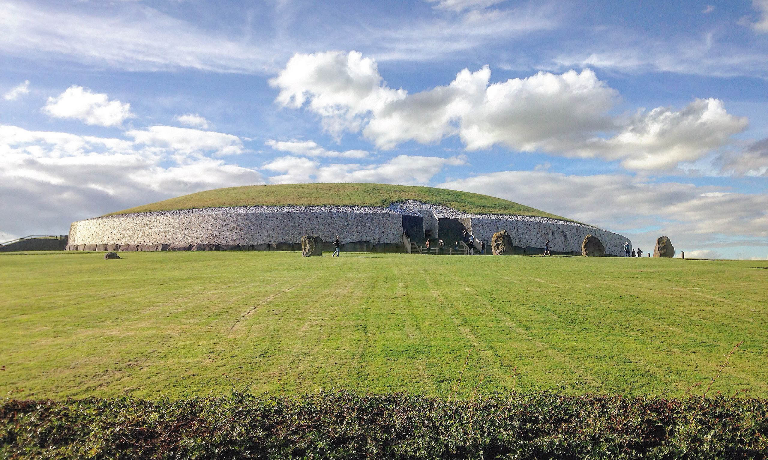
Newgrange, Brú na Bóinne Complex, c. 3200 B.C.E., Republic of Ireland
Or, further afield, in the Republic of Ireland at the Brú na Bóinne Complex of monumental structures or Stonehenge in England.
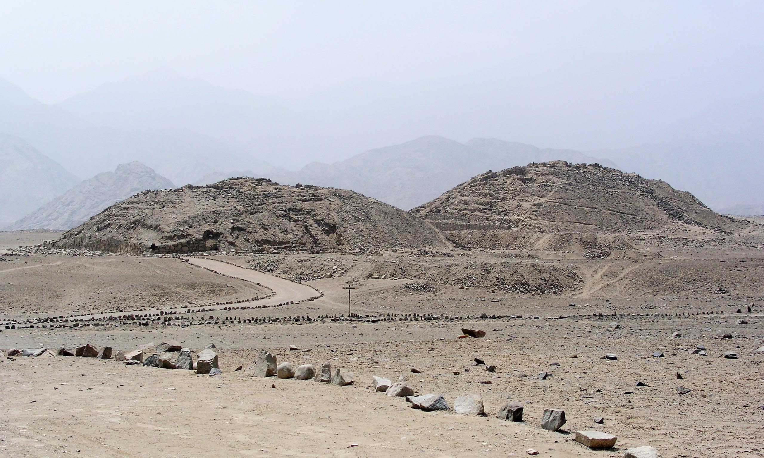
Caral-Supe cultural developed c. 3000–1800 B.C.E., and the city of Caral is currently considered the oldest in the Americas. Caral-Supe, in the Supe Valley, Peru (photo: Xauxa, CC BY 2.5)
And then of course, if we look even further beyond, in places like China, India, and Peru, things become more complicated. If this is the case, it is harder to place the “cradle” so singularly.
We might at the same time think about why certain characteristics make an early site “civilized” and others do not. The concept of civilization was developed as part of 18th-century French, British, and German Enlightenment philosophy focused on the pursuit of happiness, knowledge and human freedoms—and ultimately was used to justify slavery. Enlightenment philosophy taught that cultures which had achieved urbanism, stratified society in governmental structures, and written languages—what was believed to be the ultimate expression of human endeavor: enlightenment—were at the top of the evolutionary scale; those which had not were at the bottom and therefore, logically, less developed and, ultimately, servile to the higher orders.
This judgment and ordering of cultures remained largely unchallenged through the 18th, 19th, and even early 20th century, the period in which many sites in the Near East were excavated. Therefore, the cultures of the Ancient Near East, by this logic, were deemed “civilized.” However, there was another factor which automatically elevated ancient Near Eastern cultures: their connections to biblical narratives. The lands of the Ancient Near East held the birthplace of both Judaism and Christianity; sites such as Jericho, Nazareth, Jerusalem, Babylon, Nineveh, Tyre, the homes of Old Testament Kings and Jesus himself. The ancient remains of these sites, by association with Christianity, the dominant faith of the West from the Renaissance until the 20th century and intimately connected with concepts of European superiority, were regarded as “civilized.”
Today such racial approaches to history are strongly rejected and the ordering of cultures as more or less civilized is also swiftly losing value. Once we are no longer preoccupied with compiling lists of cultural traits we can instead focus on unique cultural production, and the list of early “cradles” of civilization in the 4th millennium expands.
So, although re-evaluating the idea of what culture gets the title “the cradle of civilization” might knock southern Mesopotamia off the pedestal it has so long occupied, it offers us an opportunity to appreciate the importance of other contemporary cultural achievements and realize that we gain more by opening up our view of the 4th millennium. By focusing on quieter voices, those of the vanquished and that of women, by rethinking the idea of the “cradle of civilization,” and by de-emphasizing imperial narratives of the Ancient Near East, a fuller picture of the art of the era emerges.
terms used in describing works of art: relief (low and high), register, ground line, frontality, composite pose (a combination of frontal and profile views), stele (or stelae), hierarchic scale, monolith, iconography
Ancient Near East: Cradle of civilization
by DR. SENTA GERMAN
Home to some of the earliest and greatest empires, the Near East is often referred to as the cradle of civilization.
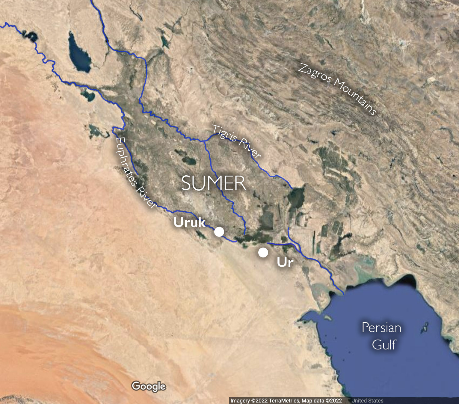
Some of the earliest complex urban centers can be found in Mesopotamia between the Tigris and Euphrates rivers (early cities also arose in the Indus Valley and ancient China). The history of Mesopotamia, however, is inextricably tied to the greater region, which is comprised of the modern nations of Egypt, Iran, Syria, Jordan, Israel, Lebanon, the Gulf states and Turkey. We often refer to this region as the Near or Middle East.
What’s in a name?
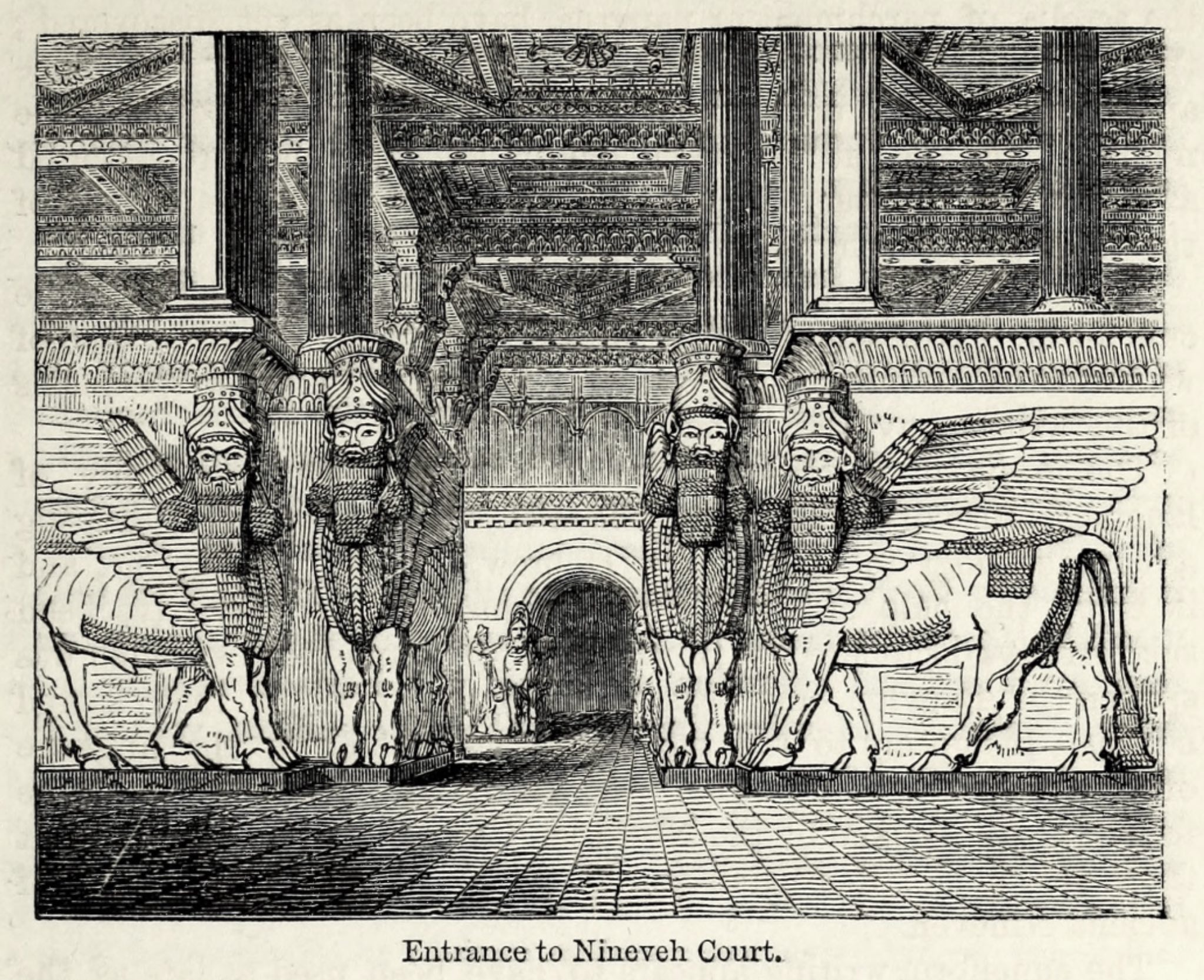
Why is this region named this way? What is it in the middle of or near to? It is the proximity of these countries to the West (to Europe) that led this area to be termed “the near east.” Ancient Near Eastern Art has long been part of the history of Western art, but history didn’t have to be written this way. It is largely because of the West’s interests in the Biblical “Holy Land” that ancient Near Eastern materials have been regarded as part of the Western canon of the history of art. An interest in finding the locations of cities mentioned in the Bible (such as Nineveh and Babylon) inspired the original English and French 19th century archaeological expeditions to the Near East. These sites were discovered and their excavations revealed to the world a style of art which had been lost.
Entrance to Ninevah Court, Illustration from: Sir Austen Henry Layard, The Ninevah Court in the Crystal Palace (London: Bradbury and Evans, 1854), p. 39.
The excavations inspired The Nineveh Court at the 1851 World’s Fair in London and a style of decorative art and architecture called Assyrian Revival. Ancient Near Eastern art remains popular today; in 2007 a 2.25 inch high, early 3rd millennium limestone sculpture, the Guennol Lioness, was sold for 57.2 million dollars, the second most expensive piece of sculpture sold at that time.
A complex history
The history of the Ancient Near East is complex and the names of rulers and locations are often difficult to read, pronounce and spell. Moreover, this is a part of the world which today remains remote from the West culturally while political tensions have impeded mutual understanding. However, once you get a handle on the general geography of the area and its history, the art reveals itself as uniquely beautiful, intimate and fascinating in its complexity.
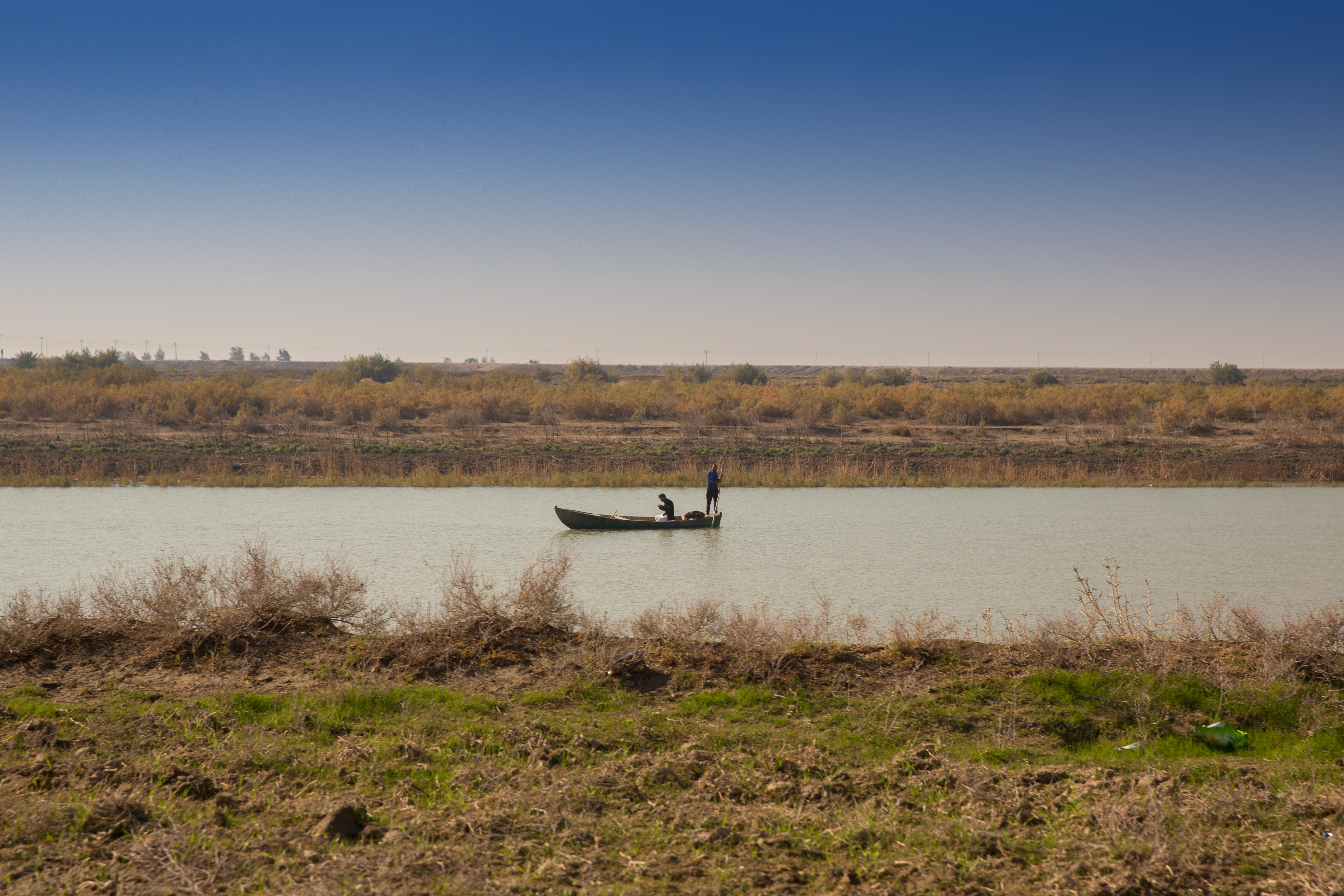
A fishing boat in the Euphrates Southern Iraq (photo: Aziz1005, CC BY 4.0)
Geography and the growth of cities
Mesopotamia remains a region of stark geographical contrasts: vast deserts rimmed by rugged mountain ranges, punctuated by lush oases. Flowing through this topography are rivers and it was the irrigation systems that drew off the water from these rivers, specifically in southern Mesopotamia, that provided the support for the very early urban centers here.
The region lacks stone (for building), precious metals and timber. Historically, it has relied on the long-distance trade of its agricultural products to secure these materials. The large-scale irrigation systems and labor required for extensive farming was managed by a centralized authority. The early development of this authority, over large numbers of people in an urban center, is really what distinguishes Mesopotamia and gives it a special position in the history of Western culture. Here, for the first time, thanks to ample food and a strong administrative class, the West develops a very high level of craft specialization and artistic production.
The earliest writing we know of dates back to around 3000 B.C.E. and was probably invented by the Sumerians, living in major cities with centralized economies in what is now southern Iraq. The earliest tablets with written inscriptions represent the work of administrators, perhaps of large temple institutions, recording the allocation of rations or the movement and storage of goods. Temple officials needed to keep records of the grain, sheep, and cattle entering or leaving their stores and farms and it became impossible to rely on memory. So, an alternative method was required and the very earliest texts were pictures of the items scribes needed to record (known as pictographs).
Writing, the recording of a spoken language, emerged from earlier recording systems at the end of the fourth millennium. The first written language in Mesopotamia is called Sumerian. Most of the early tablets come from the site of Uruk, in southern Mesopotamia, and it may have been here that this form of writing was invented.
These texts were drawn on damp clay tablets using a pointed tool. It seems the scribes realized it was quicker and easier to produce representations of such things as animals, rather than naturalistic impressions of them. They began to draw marks in the clay to make up signs, which were standardized so they could be recognized by many people.
Cuneiform
From these beginnings, cuneiform signs were put together and developed to represent sounds, so they could be used to record spoken language. Once this was achieved, ideas and concepts could be expressed and communicated in writing.
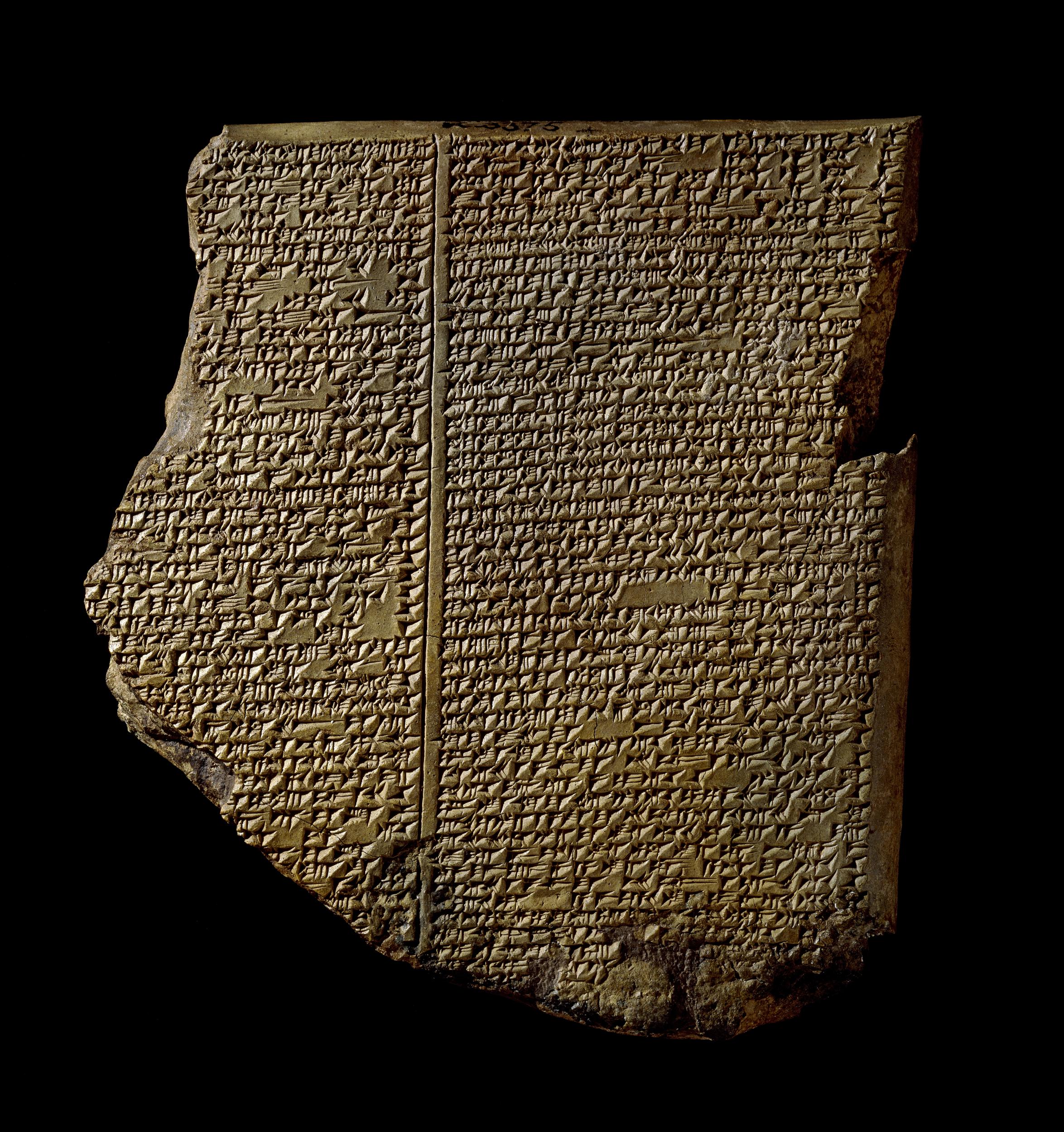
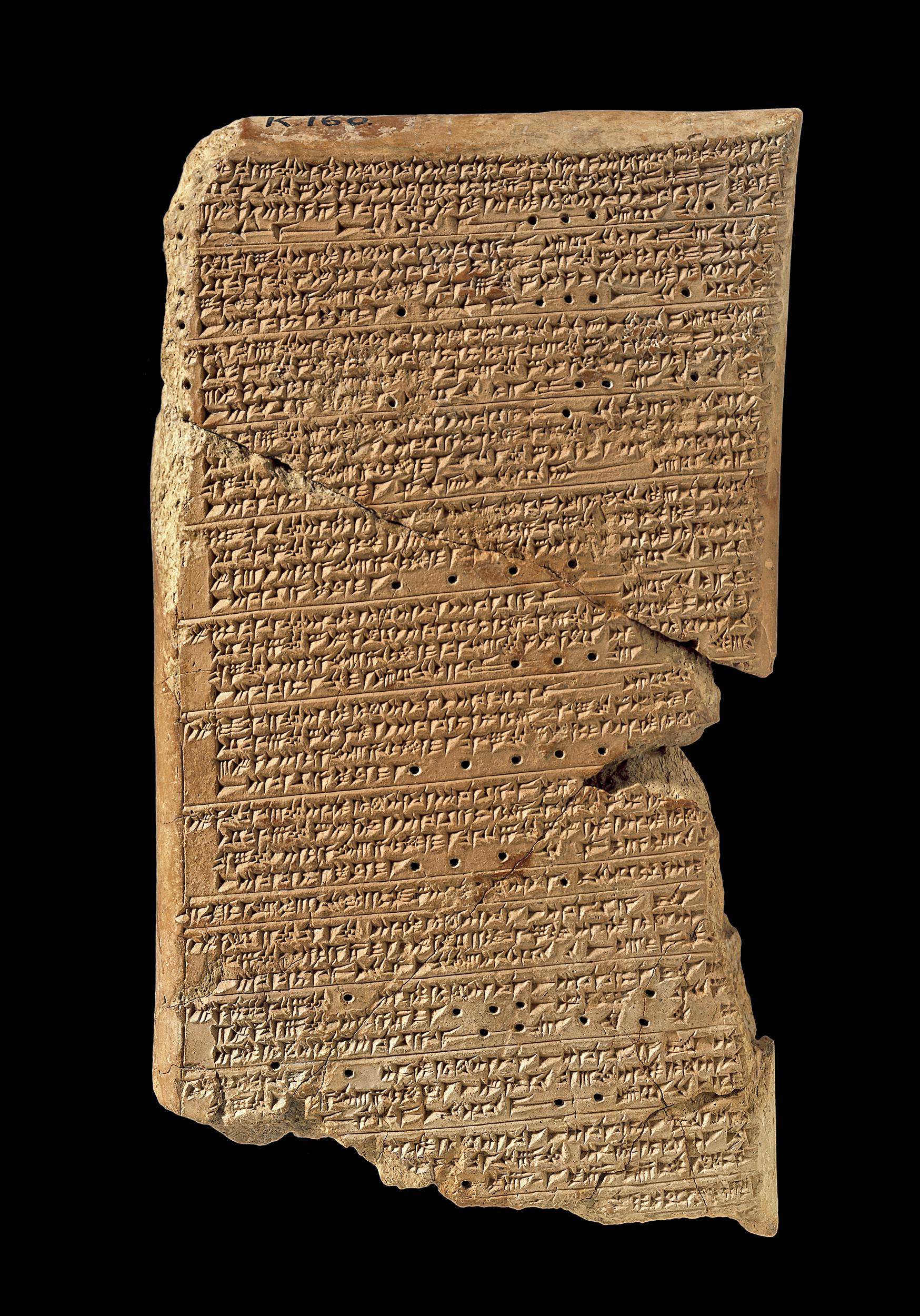
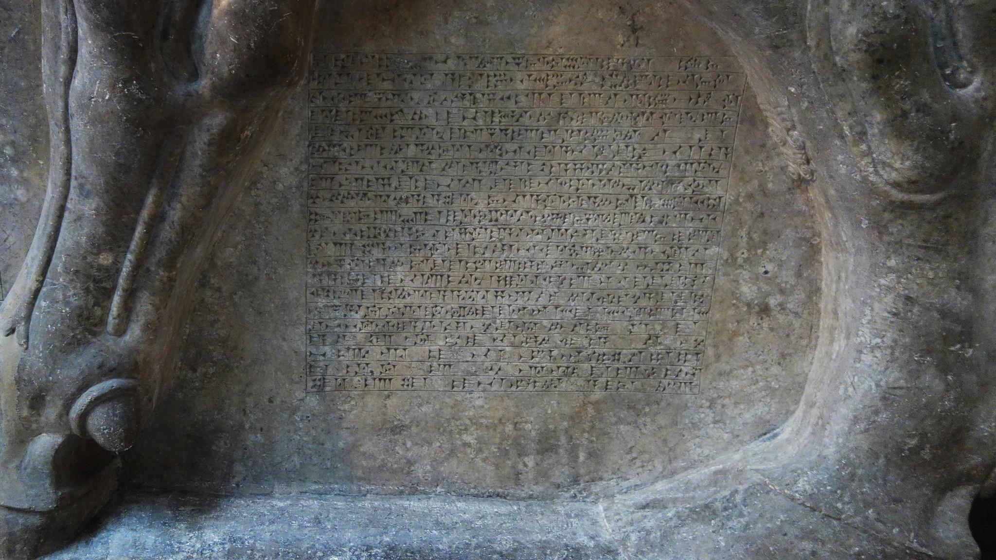
Cuneiform is one of the oldest forms of writing known. It means “wedge-shaped,” because people wrote it using a reed stylus cut to make a wedge-shaped mark on a clay tablet. Letters enclosed in clay envelopes, as well as works of literature, such as the Epic of Gilgamesh have been found. Historical accounts have also come to light, as have huge libraries such as that belonging to the Assyrian king, Ashurbanipal. Cuneiform writing was used to record a variety of information such as temple activities, business, and trade. Cuneiform was also used to write stories, myths, and personal letters. The latest known example of cuneiform is an astronomical text from 75 C.E. During its 3,000-year history, cuneiform was used to write around 15 different languages including Sumerian, Akkadian, Babylonian, Assyrian, Elamite, Hittite, Urartian, and Old Persian.
Cuneiform tablets at the British Museum
The department’s collection of cuneiform tablets is among the most important in the world. It contains approximately 130,000 texts and fragments and is perhaps the largest collection outside of Iraq. The centerpiece of the collection is the Library of Ashurbanipal, comprising many thousands of the most important tablets ever found. The significance of these tablets was immediately realized by the Library’s excavator, Austin Henry Layard, who wrote:
They furnish us with materials for the complete decipherment of the cuneiform character, for restoring the language and history of Assyria, and for inquiring into the customs, sciences, and . . . literature, of its people.
The Library of Ashurbanipal is the oldest surviving royal library in the world. British Museum archaeologists discovered more than 30,000 cuneiform tablets and fragments at his capital, Nineveh (modern Kuyunjik). Alongside historical inscriptions, letters, and administrative and legal texts, were found thousands of divinatory, magical, medical, literary and lexical texts. This treasure-house of learning has held unparalleled importance to the modern study of the ancient Near East ever since the first fragments were excavated in the 1850s.
The best known piece of literature from ancient Mesopotamia is the story of Gilgamesh, a legendary ruler of Uruk, and his search for immortality. The Epic of Gilgamesh is a huge work, the longest piece of literature in Akkadian (the language of Babylonia and Assyria). It was known across the ancient Near East, with versions also found at Hattusas (capital of the Hittites), Emar in Syria, and Megiddo in the Levant.
This, the eleventh tablet of the Epic, describes the meeting of Gilgamesh with Utnapishtim. Like Noah in the Hebrew Bible, Utnapishtim had been forewarned of a plan by the gods to send a great flood. He built a boat and loaded it with all his precious possessions, his kith and kin, domesticated and wild animals and skilled craftsmen of every kind.
Utnapishtim survived the flood for six days while mankind was destroyed, before landing on a mountain called Nimush. He released a dove and a swallow but they did not find dry land to rest on, and returned. Finally a raven that he released did not return, showing that the waters must have receded.
This Assyrian version of the Old Testament flood story is the most famous cuneiform tablet from Mesopotamia. It was identified in 1872 by George Smith, an assistant in The British Museum. On reading the text “he … jumped up and rushed about the room in a great state of excitement, and, to the astonishment of those present, began to undress himself.”
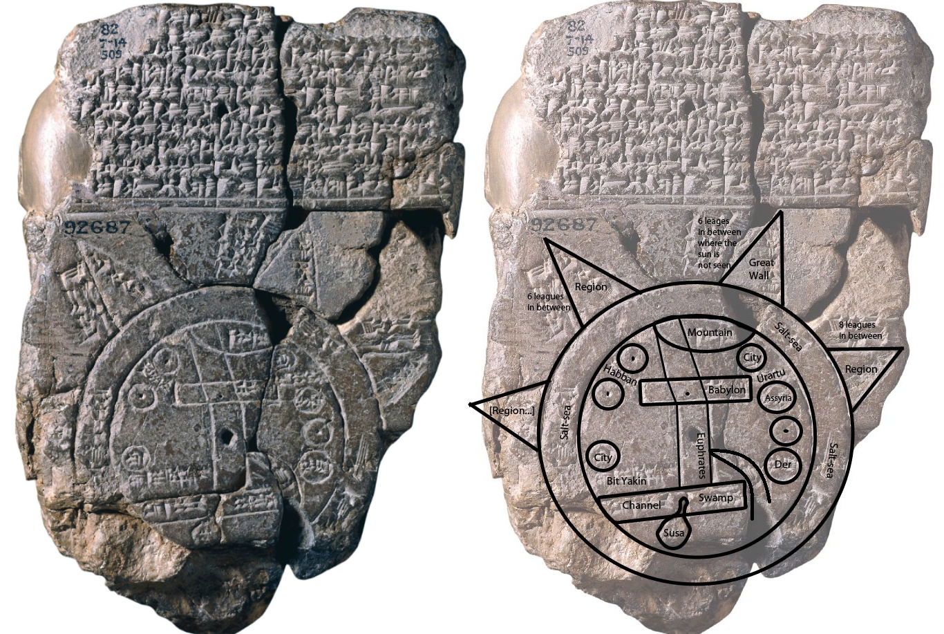
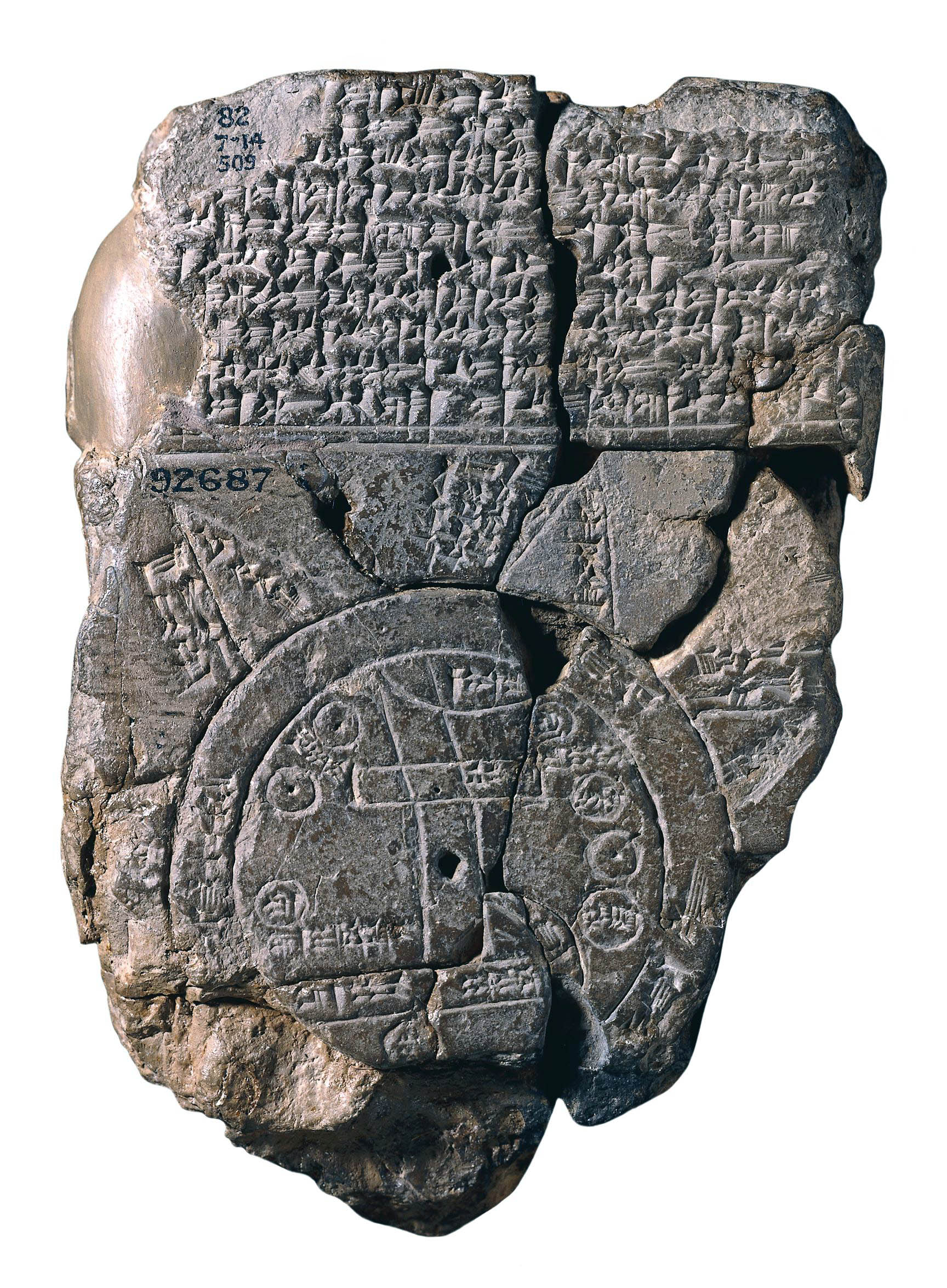
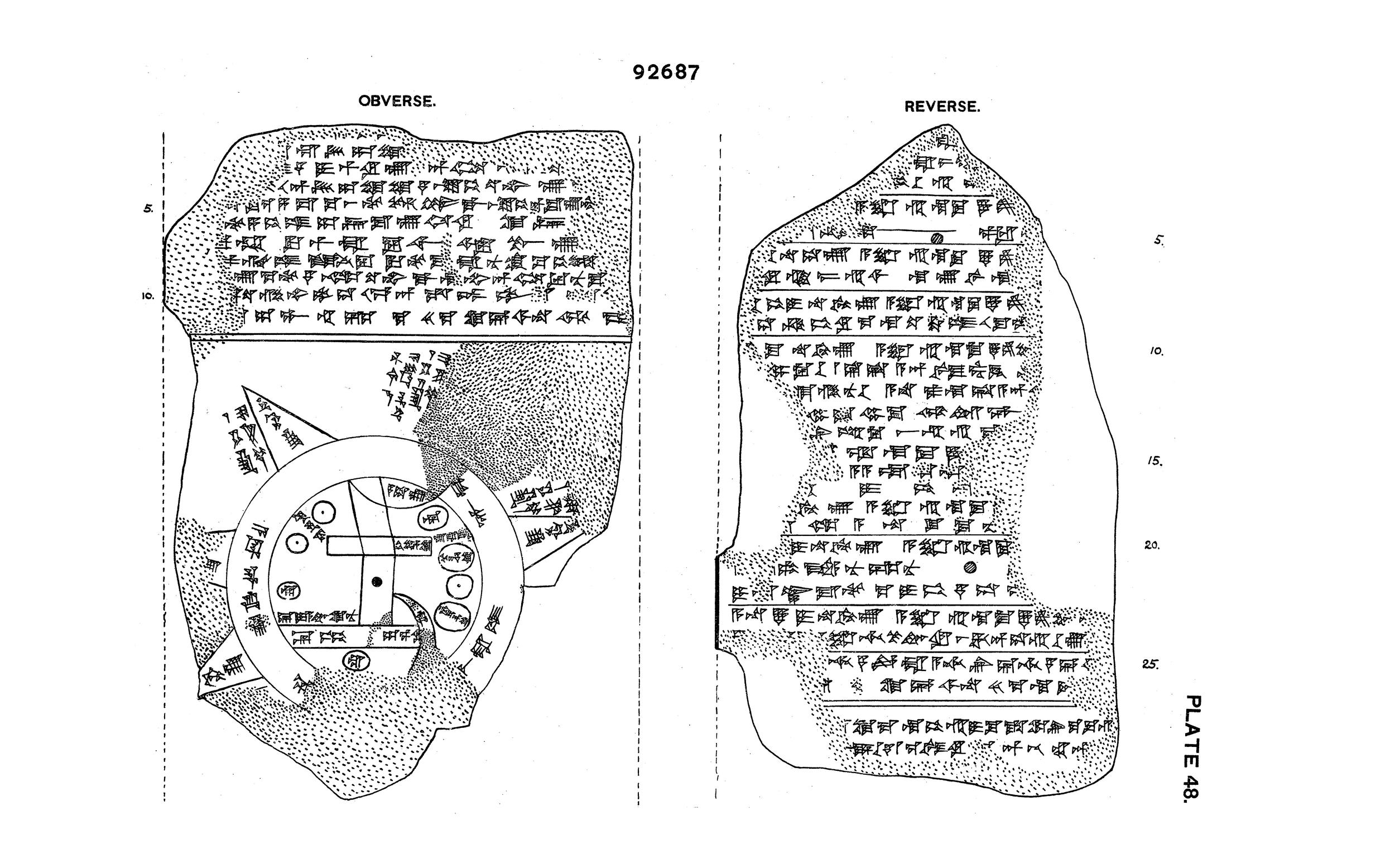
This tablet contains both a cuneiform inscription and a unique map of the Mesopotamian world. Babylon is shown in the center (the rectangle in the top half of the circle), and Assyria, Elam, and other places are also named.
The central area is ringed by a circular waterway labelled “Salt-Sea.” The outer rim of the sea is surrounded by what were probably originally eight regions, each indicated by a triangle, labelled “Region” or “Island,” and marked with the distance in between. The cuneiform text describes these regions, and it seems that strange and mythical beasts as well as great heroes lived there, although the text is far from complete. The regions are shown as triangles since that was how it was visualized that they first would look when approached by water.
The map is sometimes taken as a serious example of ancient geography, but although the places are shown in their approximately correct positions, the real purpose of the map is to explain the Babylonian view of the mythological world.
Observations of Venus
Thanks to Assyrian records, the chronology of Mesopotamia is relatively clear back to around 1200 B.C.E. However, before this time dating is less certain.
This tablet is one of the most important (and controversial) cuneiform tablets for reconstructing Mesopotamian chronology before around 1400 B.C.E.
The text of the tablet is a copy, made at Nineveh in the seventh century B.C.E., of observations of the planet Venus made in the reign of Ammisaduqa, king of Babylon, about 1000 years earlier. Modern astronomers have used the details of the observations in an attempt to calculate the dates of Ammisaduqa. Ideally this process would also allow us to date the Babylonian rulers of the early second and late third millennium B.C.E. Unfortunately, however, there is much uncertainty in the dating because the records are so inconsistent. This has led to different chronologies being adopted with some scholars favoring a “high” chronology while others adopt a “middle” or “low” range of dates. There are good arguments for each of these.
Scribes
Literacy was not widespread in Mesopotamia. Scribes, nearly always men, had to undergo training, and having successfully completed a curriculum became entitled to call themselves dubsar, which means “scribe.” They became members of a privileged élite who, like scribes in ancient Egypt, might look with contempt upon their fellow citizens.
Understanding of life in Babylonian schools is based on a group of Sumerian texts of the Old Babylonian period. These texts became part of the curriculum and were still being copied a thousand years later. Schooling began at an early age in the é-dubba, the “tablet house.” Although the house had a headmaster, his assistant, and a clerk, much of the initial instruction and discipline seems to have been in the hands of an elder student—the scholar’s “big brother.” All these had to be flattered or bribed with gifts from time to time to avoid a beating.
Apart from mathematics, the Babylonian scribal education concentrated on learning to write Sumerian and Akkadian using cuneiform and on learning the conventions for writing letters, contracts, and accounts. Scribes were under the patronage of the Sumerian goddess Nisaba. In later times her place was taken by the god Nabu, whose symbol was the stylus (a cut reed used to make signs in damp clay).
Deciphering cuneiform
The decipherment of cuneiform began in the eighteenth century as European scholars searched for proof of the places and events recorded in the Bible. Travelers, antiquaries, and some of the earliest archaeologists visited the ancient Near East where they uncovered great cities such as Nineveh. They brought back a range of artifacts, including thousands of clay tablets covered in cuneiform.
Scholars began the incredibly difficult job of trying to decipher these strange signs representing languages no-one had heard for thousands of years. Gradually the cuneiform signs representing these different languages were deciphered thanks to the work of a number of dedicated people.
Confirmation that they had succeeded came in 1857. The Royal Asiatic Society sent copies of a newly found clay record of the military and hunting achievements of King Tiglath-pileser I to four scholars: Henry Creswicke Rawlinson, Edward Hincks, Julius Oppert, and William H. Fox Talbot. They each worked independently and returned translations that broadly agreed with each other.
This was accepted as proof that cuneiform had been successfully deciphered, but there are still elements that we don’t completely understand and the study continues. What we have been able to read, however, has opened up the ancient world of Mesopotamia. It has not only revealed information about trade, building, and government, but also great works of literature, history, and everyday life in the region.
Source: The British Museum, “Cuneiform, an introduction,” in Smarthistory, February 28, 2017, accessed August 21, 2024, https://smarthistory.org/cuneiform/.
Writing Cuneiform
by THE BRITISH MUSEUM
Unlike modern writing, cuneiform wasn’t written in ink—but was instead pressed into the surface of clay.
Cuneiform tablets are among the most plentiful types of ancient artifacts in the world: over half a million are thought to be held in museum collections, and thousands, or perhaps millions, more have yet to be excavated. These artifacts are a rich part of global heritage, allowing researchers to learn vital information about the societies that produced them. Such information is even more valuable when objects are properly excavated, with documented findspots that allow experts to analyze not just their content, but their physical and cultural context.
With the escalation of conflict in the Middle East, opportunities for the looting and illegal sale of objects like these have greatly increased. Private dealers, as well as militant groups like ISIS, are benefitting from the lack of security in countries like Iraq, where it is relatively easy to find and remove archaeologically-significant objects and sell them on the black market.
However, such sales are not possible without buyers to drive demand. A prominent example of this is the recent case brought against the Green family, the owners of the Oklahoma-based Hobby Lobby chain of retail stores. In 2010 and 2011, U.S. Customs and Border Control intercepted several packages addressed to the company. They were marked as “tile samples” and documented as coming from Turkey, but they actually contained over 5,500 cuneiform tablets and bricks, clay bullae, and cylinder seals thought to be from Iraq. The Green family—noted collectors of objects associated with the Biblical Middle East—had paid $1.6 million to a private dealer in exchange for the shipments. They agreed to forfeit the objects and pay a fine of $3 million to the Department of Justice.
The looting and illegal sale of important historical artifacts is detrimental to global cultural heritage for many reasons: it impedes research, divorces objects from their historical context, and robs at-risk communities of their rightful cultural property. The case of Hobby Lobby highlights the importance of policing such trafficking not just in the places where artifacts are found, but also in the places where they are collected and purchased.
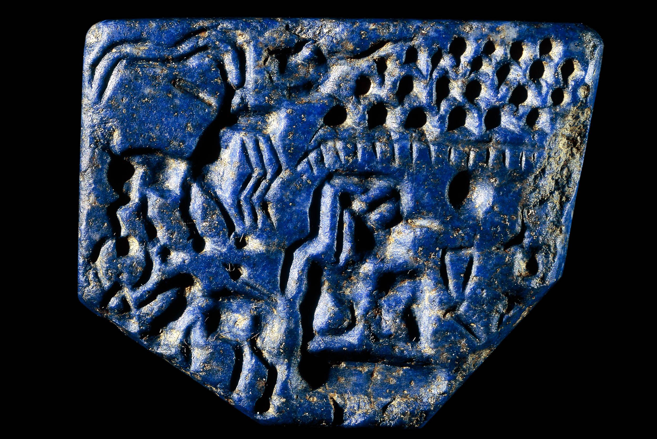
This stamp seal was originally almost square, but because of damage one corner is missing. Originally two figures faced each other. The one on the left has largely disappeared. On the right is a man with his legs folded beneath him. It is suggested that at the top are rain clouds and rain or a fenced enclosure. Behind the man are a long-horned goat above a zebu. This last animal is related in style to similar creatures depicted on seals from the Indus Valley civilization, which was thriving at this time. There were close connections between the Indus Valley civilization and eastern Iran.
One of the prized materials that was traded across the region was lapis lazuli, the blue stone from which this seal is made. The Sar-i Sang mines in the region of Badakhshan in north-east Afghanistan were probably the source for all lapis lazuli used in the ancient Near East. From here it was carried across Iran, where several lapis working sites have been discovered, and on to Mesopotamia and Egypt. Another source for lapis lazuli exists in southern Pakistan (a region of the Indus Valley civilization) but it is unclear if they were mined at the time of this seal.
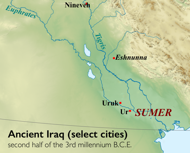
The region of southern Mesopotamia is known as Sumer, and it is in Sumer that we find some of the oldest known cities, including Ur and Uruk.
Uruk
Prehistory ends with Uruk, where we find some of the earliest written records. This large city-state (and it environs) was largely dedicated to agriculture and eventually dominated southern Mesopotamia. Uruk perfected Mesopotamian irrigation and administration systems.
An agricultural theocracy
Within the city of Uruk, there was a large temple complex dedicated to Innana, the patron goddess of the city. The City-State’s agricultural production would be “given” to her and stored at her temple. Harvested crops would then be processed (grain ground into flour, barley fermented into beer) and given back to the citizens of Uruk in equal share at regular intervals.
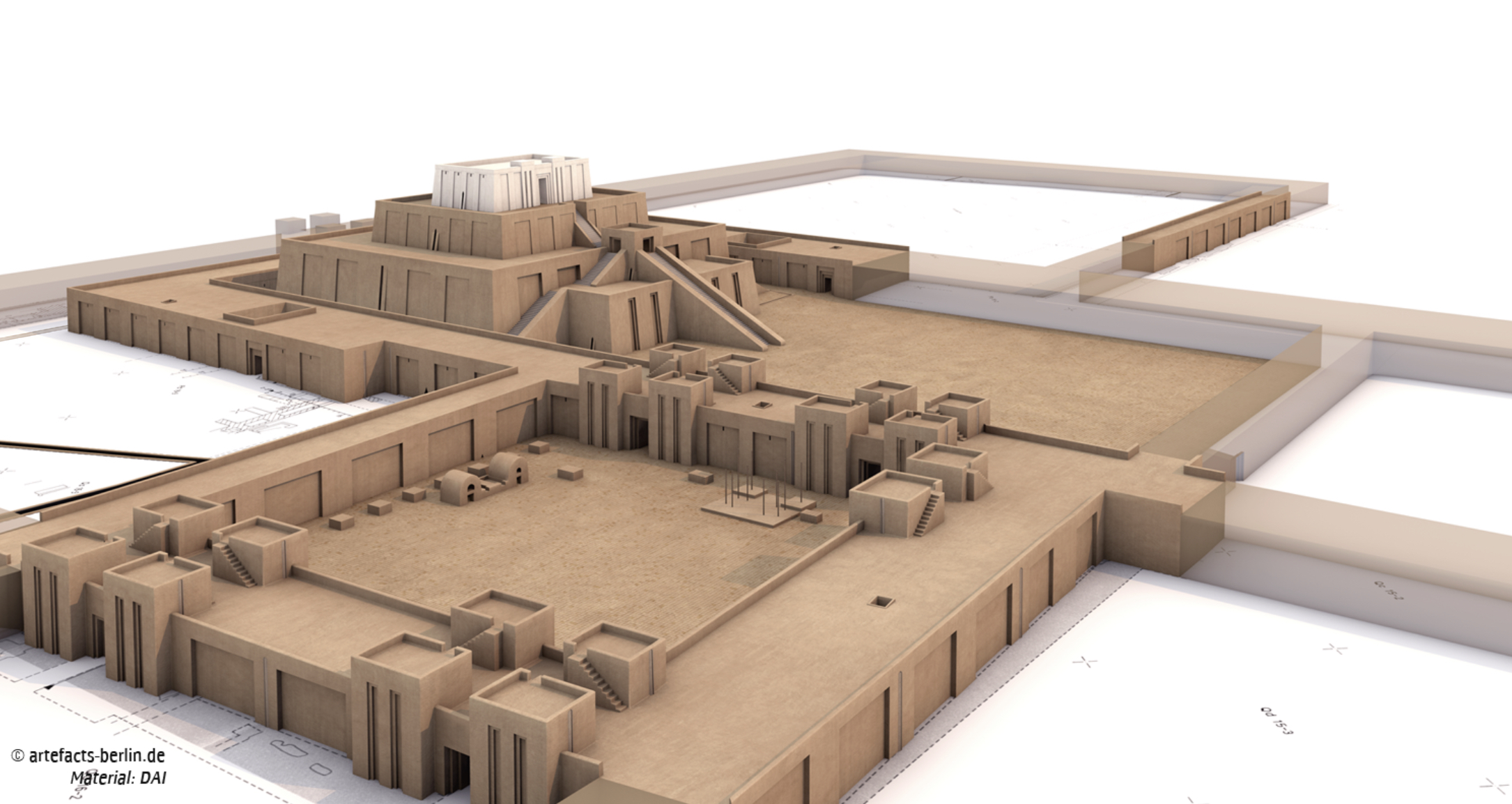
Reconstruction of the ziggurat at Uruk dedicated to the goddess Inanna (created by Artefacts/DAI, copyright DAI, CC-BY-NC-ND)
The head of the temple administration, the chief priest of Innana, also served as political leader, making Uruk the first known theocracy. We know many details about this theocratic administration because the Sumerians left numerous documents in the form of tablets written in cuneiform script.
It is almost impossible to imagine a time before writing. However, you might be disappointed to learn that writing was not invented to record stories, poetry, or prayers to a god. The first fully developed written script, cuneiform, was invented to account for something unglamorous, but very important—surplus commodities: bushels of barley, head of cattle, and jars of oil!
The origin of written language (c. 3200 B.C.E.) was born out of economic necessity and was a tool of the theocratic (priestly) ruling elite who needed to keep track of the agricultural wealth of the city-states. The last known document written in the cuneiform script dates to the first century C.E. Only the hieroglyphic script of the Ancient Egyptians lasted longer.
A reed and clay tablet
A single reed, cleanly cut from the banks of the Euphrates or Tigris river, when pressed cut-edge down into a soft clay tablet, will make a wedge shape. The arrangement of multiple wedge shapes (as few as two and as many as ten) created cuneiform characters. Characters could be written either horizontally or vertically, although a horizontal arrangement was more widely used.
Very few cuneiform signs have only one meaning; most have as many as four. Cuneiform signs could represent a whole word or an idea or a number. Most frequently though, they represented a syllable. A cuneiform syllable could be a vowel alone, a consonant plus a vowel, a vowel plus a consonant and even a consonant plus a vowel plus a consonant. There isn’t a sound that a human mouth can make that this script can’t record.
Probably because of this extraordinary flexibility, the range of languages that were written with cuneiform across history of the Ancient Near East is vast and includes Sumerian, Akkadian, Amorite, Hurrian, Urartian, Hittite, Luwian, Palaic, Hatian, and Elamite.
Sumerian Architecture
White Temple and ziggurat, Uruk
by DR. SENTA GERMAN
A gleaming temple built atop a mud-brick platform, it towered above the flat plain of Uruk.
Archaeological site at Uruk (modern Warka) in Iraq (photo: SAC Andy Holmes (RAF)/MOD, Open Government Licence v1.0)
Visible from a great distance
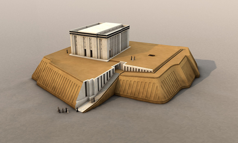
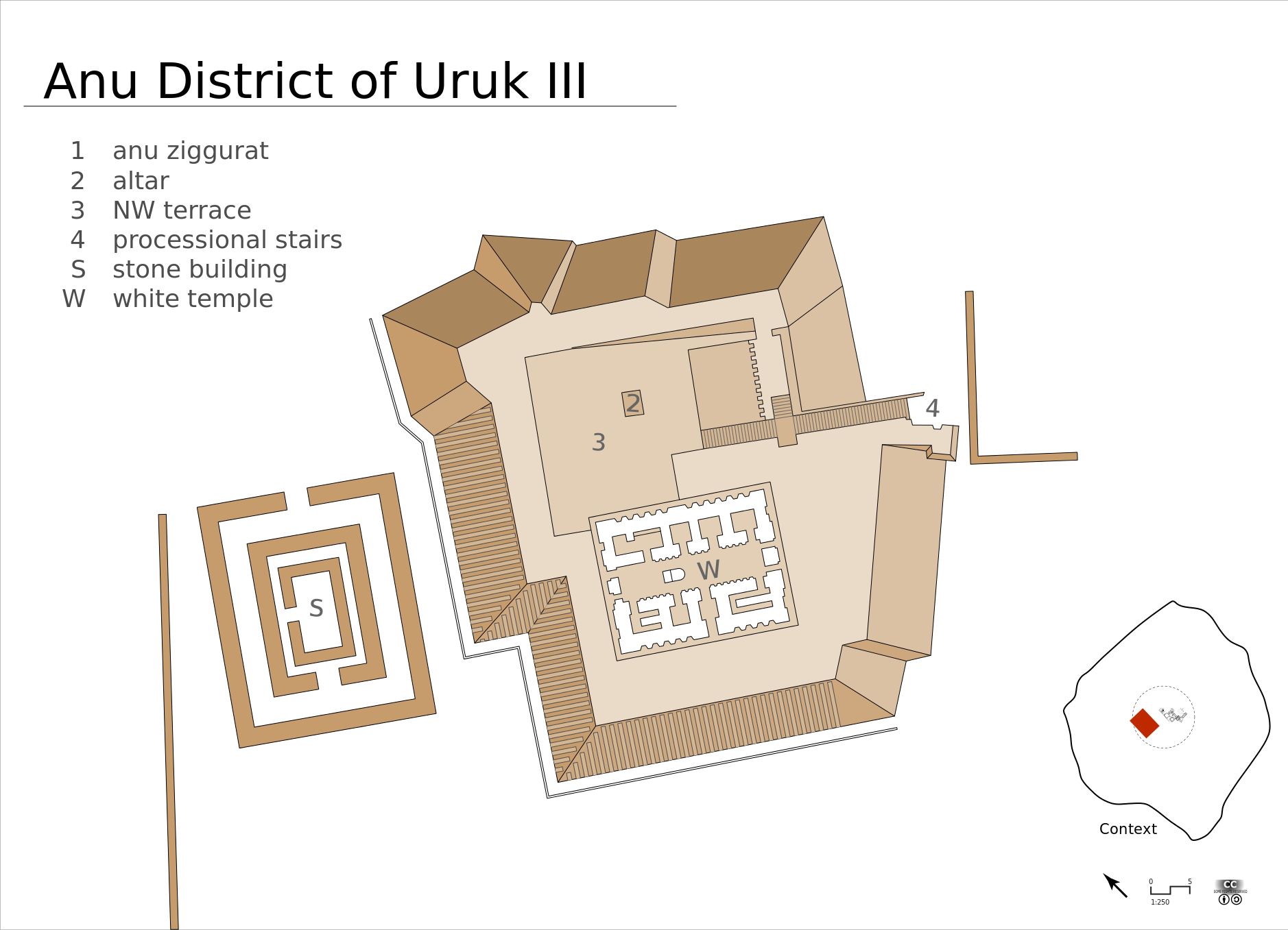
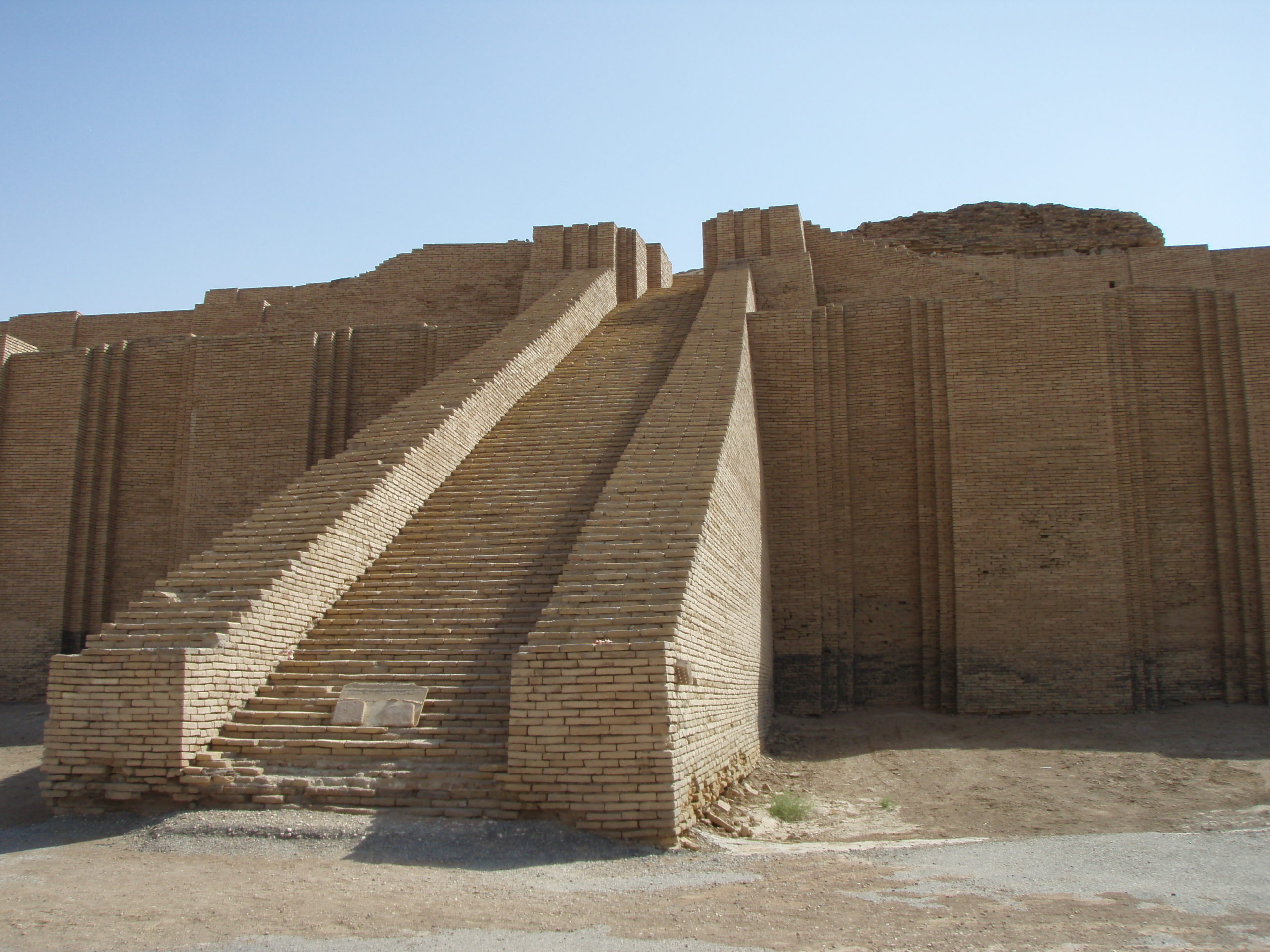
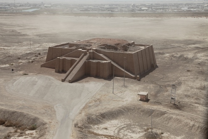
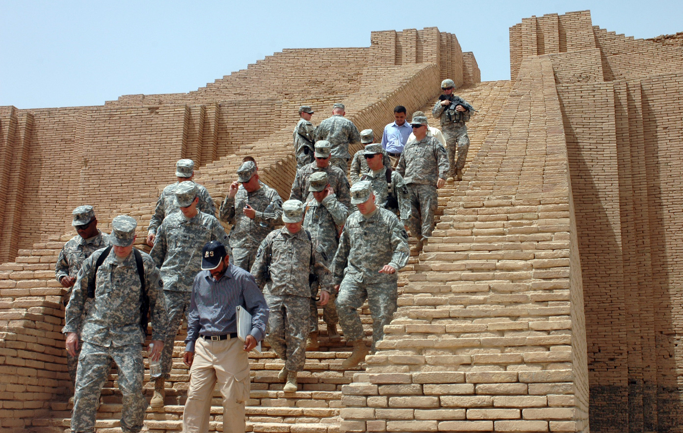
Uruk (modern Warka in Iraq)—where city life began more than five thousand years ago and where the first writing emerged—was clearly one of the most important places in southern Mesopotamia. Within Uruk, the greatest monument was the Anu Ziggurat on which the White Temple was built. Dating to the late 4th millennium B.C.E. (the Late Uruk Period, or Uruk III) and dedicated to the sky god Anu, this temple would have towered well above (approximately 40 feet) the flat plain of Uruk, and been visible from a great distance—even over the defensive walls of the city.
A ziggurat is a built raised platform with four sloping sides—like a chopped-off pyramid. Ziggurats are made of mud-bricks—the building material of choice in the Near East, as stone is rare. Ziggurats were not only a visual focal point of the city, they were a symbolic one, as well—they were at the heart of the theocratic political system (a theocracy is a type of government where a god is recognized as the ruler, and the state officials operate on the god’s behalf). So, seeing the ziggurat towering above the city, one made a visual connection to the god or goddess honored there, but also recognized that deity’s political authority.
Remains of the Anu Ziggurat, Uruk (modern Warka), c. 3517–3358 B.C.E. (photo: Geoff Emberling, by permission)
Excavators of the White Temple estimate that it would have taken 1500 laborers working on average ten hours per day for about five years to build the last major revetment (stone facing) of its massive underlying terrace (the open areas surrounding the White Temple at the top of the ziggurat). Although religious belief may have inspired participation in such a project, no doubt some sort of force (corvée labor—unpaid labor coerced by the state/slavery) was involved as well.
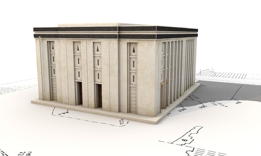
The sides of the ziggurat were very broad and sloping but broken up by recessed stripes or bands from top to bottom (see digital reconstruction, above), which would have made a stunning pattern in morning or afternoon sunlight. The only way up to the top of the ziggurat was via a steep stairway that led to a ramp that wrapped around the north end of the Ziggurat and brought one to the temple entrance. The flat top of the ziggurat was coated with bitumen (asphalt—a tar or pitch-like material similar to what is used for road paving) and overlaid with brick, for a firm and waterproof foundation for the White temple. The temple gets its name for the fact that it was entirely white washed inside and out, which would have given it a dazzling brightness in strong sunlight.
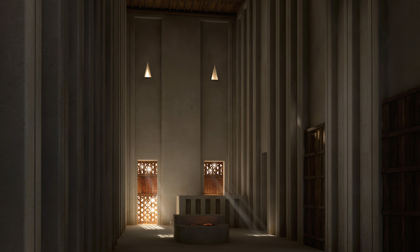
The White temple was rectangular, measuring 17.5 x 22.3 meters and, at its corners, oriented to the cardinal points. It is a typical Uruk “high temple (Hochtempel)” type with a tripartite plan: a long rectangular central hall with rooms on either side (see plan below). The White Temple had three entrances, none of which faced the ziggurat ramp directly. Visitors would have needed to walk around the temple, appreciating its bright façade and the powerful view, and likely gained access to the interior in a “bent axis” approach (where one would have to turn 90 degrees to face the altar), a typical arrangement for Ancient Near Eastern temples.
The north west and east corner chambers of the building contained staircases (unfinished in the case of the one at the north end). Chambers in the middle of the northeast room suite appear to have been equipped with wooden shelves in the walls and displayed cavities for setting in pivot stones which might imply a solid door was fitted in these spaces. The north end of the central hall had a podium accessible by means of a small staircase and an altar with a fire-stained surface. Very few objects were found inside the White Temple, although what has been found is very interesting. Archaeologists uncovered some 19 tablets of gypsum on the floor of the temple—all of which had cylinder seal impressions and reflected temple accounting. Also, archaeologists uncovered a foundation deposit of the bones of a leopard and a lion in the eastern corner of the Temple (foundation deposits, ritually buried objects and bones, are not uncommon in ancient architecture).
To the north of the White Temple there was a broad flat terrace, at the center of which archaeologists found a huge pit with traces of fire (2.2 x 2.7m) and a loop cut from a massive boulder. Most interestingly, a system of shallow bitumen-coated conduits were discovered. These ran from the southeast and southwest of the terrace edges and entered the temple through the southeast and southwest doors. Archaeologists conjecture that liquids would have flowed from the terrace to collect in a pit in the center hall of the temple.
Anu District Phase E, reconstruction: Lamassu Design (Gurdjieff, CC BY-SA 3.0)
Archaeological reconstructions
by SEBASTIAN HAGENEUER
Reconstructions of ancient sites or finds can help us to understand the distant past. For non-academics, reconstructions offer a glimpse into that past, a kind of visual accumulation of scientific research communicated by means of images, models or even virtual reality. We see reconstructions in films, museums and magazines to illustrate the stories behind the historical or archaeological facts. For archaeologists like me however, reconstructions are also an important tool to answer unsolved questions and even raise new ones. One field where this is particularly true is the reconstruction of ancient architecture.
Early reconstructions
Since at least medieval times, artists created visual reconstructions drawn from the accounts of travelers or the Bible. Examples of this include the site of Stonehenge or the Tower of Babylon. Since the beginning of archaeology as a science in the mid-19th century, scientific reconstructions based on actual data were made. Of course, the earlier visualizations were more conjectural than later ones, due to the lack of comparable data at that time (for example, the image below).
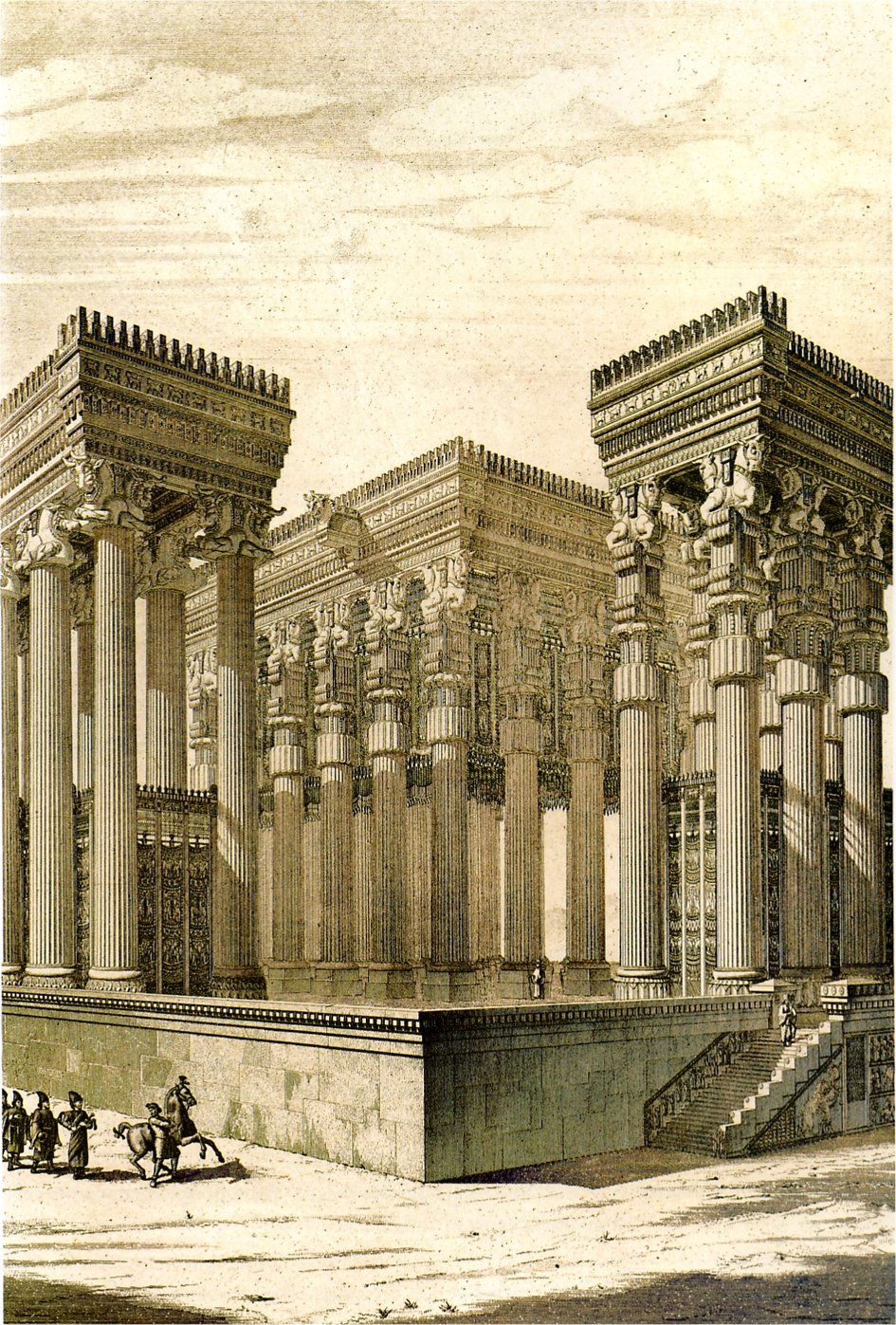
Reconstruction drawing of Nimrud, the site of an ancient Assyrian palace, by James Fergusson for Sir Henry Layard, published in 1853. The columns depicted here were never found. The reconstruction is clearly influenced by what was known at that time of Greco-Roman architecture and by John Martin’s Fall of Nineveh (1829)
The three building blocks of reconstructions
Since the end of the 19th century, reconstruction drawings evolved to be less conjectural and increasingly based on actual archaeological data as these became available due to increased excavations. Today we can not only look at reconstructions, we can experience them—whether as life-sized physical models or as immersive virtual simulations. But how do we create them? What are they made of? Every reconstruction is basically composed of three building blocks: Primary Sources, Secondary Sources, and Guesswork.
The first step toward a good visualization is to become aware of the archaeological data, the excavated remains—simply everything that has survived. This data is referred to as the Primary Sources—this is the part of the reconstruction we are most certain about. Sometimes we have a lot that survives and sometimes we only have the basic layout of a ground plan (below).
Even when the Primary Sources are utilized, we often have to fill the gaps with Secondary Sources. These sources are composed of architectural parallels, ancient depictions and descriptions, or ethno-archaeological data. So, for example in the case of the Building C in Uruk (above), we know through Primary Sources, that this building was made of mud-bricks (at least the first two rows). We then have to look at other buildings of that time to find out how they were built. In the example above, the layout of the ground-plan shows us that this building was tripartite—a layout well known from this and other sites. We also look at contemporary architecture to understand how mud-brick architecture functions and to find out what certain architectural details might mean. Unfortunately, we don’t have any depictions or textual evidence that can help us with this example. Parallels from later times however show us that the unusual niches in the rooms suggest an important function.
After utilising all the primary and secondary sources, we still need to fill in the gaps. The third part of every reconstruction is simple Guesswork. We obviously need to limit that part as much as we can, but there is always some guesswork involved—no matter how much we research our building. For example, it is rather difficult to decide how high Building C was over 5000 years ago. We therefore have to make an educated guess based, for example, on the estimated length and inclination of staircases within the building. If we are lucky, we can use some primary or secondary sources for that too, but even then, in the end we need to make a subjective decision.
Besides creating these reconstructions to display them in exhibitions, architectural models can also aid archaeological investigations. If we construct ancient architecture using the computer, we not only need to decide every aspect of that particular building, but also the relation to adjoining architecture. Sometimes, the process of reconstructing several buildings and thinking about their interdependence can reveal interesting connections, for example the complicated matter of water disposal off a roof.
These are only random examples, but clearly, the process of architectural reconstruction is a complex one. We, as the creators, need to make sure that the observer understands the problems and uncertainties of a particular reconstruction. It is essential that the viewer understands that these images are not 100% factual. As the archaeologist Simon James has put it: “Every reconstruction is wrong. The only real question is, how wrong is it?”
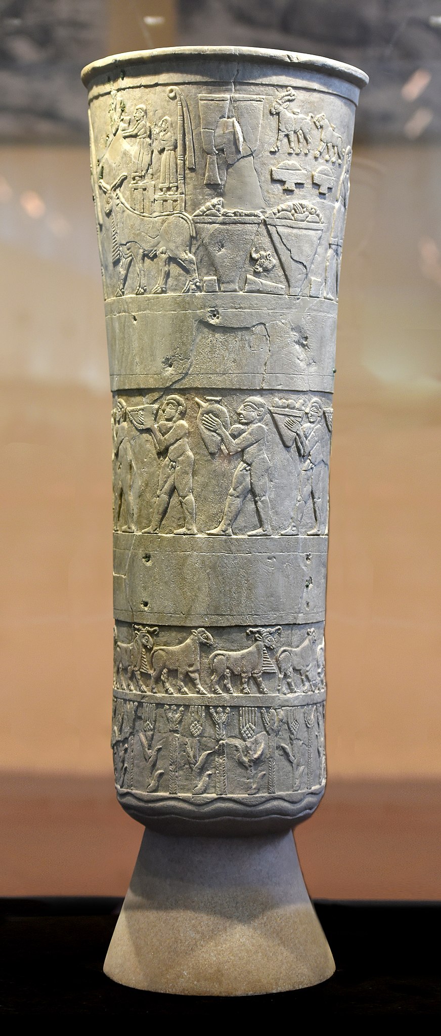
Sumerian Sculpture
The Warka Vase work gives us a good idea of the standardization of compositional “rules” in relief sculpture. The surface is organized into registers (horizontal bands or rows), the figures are placed on a groundline and the bodies are stylized – they are shown in composite pose (a combination of profile heads and legs with three-quarter view torsos. The eyes are depicted frontally. The most important figures are on the top register and are larger than the others, which is known as hierarchical scale.
Warka Vase
by DR. SENTA GERMAN
One of the most precious artifacts from Sumer, the Warka Vase was looted and almost lost forever.
Warka (Uruk) Vase, Uruk, Late Uruk period, c. 3500–3000 B.C.E., 105 cm high (National Museum of Iraq; photo: Osama Shukir Muhammed Amin FRCP(Glasg), CC BY-SA 4.0)
Picturing the ruler
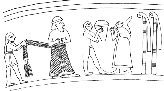
So many important innovations and inventions emerged in the Ancient Near East during the Uruk period. One of these was the use of art to illustrate the role of the ruler and his place in society. The Warka Vase, c. 3000 B.C.E., was discovered at Uruk (Warka is the modern name, Uruk the ancient name), and is probably the most famous example of this innovation. In its decoration we find an example of the cosmology of ancient Mesopotamia.
The vase, made of alabaster and standing over three feet high (just about a meter) and weighing some 600 pounds (about 270 kg), was discovered in 1934 by German excavators working at Uruk in a ritual deposit in the temple of Inanna, the goddess of love, fertility, and war and the main patron of the city of Uruk. It was one of a pair of vases found in the Inanna temple complex (but the only one on which the image was still legible) together with other valuable objects.
Bottom bands (detail), Warka (Uruk) Vase, Uruk, Late Uruk period, c. 3500–3000 B.C.E., 105 cm high (National Museum of Iraq; photo: Osama Shukir Muhammed Amin FRCP(Glasg), CC BY-SA 4.0)
Given the significant size of the Warka Vase, where it was found, the precious material from which it is carved and the complexity of its relief decoration, it was clearly of monumental importance, something to be admired and valued. Though known since its excavation as the Warka “Vase,” that term does little to express the sacredness of this object for the people who lived in Uruk five thousand years ago.
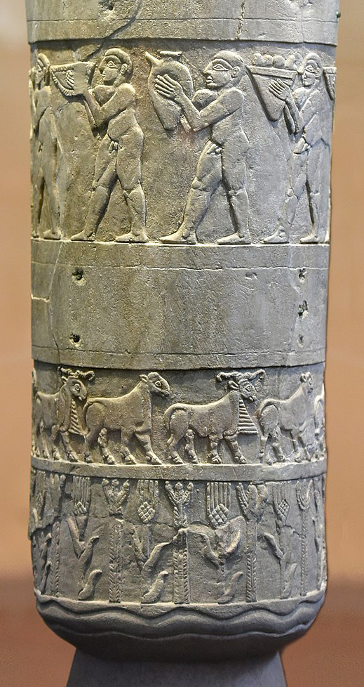
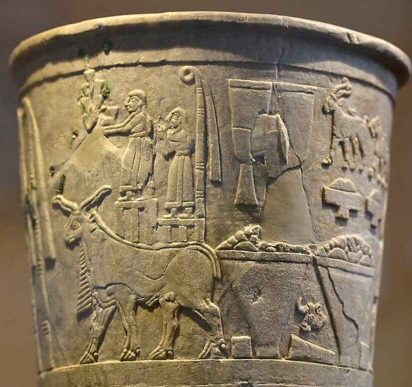
The relief carvings on the exterior of the vase run around its circumference in four parallel bands (or registers, as art historians like to call them) and develop in complexity from the bottom to the top.
Beginning at the bottom, we see a pair of wavy lines from which grow neatly alternating plants that appear to be grain (probably barley) and reeds, the two most important agricultural harvests of the Tigris and Euphrates rivers in southern Mesopotamia. There is a satisfying rhythm to this alternation, and one that is echoed in the rhythm of the rams and ewes (male and female sheep) that alternate in the band above this. The sheep march to the right in tight formation, as if being herded—the method of tending this important livestock in the agrarian economy of the Uruk period.
The band above the sheep is a blank and might have featured painted decoration that has since faded away. Above this blank band, a group of nine identical men march to the left. Each holds a vessel in front of his face, and which appear to contain the products of the Mesopotamian agricultural system: fruits, grains, wine, and mead. The men are all naked and muscular and, like the sheep beneath them, are closely and evenly grouped, creating a sense of rhythmic activity. Nude figures in Ancient Near Eastern art are meant to be understood as humble and low status, so we can assume that these men are servants or enslaved individuals (the band above, displays the owners of the enslaved figures).
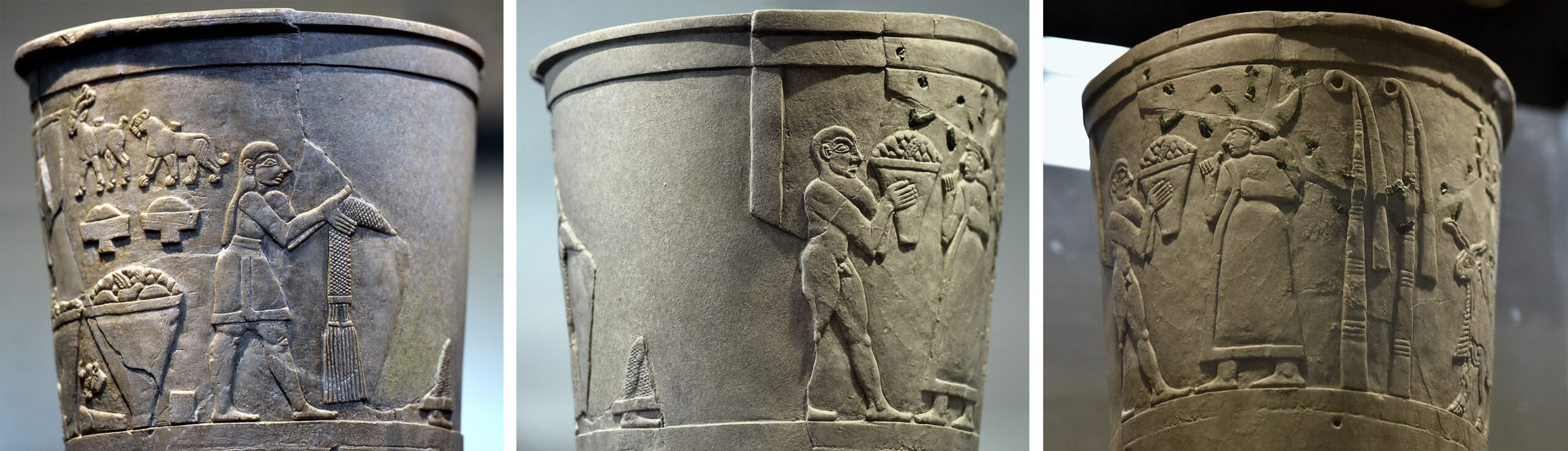
Top band (details), Warka (Uruk) Vase, Uruk, Late Uruk period, c. 3500–3000 B.C.E., 105 cm high (National Museum of Iraq; left photo: Osama Shukir Muhammed Amin FRCP(Glasg), CC BY-SA 4.0; middle photo: Osama Shukir Muhammed Amin FRCP(Glasg), CC BY-SA 4.0; right photo: Osama Shukir Muhammed Amin FRCP(Glasg), CC BY-SA 4.0)
Drawing, top register, Warka (Uruk) Vase (reconstructing some missing areas), by Jo Wood, after M. Roaf, from Leaving No Stones Unturned: Essays on the Ancient Near East and Egypt in Honor of Donald P. Hansen (Eisenbrauns, 2001), p. 17.
The top band of the vase is the largest, most complex, and least straightforward. It has suffered some damage but enough remains that the scene can be read. The center of the scene appears to depict a man and a woman who face each other. A smaller naked male stands between them holding a container of what looks like agricultural produce which he offers to the woman. The woman, identified as such by her robe and long hair, at one point had an elaborate crown on her head (this piece was broken off and repaired in antiquity).
Behind her are two reed bundles, symbols of the goddess Inanna, whom, it is assumed, the woman represents. The man she faces is nearly entirely broken off, and we are left with only the bottom of his long garment. However, men with similar robes are often found in contemporary seal stone engraving and based upon these, we can reconstruct him as a king with a long skirt, a beard and a head band. The tassels of his skirt are held by another smaller scaled man behind him, a steward or attendant to the king, who wears a short skirt.
Top band (detail), Warka (Uruk) Vase, Uruk, Late Uruk period, c. 3500–3000 B.C.E., 105 cm high (National Museum of Iraq; photo: Osama Shukir Muhammed Amin FRCP(Glasg), CC BY-SA 4.0)
The rest of the scene is found behind the reed bundles at the back of Inanna. There we find two-horned and bearded rams (one directly behind the other, so the fact that there are two can only be seen by looking at the hooves) carrying platforms on their backs on which statues stand. The statue on the left carries the cuneiform sign for EN, the Sumerian word for chief priest. The statue on the right stands before yet another Inanna reed bundle. Behind the rams is an array of tribute gifts including two large vases which look quite a lot like the Warka Vase itself.
What could this busy scene mean? The simplest way to interpret it is that a king (presumably of Uruk) is celebrating Inanna, the city’s most important divine patron. A more detailed reading of the scene suggests a sacred marriage between the king, acting as the chief priest of the temple, and the goddess—each represented in person as well as in statues. Their union would guarantee for Uruk the agricultural abundance we see depicted behind the rams. The worship of Inanna by the king of Uruk dominates the decoration of the vase. The top illustrates how the cultic duties of the Mesopotamian king as chief priest of the goddess, put him in a position to be responsible for and proprietor of, the agricultural wealth of the city state.
Backstory
Broken-off foot of vase, tossed over, May 2003 (National Museum of Iraq; photo: Joanne Farchakh)
The Warka Vase, one of the most important objects in the Iraq National Museum in Baghdad, was stolen in April 2003 with thousands of other priceless ancient artifacts when the museum was looted in the immediate aftermath of the American invasion of Iraq in 2003. The Warka Vase was returned in June of that same year after an amnesty program was created to encourage the return of looted items. The Guardian reported that “The United States army ignored warnings from its own civilian advisers that could have stopped the looting of priceless artifacts in Baghdad….”
Even before the invasion, looting was a growing problem, due to economic uncertainty and widespread unemployment in the aftermath of the 1991 Gulf War. According to Dr. Neil Brodie, Senior Research Fellow on the Endangered Archaeology of the Middle East and North Africa project at the University of Oxford, “In the aftermath of that war…as the country descended into chaos, between 1991 and 1994 eleven regional museums were broken into and approximately 3,000 artifacts and 484 manuscripts were stolen….” The vast majority of these have not been returned. And, as Dr. Brodie notes, the most important question may be why no concerted international action was taken to block the sale of objects looted from archaeological sites and cultural institutions during wartime.
Read more about endangered cultural heritage in the Near East in Smarthistory’s ARCHES (At Risk Cultural Heritage Education Series) section.
Neil Brodie, “Iraq 1990–2004 and the London antiquities market,” Archaeology, Cultural Heritage, and the Antiquities Trade, edited by Neil Brodie, Morag Kersel, Christina Luke and Katheryn Walker Tubb (Gainesville: University Press of Florida, 2006), pp. 206–26.
Neil Brodie, “Focus on Iraq: Spoils of War,” Archaeology (from the Archaeological Institute of America), volume 56, number 4 (July/August 2003).
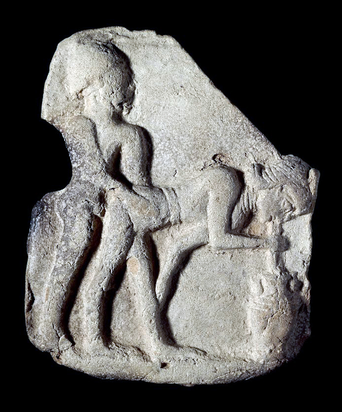
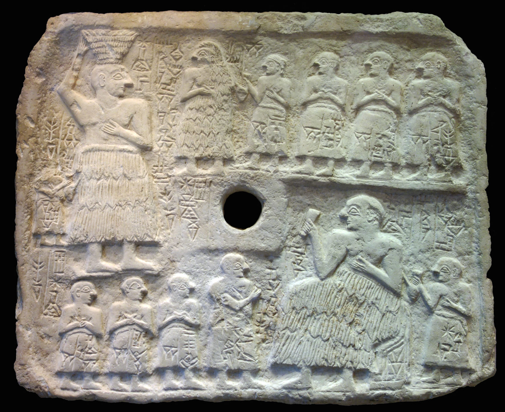
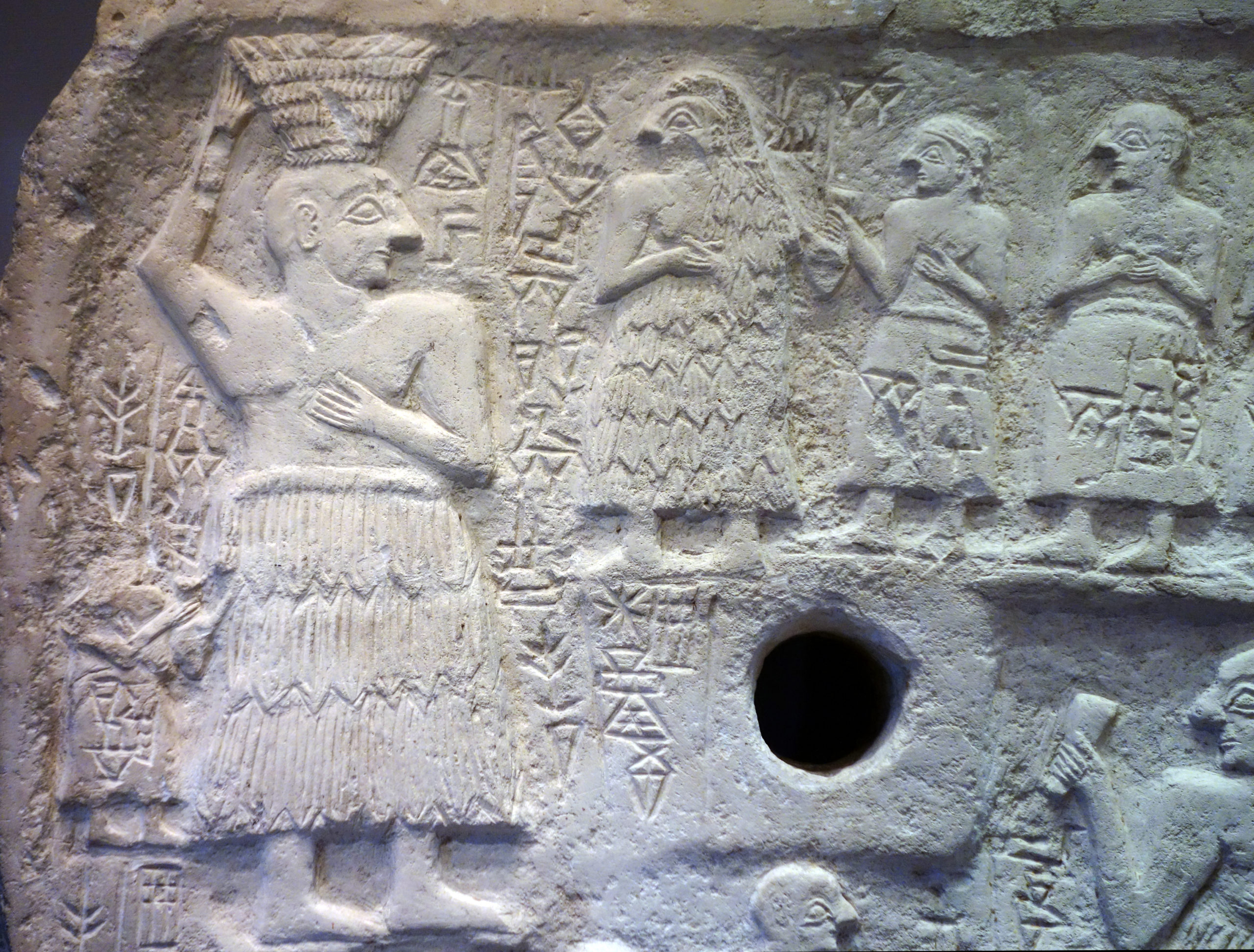
Perforated relief of Ur-Nanshe, king of Lagash, limestone, Early Third Dynasty (2550–2500 B.C.E.), found in Telloh or Tello (ancient city of Girsu). 15-¼ x 18-¼ inches / 39 x 46.5 cm (Musée du Louvre) (photo: Steven Zucker, CC BY-NC-SA
More than 4,000 years ago, Ur-Nanshe, the chief priest and king, displayed his piety and power by building a temple. Archaeologists believe that the years 2800–2350 B.C.E. in Mesopotamia saw both increased population and a drier climate. This would have increased competition between city-states which would have vied for arable land. As conflicts increased, the military leadership of temple administrators became more important. Art of this period emphasizes a new combination of piety and raw power in the representation of its leaders. In fact, the representation of human figures becomes more common and more detailed in this era.
This votive plaque, which would have been hung on the wall of a shrine through its central hole, illustrates the chief priest and king of the city-state of Lagash, Ur-Nanshe, helping to build and then commemorate the opening of a temple of Ningirsu, the patron god of his city. The plaque was excavated at Girsu. There is some evidence that Girsu was then the capital of the city-state of Lagash.
Detail, Perforated relief of Ur-Nanshe, king of Lagash, limestone, Early Third Dynasty (2550–2500 B.C.E.), found in Telloh or Tello (ancient city of Girsu), 39 x 46.5 cm (Musée du Louvre; photo: Steven Zucker, CC BY-NC-SA 2.0)
The top portion of the plaque depicts Ur-Nanshe helping to bring mud bricks to the building site accompanied by his wife and sons. The bottom shows Ur-Nanshe seated at a banquet, enjoying a drink, again accompanied by his sons. In both, he wears the traditional tufted woolen skirt called the kaunakes and shows off his broad muscular chest and arms.
The following video is an excellent description of the role and composition of free-standing figures that were associated with temples and shrines. Pay particular attention to the role (function played by these depictions of humans (not gods or rulers) who which to offer unceasing prayers to the gods. This type of figure is known as a votive figure. Zucker and Harris also analyze the form of the figure, focusing on standard characteristics seen in many of these works – the emphasis on frontality and symmetry.
Standing Male Worshipper (Tell Asmar)
by DR. SENTA GERMAN
One of a group buried in a temple almost 5,000 years ago, this statue’s job was to worship Abu—forever.
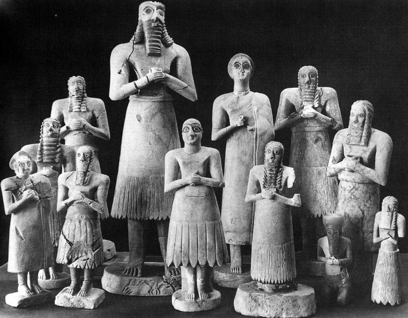
Twelve votive figures, from the Square Temple at Eshnunna (modern Tell Asmar, Iraq), c. 2900–2350 B.C.E. (Early Dynastic period)
Twelve statues from the “Square Temple” at Eshnunna (modern Tell Asmar, Iraq)
Ancient Iraq (select cities), second half of the 3rd millennium B.C.E.
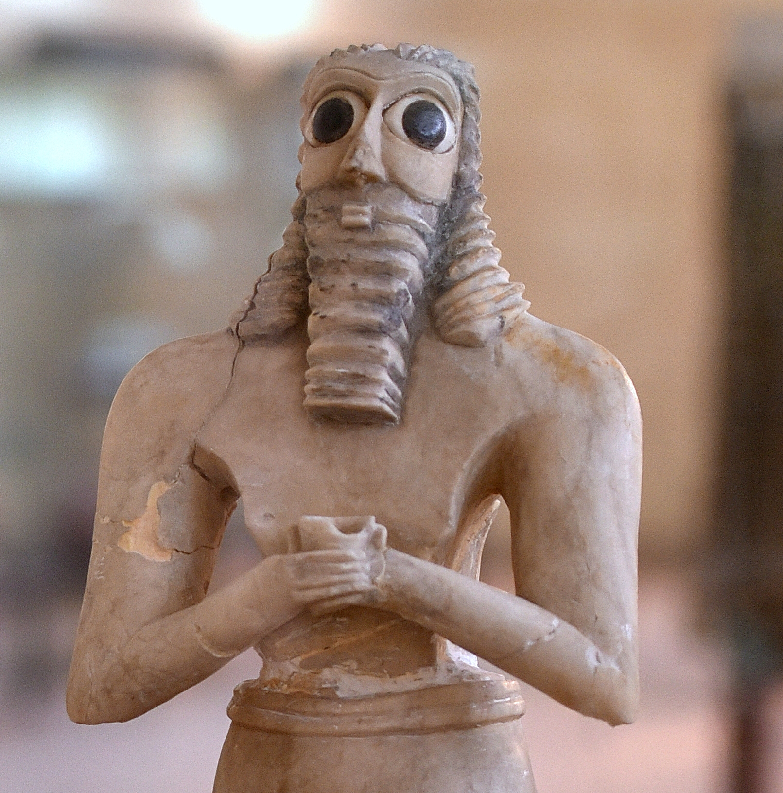
The group of twelve statues from Tell Asmar are among the most important examples of early sculpture from the Ancient Near East.
The figures date to the Early Dynastic period of ancient Mesopotamia (2900–2350 B.C.E.) and were discovered during excavations in Iraq in 1934. These figures were found below the floor of a temple known as the “Square Temple” (likely dedicated to the God Abu). They range in size (from 9 to 28 inches; 23 to 72 cm) and in condition (some still displaying painting and inlay; others broken). All of them, however, appear deeply focused, staring straightforward, some with very large eyes, most with hands clasped, some holding cups. The figures were excavated by the Oriental Institute of the University of Chicago but are now dispersed in the collections of The Metropolitan Museum, New York, the National Museum of Iraq, and the Oriental Institute, Chicago.
The figures and their archaeological context
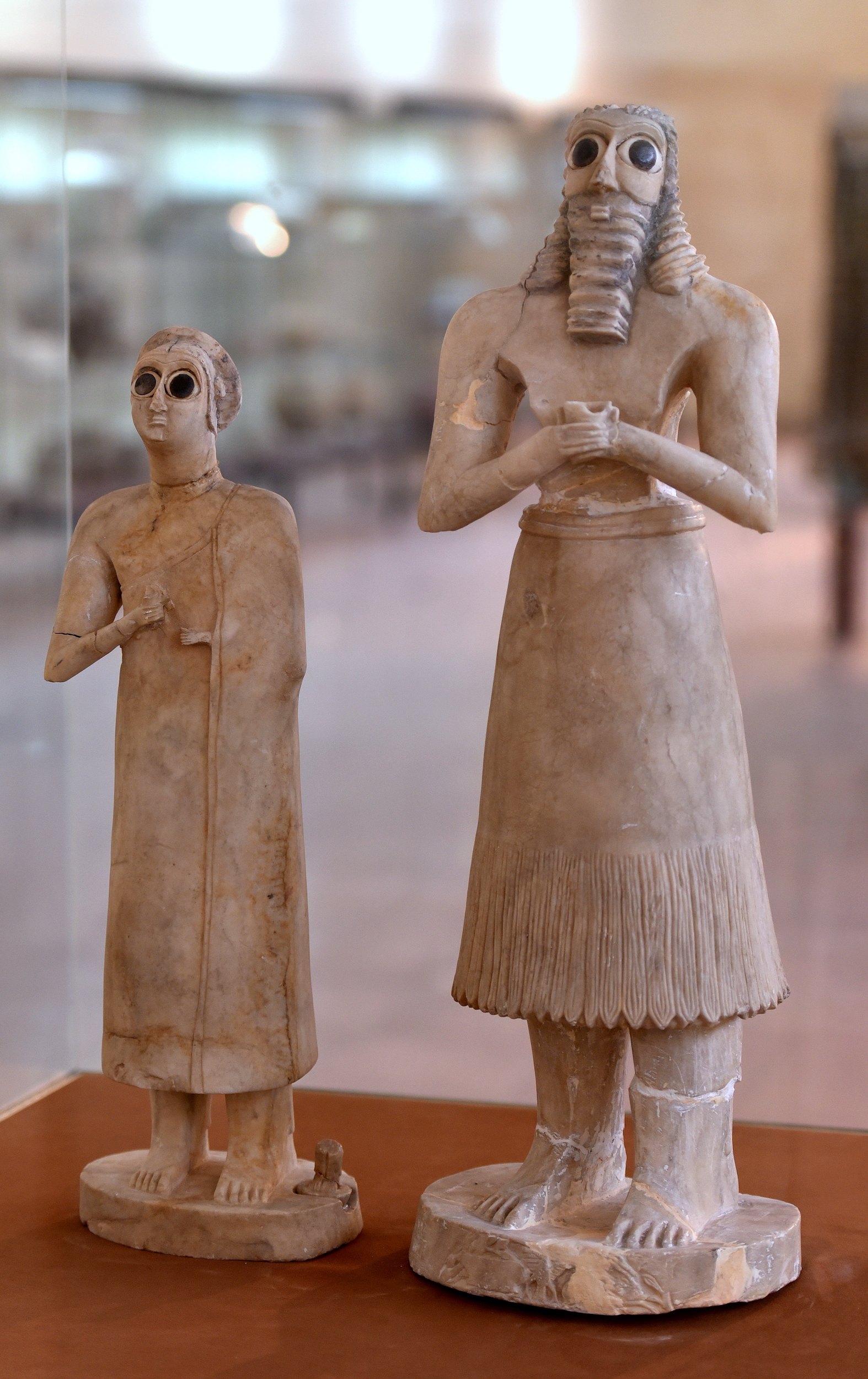
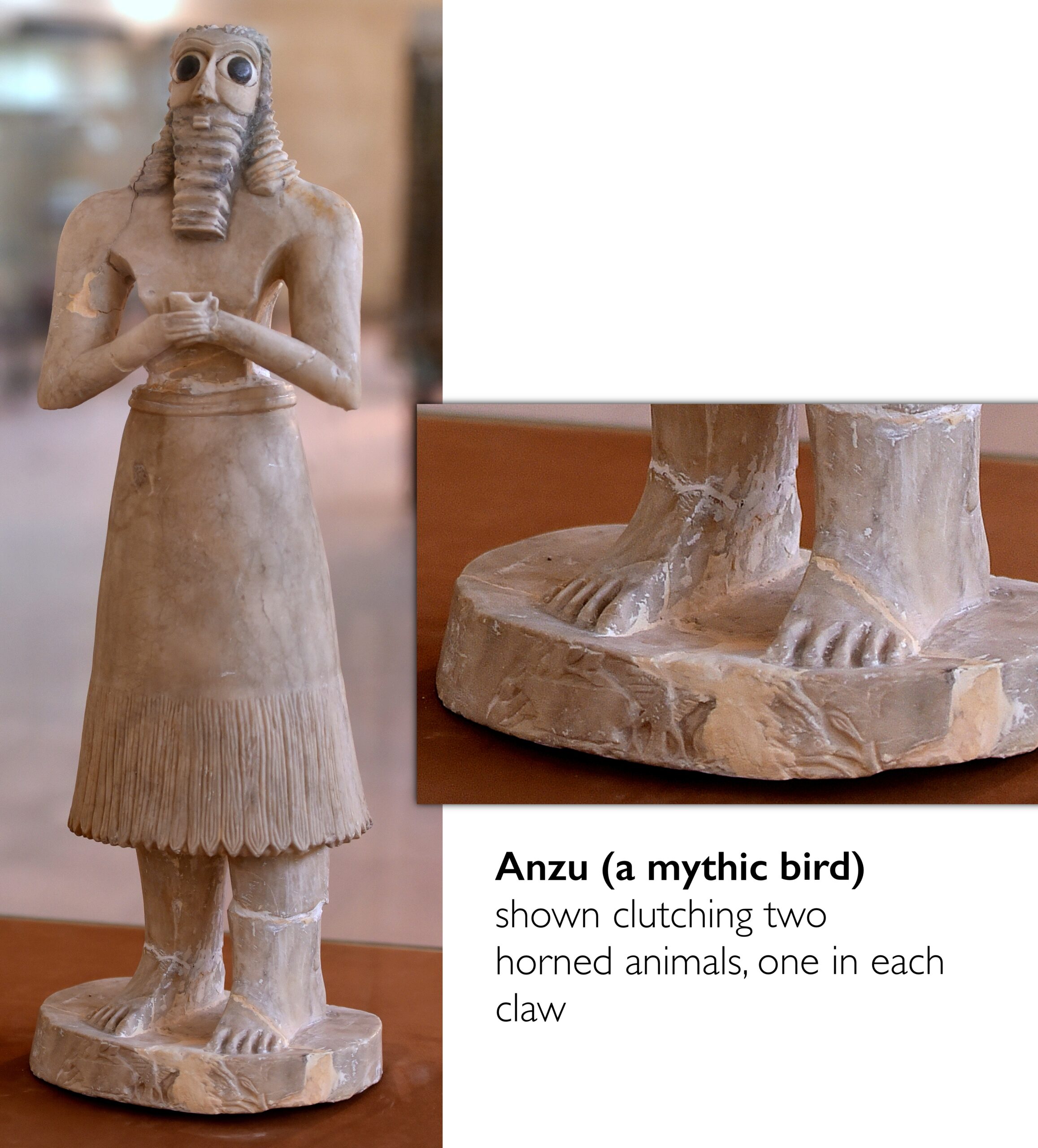
Of the twelve statues found, ten are male and two are female; eight of the figures are made from gypsum, two from limestone, and one (the smallest) from alabaster; all would have been painted. They appear to all be performing the same act and what we know about their archaeological context can help us understand what that might be. One statue in particular stands out from the rest: the tallest man with long dark flowing locks.
Female and male votive figures (on the right is the tallest figure of the group of twelve), from the Square Temple at Eshnunna (modern Tell Asmar, Iraq), c. 2900–2350 B.C.E. (Early Dynastic period) (The Iraq Museum, Baghdad; photo: Dr. Osama Shukir Muhammed Amin, CC BY-SA 4.0)
Not gods, but adorants
From the Early Dynastic period sculptures such as these were common in temples. They are generally understood by art historians and archaeologists to be an image of the god to whom the temple was dedicated. They would be placed on raised platforms and were the recipients of gifts, as a proxy for the god.
However, the collection of statues from Tell Asmar appear to be of a different type, not images of gods and goddesses but rather adorants, mortals who stand in perpetual worship of the god of the temple. We know this because some of the statues are inscribed on the back or bottom with a personal name and prayer; others state “one who offers prayers.” Therefore, these sculptures represent a very early form of individual actions of faith, expressions of personal agency. Some of the sculptures are holding small cups which look a lot like a common cup of the era known as the solid-footed goblet. Hundreds of cups of this type were found deposited in a space near to the sanctuary where the sculptures were found, likely used to pour libations.
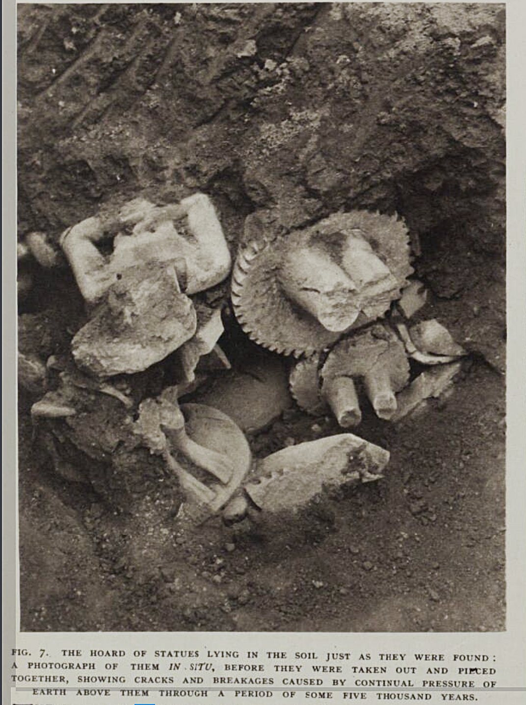
Caption: The Hoard of Statues Lying in the Soil Just as They Were Found, “An Extraordinary Discovery of Early Sumerian Sculpture,” Illustrated London News (May 19, 1934), p. 774.
Who were these early pious actors? The statues were discovered together, packed one on top of another in several layers within a 33 x 20 inch (85 x 50 cm) pit and just by the altar of the temple. Because of the circumstances of this find they are assumed to be a group of alike sculptures, although of a special kind, for sure. Given the high status material from which they are made, the inclusion of writing as well as their privileged space within the temple, we might assume these represent elite people, both men and women, interestingly.
Although their style is abstract and there is no sense of portraiture among them, they are all unique in small ways, either in the rendering of hair, facial expression or even feet; the material of the inlays is also variable, some of white shell or black limestone and even one of lapis lazuli. These sculptures might also represent a clue about how society was changing in the Early Dynastic period. Archaeologists believe that this group of sculptures representing mortals from Tell Asmar were not only working spiritually on behalf of each individual but also as a group, asserting a new status of elite non-religious classes within the context of the temple.
Feet and base (detail), Votive figure from the Square Temple at Eshnunna (modern Tell Asmar, Iraq), c. 2900–2350 B.C.E. (Early Dynastic period) (The Iraq Museum, Baghdad; photo: Dr. Osama Shukir Muhammed Amin, CC BY-SA 4.0)
One figure who stands out
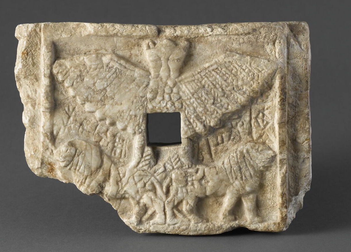
As mentioned above, one figure stands out from the group. He is the tallest with curly locks flowing down over his wide shoulders, his face slightly upturned, making him seem somewhat less obsequious than the rest. On the base of this sculpture there is a rough image carved as well, which also differentiates it from the others. This image shows an Anzu bird clutching two horned animals, one in each claw. This configuration—of Anzu clutching animals—is associated with the thunder god Ninurta (also known as Ningirsu), and also associated with the god of vegetation Abu.
Bird-god Anzu on the Votive relief of Ur-Nanshe, king of Lagash, perforated relief, c. 2495–2465 B.C.E. (Ancient Girsu), alabaster, 15.1 x 21.6 cm (Musée du Louvre, Paris)
Votive figure from the Square Temple at Eshnunna (modern Tell Asmar, Iraq), c. 2900–2350 B.C.E. (Early Dynastic period) (The Iraq Museum, Baghdad; photo: Dr. Osama Shukir Muhammed Amin, CC BY-SA 4.0)
This figure’s luxurious hair, more engaging face and godly image on the base has led to his identification of a very old character type in Ancient Near Eastern art and literature, the long-haired hero who is sometimes nude and sometimes belted.
If this identification is true, we might wonder if the person who dedicated this statue saw himself as a heroic, Gilgamesh-like character (Gilgamesh was a hero in ancient Mesopotamian mythology and the protagonist of the Epic of Gilgamesh, an epic poem written during the late 2nd millennium B.C.E.).
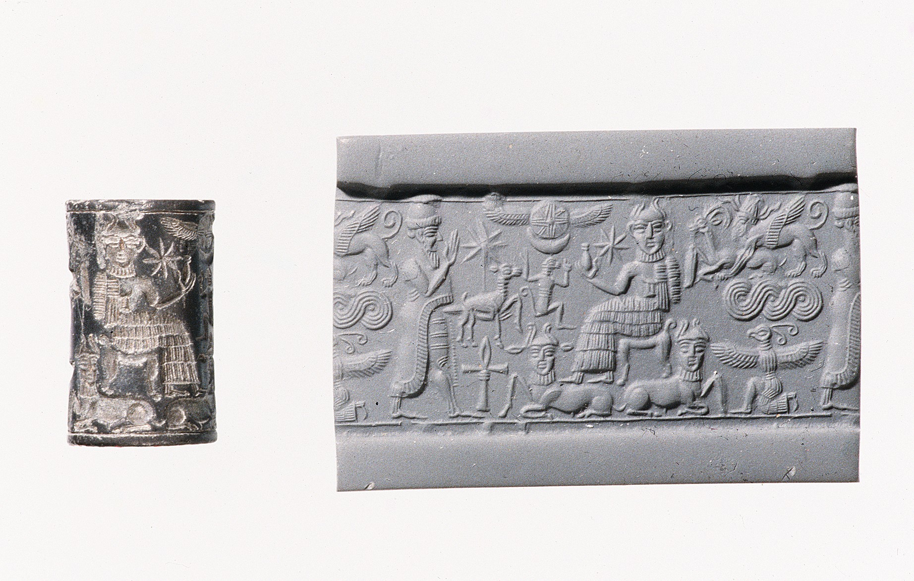
Cylinder Seal (with modern impression), royal worshipper before a god on a throne with bull’s legs; human-headed bulls below, c. 1820–1730 B.C.E., hematite, 2 cm tall (The Metropolitan Museum of Art)
Signed with a cylinder seal
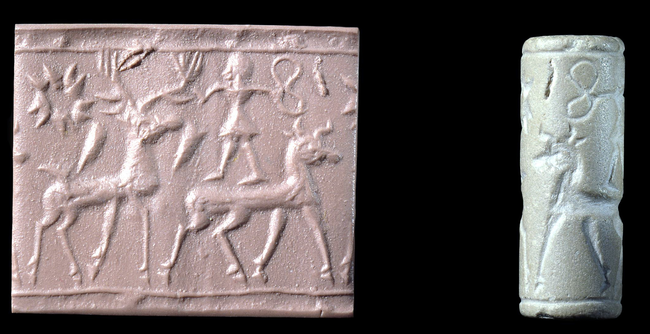
Cuneiform was used for official accounting, governmental and theological pronouncements and a wide range of correspondence. Nearly all of these documents required a formal “signature,” the impression of a cylinder seal.
A cylinder seal is a small pierced object, like a long round bead, carved in reverse (intaglio) and hung on strings of fiber or leather. These often beautiful objects were ubiquitous in the Ancient Near East and remain a unique record of individuals from this era. Each seal was owned by one person and was used and held by them in particularly intimate ways, such as strung on a necklace or bracelet.
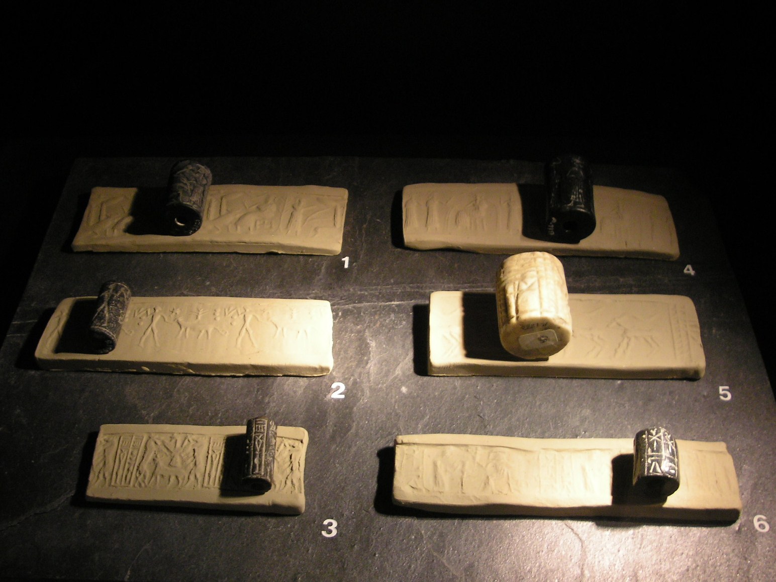
Seals with modern impression strips. (1) Cylinder seal, winged gate of heaven on a bull, tree of life, a servant holds the ropes of the gate of heaven, Akkad period, c. 2200 B.C.E.; (2) Cylinder seal, Gilgamesh searching for the tree of immortality, which is guarded by a dragon. The holes are dens of dangerous animals, Assyrian, c. 2000 B.C.E.; (3) Cylinder seal, Babylonian copy of ancient Sumerian motifs and (misunderstood) ancient Sumerian characters, Babylon, mid-1st millennium B.C.E., steatite (private collection); (4) Cylinder seal, worship before the god “Ea”, fertilizing water, Babylon, Akkad period, c. 2300 B.C.E., steatite; (5) Cylinder seal, the Holy Flock in front of the Temple, Babylon, Djemdet Nasr period, c. 2800 B.C.E., limestone; and (6) Cylinder seal, Babylon, c. 3000 B.C.E, black steatite (Collection Basler Papiermuehle, Basel; photo: Gryffindor)
When a signature was required, the seal was taken out and rolled on the pliable clay document, leaving behind the positive impression of the reverse images carved into it. However, some seals were valued not for the impression they made, but instead, for the magic they were thought to possess or for their beauty.
The first use of cylinder seals in the Ancient Near East dates to earlier than the invention of cuneiform, to the Late Neolithic period (7600–6000 B.C.E.) in Syria. However, what is most remarkable about cylinder seals is their scale and the beauty of the semi-precious stones from which they were carved. The images and inscriptions on these stones can be measured in millimeters and feature incredible detail.
The stones from which the cylinder seals were carved include agate, chalcedony, lapis lazuli, steatite, limestone, marble, quartz, serpentine, hematite, and jasper; for the most distinguished there were seals of gold and silver. To study Ancient Near Eastern cylinder seals is to enter a uniquely beautiful, personal and detailed miniature universe of the remote past, but one which was directly connected to a vast array of individual actions, both mundane and momentous.
Cylinder seal, owned by a woman named Šaša, Akkadian, calcite, 39 x 22 mm, from Khafajeh, Iraq (Oriental Institute, University of Chicago)
Why cylinder seals are interesting
Art historians are particularly interested in cylinder seals for at least two reasons. First, it is believed that the images carved on seals accurately reflect the pervading artistic styles of the day and the particular region of their use. In other words, each seal is a small time capsule of what sorts of motifs and styles were popular during the lifetime of the owner. These seals, which survive in great numbers, offer important information to understand the developing artistic styles of the Ancient Near East.
The second reason why art historians are interested in cylinder seals is because of the iconography (the study of the content of a work of art). Each character, gesture and decorative element can be “read” and reflected back on the owner of the seal, revealing his or her social rank and even sometimes the name of the owner. Although the same iconography found on seals can be found on carved stelae, terra cotta plaques, wall reliefs, and paintings, its most complete compendium exists on the thousands of seals which have survived from antiquity.
The Standard of Ur is a fascinating rectangular box-like object which, through intricate mosaic scenes, presents the violence and grandeur of Sumerian kingship. It is made up of two long flat panels of wood (and two short sides) and is covered with bitumen (a naturally occurring petroleum substance, essentially tar) in which small pieces of carved shell, red limestone, and lapis lazuli were set. It is thought to be a military standard, something common in battle for thousands of years: a readily visible object held high on a pole in the midst of the combat and paraded in victory to symbolize the army (or individual divisions of the army) of a war lord or general. Although we don’t know if this object ever saw the melee of battle, it certainly witnessed a grisly scene when it was deposited in one of the royal graves at the site of Ur in the mid-3rd millennium B.C.E.
In the 1920s the British archaeologist Sir Leonard Woolley worked extensively at Ur and in 1926 he uncovered a huge cemetery of nearly 2,000 burials spread over an area of 70 x 55 m (230 x 180 ft). Most graves were modest, however a group of sixteen were identified by Woolley as royal tombs because of their wealthier grave goods and treatment at interment.
Sir Leonard Woolley, Ur Excavations, volume II, The Royal Cemetery, Plates (British Museum, London and The University Museum, Philadelphia, 1934), plate 8 (available via the Internet Archive)
Each of these tombs contained a chamber of limestone rubble with a vaulted roof of mud bricks. The main burial of the tomb was placed in this chamber and surrounded by treasure (offerings of copper, gold, silver and jewelry of lapis lazuli, carnelian, agate, and shell). The main burial was also accompanied by several other bodies in the tomb, a mass grave outside the chamber, often called the Death Pit. We assume that all these individuals were sacrificed at the time of the main burial in a horrific scene of deference.
One of the royal graves (PG779) had four chambers but no death pit. It had been plundered in antiquity but one room was largely untouched and had the remains of at least four individuals. In the corner of this room the remains of the Standard of Ur were found. One of its long sides was found lying face down in the soil with the other one face up, which lead Woolley to conclude that it was a hollow structure; additional inlay were found on either side of the short ends and appeared to fill a triangular shape and which lead to the Standard being reconstructed with its sloping sides. The remains of the Standard were found above the right shoulder of a man whom Woolley thought had carried it attached to a pole. The identification of this object as a military standard is by no means secure; the hollow shape could just as easily have been the sound box of a stringed instrument, such as the Queen’s Lyre found in an adjacent tomb.
War and peace
The two sides of the Standard appear to be the two poles of Sumerian kingship, war and peace. The war side was found face up and is divided into three registers (bands), read from the bottom up, left to right. The story begins at the bottom with war carts, each with a spearman and driver, drawn by donkeys trampling fallen enemies, distinguished by their nudity and wounds, which drip with blood. The middle band shows a group of soldiers wearing fur cloaks and carrying spears walking to the right while bound, naked enemies are executed and paraded to the top band where more are killed.
In the center of the top register, we find the king, holding a long spear, physically larger than everyone else, so much so, his head breaks the frame of the scene. Behind him are attendants carrying spears and battle axes and his royal war cart ready for him to jump in. There is a sense of a triumphal moment on the battlefield, when the enemy is vanquished and the victorious king is relishing his win. There is no reason to believe that this is a particular battle or king as there is nothing which identifies it as such; we think it is more of a generic image of a critically important aspect of Ancient Near Eastern kingship.
The opposite peace panel also illustrates a cumulative moment, that of the celebration of the king, this time for great agricultural abundance which is afforded by peace. Again, beginning at the bottom left, we see men carrying produce on their shoulders and in bags and leading donkeys. In the central band, men lead bulls, sheep and goats, and carry fish. In the top register a grand feast is taking place, complete with comfortable seating and musical accompaniment.
On the left, the largest figure, the king, is seated wearing a richly flounce fur skirt, again so large, even seated, he breaks the frame. Was it an epic tale of battle that the singer on the far right is performing for entertainment as he plays a bull’s head lyre, again, like the Queen’s Lyre? We will never know but certainly such powerful images of Sumerian kingship tell us that whomever ended his life with the Standard of Ur on his shoulder was willing to give his life in a ritual of kingly burial.
Source: Dr. Senta German, “Standard of Ur and other objects from the Royal Graves,” in Smarthistory, July 26, 2023, accessed August 30, 2024, https://smarthistory.org/standard-of-ur-2/.
This is one of an almost identical pair discovered by Leonard Woolley in the ‘Great Death Pit’, one of the graves in the Royal Cemetery at Ur. The other is now in the University of Pennsylvania Museum in Philadelphia. It was named the ‘Ram in a Thicket’ by the excavator Leonard Woolley, who liked biblical allusions. In Genesis 22:13, God ordered Abraham to sacrifice his son Isaac, but at the last moment “Abraham lifted up his eyes, and looked, and behold behind him a ram caught in a thicket by his horns: and Abraham went and took the ram, and offered him up for a burnt offering in the stead of his son.”
The ‘ram’ is more accurately described as a goat, and he reaches up for the tastiest branches in a pose often adopted by goats. Goats and sheep in the Near East were among the earliest animals to be domesticated. They were an everyday feature of agricultural life and are regularly depicted by artists in many different ways.
The figure had been crushed flat by the weight of the soil and the wooden core had perished. Wax was used to keep the pieces together as it was lifted from the ground, and it was then pressed back into shape. The ram’s head and legs are covered in gold leaf, its ears are copper (now green), its twisted horns and the fleece on its shoulders are of lapis lazuli, and its body fleece is made of shell. Its genitals are gold. The tree is covered in gold leaf, with golden flowers, the whole supported on a small rectangular base decorated with a mosaic of shell, red limestone, and lapis lazuli. The tube rising from the goat’s shoulders suggests it was used to support something, most likely a bowl.
Competition between Akkad in the north and Ur in the south created two centralized regional powers at the end of the third millennium.
This centralization was military in nature and the art of this period generally became more martial. The Akkadian Empire was begun by Sargon, a man from a lowly family who rose to power and founded the royal city of Akkad (Akkad has not yet been located, though one theory puts it under modern Baghdad).
During the period of the Akkadian Empire (2271-2154 BCE), sculpture of the human form grew increasingly naturalistic, and its subject matter increasingly about politics and warfare. A cast bronze portrait head believed to be that of King Sargon combines a naturalistic nose and mouth with stylized eyes, eyebrows, hair, and beard. Although the stylized features dominate the sculpture, the level of naturalism was unprecedented.
Head of an Akkadian ruler
This sculpture of an unidentified Akkadian ruler (some say it is Sargon, but no one knows) is one of the most beautiful and terrifying images in all of ancient Near Eastern art. The life-sized bronze head shows in sharp geometric clarity, locks of hair, curled lips, and a wrinkled brow. Perhaps more awesome than the powerful and somber face of this ruler is the violent attack that mutilated it in antiquity.
Head of an Akkadian ruler, 2250–2200 B.C.E., bronze (photo: M.E.L. Mallowan)
The Victory Stele of Naram Sin provides an example of the increasingly violent subject matter in Akkadian art, a result of the violent and oppressive climate of the empire. Here, the king is depicted as a divine figure, as signified by his horned helmet. In typical hieratic fashion, Naram Sin appears larger than his soldiers and his enemies. The king stands among dead or dying enemy soldiers as his own troops look on from a lower vantage point. The figures are depicted in high relief to amplify the dramatic significance of the scene. On the right-hand side of the stele, the cuneiform script provides a narration.
by DR. BETH HARRIS and DR. STEVEN ZUCKER
Naram-Sin leads his victorious army up a mountain, as vanquished Lullubi people fall before him.
Victory Stele of Naram-Sin, 2254-2218 B.C.E., pink limestone, Akkadian (Musée du Louvre, Paris)
This monument depicts the Akkadian victory over the Lullubi Mountain people. In the 12th century B.C.E., a thousand years after it was originally made, the Elamite king, Shutruk-Nahhunte, attacked Babylon and, according to his later inscription, the stele was taken to Susa in what is now Iran. A stele is a vertical stone monument or marker often inscribed with text or relief carving.
Cylinder seal and modern impression: nude bearded hero wrestling with a water buffalo; bull-man wrestling with lion, c. 2250–2150 B.C.E., Akkadian, Serpentine, 1.42″ / 3.61 cm (The Metropolitan Museum of Art). Video from The Metropolitan Museum of Art.
The kingdom of Akkad ends with internal strife and invasion by the Gutians from the Zagros mountains to the northeast. The Gutians were ousted in turn and the city of Ur, south of Uruk, became dominant. King Ur-Nammu established the third dynasty of Ur, also referred to as the Ur III period.
diorite – a dense, hard to carve material, imported and considered valuable; reserved for royal use.
Following the collapse of Akkadian rule, small city-states emerged, based on the earlier Sumerian city-states, giving rise to the term “Neo-Sumerian”. Ur and other cities experienced a renaissance.
Seated Gudea holding temple plan
by DR. BETH HARRIS and DR. STEVEN ZUCKER
Shown with an architectural plan in his lap, this prince constructed temples to the gods and likenesses of himself.
Source: Dr. Beth Harris and Dr. Steven Zucker, “Seated Gudea holding temple plan,” in Smarthistory, October 26, 2017, accessed August 30, 2024, https://smarthistory.org/gudea/.
Ziggurat of Ur
by DR. SENTA GERMAN
The Great Ziggurat of Ur has been reconstructed twice, in antiquity and in the 1980s—what’s left of the original?
Ziggurat of Ur (largely reconstructed), c. 2100 B.C.E., mud brick and baked brick, Tell el-Mukayyar, Iraq (photo: Tla2006)
The Great Ziggurat
The ziggurat is the most distinctive architectural invention of the Ancient Near East. Like an ancient Egyptian pyramid, an ancient Near Eastern ziggurat has four sides and rises up to the realm of the gods. However, unlike Egyptian pyramids, the exterior of ziggurats were not smooth but tiered to accommodate the work which took place at the structure, as well as the administrative oversight and religious rituals essential to Ancient Near Eastern cities. Ziggurats are found scattered around what is today Iraq and Iran, and stand as an imposing testament to the power and skill of the ancient culture that produced them.
One of the largest and best-preserved ziggurats of Mesopotamia is the Great Ziggurat at Ur. Small excavations occurred at the site around the turn of the twentieth century, and in the 1920s Sir Leonard Woolley, in a joint project with the University of Pennsylvania Museum in Philadelphia and the British Museum in London, revealed the monument in its entirety.
Leonard Woolley, photo with excavation workers, c. 1923–24, featuring the ziggurat of Ur, c. 2100 B.C.E., Tell el-Mukayyar, Iraq (photo: Penn Museum, Philadelphia)
What Woolley found was a massive rectangular pyramidal structure, oriented to true north, 210 x 150 feet (64 x 46 meters), constructed with three levels of terraces, standing originally between 70 x 100 feet (21 x 30 meters) high. Three monumental staircases led up to a gate at the first terrace level. Next, a single staircase rose to a second terrace which supported a platform on which a temple and the final and highest terrace stood. The core of the ziggurat is made of mud brick covered with baked bricks laid with bitumen, a naturally occurring tar. Each of the baked bricks measured about 11.5 x 11.5 x 2.75 inches (29 x 29 x 7 cm) and weighed as much as 33 pounds. The lower portion of the ziggurat, which supported the first terrace, would have used some 720,000 baked bricks. The resources needed to build the ziggurat at Ur are staggering.
Ziggurat of Ur (largely reconstructed), c. 2100 B.C.E., mud brick and baked brick, Tell el-Mukayyar, Iraq (photo: Kaufingdude, CC BY-SA 3.0)
Moon Goddess Nanna
The ziggurat at Ur and the temple on its top were built around 2100 B.C.E. by the king Ur-Nammu of the Third Dynasty of Ur for the moon goddess Nanna, the divine patron of the city state. The structure would have been the highest point in the city by far and, like the spire of a medieval cathedral, would have been visible for miles around, a focal point for travelers and the pious alike. As the ziggurat supported the temple of the patron god of the city of Ur, it is likely that it was the place where the citizens of Ur would bring agricultural surplus and where they would go to receive their regular food allotments. In antiquity, to visit the ziggurat at Ur was to seek both spiritual and physical nourishment.
Ziggurat at Ali Air Base Iraq, 2005, featuring ziggurat of Ur, partly restored, c. 2100 B.C.E. mudbrick and baked brick, Tell el-Mukayyar, Iraq
Clearly the most important part of the ziggurat at Ur was the Nanna temple at its top, but this, unfortunately, has not survived. Some blue glazed bricks have been found which archaeologists suspect might have been part of the temple decoration. The lower parts of the ziggurat, which do survive, include amazing details of engineering and design. For instance, because the unbaked mud brick core of the temple would, according to the season, be alternatively more or less damp, the architects included holes through the baked exterior layer of the temple allowing water to evaporate from its core. Additionally, drains were built into the ziggurat’s terraces to carry away the winter rains.
U.S. soldiers descend the ziggurat of Ur, 2009, Tell el-Mukayyar, Iraq (photo: United States Forces Iraq, CC BY-NC-ND 2.0)
Hussein’s assumption
The ziggurat at Ur has been restored twice. The first restoration was in antiquity. The last Neo-Babylonian king, Nabodinus, apparently replaced the two upper terraces of the structure in the 6th century B.C.E. Some 2,400 years later in the 1980s, Saddam Hussein restored the façade of the massive lower foundation of the ziggurat, including the three monumental staircases leading up to the gate at the first terrace. Since this most recent restoration, however, the ziggurat at Ur has experienced some damage. During the recent war led by American and coalition forces, Saddam Hussein parked his MiG fighter jets next to the ziggurat, believing that the bombers would spare them for fear of destroying the ancient site. Hussein’s assumptions proved only partially true as the ziggurat sustained some damage from American and coalition bombardment.
Between 1400 and 1200 B.C.E. the Hittites established one of the great empires of the ancient Middle East. At its height, the empire encompassed central Turkey, north western Syria, and Upper Mesopotamia (north eastern Syria and northern Iraq).
Although they spoke an Indo-European language, the Hittites adopted many of the traditions of Mesopotamia, including the cuneiform writing system. At the capital, Hattusa, Archaeologists have excavated royal archives written in cuneiform on clay tablets.The Hittites were famous for their skill in building and using chariots. They also pioneered the manufacture and use of iron.
By 1300 the Hittite Empire bordered on Egypt and both powers vied for control of wealthy cities on the Mediterranean coast. This led to the Battle of Kadesh with Rameses II (1274 B.C.E.) On Rameses II’s monuments, the battle was commemorated as a great victory for Egypt, but the Hittite account, found at Hattusas, suggests that the battle was closer fought.
Civil war and rivaling claims to the throne, combined with external threats weakened the Hittites and by 1160 B.C.E., the Empire had collapsed. Hittite culture survived in parts of Syria such as Carchemish which had once been under their power. These Neo-Hittites wrote Luwian, a language related to Hittite, using a hieroglyphic script. Many modern city names in Turkey are derived from their Hittite name, for example Sinop or Adana, showing the impact of Hittite culture in Anatolia.
This limestone cylinder seal was found by the excavator Leonard Woolley when he was clearing a cave under the north wall at Carchemish. The town was defended at this point by a double wall with the space between divided by cross-walls. The walls rested on top of a cliff and the cave was below the outer wall—n fact the wall had collapsed at this point because of the collapse of the cave roof near the mouth.
Behind the inner town wall three vertical shafts cut in the rock gave access to the cave. Wall foundations showed that these had once been enclosed in a building. The cave may have served as an emergency exit only for use in times of war, and in peace time it may have been kept blocked: there was evidence that at one stage the entrance to the cave had been blocked by a wall. Inside, the cave had been artificially shaped so that the roof, floor and walls were flat.
The cave was in use until late Roman times. This cylinder seal was found high up in the filling within it, and can be dated to the Hittite period.
This limestone cylinder seal depicts a stag and a bull, two wedges, a sun with rays, and, above the bull, a kilted figure holding a figure-of-eight shield and grasping one of the stag’s antlers. The stag may symbolize a Hittite hunting god and the bull may stand for the weather god of Hatti.
A tiny gold figure
This tiny gold figure wears the very distinctive Hittite version of the horned headdress, the usual way of depicting deities in Mesopotamia. The curved weapon he carries could be a sword, or perhaps a hunting weapon identifying him as a god of hunting.
Thousands of tablets from the Hittite capital of Hattusa (modern Bogazköy in central Turkey) reveal that the state religion was based on the worship of natural phenomena such as weather, sun, mountains and water. These were all depicted in human form, distinguished by their horned headwear. The Hittite king played a central role in religious rituals. These included his being bathed to wash away collective sin.
The Hittites adopted many of the deities of the surrounding regions, including those of the Hurrians. As the empire expanded into Syria during the 14th century B.C.E., so did the pantheon. The Hittites themselves spoke of a thousand gods, and Mesopotamian and Syrian gods were either equated with their own deities or simply added to the list. Among the most important male gods was Teshub, the Hurrian storm god, whose animal symbol was the bull. He was the husband of the goddess Hepat, and they were equated with the weather-god of Hatti and his consort, the sun-goddess of Arina.
Most of the thirty-eight small gold figures (five illustrated here) are inlaid with steatite or lapis lazuli (a rare blue stone imported from Afghanistan). They represent Hittite deities and are very similar to the gods carved in the thirteenth century BC on the rock of the open-air shrine at Yazilikaya near the Hittite capital of Hattusa (modern Bogazköy) in central Anatolia. Since this is their probable date, they must have decorated an object that became an heirloom, as they were found in a grave of the seventh century BC.
The rich burial, which also contained a cylinder of lapis lazuli, an openwork gold strip and disc and gold tassels from the ends of a belt, was discovered by Leonard Woolley when he was excavating the Neo-Hittite and later levels at Carchemish. The burial was a cremation within the walls of the city. This was unusual because at that time cremation burials were generally made in cemeteries outside the walls of settlements. The cremated bones were in a coarse domestic vessel instead of the normal urn, and, because the burial was very rich, Woolley suggested that it might have been that of an important person who died during the siege of Carchemish by Nebuchadnezzar of Babylon in 605 B.C.E..
The Assyrian empire dominated Mesopotamia and all of the Near East for the first half of the first millennium B.C.E., led by a series of highly ambitious and aggressive warrior kings. Assyrian society was entirely military, with men obliged to fight in the army at any time. State offices were also under the purview of the military.
Ashurbanipal slitting the throat of a lion from his chariot (detail), Ashurbanipal Hunting Lions, gypsum hall relief from the North Palace, Nineveh, c. 645–635 B.C.E., excavated by H. Rassam beginning in 1853 (British Museum; photo: Steven Zucker, CC BY-NC-SA 2.0)
Indeed, the culture of the Assyrians was brutal, the army seldom marching on the battlefield but rather terrorizing opponents into submission who, once conquered, were tortured, raped, beheaded, and flayed with their corpses publicly displayed. The Assyrians torched enemies’ houses, salted their fields, and cut down their orchards.
Luxurious palaces
As a result of these fierce and successful military campaigns, the Assyrians acquired massive resources from all over the Near East which made the Assyrian kings very rich. The palaces were on an entirely new scale of size and glamour; one contemporary text describes the inauguration of the palace of Kalhu, built by Ashurnasirpal II, to which almost 70,000 people were invited to banquet.
Lion pierced with arrows (detail), Lion Hunts of Ashurbanipal (ruled 669–630 B.C.E.), c. 645 B.C.E., gypsum, Neo-Assyrian, hall reliefs from Palace at Nineveh across the Tigris from present day Mosul, Iraq (British Museum; photo: Steven Zucker, CC BY-NC-SA 2.0)
Some of this wealth was spent on the construction of several gigantic and luxurious palaces spread throughout the region. The interior public reception rooms of Assyrian palaces were lined with large scale carved limestone reliefs which offer beautiful and terrifying images of the power and wealth of the Assyrian kings and some of the most beautiful and captivating images in all of ancient Near Eastern art.
Silent video reconstructs the Northwest Palace of Ashurnasirpal II at Nimrud. Video from The Metropolitan Museum of Art
This silent video reconstructs the Northwest Palace of Ashurnasirpal II at Nimrud (near modern Mosul in northern Iraq) as it would have appeared during his reign in the ninth century B.C.E. The video moves from the outer courtyards of the palace into the throne room and beyond into more private spaces, perhaps used for rituals. (According to news sources, this important archaeological site was destroyed with bulldozers in March 2015 by the militants who occupy large portions of Syria and Iraq.)
Lion Hunts of Ashurbanipal (ruled 669–630 B.C.E.), c. 645 B.C.E., gypsum, Neo-Assyrian, hall reliefs from Palace at Ninevah across the Tigris from present day Mosul, Iraq (British Museum)
Feats of bravery
Like all Assyrian kings, Ashurbanipal decorated the public walls of his palace with images of himself performing great feats of bravery, strength, and skill. Among these he included a lion hunt in which we see him coolly taking aim at a lion in front of his charging chariot, while his assistants fend off another lion attacking at the rear.
Sacking of Susa by Ashurbanipal, North Palace, Nineveh, 647 B.C.E. (British Museum; photo: Carole Raddato, CC BY-SA 2.0)
The destruction of Susa
One of the accomplishments Ashurbanipal was most proud of was the total destruction of the city of Susa. In one relief, we see Ashurbanipal’s troops destroying the walls of Susa with picks and hammers while fire rages within the walls of the city.
The sieging of a city, Wall relief from Nimrud, likely in Mesopotamia, c. 728 B.C.E. (British Museum; photo: Ealdgyth)
Military victories & exploits
In the Central Palace at Nimrud, the Neo-Assyrian king Tiglath-pileser III (ruled from 745 to 727 B.C.E.) illustrates his military victories and exploits, including the siege of a city in great detail. In one scene we see a soldier holding a large screen to protect two archers who are taking aim. The topography includes three different trees and a roaring river, most likely setting the scene in and around the Tigris or Euphrates rivers.
Leveraging their enormous wealth, the Assyrians built great temples and palaces full of art, all paid for by conquest. Although Assyrian civilization, centred in the fertile Tigris valley of northern Iraq, can be traced back to at least the third millennium B.C.E., some of its most spectacular remains date to the first millennium B.C.E. when Assyria dominated the Middle East.
Ashurnasirpal II
The Assyrian king Ashurnasirpal II established Nimrud as his capital. Many of the principal rooms and courtyards of his palace were decorated with gypsum slabs carved in relief with images of the king as high priest and as victorious hunter and warrior. Many of these are displayed in the British Museum.
Ashurnasirpal II, whose name (Ashur-nasir-apli) means, “the god Ashur is the protector of the heir,” came to the Assyrian throne in 883 B.C.E. He was one of a line of energetic kings whose campaigns brought Assyria great wealth and established it as one of the Near East’s major powers.
Ashurnasirpal mounted at least fourteen military campaigns, many of which were to the north and east of Assyria. Local rulers sent the king rich presents and resources flowed into the country. This wealth was used to undertake impressive building campaigns in a new capital city created at Kalhu (modern Nimrud). Here, a citadel mound was constructed and crowned with temples and the so-called North-West Palace. Military successes led to further campaigns, this time to the west, and close links were established with states in the northern Levant. Fortresses were established on the rivers Tigris and Euphrates and staffed with garrisons.
By the time Ashurnasirpal died in 859 B.C.E., Assyria had recovered much of the territory that it had lost around 1100 B.C.E. as a result of the economic and political problems at the end of the Middle Assyrian period.
Later kings continued to embellish Nimrud, including Ashurnasirpal II’s son, Shalmaneser III who erected the Black Obelisk depicting the presentation of tribute from Israel.
During the eighth and seventh centuries B.C.E. Assyrian kings conquered the region from the Persian Gulf to the borders of Egypt. The most ambitious building of this period was the palace of king Sennacherib at Nineveh. The reliefs from Nineveh in the British Museum include a depiction of the siege and capture of Lachish in Judah.
The finest carvings, however, are the famous lion hunt reliefs from the North Palace at Nineveh belonging to Ashurbanipal. The scenes were originally picked out with paint, which occasionally survives, and work like modern comic books, starting the story at one end and following it along the walls to the conclusion.
The Assyrians used a form of gypsum for the reliefs and carved it using iron and copper tools. The stone is easily eroded when exposed to wind and rain and when it was used outside, the reliefs are presumed to have been protected by varnish or paint. It is possible that this form of decoration was adopted by Assyrian kings following their campaigns to the west, where stone reliefs were used in Neo-Hittite cities like Carchemish. The Assyrian reliefs were part of a wider decorative scheme which also included wall paintings and glazed bricks.
The reliefs were first used extensively by king Ashurnasirpal II at Kalhu (Nimrud). This tradition was maintained in the royal buildings in the later capital cities of Khorsabad and Nineveh.
Winged, human-headed bulls served as guardians of the city and its palace—walking by, they almost seem to move.
Lamassu (winged human-headed bulls possibly lamassu or shedu) from the citadel of Sargon II, Dur Sharrukin (now Khorsabad, Iraq), Neo-Assyrian, c. 720–705 B.C.E., gypseous alabaster, 4.20 x 4.36 x 0.97 m, (Musée du Louvre, Paris). These sculptures were excavated by P.-E. Botta in 1843–44. Speakers: Dr. Beth Harris and Dr. Steven Zucker
Human-headed genie watering sacred tree, 883–859 B.C.E., gypseous alabaster with traces of paint, 224.8 x 184.8 cm (Yale Art Gallery, New Haven)
The architecture and sculptural decorations of Neo-Assyrian palaces dating to the first half of the 1st millennium B.C.E. are not only unique in the Ancient Near East but exceptionally powerful and beautiful. Huge courtyards and halls led the visitor deeper and deeper into the king’s realm, revealing more and more complex sculptural programs along the progression. Images depicted the brutal destruction of enemy cities, the ruthless extraction of natural resources, the king hunting lions with a bow and arrow, and sacred spirits (winged men call genii) tending a tree of life.
Between these courtyards and halls, punctuating these scenes of power and prestige are massive pairs of doorway sculptures called Lamassu. The Lamassu are distinctive to Neo-Assyrian architectural sculpture (although the creatures which they represent have a long history in the Ancient Near East, dating to the Early Dynastic period) and several pairs of them survive to this day. The remains of more than 100 Lamassu have been identified at Neo-Assyrian palace sites. Because of their massive size and formidable form, since the discovery of Neo-Assyrian palaces in the 19th century, they have been a source of awe and fascination, even living on in art deco architecture of the 20th century.
A hybrid monster
A lamassu (also called a šedu, aladlammû or genii) is an apotropaic or protective hybrid monster with the bearded head of a mature man, crown of a god, and the winged body of either a bull or lion. They are massive, up to 20 feet tall and weigh as much as 30–50 tons. Remarkably, each is carved from a single slab of limestone, gypsum alabaster, or breccia.
Winged human-headed bull (lamassu or shedu), 721–705 B.C.E. (reign of Sargon II, Neo-Assyrian Period, Khorsabad, ancient Dur Sharrukin, Assyria, Iraq), gypseous alabaster, 4.20 x 4.36 x 0.97 m, excavated by P.-E. Botta 1843–44 (Musée du Louvre, Paris; photo: Steven Zucker, CC BY-NC-SA 2.0)
This pair at the Louvre is from the Palace of Sargon II at Khorsabad and dates from 720–705 B.C.E. and represents a winged bull with the bearded head of a man wearing a double horned crown. The face of the Lamassu is broad, with a strong nose and thick eyebrows which are double arched across his whole forehead. The massive beard is represented as thickly curled and braided, nearly doubling the size of the Lamassu’s face. His wide eyes look straight out over the head of the viewer, as if engaged in matters beyond the human realm. His crown, feather-topped, is decorated with rows of rosettes (a motif associated with divinity and possibly the goddess Ishtar) and set with a double-horned crown, marking the Lamassu as divine. His pointed bovine ears, ringed with gold hoops suspending beads, emerge from beneath the crown as well as long flowing locks which end in rows of tight curls giving a sense of buoyancy. The fur of the bull’s body is also richly curled, although in very organized straight rows which run along its breast, back, side and rear flank. Even the Lamassu’s tail is curled and braided.
Winged human-headed bull (lamassu or shedu), 721–705 B.C.E. (reign of Sargon II, Neo-Assyrian Period, Khorsabad, ancient Dur Sharrukin, Assyria, Iraq), gypseous alabaster, 4.20 x 4.36 x 0.97 m, excavated by P.-E. Botta 1843–44 (Musée du Louvre, Paris; photo: Steven Zucker, CC BY-NC-SA 2.0)
Huge cloven feet
The huge cloven feet of the Lamassu show him both standing and walking, courtesy of the carving having five legs instead of four. This is to present a kind of split view: when one approaches the Lamassu from the front, they look as if they are standing still guarding the door, but when you pass between them, you see all four of their legs walking forward. This odd detail, which is not common to all Lamassu, is done for two reasons. Firstly, because as much of the bulk of the stone must be left intact as possible to help support the weight of arch of the doorway. To carve out the space around the legs of the Lamassu, which would make the fourth front leg visible while passing between them, would weaken the arched doorway. The other reason is to ensure that no matter from what angle one sees the Lamassu, it looks formidable. The legs of the Lamassu are not only massive but very muscular, giving a clear sense of the power of this hybrid creature. Added to this complex sculptural representation, we must recall, was color. Several examples of Neo-Assyrian sculpture have been examined for the remains of their pigment and have been found to still hold microscopic traces of white calcium carbonate and calcium sulfate, bone black and charcoal, hematite red, cinnabar red, and cobalt blue.
Standard inscription in cuneiform (detail), Winged human-headed bull (lamassu or shedu), 721–705 B.C.E. (reign of Sargon II, Neo-Assyrian Period, Khorsabad, ancient Dur Sharrukin, Assyria, Iraq), gypseous alabaster, 4.20 x 4.36 x 0.97 m, excavated by P.-E. Botta 1843–44 (Musée du Louvre, Paris; photo: Steven Zucker, CC BY-NC-SA 2.0)
On two panels between the hind legs of the Lamassu is a long inscription in cuneiform called the standard inscription. This is a statement listing the victories and virtues of King Sargon, his piety and the ways in which the gods have favored him. It also threatens a curse on whomever should seek to harm his palace. This kind of standard inscription is common on many Neo-Assyrian wall reliefs and Lamassu and can be seen as a scriptural representation of the images they are layered upon.
Winged human-headed bull (lamassu or shedu), 721–705 B.C.E. (reign of Sargon II, Neo-Assyrian Period, Khorsabad, ancient Dur Sharrukin, Assyria, Iraq), gypseous alabaster, 4.20 x 4.36 x 0.97 m, excavated by P.-E. Botta 1843–44 (Musée du Louvre, Paris; photo: Steven Zucker, CC BY-NC-SA 2.0)
Awe-inspiring
What is so awe-inspiring about these sculptures is not only their size but the powerful clarity with which they are sculpted and the terrifyingly precise repetition of forms. Curls and horns are incised with deep, powerful cuts in high relief and smoothed into sharp readability. The strict linear, mathematical arrangement of feathers, curls, and rosettes gives the Lamassu a perfected restraint, humanizing the frightening and chaotic hybridity. Possibly the most terrifying and impressive aspect of the carving of the Lamassu, however, is the precision of its sculptural repetition. Dating to an era much before “cut and paste” or any sort of mechanical reproductive methods in sculpture, we find the craftsmen of the Lamassu were masters of scrupulous and endlessly repetitive imitation.
Winged human-headed bull (lamassu or shedu), 721–705 B.C.E. (reign of Sargon II, Neo-Assyrian Period, Khorsabad, ancient Dur Sharrukin, Assyria, Iraq), gypseous alabaster, 4.20 x 4.36 x 0.97 m, excavated by P.-E. Botta 1843–44 (Musée du Louvre, Paris; photo: Steven Zucker, CC BY-NC-SA 2.0)
Backstory
The lamassu in museums today (including the Louvre, shown in our video, as well the British Museum, The Metropolitan Museum of Art, and National Museum of Iraq in Baghdad, and others) came from various ancient Assyrian sites located in modern-day Iraq. They were moved to their current institutional homes by archaeologists who excavated these sites in the mid-19th century. However, many ancient Assyrian cities and palaces—and their gates, with intact lamassu figures and other sculptures—remain as important archaeological sites in their original locations in Iraq.
In 2015, a chilling video circulated online, showed people associated with ISIS destroying ancient artifacts in both the museum in Mosul, Iraq and at the nearby ancient archaeological site of ancient Nineveh. Their targets included the lamassu figures that stood at one of the many ceremonial gates to this important ancient Assyrian city. Scholars believe that this particular gate, which dates to the reign of Sennacherib around 700 B.C.E., was built to honor the god Nergal, an Assyrian god of war and plague who ruled over the underworld. Islamic State representatives claimed that these statues were “idols” that needed to be destroyed. The video features footage of men using jackhammers, drills, and sledgehammers to demolish the lamassu.
The Nergal gate is only one of many artifacts and sites that have been demolished or destroyed by ISIS over the past decade. Despite the existence of other examples in museums around the world, the permanent loss of these objects is a permanent loss to global cultural heritage and to the study of ancient Assyrian art and architecture.
Only the king was permitted to kill lions—and doing so signified his power and ability to keep nature at bay.
Ashurbanipal Hunting Lions, gypsum hall relief from the North Palace, Ninevah, c. 645-635 B.C.E., excavated by H. Rassam beginning in 1853 (British Museum)
Ashurbanipal wasn’t just an Assyrian king, he was a propaganda king. The layout, decorations and even the landscaping of his palaces were all made to point to one major fact – he was more powerful than you.
The battle of Til Tuba reliefs are among some of the great masterpieces of ancient Assyrian art. The movement and details are truly stunning. That said, the scenes actually being depicted are anything but easy on the eye.
Join curator Gareth Brereton as he walks you through the reliefs that once decorated the last great king of Assyria’s royal palace.
Towers of Babel Temple of the God Bel = Old Testament (OT) Tower of Babel
Babylonia, an introduction
by THE BRITISH MUSEUM
On the river Euphrates
The city of Babylon on the river Euphrates in southern Iraq is mentioned in documents of the late third millennium B.C.E. and first came to prominence as the royal city of King Hammurabi. He established control over many other kingdoms stretching from the Persian Gulf to Syria. The British Museum holds one of the iconic artworks of this period, the so-called “Queen of the Night.”
From around 1500 B.C.E. a dynasty of Kassite kings took control in Babylon and unified southern Iraq into the kingdom of Babylonia. The Babylonian cities were the centers of great scribal learning and produced writings on divination, astrology, medicine and mathematics. The Kassite kings corresponded with the Egyptian Pharaohs as revealed by cuneiform letters found at Amarna in Egypt, now in the British Museum.
Babylonia had an uneasy relationship with its northern neighbor Assyria and opposed its military expansion. In 689 B.C.E. Babylon was sacked by the Assyrians but as the city was highly regarded it was restored to its former status soon after. Other Babylonian cities also flourished; scribes in the city of Sippar probably produced the famous Map of the World.
Babylonian kings
After 612 B.C.E. the Babylonian kings Nabopolassar and Nebuchadnezzar II were able to claim much of the Assyrian empire and rebuilt Babylon on a grand scale. Nebuchadnezzar II rebuilt Babylon in the sixth century B.C.E. and it became the largest ancient settlement in Mesopotamia. There were two sets of fortified walls and massive palaces and religious buildings, including the central ziggurat tower. Nebuchadnezzar is also credited with the construction of the famous “Hanging Gardens.” However, the last Babylonian king Nabonidus was defeated by Cyrus II of Persia and the country was incorporated into the vast Achaemenid Persian Empire.
Babylon remained an important center until the third century B.C.E., when Seleucia-on-the-Tigris was founded about ninety kilometers to the northeast. Under Antiochus I, the new settlement became the official Royal City and the civilian population was ordered to move there. Nonetheless a village existed on the old city site until the eleventh century A.D. Babylon was excavated by Robert Koldewey between 1899 and 1917 on behalf of the Deutsche Orient-Gesellschaft. Since 1958, the Iraq Directorate-General of Antiquities has carried out further investigations. Unfortunately, the earlier levels are inaccessible beneath the high water table. Since 2003, our attention has been drawn to new threats to the archaeology of Mesopotamia, modern day Iraq.
For two thousand years the myth of Babylon has haunted the European imagination. The Tower of Babel and the Hanging Gardens, Belshazzar’s Feast and the Fall of Babylon have inspired artists, writers, poets, philosophers and film makers.
Cite this page as: Dr. Beth Harris, Lisa Ackerman and World Monuments Fund, “Visiting Babylon,” in Smarthistory, November 12, 2015, accessed September 1, 2023, https://smarthistory.org/visiting-babylon/.
The Babylonian mind
by THE BRITISH MUSEUM
What do the 60-minute clock and the zodiac have in common? The answer lies in ancient Babylon.
Law is at the heart of modern civilization, and is often based on principles listed here from nearly 4,000 years ago.
Law Code Stele of King Hammurabi, basalt, Babylonian, 1792–50 B.C.E. (Musée du Louvre, Paris) URL: https://youtu.be/JO9YxZYd0qY
Law Code Stele of King Hammurabi, basalt, Babylonian, 1792–50 B.C.E. (Musée du Louvre, Paris)
Hammurabi of the city-state of Babylon conquered much of northern and western Mesopotamia and, by 1776 B.C.E., he was the most far-reaching leader of Mesopotamian history, describing himself as “the king who made the four quarters of the earth obedient.” Documents show Hammurabi was a classic micro-manager, concerned with all aspects of his rule, and this is seen in his famous legal code, which survives in partial copies on this stele in the Louvre and on clay tablets. We can also view this as a monument presenting Hammurabi as an exemplary king of justice.
What is interesting about the representation of Hammurabi on the legal code stele is that he is seen as receiving the laws from the god Shamash, who is seated, complete with thunderbolts coming from his shoulders. The emphasis here is Hammurabi’s role as pious theocrat, and that the laws themselves come from the god.
Source: Dr. Senta German, “Law Code Stele of King Hammurabi,” in Smarthistory, August 8, 2015, accessed August 30, 2024, https://smarthistory.org/hammurabi-2/.
The Ishtar Gate and Neo-Babylonian art and architecture
I, Nebuchadnezzar . . . magnificently adorned them with luxurious splendor for all mankind to behold in awe.Nebuchadnezzar II, Inscription plaque of the Ishtar Gate
The chronology of Mesopotamia is complicated. Scholars refer to places (Sumer, for example) and peoples (the Babylonians), but also empires (Babylonia), and unfortunately for students of the Ancient Near East, these organizing principles do not always agree. The result is that we might, for example, speak of the very ancient Babylonians starting in the 1800s B.C.E. and then also the Neo-Babylonians more than a thousand years later. What came in between you ask? Well, quite a lot, but mostly the Kassites and the Assyrians.
The Assyrian Empire which had dominated the Near East came to an end at around 600 B.C.E. due to a number of factors including military pressure by the Medes (a pastoral mountain people, again from the Zagros mountain range), the Babylonians, and possibly also civil war.
The Babylonians rose to power in the late 7th century and were heirs to the urban traditions which had long existed in southern Mesopotamia. They eventually ruled an empire as dominant in the Near East as that held by the Assyrians before them.
This period is called Neo-Babylonian (or new Babylonia) because Babylon had also risen to power earlier and became an independent city-state, most famously during the reign of King Hammurabi.
In the art of the Neo-Babylonian Empire, we see an effort to invoke the styles and iconography of the 3rd-millennium rulers of Babylonia. In fact, one Neo-Babylonian king, Nabonidus, found a statue of Sargon of Akkad, set it in a temple and provided it with regular offerings.
Ishtar Gate and Processional Way (Reconstruction), Babylon, c. 575 B.C.E., glazed mud brick (Pergamon Museum, Berlin; photo: Steven Zucker, CC BY-NC-SA 2.0)
Architecture
The Neo-Babylonians are most famous for their architecture, notably at their capital city, Babylon. Nebuchadnezzar II largely rebuilt this ancient city including its walls and seven gates. It is also during this era that Nebuchadnezzar II purportedly built the “Hanging Gardens of Babylon” for his wife because she missed the gardens of her homeland in Media (modern day Iran). Though mentioned by ancient Greek and Roman writers, the “Hanging Gardens” may, in fact, be legendary.
Detail, Ishtar Gate and Processional Way (Reconstruction), Babylon, c. 575 B.C.E., glazed mud brick (Pergamon Museum, Berlin; photo: Steven Zucker, CC BY-NC-SA 2.0)
The Ishtar Gate (today in the Pergamon Museum in Berlin) was the most elaborate of the inner city gates constructed in Babylon in antiquity. The whole gate was covered in lapis lazuli glazed bricks which would have rendered the façade with a jewel-like shine. Alternating rows of lion and cattle march in a relief procession across the gleaming blue surface of the gate.
Cite this page as: Dr. Senta German, “The Ishtar Gate and Neo-Babylonian art and architecture,” in Smarthistory, August 8, 2015, accessed September 1, 2023, https://smarthistory.org/neo-babylonian/.
Map of the world
by THE BRITISH MUSEUM
Towers of Babel
by THE BRITISH MUSEUM
Artists have depicted the Tower of Babel throughout the ages, a symbol of the extraordinary—but it did exist.
The heart of ancient Persia is in what is now southwest Iran, in the region called the Fars. In the second half of the 6th century B.C.E., the Persians (also called the Achaemenids) created an enormous empire reaching from the Indus Valley to Northern Greece and from Central Asia to Egypt.
A tolerant empire
Although the surviving literary sources on the Persian empire were written by ancient Greeks who were the sworn enemies of the Persians and highly contemptuous of them, the Persians were in fact quite tolerant and ruled a multi-ethnic empire. Persia was the first empire known to have acknowledged the different faiths, languages and political organizations of its subjects.
The Persian Empire, 490 B.C.E.
This tolerance for the cultures under Persian control carried over into administration. In the lands which they conquered, the Persians continued to use indigenous languages and administrative structures. For example, the Persians accepted hieroglyphic script written on papyrus in Egypt and traditional Babylonian record keeping in cuneiform in Mesopotamia. The Persians must have been very proud of this new approach to empire as can be seen in the representation of the many different peoples in the reliefs from Persepolis, a city founded by Darius the Great in the 6th century B.C.E.
Gate of all Nations, Persepolis (photo: youngrobv, CC BY-NC 2.0)
The Apadana
Persepolis included a massive columned hall used for receptions by the Kings, called the Apadana. This hall contained 72 columns and two monumental stairways.
Assyrians with Rams, Apadana, Persepolis (photo: CC BY-SA 3.0)
The walls of the spaces and stairs leading up to the reception hall were carved with hundreds of figures, several of which illustrated subject peoples of various ethnicities, bringing tribute to the Persian king.
View of the eastern stairway and columns of the Apadana (Audience Hall) at Persepolis, Iran, 5th century B.C.
Conquered by Alexander the Great
The Persian Empire was, famously, conquered by Alexander the Great. Alexander no doubt was impressed by the Persian system of absorbing and retaining local language and traditions as he imitated this system himself in the vast lands he won in battle. Indeed, Alexander made a point of burying the last Persian emperor, Darius III, in a lavish and respectful way in the royal tombs near Persepolis. This enabled Alexander to claim title to the Persian throne and legitimize his control over the greatest empire of the Ancient Near East.
By the early fifth century B.C.E. the Achaemenid (Persian) Empire ruled an estimated 44% of the human population of planet Earth. Through regional administrators the Persian kings controlled a vast territory which they constantly sought to expand. Famous for monumental architecture, Persian kings established numerous monumental centers, among those is Persepolis (today, in Iran). The great audience hall of the Persian kings Darius and Xerxes presents a visual microcosm of the Achaemenid empire—making clear, through sculptural decoration, that the Persian king ruled over all of the subjugated ambassadors and vassals (who are shown bringing tribute in an endless eternal procession).
Kylix depicting a Greek hoplite slaying a Persian inside, by the Triptolemos painter, 5th century B.C.E. (National Museums of Scotland)
Overview of the Achaemenid Empire
The Achaemenid Empire (First Persian Empire) was an imperial state of Western Asia founded by Cyrus the Great and flourishing from c. 550–330 B.C.E. The empire’s territory was vast, stretching from the Balkan peninsula in the west to the Indus River valley in the east. The Achaemenid Empire is notable for its strong, centralized bureaucracy that had, at its head, a king and relied upon regional satraps (regional governors).
A number of formerly independent states were made subject to the Persian Empire. These states covered a vast territory from central Asia and Afghanistan in the east to Asia Minor, Egypt, Libya, and Macedonia in the west. The Persians famously attempted to expand their empire further to include mainland Greece but they were ultimately defeated in this attempt. The Persian kings are noted for their penchant for monumental art and architecture. In creating monumental centers, including Persepolis, the Persian kings employed art and architecture to craft messages that helped to reinforce their claims to power and depict, iconographically, Persian rule.
Overview of Persepolis
Persepolis, the ceremonial capital of the Achaemenid Persian empire, lies some 60 km northeast of Shiraz, Iran. The earliest archaeological remains of the city date to c. 515 B.C.E. Persepolis, a Greek toponym meaning “city of the Persians”, was known to the Persians as Pārsa and was an important city of the ancient world, renowned for its monumental art and architecture. The site was excavated by German archaeologists Ernst Herzfeld, Friedrich Krefter, and Erich Schmidt between 1931 and 1939. Its remains are striking even today, leading UNESCO to register the site as a World Heritage Site in 1979.
Persepolis was intentionally founded in the Marvdašt Plain during the later part of the sixth century B.C.E. It was marked as a special site by Darius the Great in 518 B.C.E. when he indicated the location of a “Royal Hill” that would serve as a ceremonial center and citadel for the city. This was an action on Darius’ part that was similar to the earlier king Cyrus the Great who had founded the city of Pasargadae. Darius the Great directed a massive building program at Persepolis that would continue under his successors Xerxes and Artaxerxes I. Persepolis would remain an important site until it was sacked, looted, and burned under Alexander the Great of Macedon in 330 B.C.E.
Plan of Persepolis (underlying image: Oriental Institute Museum via Google Arts and Culture)
Darius’ program at Persepolis including the building of a massive terraced platform covering 125,000 square meters of the promontory. This platform supported four groups of structures: residential quarters, a treasury, ceremonial palaces, and fortifications. Scholars continue to debate the purpose and nature of the site. Primary sources indicate that Darius saw himself building an important stronghold. Some scholars suggest that the site has a sacred connection to the god Mithra (Mehr), as well as links to the Nowruz, the Persian New Year’s festival. More general readings see Persepolis as an important administrative and economic center of the Persian empire.
Bull Capital from Persepolis, Apādana, Persepolis (Fars, Iran), c. 520–465 B.C.E. (National Museum of Iran; photo: s1ingshot, CC BY 2.0)
Apādana
The Apādana palace is a large ceremonial building, likely an audience hall with an associated portico. The audience hall itself is hypostyle in its plan, meaning that the roof of the structure is supported by columns. Apādana is the Persian term equivalent to the Greek hypostyle (Ancient Greek: ὑπόστυλος hypóstȳlos). The footprint of the Apādana is c. 1,000 square meters; originally 72 columns, each standing to a height of 24 meters, supported the roof (only 14 columns remain standing today). The column capitals assumed the form of either twin-headed bulls (above), eagles or lions, all animals represented royal authority and kingship.
Apādana, Persepolis (Fars, Iran), c. 520–465 B.C.E. (photo: Alan Cordova, CC BY-NC-ND 2.0)
19th century reconstruction of the Apādana, Persepolis (Fars, Iran) by Charles Chipiez
The king of the Achaemenid Persian empire is presumed to have received guests and tribute in this soaring, imposing space. To that end a sculptural program decorates monumental stairways on the north and east. The theme of that program is one that pays tribute to the Persian king himself as it depicts representatives of 23 subject nations bearing gifts to the king.
The Apādana stairs and sculptural program
The monumental stairways that approach the Apādana from the north and the east were adorned with registers of relief sculpture that depicted representatives of the twenty-three subject nations of the Persian empire bringing valuable gifts as tribute to the king. The sculptures form a processional scene, leading some scholars to conclude that the reliefs capture the scene of actual, annual tribute processions—perhaps on the occasion of the Persian New Year–that took place at Persepolis. The relief program of the northern stairway was perhaps completed c. 500–490 B.C.E. The two sets of stairway reliefs mirror and complement each other. Each program has a central scene of the enthroned king flanked by his attendants and guards.
East stairway, Apādana, Persepolis (Fars, Iran), c. 520–465 B.C.E.
Noblemen wearing elite outfits and military apparel are also present. The representatives of the twenty-three nations, each led by an attendant, bring tribute while dressed in costumes suggestive of their land of origin. Margaret Root interprets the central scenes of the enthroned king as the focal point of the overall composition, perhaps even reflecting events that took place within the Apādana itself.
An Armenian tribute bearer carrying a metal vessel with Homa (griffin) handles, relief from the eastern stairs of the Apādana in Persepolis (Fars, Iran), c. 520–465 B.C.E. (photo: Aryamahasattva, CC BY-SA 3.0)
The relief program of the Apādana serves to reinforce and underscore the power of the Persian king and the breadth of his dominion. The motif of subjugated peoples contributing their wealth to the empire’s central authority serves to visually cement this political dominance. These processional scenes may have exerted influence beyond the Persian sphere, as some scholars have discussed the possibility that Persian relief sculpture from Persepolis may have influenced Athenian sculptors of the fifth century B.C.E. who were tasked with creating the Ionic frieze of the Parthenon in Athens. In any case, the Apādana, both as a building and as an ideological tableau, make clear and strong statements about the authority of the Persian king and present a visually unified idea of the immense Achaemenid empire.
Capital of a column from the audience hall of the palace of Darius I, Susa
by DR. STEVEN ZUCKER and DR. BETH HARRIS
This massive capital is very different from those of Greece, and suggests the frightening power of the Persian Empire.
Capital of a column from the audience hall of the palace of Darius I, Susa, c. 510 B.C.E., Achaemenid, Tell of the Apadana, Susa, Iran (Musée du Louvre, Paris) URL: https://youtu.be/mjxCTApdX3Q
The Cyrus Cylinder, after 539 B.C.E., fired clay, 21.9 cm long (video from the British Museum) URL: https://youtu.be/iokGgmrOj4Q
The Cyrus Cylinder is one of the most famous objects to have survived from the ancient world. It was inscribed in Babylonian cuneiform on the orders of Persian King Cyrus the Great (559-530 B.C.E.) after he captured Babylon in 539 B.C.E. It was found in Babylon in modern Iraq in 1879 during a British Museum excavation.
Cyrus claims to have achieved this with the aid of Marduk, the god of Babylon. He then describes measures of relief he brought to the inhabitants of the city, and tells how he returned a number of images of gods, which Nabonidus had collected in Babylon, to their proper temples throughout Mesopotamia and western Iran. At the same time he arranged for the restoration of these temples, and organized the return to their homelands of a number of people who had been held in Babylonia by the Babylonian kings. Although the Jews are not mentioned in this document, their return to Palestine following their deportation by Nebuchadnezzar II, was part of this policy.
The cylinder is often referred to as the first bill of human rights as it appears to encourage freedom of worship throughout the Persian Empire and to allow deported people to return to their homelands, but it in fact reflects a long tradition in Mesopotamia where, from as early as the third millennium B.C.E., kings began their reigns with declarations of reforms.
Cite this page as: The British Museum, “The Cyrus Cylinder and Ancient Persia,” in Smarthistory, September 18, 2017, accessed September 1, 2023, https://smarthistory.org/cyrus-cylinder/.