By William H. Beezley Prophecies, legends, community crops, pottery, tools, and ecological knowledge provided the basis for the founding of major cultures.
From 1200 to 1450, there were enough varied and complex human societies in the Americas to fill several books. This short essay offers several examples of what life was like back then on these two big continents. Like ducks before winter, the narrative starts in the north and works its way southward.
Haudenosaunee
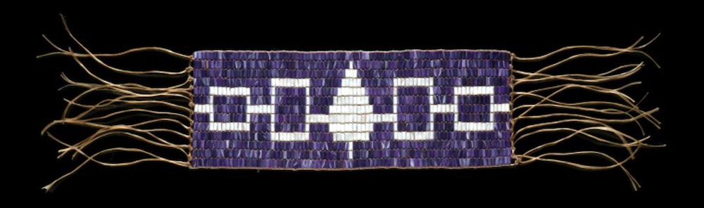
There was a landmark meeting in North America traditionally dated to 1200, though some historians say it could have been later. Iroquois chiefs of the Seneca, Cayuga, Onondaga, Oneida, and Mohawk—who had often been in deadly conflict with each other—pledged to live in peace and to unite in a confederation. It was known in the Iroquois language as the Haudenosaunee and would also come to be known as the Five Nations. The symbolic “Great Tree of Peace” where they celebrated this agreement was inspired by a white pine, whose characteristic bundle of five needles represented the tribes. Iroquois tradition attributes the meeting and its success to a man named Dekanawida, the peace-giver, with assistance of a woman named Jigonhsasee and the orator known as Hiawatha. Each tribe in the confederation pledged not to fight, ending what had been a long cycle of conflict. The agreement was recorded in the Hiawatha wampum belt.
All five tribes of the Iroquois Confederacy and how they were all woven together. Original image by Junuxx, CC BY-S
Haudenosaunee is sometimes translated as “The People of the Longhouse,” which members of the confederacy saw as a symbol of their unity. They envisioned the longhouse, with the Mohawks at the eastern door in the lower Mohawk Valley; the Oneidas occupied the upper Mohawk Valley near modern day Oneida; the Onondagas kept the council fire in the center in the greater Syracuse area; the Cayugas occupied the finger-lakes area; and the Seneca guarded the western door in the modern Rochester-Buffalo area. Each tribe relied on a matriarchal hierarchy and a men’s council to govern its people. Around 1720, the Tuscarora nation was admitted into the league as the sixth member.
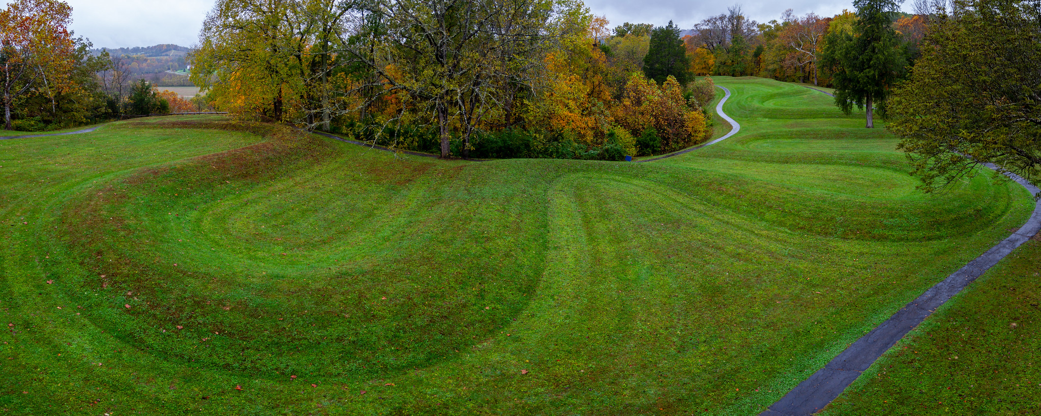
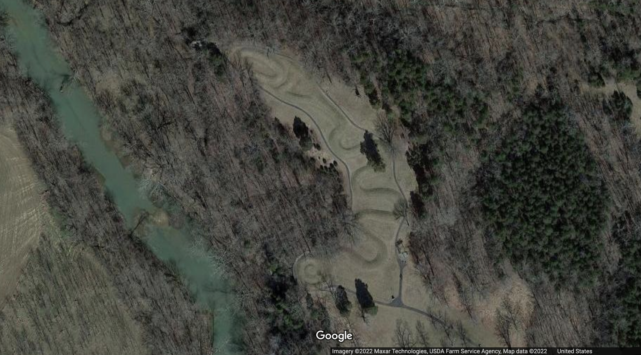
Fort Ancient Culture(?), Great Serpent Mound, c. 1070, Adams County, Ohio (photo: Arthur T. LaBar, CC BY-NC 2.0)
A serpent 1300 feet long
The Great Serpent Mound in rural, southwestern Ohio is the largest serpent effigy in the world. Numerous mounds were made by the ancient Native American cultures that flourished along the fertile valleys of the Mississippi, Ohio, Illinois, and Missouri Rivers a thousand years ago, though many were destroyed as farms spread across this region during the modern era. They invite us to contemplate the rich spiritual beliefs of the ancient Native American cultures that created them.
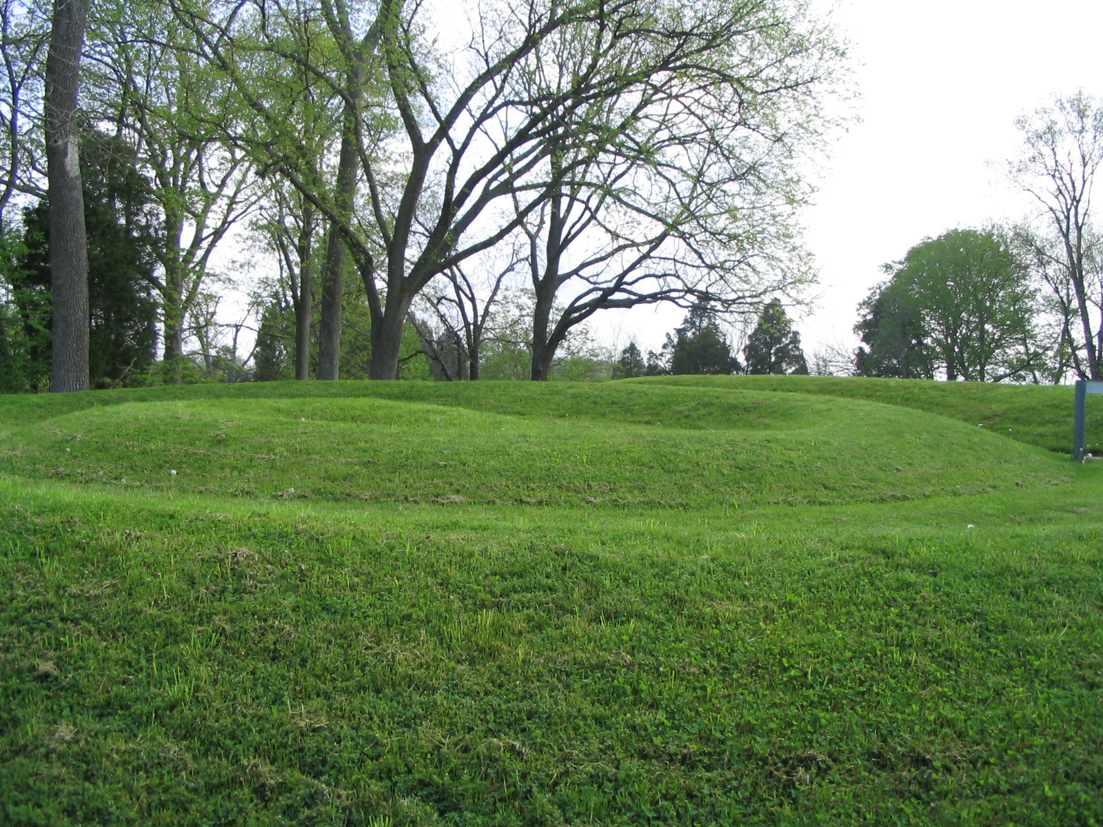
The Great Serpent Mound measures approximately 1,300 feet in length and ranges from one to three feet in height. The complex mound is both architectural and sculptural and was erected by settled peoples who cultivated maize, beans and squash and who maintained a stratified society with an organized labor force, but left no written records. Let’s take a look at both aerial and close-up views that can help us understand the mound in relationship to its site and the possible intentions of its makers.
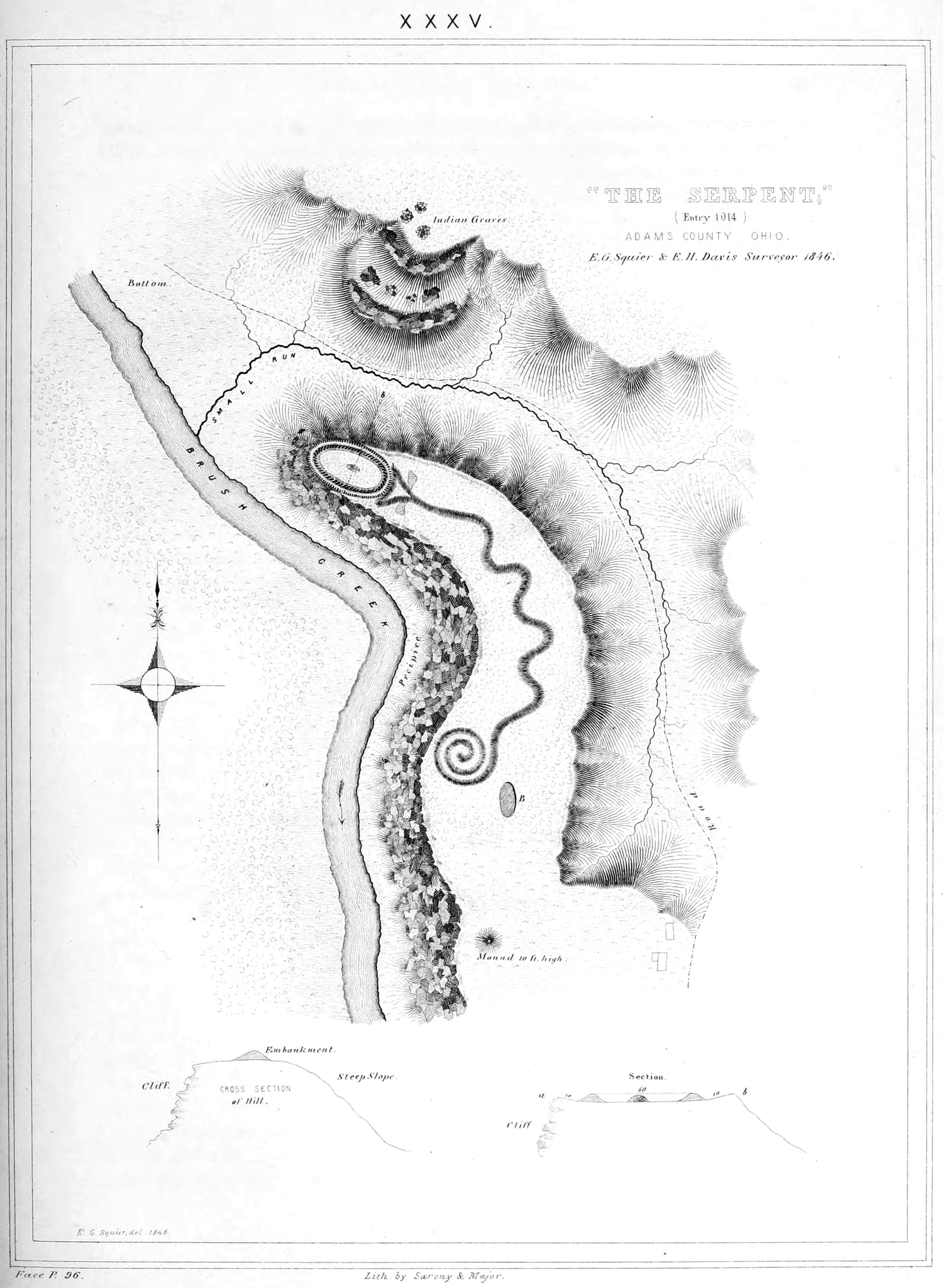
Ephraim George Squier and E. H. Davis, “The Serpent;” entry 1014, Adams County Ohio. Pl. XXXV, Ancient monuments of the Mississippi Valley: comprising the results of extensive original surveys and explorations, Washington: Smithsonian institution, 1848
Supernatural powers?
The serpent is slightly crescent-shaped and oriented such that the head is at the east and the tail at the west, with seven winding coils in between. The shape of the head perhaps invites the most speculation. Whereas some scholars read the oval shape as an enlarged eye, others see a hollow egg or even a frog about to be swallowed by wide, open jaws. But perhaps that lower jaw is an indication of appendages, such as small arms that might imply the creature is a lizard rather than a snake. Many native cultures in both North and Central America attributed supernatural powers to snakes or reptiles and included them in their spiritual practices. The native peoples of the Middle Ohio Valley in particular frequently created snake-shapes out of copper sheets.
The mound conforms to the natural topography of the site, which is a high plateau overlooking Ohio Brush Creek. In fact, the head of the creature approaches a steep, natural cliff above the creek. The unique geologic formations suggest that a meteor struck the site approximately 250–300 million years ago, causing folded bedrock underneath the mound.
Celestial hypotheses
Aspects of both the zoomorphic form and the unusual site have associations with astronomy worthy of our consideration. The head of the serpent aligns with the summer solstice sunset, and the tail points to the winter solstice sunrise. Could this mound have been used to mark time or seasons, perhaps indicating when to plant or harvest? Likewise, it has been suggested that the curves in the body of the snake parallel lunar phases, or alternatively align with the two solstices and two equinoxes.
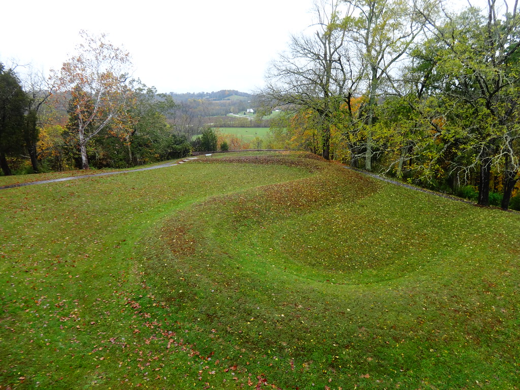
View of tail, Fort Ancient Culture(?), Great Serpent Mound, c. 1070, Adams County, Ohio (photo: The Last Cookie, CC BY 2.0)
Some have interpreted the egg or eye shape at the head to be a representation of the sun. Perhaps even the swallowing of the sun shape could document a solar eclipse. Another theory is that the shape of the serpent imitates the constellation Draco, with the Pole Star matching the placement of the first curve in the snake’s torso from the head. An alignment with the Pole Star may indicate that the mound was used to determine true north and thus served as a kind of compass.
Of note also is the fact that Halley’s Comet appeared in 1066, although the tail of the comet is characteristically straight rather than curved. Perhaps the mound served in part to mark this astronomical event or a similar phenomenon, such as light from a supernova. In a more comprehensive view, the serpent mount may represent a conglomerate of all celestial knowledge known by these native peoples in a single image.
Who built it?
Determining exactly which culture designed and built the effigy mound, and when, is a matter of ongoing inquiry. A broad answer may lie in viewing the work as being designed, built, and/or refurbished over an extended period of time by several Indigenous groups. The leading theory is that the Fort Ancient Culture (1000–1650 C.E.) is principally responsible for the mound, having erected it in c. 1070 C.E. This mound-building society lived in the Ohio Valley and was influenced by the contemporary Mississippian culture (700–1550), whose urban center was located at Cahokia in Illinois. The rattlesnake was a common theme among the Mississippian culture, and thus it is possible that the Fort Ancient Culture appropriated this symbol from them (although there is no clear reference to a rattle to identify the species as such).
View of the Great Serpent Mound, 1070(?), Adams County, Ohio (photo: VasenkaPhotography, CC BY 2.0)
An alternative theory is that the Fort Ancient Culture refurbished the site c. 1070, reworking a preexisting mound built by the Adena Culture (c.1100 B.C.E.–200 C.E.) and/or the Hopewell Culture (c. 100 B.C.E.–550 C.E.). Whether the site was built by the Fort Ancient peoples, or by the earlier Adena or Hopewell Cultures, the mound is atypical. The mound contains no artifacts, and both the Fort Ancient and Adena groups typically buried objects inside their mounds. Although there are no graves found inside the Great Serpent Mound, there are burials found nearby, but none of them are the kinds of burials typical for the Fort Ancient culture and are more closely associated with Adena burial practices. Archaeological evidence does not support a burial purpose for the Great Serpent Mound.
Debate continues
Whether this impressive monument was used as a way to mark time, document a celestial event, act as a compass, serve as a guide to astrological patterns, or provide a place of worship to a supernatural snake god or goddess, we may never know with certainty. One scholar has recently suggested that the mound was a platform or base for totems or other architectural structures that are no longer extant, perhaps removed by subsequent cultures. All to say, scholarly debate continues, based on on-going archaeological evidence and geological research. But without a doubt, the mound is singular and significant in its ability to provide tangible insights into the cosmology and rituals of the ancient Americas.
Remarkable structures in the American Southwest were home to cliff-dwelling farmers until around 1300.
Mesa Verde and the preservation of Ancestral Puebloan heritage ARCHES: At Risk Cultural Heritage Education Series. Speakers: Dr. Lauren Kilroy-Ewbank and Dr. Steven Zucker
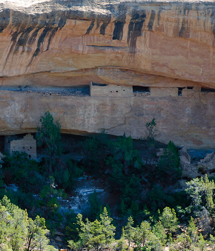
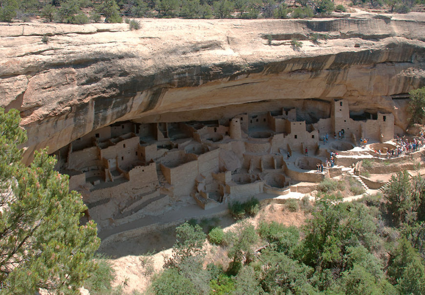
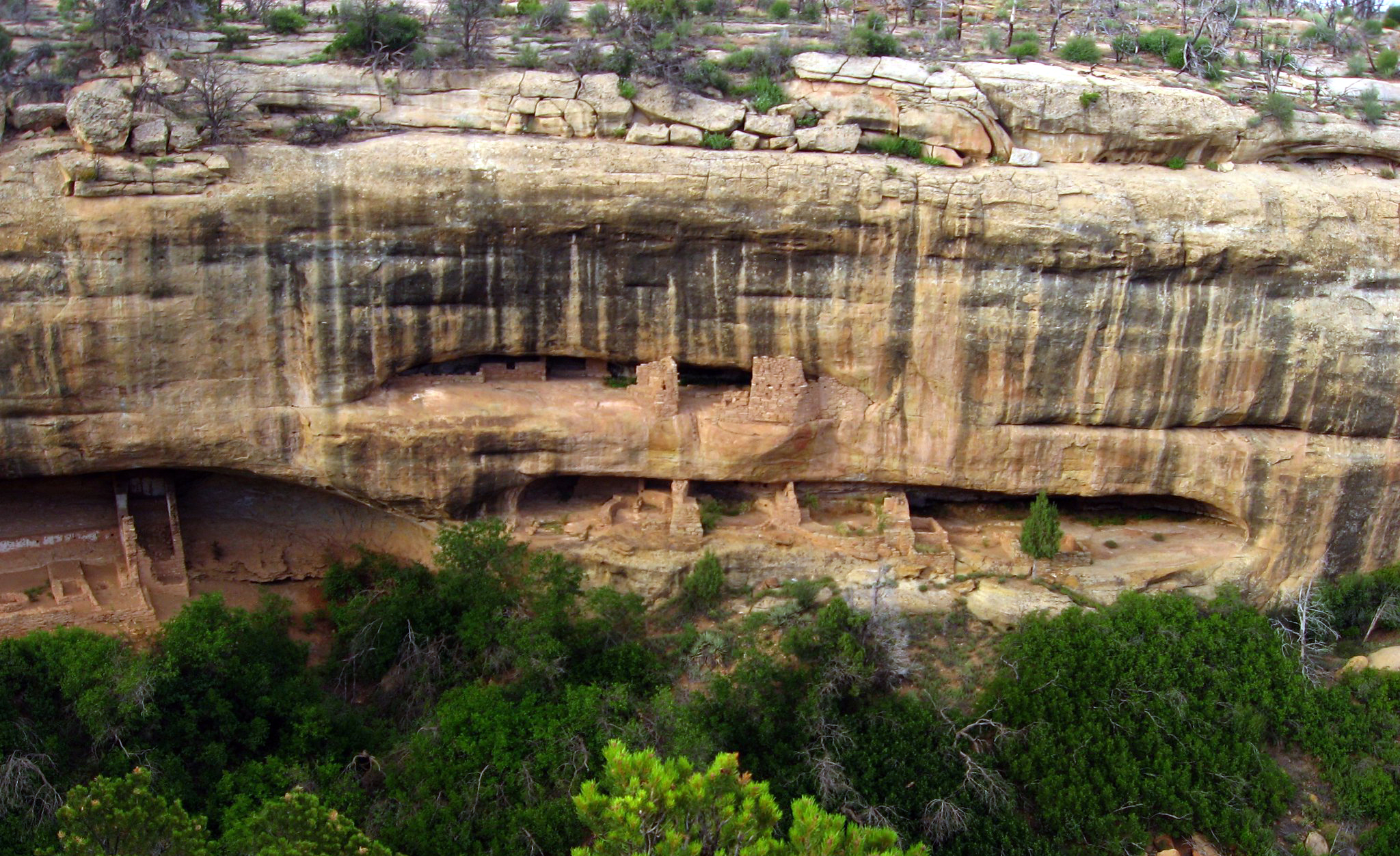
Cliff dwellings, Ancestral Puebloan, 450–1300 C.E., sandstone, Mesa Verde National Park, (photo: Steven Zucker, CC BY-NC-SA 2.0)
Imagine living in a home built into the side of a cliff. The Ancestral Puebloan peoples (formerly known as the Anasazi) did just that in some of the most remarkable structures still in existence today. Beginning after 1000–1100 C.E., they built more than 600 structures (mostly residential but also for storage and ritual) into the cliff faces of the Four Corners region of the United States (the southwestern corner of Colorado, northwestern corner of New Mexico, northeastern corner of Arizona, and southeastern corner of Utah). The dwellings depicted here are located in what is today southwestern Colorado in the national park known as Mesa Verde (“verde” is Spanish for green and “mesa” literally means table in Spanish but here refers to the flat-topped mountains common in the southwest).
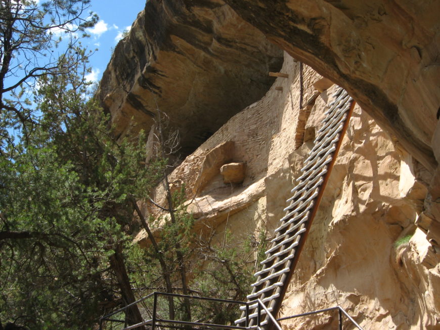
Ladder to Balcony House, Mesa Verde National Park (photo: Ken Lund, CC BY-SA 2.0)
The most famous residential sites date to the twelfth and thirteenth centuries. The Ancestral Puebloans accessed these dwellings with retractable ladders, and if you are sure footed and not afraid of heights, you can still visit some of these sites in the same way today.
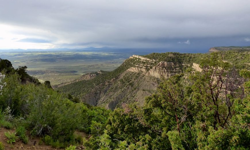
To access Mesa Verde National Park, you drive up to the plateau along a winding road. People come from around the world to marvel at the natural beauty of the area as well as the archaeological remains, making it a popular tourist destination.
The twelfth- and thirteenth-century structures made of stone, mortar, and plaster remain the most intact. We often see traces of the people who constructed these buildings, such as hand or fingerprints in many of the mortar and plaster walls.
View of a canyon, Mesa Verde National Park, Colorado (photo: FancyLady, CC BY-ND 2.0)
Ancestral Puebloans occupied the Mesa Verde region from about 450 C.E. to 1300 C.E. The inhabited region encompassed a far larger geographic area than is defined now by the national park, and included other residential sites like Hovenweep National Monument and Yellow Jacket Pueblo. Not everyone lived in cliff dwellings. Yellow Jacket Pueblo was also much larger than any site at Mesa Verde. It had 600–1200 rooms, and 700 people likely lived there (see link below). In contrast, only about 125 people lived in Cliff Palace (largest of the Mesa Verde sites), but the cliff dwellings are certainly among the best-preserved buildings from this time.
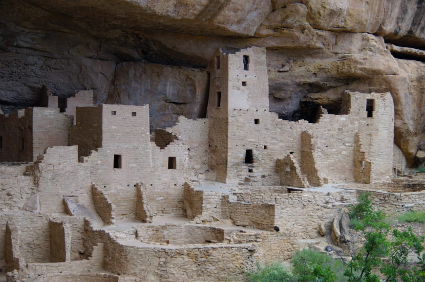
Cliff Palace, Ancestral Puebloan, 450–1300 C.E., sandstone, Mesa Verde National Park, Colorado (photo: Steven Zucker, CC BY-NC-SA 2.0)
Cliff palace
The largest of all the cliff dwellings, Cliff Palace, has about 150 rooms and more than twenty circular rooms. Due to its location, it was well protected from the elements. The buildings ranged from one to four stories, and some hit the natural stone “ceiling.” To build these structures, people used stone and mud mortar, along with wooden beams adapted to the natural clefts in the cliff face. This building technique was a shift from earlier structures in the Mesa Verde area, which, prior to 1000 C.E., had been made primarily of adobe (bricks made of clay, sand and straw or sticks). These stone and mortar buildings, along with the decorative elements and objects found inside them, provide important insights into the lives of the Ancestral Puebloan people during the thirteenth century.
View of Cliff Palace structures, Mesa Verde (photo: steeleman204, CC BY-NC-ND 2.0)
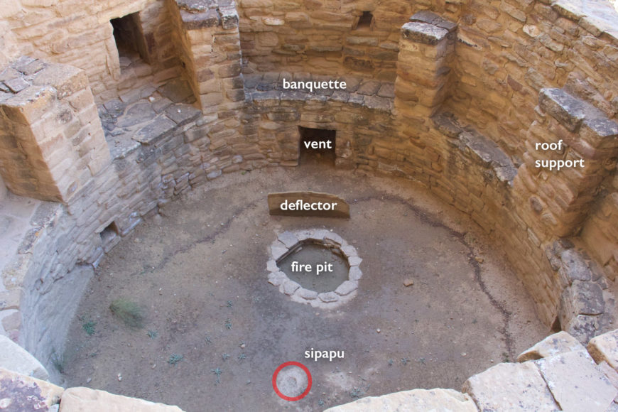
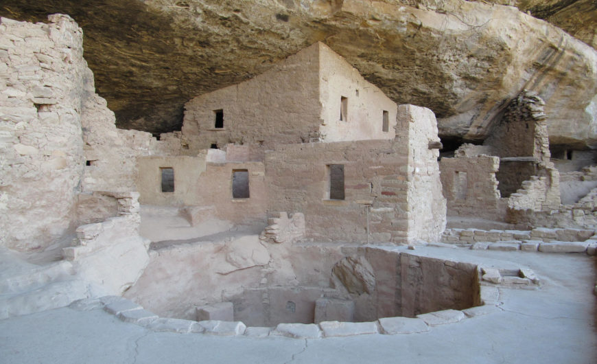
At sites like Cliff Palace, families lived in architectural units, organized around kivas (circular, subterranean rooms). A kiva typically had a wood-beamed roof held up by six engaged support columns made of masonry above a shelf-like banquette. Other typical features of a kiva include a firepit (or hearth), a ventilation shaft, a deflector (a low wall designed to prevent air drawn from the ventilation shaft from reaching the fire directly), and a sipapu, a small hole in the floor that is ceremonial in purpose. They developed from the pithouse, also a circular, subterranean room used as a living space.
Kiva without a roof, Cliff Palace, Mesa Verde National Park (photo: Adam Lederer, CC BY-NC-SA 2.0)
Kivas continue to be used for ceremonies today by Puebloan peoples though not those within Mesa Verde National Park. In the past, these circular spaces were likely both ceremonial and residential. If you visit Cliff Palace, you will see the kivas without their roofs (see above), but in the past they would have been covered, and the space around them would have functioned as a small plaza.
Cliff Palace plan with circular kivas, National Park Service
Connected rooms fanned out around these plazas, creating a housing unit. One room, typically facing onto the plaza, contained a hearth. Family members most likely gathered here. Other rooms located off the hearth were most likely storage rooms, with just enough of an opening to squeeze your arm through a hole to grab anything you might need. Cliff Palace also features some unusual structures, including a circular tower. Archaeologists are still uncertain as to the exact use of the tower.
Kiva at Spruce Tree House, Mesa Verde National Park (photo: Doug Kerr, CC BY-SA 2.0)
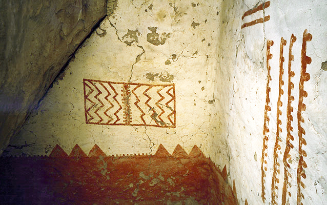
Painted murals
The builders of these structures plastered and painted murals, although what remains today is fairly fragmentary. Some murals display geometric designs, while other murals represent animals and plants.
Mural 30, Cliff Palace, Mesa Verde National Park (photo: National Park Service)
For example, Mural 30, on the third floor of a rectangular “tower” (more accurately a room block) at Cliff Palace, is painted red against a white wall. The mural includes geometric shapes that are thought to portray the landscape. It is similar to murals inside of other cliff dwellings including Spruce Tree House and Balcony House. Scholars have suggested that the red band at the bottom symbolizes the earth while the lighter portion of the wall symbolizes the sky. The top of the red band, then, forms a kind of horizon line that separates the two. We recognize what look like triangular peaks, perhaps mountains on the horizon line. The rectangular element in the sky might relate to clouds, rain or to the sun and moon. The dotted lines might represent cracks in the earth.
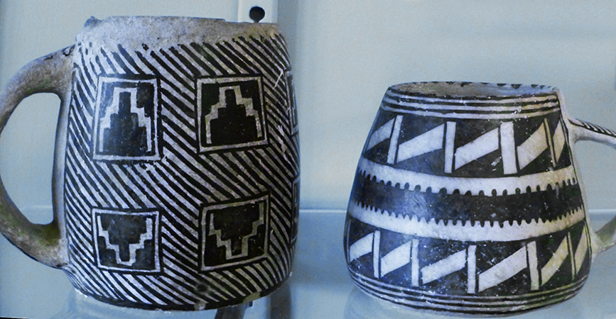
Mugs found at Mesa Verde (photo: by the author, Mesa Verde Museum)
The creators of the murals used paint produced from clay, organic materials, and minerals. For instance, the red color came from hematite (a red ocher). Blue pigment could be turquoise or azurite, while black was often derived from charcoal. Along with the complex architecture and mural painting, the Ancestral Puebloan peoples produced black-on-white ceramics and turquoise and shell jewelry (goods were imported from afar including shell and other types of pottery). Many of these high-quality objects and their materials demonstrate the close relationship these people had to the landscape. Notice, for example, how the geometric designs on the mugs above appear similar to those in Mural 30 at Cliff Palace.
Why build here?
From 500–1300 C.E., Ancestral Puebloans who lived at Mesa Verde were sedentary farmers and cultivated beans, squash, and corn. Corn originally came from what is today Mexico at some point during the first millennium of the Common Era. Originally most farmers lived near their crops, but this shifted in the late 1100s when people began to live near sources of water, and often had to walk longer distances to their crops.
New Fire House, Masa Verde National Park (photo: Ken Lund, CC BY-SA 2.0)
So why move up to the cliff alcoves at all, away from water and crops? Did the cliffs provide protection from invaders? Were they defensive or were there other issues at play? Did the rock ledges have a ceremonial or spiritual significance? They certainly provide shade and protection from snow. Ultimately, we are left only with educated guesses—the exact reasons for building the cliff dwellings remain unknown to us.
Why were the cliffs abandoned?
The cliff dwellings at Mesa Verde were abandoned around 1300 C.E. After all the time and effort it took to build these beautiful dwellings, why did people leave the area? Cliff Palace was built in the twelfth century, why was it abandoned less than a hundred years later? These questions have not been answered conclusively, though it is likely that the migration from this area was due to either drought, lack of resources, violence or some combination of these. We know, for instance, that droughts occurred from 1276 to 1299. These dry periods likely caused a shortage of food and may have resulted in confrontations as resources became more scarce. The cliff dwellings remain, though, as compelling examples of how the Ancestral Puebloans literally carved their existence into the rocky landscape of today’s southwestern United States.
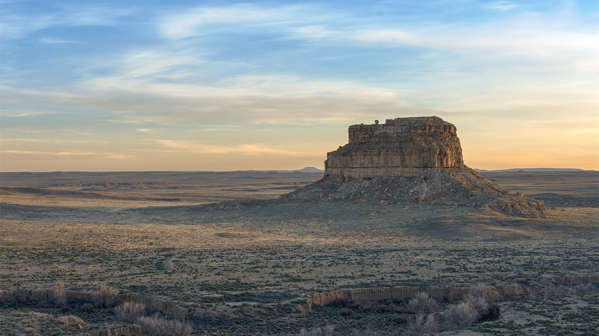
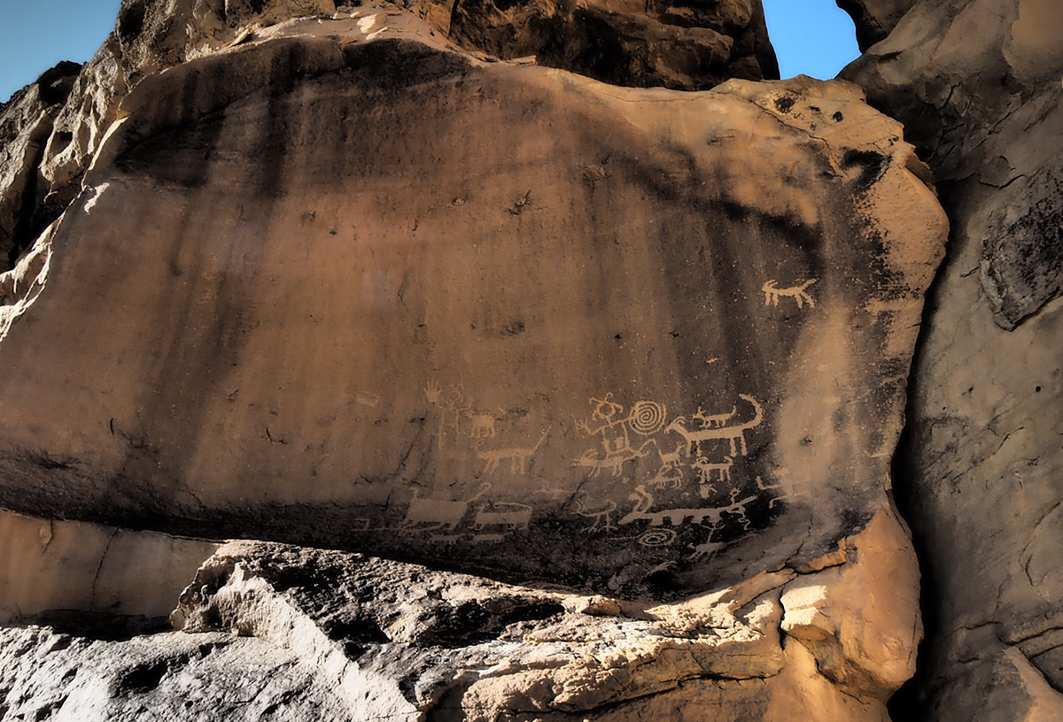
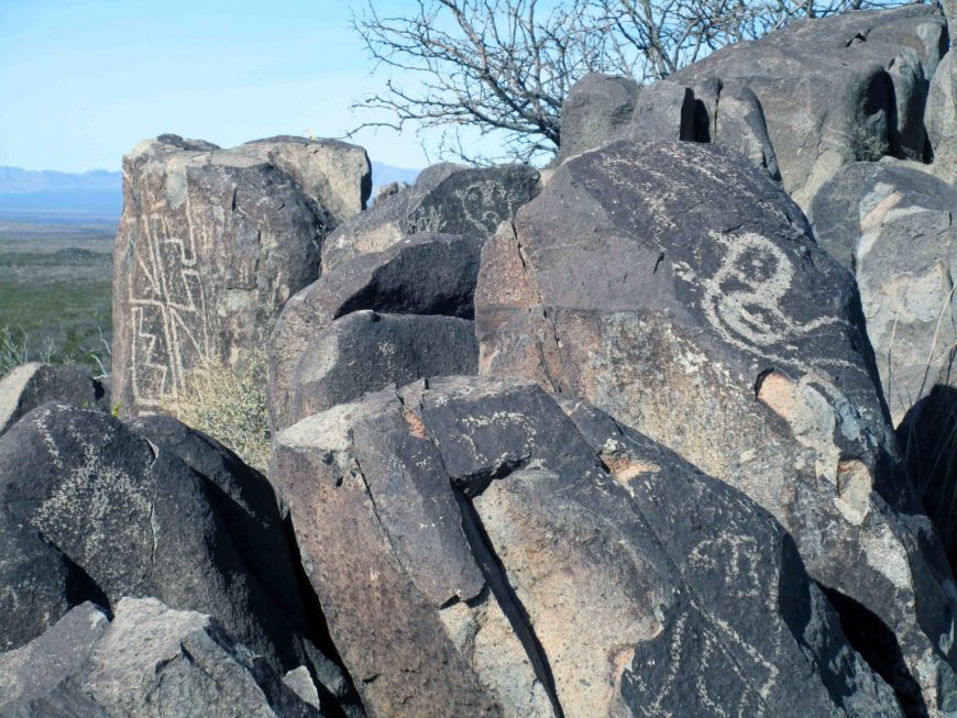
Fajada Butte, Chaco Canyon, New Mexico. Chacoan petroglyphs can be found at the base of the cliffs (photo: Adam Meek, CC BY 2.0)
New Mexico is known as the “land of enchantment.” Among its many wonders, Chaco Canyon stands out as one of the most spectacular. Part of Chaco Culture National Historical Park, Chaco Canyon is among the most impressive archaeological sites in the world, receiving tens of thousands of visitors each year. Chaco is more than just a tourist site however, it is also sacred land. Pueblo peoples like the Hopi, Navajo, and Zuni consider it a home of their ancestors.
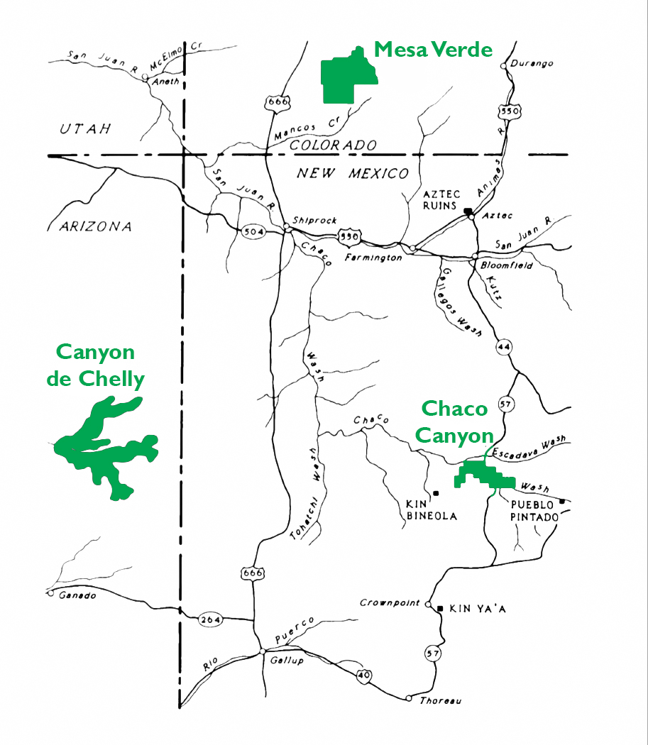
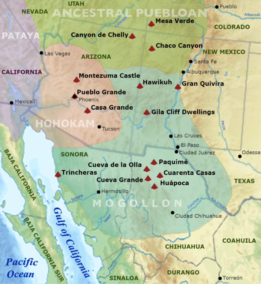
Map of major ancestral Puebloan sites in the Four Corners region (National Park Service)
The canyon is vast and contains an impressive number of structures—both big and small—testifying to the incredible creativity of the people who lived in the Four Corners region of the U.S. between the 9th and 12th centuries. Chaco was the urban center of a broader world, and the ancestral Puebloanswho lived here engineered striking buildings, waterways, and more.
Petroglyphs, Chaco Canyon (photo: KrisNM, CC BY-NC-ND 2.0)
Chaco is located in a high, desert region of New Mexico, where water is scarce. The remains of dams, canals, and basins suggest that Chacoans spent a considerable amount of their energy and resources on the control of water in order to grow crops, such as corn. Today, visitors have to imagine the greenery that would have filled the canyon.
Astronomical observations clearly played an important role in Chaco life, and they likely had spiritual significance. Petroglyphs found in Chaco Canyon and the surrounding area reveal an interest in lunar and solar cycles, and many buildings are oriented to align with winter and summer solstices.
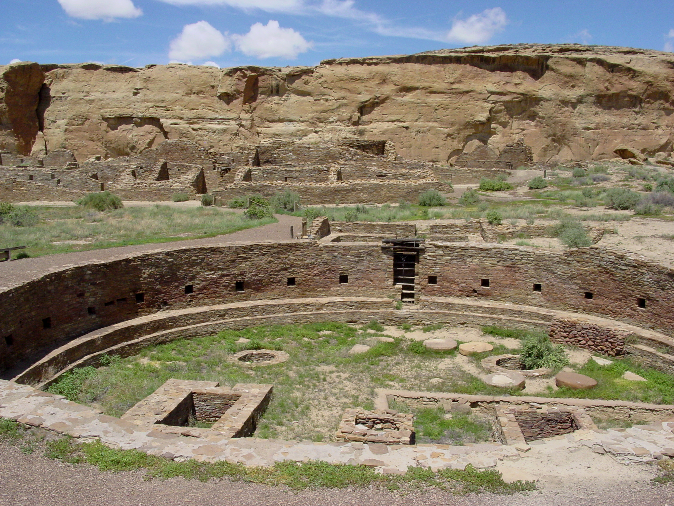
The great kiva at Chetro Ketl, Chaco Canyon, New Mexico (National Park Service)
Great Houses
“Downtown Chaco” features a number of “Great Houses” built of stone and wood. Most of these large complexes have Spanish names, given to them during expeditions, such as one sponsored by the U.S. army in 1849, led by Lt. James Simpson. Carabajal, Simpson’s guide, was Mexican, which helps to explain some of the Spanish names. Great Houses also have Navajo names, and are described in Navajo legends. Tsebida’t’ini’ani (Navajo for “covered hole”), nastl’a kin (Navajo for “house in the corner”), and Chetro Ketl (a name of unknown origin) all refer to one great house, while Pueblo Bonito (Spanish for “pretty village”) and tse biyaa anii-ahi (Navajo for “leaning rock gap”) refer to another.
Pueblo Bonito, Chaco Canyon, New Mexico (photo: Paul Williams, CC BY-NC 2.0)
Multistoried rooms, Pueblo Bonito, Chaco Canyon, New Mexico (photo: Jacqueline Poggi, CC BY-NC-ND 2.0)
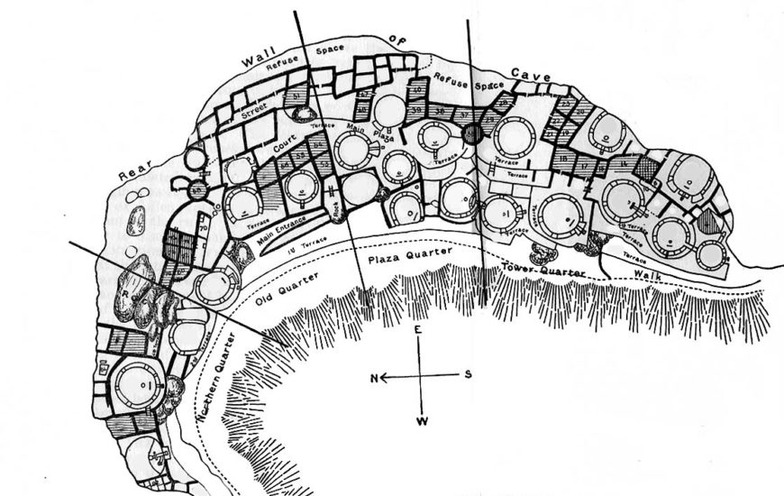
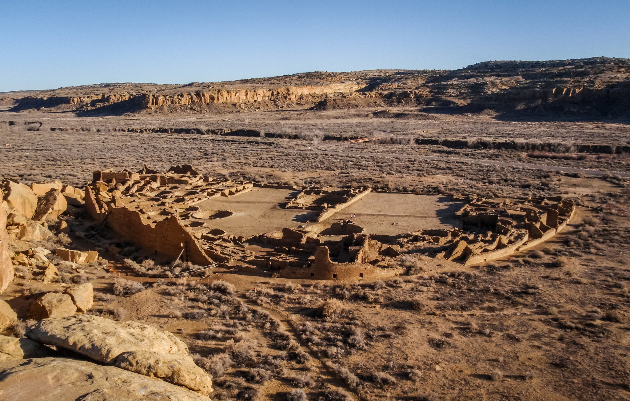
Pueblo Bonito is among the most impressive of the Great Houses. It is a massive D-shaped structure that had somewhere between 600 and 800 rooms. It was multistoried, with some sections reaching as high as four stories. Some upper floors contained balconies.
There are many questions that we are still trying to answer about this remarkable site and the people who lived here. A Great House like Pueblo Bonito includes numerous round rooms, called kivas. This large architectural structure included three great kivas and thirty-two smaller kivas. Great kivas are far larger in scale than the others, and were possibly used to gather hundreds of people together. The smaller kivas likely functioned as ceremonial spaces, although they were likely multi-purpose rooms.
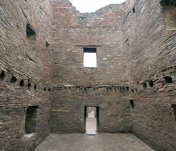
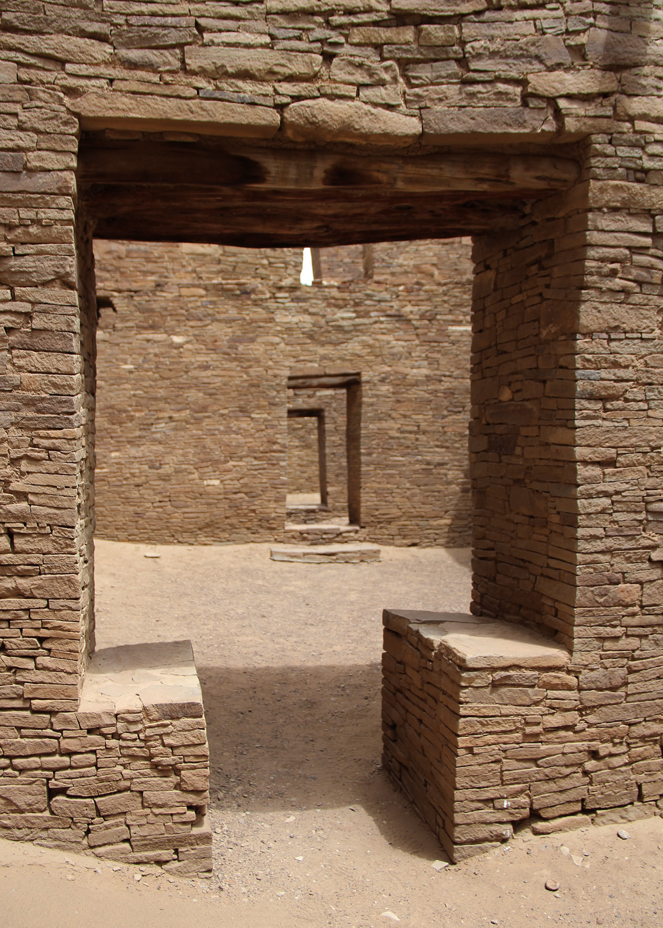
Doorway, Pueblo Bonito, Chaco Canyon (photo: Thomson20192, CC BY 2.0)
Among the many remarkable features of this building are its doorways, sometimes aligned to give the impression that you can see all the way through the building. Some doorways have a T shape, and T-shaped doors are also found at other sites across the region. Research is ongoing to determine whether the T-shaped doors suggest the influence of Chaco or if the T-shaped door was a common aesthetic feature in this area, which the Chacoans then adopted.
Recently, testing of the trees (dendroprovenance) that were used to construct these massive buildings has demonstrated that the wood came from two distinct areas more than 50 miles away: one in the San Mateo Mountains, the other the Chuska Mountains. About 240,000 trees would have been used for one of the larger Great Houses.
Chacoan Cultural Interactions
Traditionally, we tend to separate Mesoamerica and the American Southwest, as if the peoples who lived in these areas did not interact. We now know this is misleading, and was not the case.
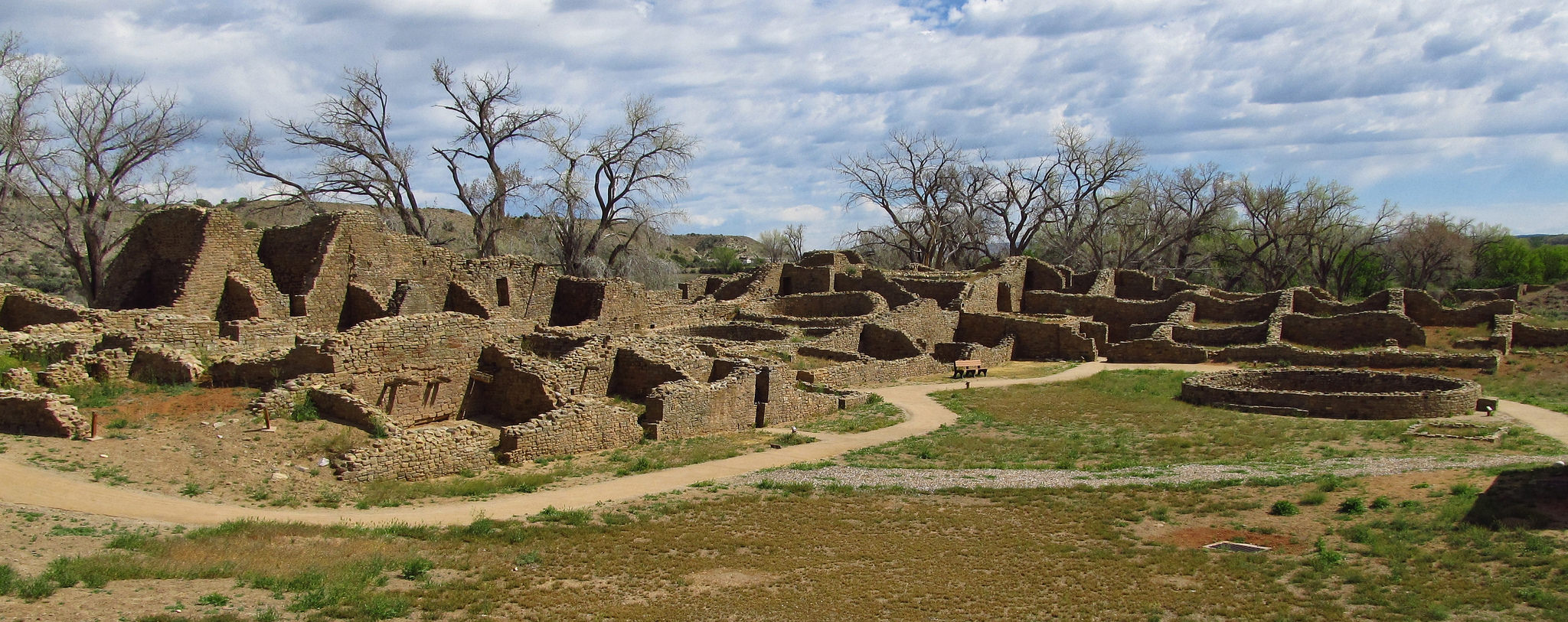
Chacoan culture expanded far beyond the confines of Chaco Canyon. Staircases leading out of the canyon allowed people to climb the mesas and access a vast network of roads that connected places across great distances, such as Great Houses in the wider region. Aztec Ruins National Monument (not to be confused with ruins that belonged to the Aztecs of Mesoamerica) in New Mexico is another ancestral Puebloan site with many of the same architectural features we see at Chaco, including a Great House and T-shaped doorways.
Aztec Ruins National Monument, New Mexico (photo: Jasperdo, CC BY-NC-ND 2.0)
Cylindrical Jar from the Pueblo Bonito, Chaco Canyon, New Mexico, 3 5/8 inches in diameter (National Anthropological Archives, Smithsonian Institution)
Archaeological excavations have uncovered remarkable objects that animated Chacoan life and reveal Chaco’s interactions with peoples outside the Southwestern United States. More than 15,000 artifacts have been unearthed during different excavations at Pueblo Bonito alone, making it one of the best understood spaces at Chaco. Many of these objects speak to the larger Chacoan world, as well as Chaco’s interactions with cultures farther away. In one storage room within Pueblo Bonito, pottery sherds had traces of cacao imported from Mesoamerica. These black-and-white cylindrical vessels were likely used for drinking cacao, similar to the brightly painted Maya vessels used for a similar purpose.
The remains of scarlet macaws, birds native to an area in Mexico more than 1,000 miles away, also reveal the trade networks that existed across the Mesoamerican and Southwestern world. We know from other archaeological sites in the southwest that there were attempts to breed these colorful birds, no doubt in order to use their colorful feathers as status symbols or for ceremonial purposes. A room with a thick layer of guano (bird excrement) suggests that an aviary also existed within Pueblo Bonito. Copper bells found at Chaco also come from much further south in Mexico, once again testifying to the flourishing trade networks at this time. Chaco likely acquired these materials and objects in exchange for turquoise from their own area, examples of which can be found as far south as the Yucatan Peninsula.
Current Threats to Chaco
The world of Chaco is threatened by oil drilling and fracking. After President Theodore Roosevelt passed the Antiquities Act of 1906, Chaco was one of the first sites to be made a national monument. Chaco Canyon is also a UNESCO World Heritage Site. The Chacoan region extended far beyond this center, but unfortunately the Greater Chacoan Region does not fall under the protection of the National Park Service or UNESCO. Much of the Greater Chaco Region needs to be surveyed, because there are certainly many undiscovered structures, roads, and other findings that would help us learn more about this important culture. Beyond its importance as an extraordinary site of global cultural heritage, Chaco has sacred and ancestral significance for many Native Americans. Destruction of the Greater Chaco Region erases an important connection to the ancestral past of Native peoples, and to the present and future that belongs to all of us.
Source: Dr. Lauren Kilroy-Ewbank, “Introduction to Chaco Canyon,” in Smarthistory, April 13, 2018, accessed August 20, 2024, https://smarthistory.org/chaco/.
Introduction to Mogollon
by Dr. Lauren Kilroy-Ewbank
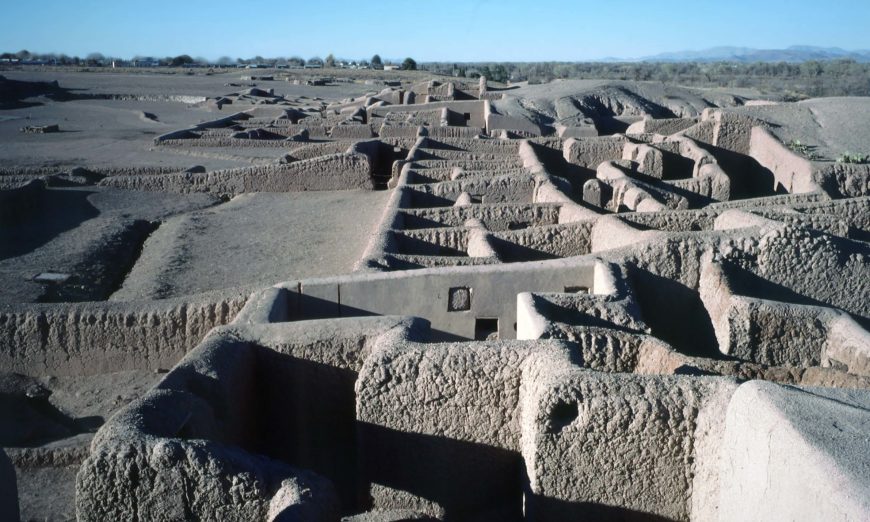
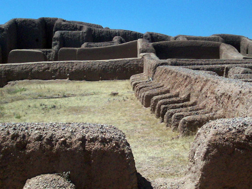
Residential areas, Paquimé (Casas Grandes), c. 1150–1350 C.E., Chihuahua, Mexico (photo: HJPD, CC BY-SA 3.0)
Shell ornaments, copper bells, rubber balls, and macaws are only some of the remarkable finds from the archaeological site of Paquimé (also known as Casas Grandes) in northern Mexico. Some of these things traveled on long-distance trade networks that ran from southern Mesoamerica to what is now the southwestern United States, and west to the Gulf of California. Paquimé was a large city filled with several thousand people that flourished for two centuries, from c. 1150 until about 1350 C.E. It is one of many sites associated with the Mogollon tradition (c. 200–1450 C.E.).
Who and where were the Mogollon?
Regions of ancient regional tribes in the southwestern United States and northwestern Mexico (Ricraider, CC BY 3.0)
The Mogollon cultural area spanned across what is today northern Mexico into Arizona and New Mexico. Archaeologists named the Mogollon cultural group after a mountain range in southern New Mexico centuries later. While there are traits that characterize the broader Mogollon tradition, there were distinct features found among six more localized regions (Mimbres, Black River, San Simon, Jornada, Pine Lawn, and Forestdale) in the larger cultural area.
In addition to the Mogollon, the Greater Southwest region included the Hohokam, Ancestral Puebloan, Patayan, and Sinagua cultures. While today scholars tend to discuss them as distinct, it is likely that they are different regional variations and were more entangled than these modern-day divisions suggest.
For reasons still debated, the Mogollon disappear from the archaeological record in the mid-15th century, likely the result of them joining with Pueblo or Hopi villages. Today, multiple Native groups claim descent from the Mogollon or are intertwined with their history, including Zuni, Hopi, Acoma, and the Rarámuri (in Mexico). Apache peoples migrated into the Mogollon area after the 15th century—around the time that the Mogollon stopped appearing in the archaeological record.
Architecture
Existing archaeological evidence indicates that early on, small Mogollon communities were clustered on hilltops in pithouses. These were circular or oval rooms dug into the ground, which helped to maintain a comfortable temperature. Mogollon people practiced agriculture (primarily growing maize, beans, and squash), but also relied on hunting and foraging. Later on, as their numbers grew and they became an even more diverse group, they settled in other types of areas, including valleys. Around the year 1000, Mogollon peoples began to build above ground and made square living spaces. We also find large round ceremonial rooms that have been called “great kivas” beginning around 850, and which could accommodate large gatherings. These great kivas are on a scale similar to the Ancestral Puebloan city of Chaco to the north, which possibly served as a source. The Mogollon great kivas do not include limited entry points that restrict access to them as at Chaco—perhaps suggesting fewer hierarchical social divisions among the Mogollon.
The exact reasons for transformations (such as building above ground) are still debated.
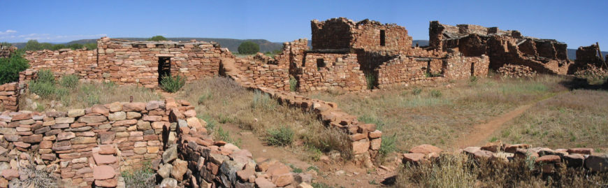
Kinishba, today on Fort Apache Indian Reservation, AZ (photo: salmonboy, CC0)
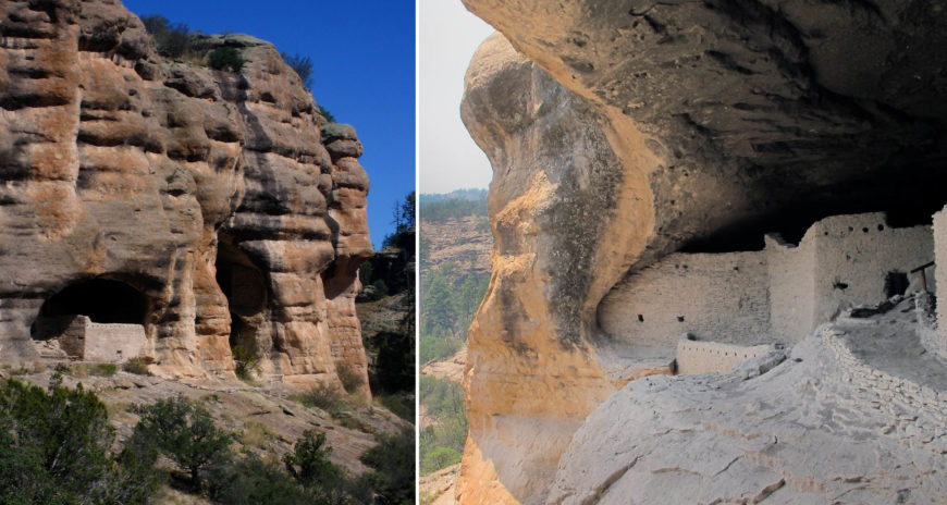
Shared forms, including architectural features, identifiable among the Mogollon, Ancestral Puebloan, and Hohokam peoples indicate they interacted. When Puebloan peoples migrated south in the 13th century—most likely due to drought—we find increased evidence of influence from Puebloan cultures and indicators of Mogollon and Puebloan cohabitation. Sites like Kinishba and Gila Cliff Dwellings (began after 1270) show the influence of Puebloan architectural features. For example, rather than pithouses, we now find above-ground villages built with stone as well as cliff dwellings—both characteristic of their Pueblo neighbors.
Gila Cliff Dwellings (left photo: Christopher Holden, CC BY-SA 2.0; right photo: cudinski, CC BY-NC 2.0)
Migrations were an important aspect of life at this time, and Pueblo peoples today speak about their ancestors’ migrations, such as the search for the Middle Place. As is clear from what took place in the Greater Southwestern region, people were on the move. The architectural remains of communities at Kinishba and Gila Cliff Dwellings are footprints of these past movements, connecting contemporary Native communities to their ancestors.
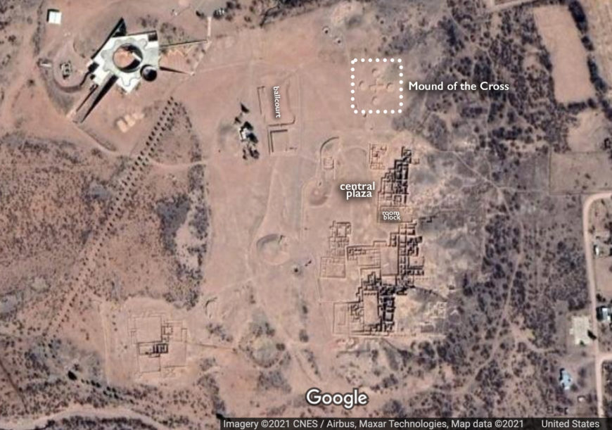
The city of Paquimé, largely built of adobe, would have rivaled other large cities and settlements of the region such as Chaco (which flourished earlier). It had large plazas and marketplaces; big domestic, multistory structures to accommodate its once sizable population (some buildings had 1000+ rooms); at least two ball courts; and platform mounds. One mound, called the Mound of the Cross, has a cross-shaped platform that is oriented toward the four cardinal directions, suggesting it played an astronomical or calendrical role perhaps to track equinoxes and solstices. The exact function of most mounds remains unknown. Feasting areas are filled with huge ovens to be able to cook for large numbers of people. A complex water system brought water from miles away to a reservoir, from where water flowed to the city.
While today the walls of buildings are earthen colored, they were once painted—as was indicated by the Spaniard Baltasar de Obregón, who first saw Paquimé in 1565, after the city was abandoned:
[There are] many houses of great size, strength, and height. They are about six and seven stories. . . . The houses contain large and magnificent patios paved with enormous and beautiful stones resembling jasper . . . and pillars of heavy timber brought from far away. The walls of the houses were whitewashed and painted in many colors.Baltasar de Obregón [1]
Earlier archaeologists believed Paquimé was an outpost for Mesoamerican peoples (such as the Toltec) but that idea is no longer widely supported. Still, there is clear evidence for long-distance trade with Mesoamerica and the influence of ideas and practices (such as the ballgame), but also trade with coastal regions and those to the east. Macaws, brought from far south, were not only brought here, but the people of Paquimé bred them as revealed by pens found along the plazas (turkeys were also bred here). Shell and copper were imported. We also find iconographic elements popular in Mesoamerica, such as a plumed or horned serpent. Turquoise that was traded south into Mesoamerica moved through Paquimé. The city participated in a network of sites that traded and interacted with one another across vast distances for prestige materials and desired resources.
Paquimé is typically associated with Mogollon culture, but it also had connections to developments in what is today El Paso, Texas. Some consider it a Mogollon city, while others hold that it had its own unique culture and simply traded and interacted with Mogollon people. Paquimé also shares cultural features with Chaco, leading archaeologist Steven Lekson to argue that Chacoan elites established Paquimé after migrating south. The two sites (along with the site of Aztec in New Mexico—not to be confused with the Mexica/Aztec culture) are close to the same meridian line (what Lekson has dubbed the Chaco Meridian), suggesting that people intentionally sought to connect them. Regardless of which of these ideas is true, Paquimé certainly was the largest, most complex city associated with the Mogollon tradition.
For reasons that remain elusive, Paquimé seems to have been abandoned after 1400. Despite the city’s size and complexity, it has been much less studied than sites within U.S. borders—despite being part of the Greater Southwest region—and is a reminder that modern-day nation state boundaries have implications for what and how things are studied.
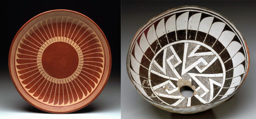
Mimbres bowls, c. 8th–12th century. Left: Bowl, c. 1000–1200, clay, slip, paint, 13 cm high, 27.9 cm in diameter (The Metropolitan Museum of Art); center: Bowl, c. 850–1050, clay, slip, paint, 8.3 cm high, 55.9 cm in diameter (The Metropolitan Museum of Art); right: Bowl, c. 1000–1200, clay, slip, paint, 11 x 24 cm (NMAI, New York)
Mimbres pottery
Bowl, Mogollon (Mimbres), 1100–1400, clay, slip, paint, 10.2 x 26.7 cm (Detroit Institute of Arts)
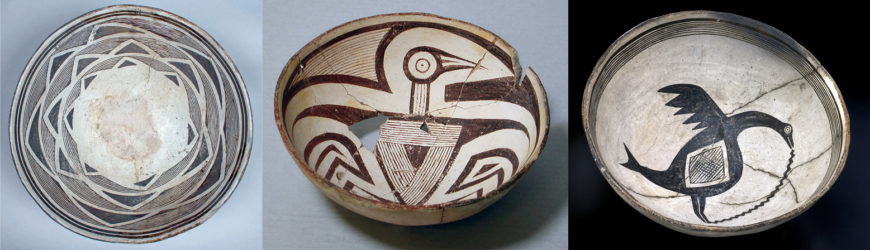
Mogollon ceramics are some of the finest examples of pottery from the Greater Southwest region. Pottery initially took the form of red-on-brown or plain brown wares before black-on-white (black paint on white slip) became popular by 1000. Mogollon pottery makers used a coil and scrape technique, created by coiling the clay, then scraping the exterior and interior to join the coils together, and finally creating a smooth surface.
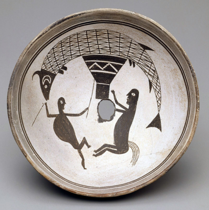
There are different types of Mogollon pottery, but the tradition associated with Mimbres culture is the most well-known. Classic Mimbres pottery (1000–1150) has some of the most inventive and diverse subject matter depicted on it, ranging from geometric patterns to narratives with figures; the latter have sometimes been called “story bowls.” Animals and birds of wonderful variety grace the bowls, as do humans who fight, farm, hunt, give birth, and many other activities. Hybrid or sacred creatures, such as horned serpents or animal-human hybrids adorn Mimbres pottery.
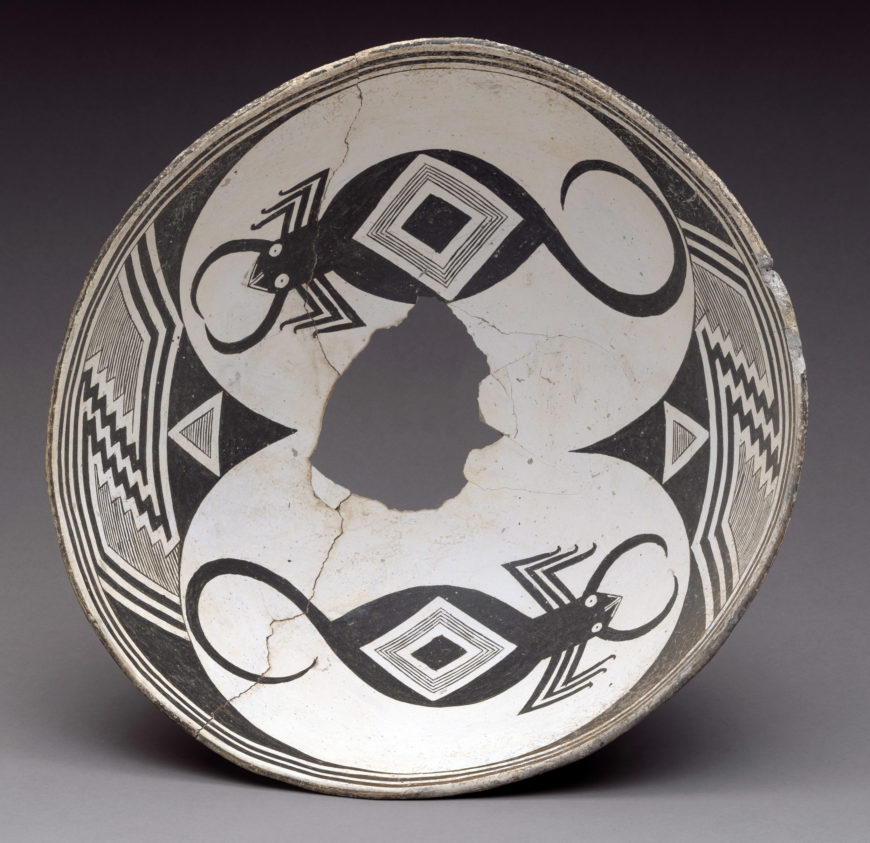
Bowl with scorpions, c. 950–1150 C.E., Mogollon (Mimbres), ceramic and pigment, 14.9 cm high, 34.6 cm in diameter (The Metropolitan Museum of Art)
In one we see two scorpions, their tails looping backwards towards their bodies, with their eyes wide open. Abstract patterns surround the black arachnids, both of which are set on a white background. The artist used the shape of the bowl to her advantage, positioning the scorpions so that they “read” clearly. She also created precise forms and a balanced composition, positioning the scorpions and abstract designs on opposite sides of the bowl. The black arachnids are set against a field of white, drawing our eye to them, at the same time that the abstract designs frame the fields of white.
Bowl with scorpions, c. 950–1150 C.E., Mogollon (Mimbres), ceramic and pigment, 14.9 cm high, 34.6 cm in diameter (The Metropolitan Museum of Art)
Typically painted on hemispheric bowls, Mimbres pottery survives in great numbers—more than 10,000 bowls survive—and many are found largely intact. The bowls were found in burials, but because they were desired as artistic objects, were removed from these graves, with little concern for the deceased ancestors and their family members and communities.
Many Mimbres bowls show light wear-and-tear, suggesting they were used (possibly in food preparation) before going underground. Most of the bowls have a hole in the base of the bowl, such as we see in the bottom of the scorpion bowl. While we do not know the exact purpose of the hole, two possibilities are that it aided the soul of the deceased by providing a path or that the hole silenced the life force or spirit of the bowl. The bowl was often placed over the face of the deceased, which echoes contemporary Pueblo accounts of the dead going to the dome of the sky as spirits. [1]
Left: María Martinez and Popovi Da (both from San Ildefonso Pueblo), Plate with radiating feather design, 1960s, ceramic, 5.08 cm high, 40.64 cm in diameter (Dallas Museum of Art); right: Bowl, Mogollon (Mimbres), c. 1000–1150, ceramic, slip, and paint, 15.6 cm high, 29.84 cm in diameter (Dallas Museum of Art)Left: María Martinez and Popovi Da (both from San Ildefonso Pueblo), Plate with radiating feather design, 1960s, ceramic, 5.08 cm high, 40.64 cm in diameter (Dallas Museum of Art); right: Bowl, Mogollon (Mimbres), c. 1000–1150, ceramic, slip, and paint, 15.6 cm high, 29.84 cm in diameter (Dallas Museum of Art)
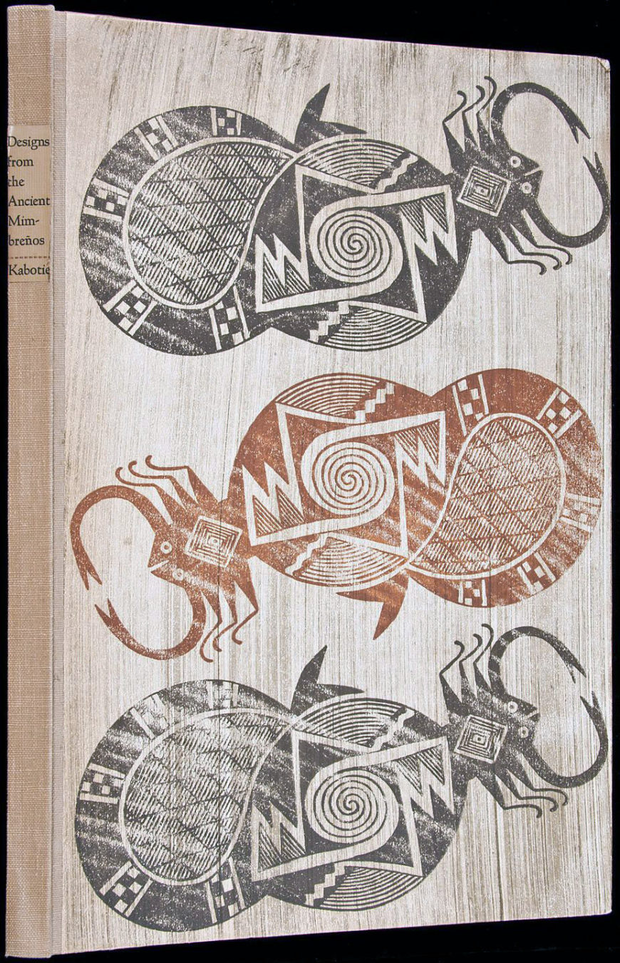
Multiple early 20th-century Native artists and textile makers have found inspiration in and connections with Mimbres pottery, including Maria and Julian Martinez and their son Popovi Da and grandson Tony Da from San Ildefonso Pueblo, Hopi artist Fred Kabotie, Joe Herrera (also known as See Ru; Cochiti Pueblo), Lucy Lewis (from Acoma Pueblo), and Anishinaabe/Ojibwe artist Carl Beam. For example, a bowl by Popovi Da has radiating feathers that replicate the rhythmic geometric patterning of some Mimbres bowls, yet demonstrates the adaptability of the tradition by 20th-century Native artists. Kabotie wrote and illustrated a book called Designs from the Ancient Mimbreños with a Hopi Interpretation, which looked to the ways in which Hopi and Mimbres designs and ideas intersected.
Unfortunately, many Mimbres bowls were looted in the late nineteenth and early twentieth centuries. As more Euro-Americans came to the region, they began to dig up the pots. The desecration was so extreme that most Mimbres villages—of which there are about 900 examples—were heavily damaged or destroyed. Besides looting, forgeries also became common.
By the 1930s, Mimbres bowls were so famous that when they traveled to Europe, some, such as the anthropologist Albert Jenks, pronounced them to be “unquestionably superior to Greeks in the field of Geometric Art.” [2] This quote suggests that people compared Mimbres to ancient Greek art as a way to elevate this Native American group, but also to position America’s history over Europe’s. The bowls became evidence of civilized peoples living in the U.S. before it was colonized by settlers, although simultaneously, people characterized the rest of the southwest area as “primitive”—and so understood Mimbres as different, as “an isolated artistic miracle.” [3] They became what art historians Janet Catherine Berlo and Ruth B. Philips call an “emblem of Indianness” along with Northwest Coast totem poles and Plains war bonnets. [4]
Mimbres vessels also became championed as bold sources for modern design, and were included in exhibitions such as the Museum of Modern Art’s 1941 Indian Art of the United States—their designs were even painted on the walls. Even today, many museum collections and exhibitions showcase Mimbres bowls, with little of the rest of Mogollon art visible or heralded.
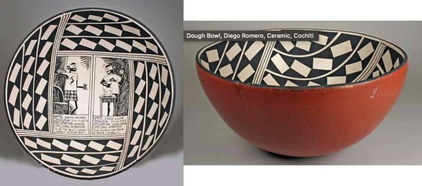
Diego Romero (Cochiti Pueblo), Dough Bowl, 1994, ceramic, 14.3 cm high, 30.5 cm in diameter (The Metropolitan Museum of Art)
Today Native artists continue to find inspiration in Mimbres pottery, including Cochiti artist Diego Romero. His Dough Bowl combines an aesthetic adapted from Mimbres bowls with imagery from popular culture. Two figures appear in the center, with text below stating their name, census number, and occupation, with a statement about their lifelong ambition. It is intended to be comical, biting commentary on contemporary Native issues. [5]
Mimbres bowls have become so ubiquitously associated with this region, that they also appear on place settings, aprons, postcards, and more. They were even part of a stamp set from the US Postal Service in 2004.
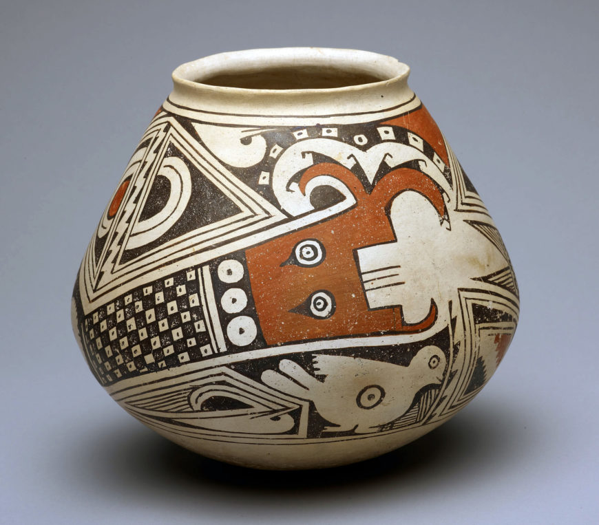
Jar with Two Plumed or Horned Serpents with Birds and P-shaped Motifs, 1280–1450, ceramic and pigment, Paquimé (Casas Grandes), Ramos Polychrome, New Mexico, U.S. or Chihuahua, Mexico, 21.6 x 24.1 cm (Art Institute of Chicago)
Paquimé ceramics
The pottery affiliated with Paquimé demonstrates the wide variety of vessels in the Mogollon region. It began c. 1250 and lasted for the next two hundred years. Unlike Classic Mimbres bowls, Paquimé ceramics appear in a variety of different shapes and sizes (such as tripods, globular jars, bowls, and more), and are polychromed. Like Classic Mimbres, they display both geometric abstraction and figural forms. In one, two horned serpents zig-zag across the elaborate surface, their head and horns painted red. Their bodies are covered in black-and-white checkerboard designs, mimicking the scales of a serpent.
Horned or feathered serpents decorate not only pottery but also rock art and kiva murals. The horned serpent is not unique to Mogollon, but is found in Ancestral Puebloan regions as well. Among Pueblo groups today, the horned serpent is an important deity (going by different names depending on the linguistic group) associated with water. They are liminal beings who can move into the earth as well as slither on top of it. The horned serpent also relates to feathered serpents, with the horns possibly relating to plumes; the avian association is likewise important because birds could move between the surface of the earth and the sky.
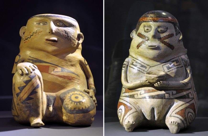
Male effigy figure, Paquimé (Casas Grandes), Ramos polychrome, c. 1200–1450 (Musées Royaux d’Art et d’Histoire, Brussels); right: Female effigy figure, Paquimé (Casas Grandes), Ramos polychrome, c. 1200–1450 (Musées Royaux d’Art et d’Histoire, Brussels)
We also find jars modeled into figural shapes, such as humans or animals. Seated male and female figures (what we now call effigy figures) are common, and are thought to convey ideas about gendered principles. Their genitalia are always displayed and often accentuated with design and color. Male figures tend to sit with one bent knee, while women sit with both legs straight. Women sometimes have protruding bellies or are shown with children, which has prompted scholars to think that they may have symbolized ideas about fertility. The bodies of figures often display elaborate designs—does this suggest that people had tattoos? Painted their bodies? Or does the bodily adornment of the effigies suggest something else? Researchers are not certain, but it does seem important that figures are also adorned with different types of clothing and accoutrements, such as necklaces, bracelets, ear ornaments, and armbands. The bodily decorations, clothing, and accoutrements may have signified different social ranks.
Twentieth-century artists have likewise been inspired by Casas Grandes pottery, such as Juan Quezada Celado of Mata Ortiz, Chihuahua. After encountering and studying pottery fragments, he taught himself how to pair what he saw with his own modernist impulses. The town of Mata Ortiz went on to develop a robust local pottery tradition in conversation with Paquimé pottery.
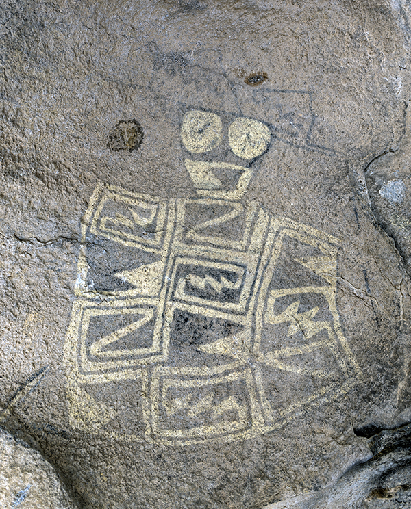
Three Rivers Petroglyph Site, Mogollon (Jornada), c. 900–1400, New Mexico(photo: jaygannett, CC BY-SA 2.0)
Petroglyphs and rock paintings
The Mogollon peoples also produced a great deal of rock art, such as at Three Rivers Petroglyph site where there are more than 20,000 petroglyphs made between 900–1400. While to visitors today many such sites might seem remote and isolated, these petroglyphs were part of a dynamic landscape, one that would been dotted with pithouses, many of which have since returned to the earth. Besides carving into living rock, Mogollon people also painted on them.
Rock drawings, or pictographs, in a restricted area of Hueco Tanks State Historic Site near El Paso in El Paso County, Texas, photograph by Carol M. Highsmith (Library of Congress, Prints and Photographs Division
At Hueco Tanks, sacred for the Jornada branch most likely, we find pictographs and paintings that adorn the walls of caves, such as birds, humans, and what are identified as masks. Many of the figures have been compared to Mesoamerican deities such as Quetzalcoatl and Tlaloc because they seem to have goggle eyes or feathered/horned serpents; as was discussed above though, figures like horned serpents were important to peoples across the Greater Southwest.
Multiple descendant groups still consider Hueco Tanks a sacred place; it is one of many footprints in the region that connect contemporary communities with their ancestors. The rock art also testifies to the important and long-standing relationship to place among Native communities in the region. Some of this stunning visual record is at risk, whether from vandalism, areas targeted for development, erosion, or industrial pollution.
A dynamic tradition
The Mogollon tradition was both diverse, expansive, and vibrant. Some of it has been destroyed or is at risk of destruction, threatening to partially erase some of the inventive and original architectural and artistic traditions are ancestral footprints and sacred nodes for multiple Native communities today.
Notes:
[1] Janet Catherine Berlo and Ruth B. Phillips, Native North American Art (Oxford: Oxford University Press, 2015), p. 56
[2] Albert Ernest Jenks, “Geometric designs on Mimbres bowls,” Art and Archaeology 33, no. 3 (1932): p. 137
[3] Stephen H. Lekson, “Mimbres art and archaeology,” in Archaeology, Art, and Anthropology: Papers in Honor of J.J. Brody, edited by M. S. Duran and D. T. Kirkpatrick. Papers of the Archaeological Society of New Mexico, vol. 18. (Archaeological Society of New Mexico, Albuquerque, 1992), p. 214
[4] Berlo and Phillips, Native North American Art, p. 54
[5] See Gaylord Torrance, et al., Art of Native America: The Charles and Valerie Diker Collection (New York: The Metropolitan Museum of Art, 2018).
Paquimé played a key role in trade and cultural contacts between the Pueblo culture of the southwestern United States and Mesoamerica.
Paquimé, Casas Grandes, which reached its apogee in the 14th and 15th centuries, played a key role in trade and cultural contacts between the Pueblo culture of the south-western United States and northern Mexico and Mesoamerica. The extensive remains, only part of which have been excavated, are clear evidence of the vitality of a culture which was perfectly adapted to its physical and economic environment, but which suddenly vanished at the time of the Spanish Conquest.
by Dr. David W. Penney, National Museum of the American Indian, Smithsonian Institution and Dr. Beth Harris
Found marking the grave of an important individual, this gorget was worn as a neck ornament during life.
Gorget, c. 1250–1350, probably Middle Mississippian Tradition, whelk shell, 10 x 2 cm (National Museum of the American Indian, Smithsonian Institution, 18/853), a Seeing America video. Speakers: Dr. David Penney, Associate Director for Museum Scholarship, Exhibitions, and Public Engagement, National Museum of the American Indian and Dr. Beth Harris
Source: Dr. David W. Penney, National Museum of the American Indian, Smithsonian Institution and Dr. Beth Harris, “Mississippian shell neck ornament (gorget),” in Smarthistory, January 13, 2018, accessed August 20, 2024, https://smarthistory.org/mississippian-gorget/.
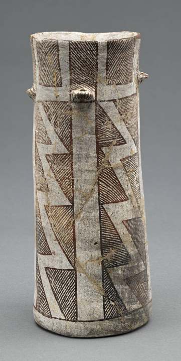
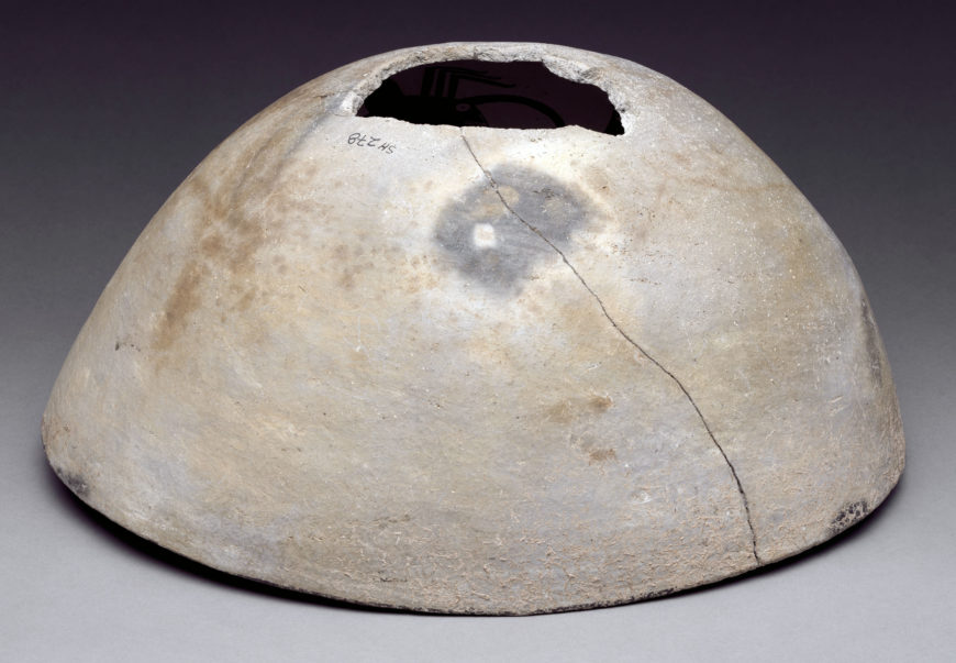
Ancestral Pueblo, Socorro black and white storage jar
This Ancestral Puebloan jar was made to store goods during a time of drought.
Ancestral Pueblo, Socorro black-on-white storage jar, c. 1050–1100, clay and pigment, made in New Mexico, United States, 38.1 x 43.2 cm (The Metropolitan Museum of Art, New York). Speaker: Brian Vallo, Director, Indian Arts Research Center School for Advanced Research, Santa Fe, New Mexico