American history starts 15,000 years ago with the first people in the Americas. These societies were diverse, adapting to their environments. Key developments included the domestication of corn around 5000 BCE and the formation of complex societies. By the time Europeans arrived, there were about 50 million people in the Americas.
About geography and chronological periods in Native American art
by Dr. Lauren Kilroy-Ewbank
Typically when people discuss Native American art they are referring to peoples in what is today the United States and Canada. You might sometimes see this referred to as Native North American art, even though Mexico, the Caribbean, and those countries in Central America are typically not included. These areas are commonly included in the arts of Mesoamerica (or Middle America), even though these countries are technically part of North America.
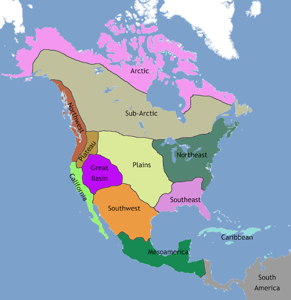
So how do we consider so many groups and of such diverse natures? We tend to treat them geographically: Eastern Woodlands (sometime divided between North and Southeast), Southwest and West (or California), Plains and Great Basin, and Northwest Coast and North (Sub-Arctic and Arctic). While this is by no means a perfect way of addressing the varied tribes and First Nations within these areas, such a map can help to reveal patterns and similarities.
Map of North America showing the regions of Native American cultures
Chronology
Chronology (the arrangement of events into specific time periods in order of occurrence) is tricky when discussing Native American or First Nations art. Each geographic region is assigned different names to mark time, which can be confusing to anyone learning about the images, objects, and architecture of these areas for the first time. For instance, for the ancient Eastern Woodlands, you might read about the Late Archaic (c. 3000–1000 B.C.E.), Woodland (c. 1100 BCE–1000 C.E.), Mississippian (c. 900–c. 1500/1600 C.E.), and Fort Ancient (c. 1000–1700) periods. But if we turn to the Southwest, there are alternative terms like Basketmaker (c. 100 B.C.E.–700 C.E.) and Pueblo (700–1400 C.E.). You might also see terms like pre- and post-Contact (before and after contact with Europeans and Euro-Americans) and Reservation Era (late nineteenth century) that are used to separate different moments in time. Some of these terms speak to the colonial legacy of Native peoples because they separate time based on interactions with foreigners. Other terms like Prehistory have fallen out of favor and are problematic since they suggest that Native peoples didn’t have a history prior to European contact.
Organization
We arrange Native American and First Nations material prior to circa 1600 in “North America: later cultures before European colonization”, which includes material about the Ancestral Puebloans, Moundbuilders, and Mississippian peoples. Those objects and buildings created after 1600 are in their own section, which will hopefully highlight the continuing diversity of Native groups as well as the transformations (sometimes violent ones) occurring throughout parts of North America. Artists working after 1914 (or the beginning of WWI) are not located in the Art of the Americas section, but rather in the modern and contemporary areas.
Additional resources:
Janet Catherine Berlo and Ruth B. Phillips, Native North American Art, 2nd ed. (Oxford: Oxford University Press, 2015).
Brian M. Fagan, Ancient North America: The Archaeology of a Continent, 4th ed. (London: Thames and Hudson, 2005).
David W. Penney, North American Indian Art ( New York: Thames and Hudson, 2004).
Karen Kramer Russell, ed., Shapeshifting: Transformations in Native American Art (New Haven: Yale University Press, 2012).
The earliest complex societies in North America began to emerge in the Ohio River valley around 1000 BCE, at the start of the Formative period, when mound-building cultures with large populations in the Eastern Woodlands became more common.
Mound-Building Cultures in the Eastern Woodlands
The mound-building culture of the Ohio River valley area is often referred to as the Adena, after a mound excavated in 1901 in Ross County, Ohio. This and the hundreds of others discovered in the area were burial sites. They started small, with the burial of one or two important people, but grew over time as more were buried and more earth was used to cover them. Some of the mounds had a large circular ditch surrounding them and logs lining the interior. Evidence of postholes indicates that structures once stood there as well, suggesting the locations may have been meeting or ceremonial spots. The bodies of the dead themselves were often decorated with red ocher and other pigments. Grave objects included jewelry, weapons, stone tools, marine shells, and pipes for smoking kinnikinnick (a mixture of leaves and bark) and perhaps tobacco.
Owl Pipe of the Adena Culture. Carefully carved pipes like this one dating from 900–1300 CE could be buried with their owners in the mounds built by the ancient Adena culture in the Ohio River valley. (credit: “Owl effigy pipe” by “Wmpearl”/Wikimedia Commons, CC0 1.0)
Communities of mound builders in the valley remained small at first, sometimes erecting no more than a couple of structures. The mounds themselves were also relatively small when compared with those of later cultures like the Hopewell tradition, a civilization that emerged around 200 BCE and eventually spread across the Eastern Woodlands through a common network of trade routes. Named for a large earthwork complex occupying 130 acres in today’s Ohio, the Hopewell tradition emerged around 200 BCE and is one of the most impressive of many of this period in the Woodlands. The site encloses thirty-eight different mounds within a large earthen D-shaped rectangle. The largest are three conjoined mounds; before centuries of erosion occurred, together they measured about five hundred feet wide and thirty feet high. Large platforms once supported wooden structures and were likely used for ritual purposes.
Another Hopewell site located near Newark, Ohio, is equally impressive, with earthen enclosures, mounds, and an observation circle all organized to align with the movement of the moon and likely used to predict lunar eclipses and other seasonal events. Building such mounds with the available technology would have been a labor-intensive task and indicates the culture responsible was highly organized.
The mound complexes were used for ceremonial purposes and do not appear to have been the site of urban settlements. Instead, most people of the Hopewell culture lived in small dispersed communities consisting of only a few extended families. They employed both hunter-gatherer strategies and the cultivation of domesticated plants like sunflowers and bottle gourds. Neighboring groups likely came together to participate in hunting, gathering, and religious events at their ceremonial sites. Religious traditions included the veneration of ancestors, such as those buried in the mounds.
Different communities from the wider area buried their dead leaders in the same mounds, likely as a way to establish symbolic connections across kin groups. Evidence from sites like the one at Newark suggests that ceremonies for burial and veneration were probably connected to seasonal changes and important astronomical observations. The items deposited in the mounds included a number of artistic depictions of animals like beavers, bears, dogs, cats, and even supernatural mixtures of these. These likely had symbolic importance for the individual kin groups and were connected to both their religious practices and specific ancestral ceremonies.
Politically, the settlements of the Hopewell tradition were decentralized and mostly egalitarian. The leadership structure of individual kin groups may have revolved around shamans or shamanistic practices, but there were no powerful rulers. There were, however, some divisions of labor based on specialization, including healers, clan leaders, and those who possessed certain spiritual qualities necessary for interpreting astronomical signs, preparing burials, and preserving important religious traditions. Ceremonial objects made of copper, bone, stone, and wood and shaped into bird claws and totem animals aided shamanistic figures in their duties and were often buried with them. Items within the mounds also provide evidence of extensive long-distance trading. Those discovered in the Ohio River valley include copper from Lake Superior, quartz from Arkansas, mica from the Appalachian region, marine shells from the Gulf coast, and obsidian from as far away as the Rocky Mountains. Trade in these objects was carried out by individuals moving along rivers or the networks of village paths.
Turtle Island
The earthen mounds of the Eastern Woodlands region had a number of symbolic meanings and purposes. They served as burial sites, provided connections to ancestors, and were settings for religious rituals. But what do ancient stories suggest about these mounds? Because the Native Americans who built them did not leave behind written records, their legends are one tool modern scholars can use to understand their symbolic importance.
Consider one of the ancient origin stories common to many Indigenous groups of the Eastern Woodlands. Preserved orally in numerous versions, it tells of the construction of the world by the accumulation of earth upon the shell of a large turtle, which grew over time and supported life. Some versions of the story begin with a great flood, after which animals work diligently to bring up earth from below the water to place on the turtle’s back. Other versions refer to a woman with supernatural powers who falls or travels from the heavens and creates the world on a turtle’s back. Across all the versions, the symbolic importance of the turtle, representing life, is paramount.
Sky Woman. In some versions of the Turtle Island story, a woman descends from the heavens to create the world on the back of a turtle. This 1936 oil painting called Sky Woman by the twentieth-century Seneca artist Ernest Smith illustrates such a moment. (credit: “’Sky Woman”, by Ernest Smith. 1936” by Unknown/Wikimedia Commons, Public Domain)
While we cannot know for sure, the Woodlands mounds may have been connected to this ancient origin story. They certainly would have provided safety from river flooding in low-lying areas. During such times, the connection between the mound and the turtle floating in the water would have been difficult to miss.
What purpose do you think origin stories like these served for the ancient people of the Eastern Woodlands?
Do you think using preserved origin stories is a good way to understand ancient peoples and customs? Why or why not?
The Hopewell tradition settlements began to decline in the fourth century CE, evidenced by a waning of mound building and trade. The precise reason is not clear, but larger kin group alliances may have broken down as a result of underlying religious issues. Beginning around 600, groups in the Midwest built a number of so-called effigy mounds. These are earthen mounds formed in the image of animals like wolves, bears, snakes, and birds. Like many earlier mounds, the effigy mounds were also burial sites, but they usually contained only a few individuals. In comparison to the earlier Hopewell mounds, they were generally constructed with less labor and in a shorter amount of time, possibly by just a few dozen people working for a few days.
Early Cultures of the American Southwest
Far to the west of the mound-building cultures, a very different cultural tradition formed in the arid landscape of the Southwest. Here, people began experimenting with maize varieties as early as the third millennium BCE. By that time, some groups in the region had begun planting maize in small plots along riverbanks and using it to supplement their hunter-gatherer existence. Exactly how maize reached the American Southwest from southern Mexico is not clear, but there must have been some sporadic contact between cultivators in the south and hunter-gatherer adopters farther north. However, for many centuries after maize was introduced into the Southwest, its cultivation remained limited to one small part of a lifestyle firmly rooted in hunting and gathering. It is possible that the arid conditions of the region necessitated greater mobility and thus made the advantages of maize cultivation less obvious.
Some of the earliest evidence of maize cultivation in the area dates from about 2250 BCE and comes from what is now northwestern New Mexico. By around 1200 BCE, groups in the Las Capas area, by the Santa Cruz River near modern Tucson, Arizona, had developed a sophisticated irrigation system for cultivating maize. The people at Las Capas built a network of canals that directed water from the river into their fields. Around this agricultural base, they constructed oval-shaped homes and pits for roasting the maize they grew. Over time, the homes became more elaborate and were organized in rings around courtyards. But even here the cultivation of maize remained only a small part of a largely hunter-gatherer lifestyle, which included gathering goosefoot and piñons as well as hunting rabbits, bison, and deer.
By around 500 BCE, the cultivation of beans was adding to the growing diversity of foods consumed in the Southwest. This change helped to encourage more dependence on maize since, nutritionally speaking, these two foods are complementary—beans are a source of lysine, a necessary amino acid that maize lacks. Growing beans with maize also increases the nitrogen in the soil and preserves its fertility for longer periods. However, even after the introduction of beans, settled and solidly agricultural communities in the Southwest did not begin to emerge until around 200 CE. Once they did, the region entered a transformational period that resulted in the development of the Anasazi or Ancestral Pueblo societies.
Adapted from Ann Kordas, Ryan J. Lynch, Brooke Nelson and Julie Tatlock, World History, Vol. 1, to 1500, Houston, OpenStax, 2023 (https://openstax.org/books/world-history-volume-1/pages/1-introduction). CC By 4.0 Deed
RELIGION and PHILOSOPHY
Coyote and Raven
Mike Rugnetta continues to teach you about Tricksters in myth, and this time we’re headed to the Americas. Coyote and Raven appear in stories from many Native American groups, and more often than not, they’re tricky. They’re also often kind of, well, nasty. Not to get too judgy. But we do a lot of talking about poop in this episode. I’m just saying. We also talk about Tricksters as creators, as Coyote creates constellations, and Raven creates some rivers.
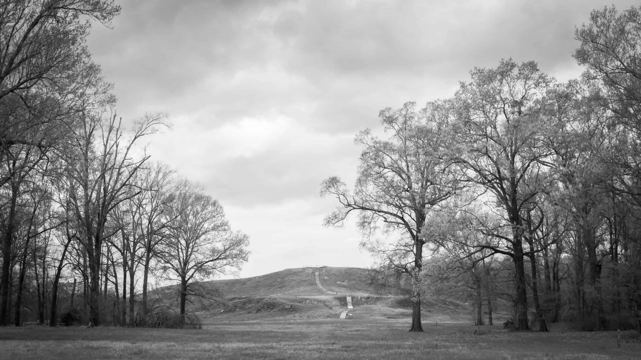
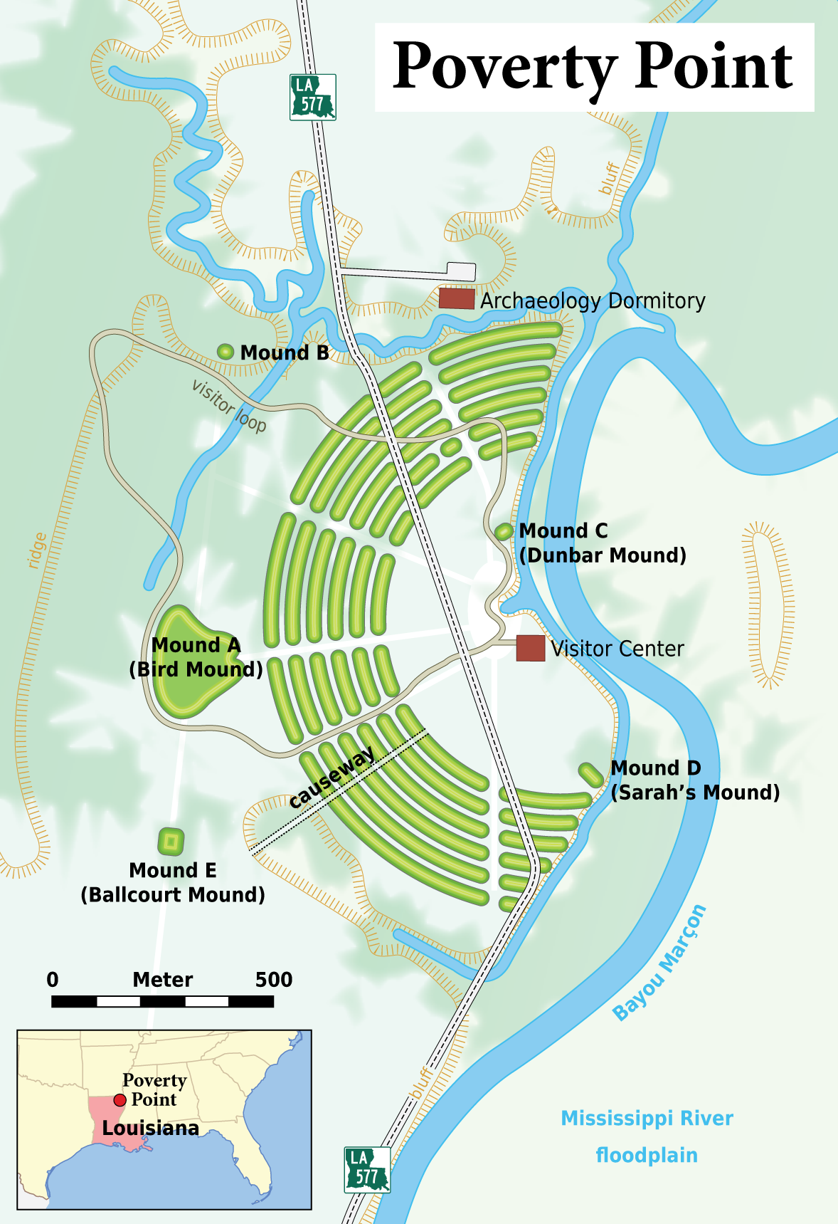
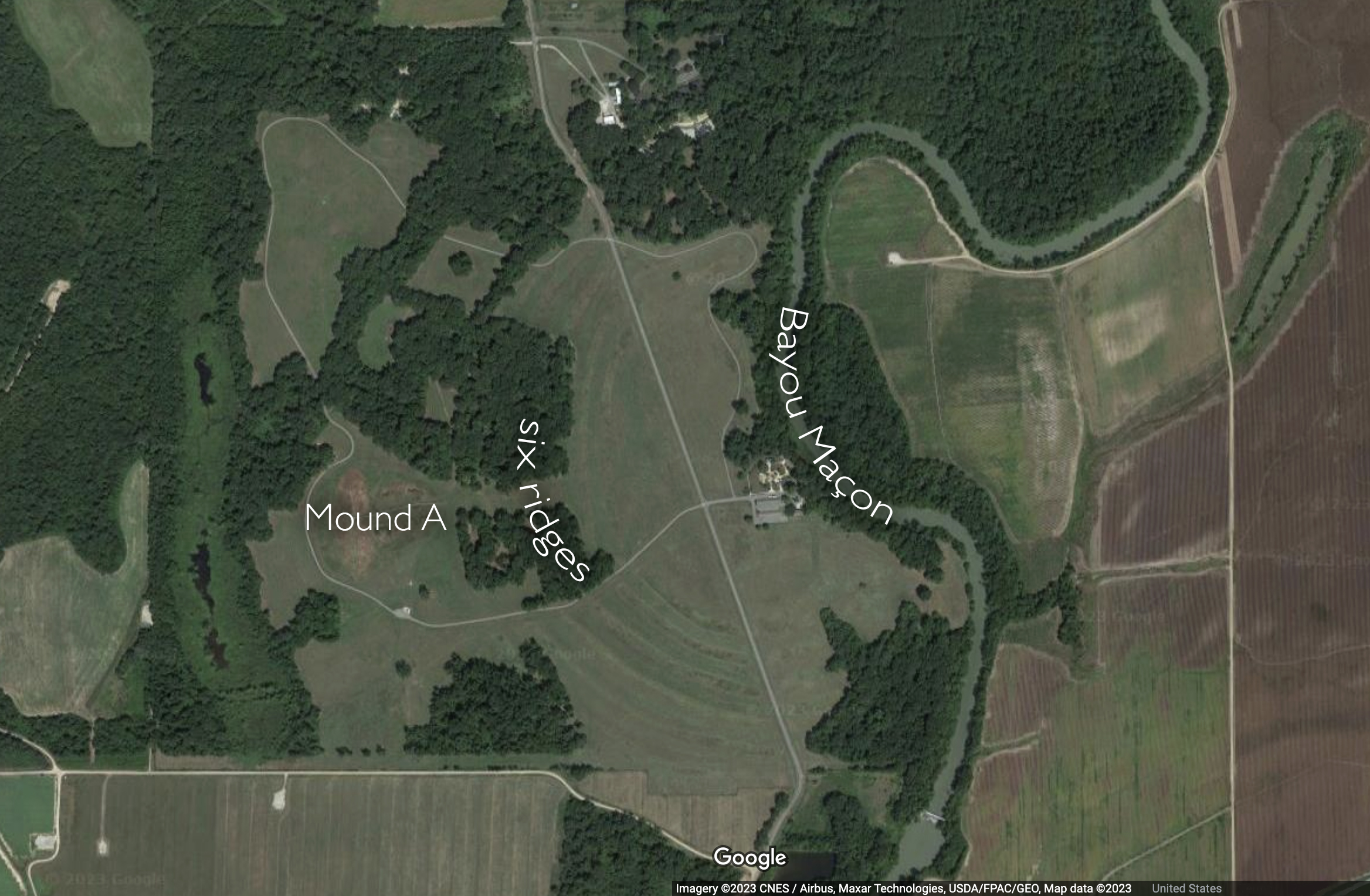
Mound A, Poverty Point, Louisiana, c. 1300 B.C.E., earthwork, 710 feet long x 660 feet wide x 72 feet high (photo: courtesy of Jenny Ellerbe, 2012)Plan of Poverty Point
An ancient Indigenous city, 1650–800 B.C.E.
In the Lower Mississippi Valley in Louisiana, an ancient Indigenous city called Poverty Point flourished between 1650–800 B.C.E. in the Late Archaic Period. [1] The people who traveled through and settled here built several monumental earthworks including Mound A, which is a massive structure, and six curved concentric earthen ridges. The Archaic Period people of the city gathered and moved over one million cubic meters of soil to create this lived-in environment. Spread out over seven square kilometers and never faced in stone, these structures and other public works blend into the land out of which they were built. During the Mid-Archaic period, between 3500 and 2800 B.C.E., Indigenous architects and engineers designed and built with their communities the earliest earthworks in Louisiana at Watson Brake. Various settled and nomadic communities would continue to build or maintain earthworks as burial sites or meeting places into and beyond the 18th century. Outside of Columbus, Ohio contemporary Indigenous communities have successfully advocated for several ancient earthworks to be protected as World Heritage Sites along with Poverty Point. In 2022, the large magnificent earthworks at Newark, Ohio were granted this protection, and one of the largest of these earthworks, on land currently leased to a golf course, will be returned to the state of Ohio for protection as a sacred Native American monument.
In the 19th century, Mound B and Mound C were recognized as ancient monuments. Mound A, the second-largest ancient architectural structure north of Mexico, was so large and appeared to be so thoroughly integrated into the contours of the land, that as late as 1926 archaeologists believed it was a natural feature of the landscape.
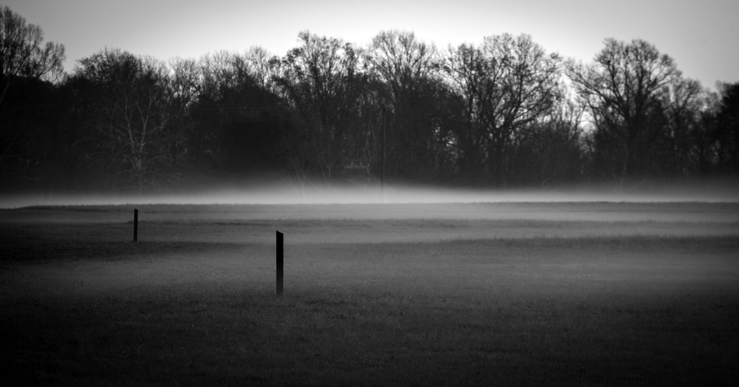
Ridges, Poverty Point, Louisiana, c. 1500 B.C.E. (photo: courtesy of Jenny Ellerbe, 2012)
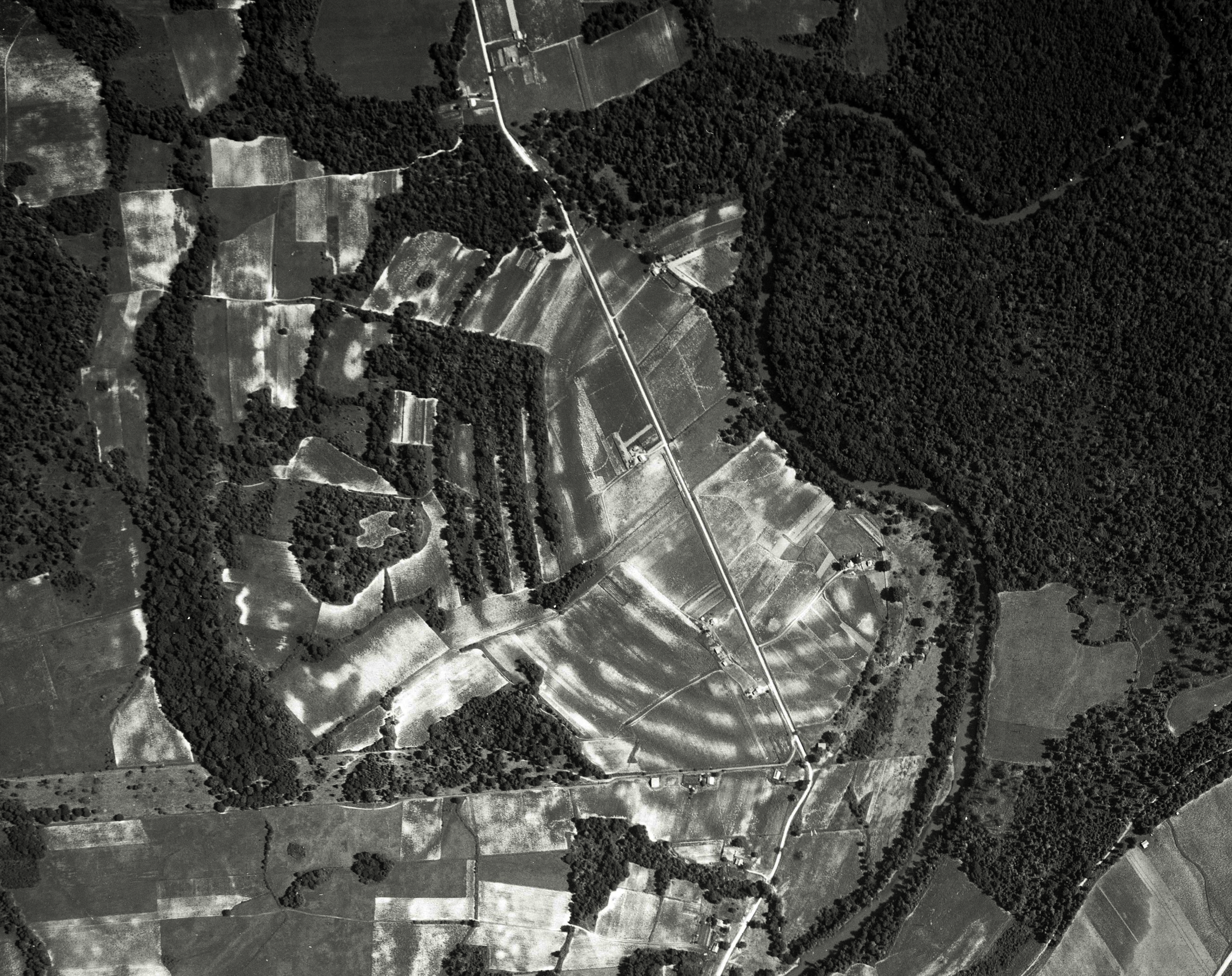
The sculpted concentric ridges that are unique to Poverty Point are low to the ground and spread out over a mile in length. Today they are worn down by time and use of the land, but still vaguely visible in raking light between the mist and the built-up ridges. Neither colonists nor archaeologists recognized these ridges as built monumental structures until the summer of 1953, when archaeologist James Ford happened to look at Army Corps aerial photographs of the region that revealed their distinct manmade composition.
Aerial photograph of the six ridges at Poverty Point, Louisiana, c. 1500 B.C.E., six semicircular earthworks, originally six feet high and three-quarters of a mile long (photo: Edgar Tobin Aerial Surveys, courtesy of P2 Energy Solutions, Tobin Aerial Archive, 1938)
The site’s history
Groups of hunter-gatherers first settled at Poverty Point in 1650 B.C.E. They would live here continuously for the next five hundred years, creating one of the most unusual cities of the ancient world: a densely populated, extensively developed settlement that lasted for five centuries without evidence of large-scale agriculture and with no evidence of an elite class. Said more plainly, this was an egalitarian hunter-gatherer community with a long-distance trade network that collectively and demonstrably shaped the land where its inhabitants lived. Amongst the most important imported objects that we find by the hundreds at Poverty Point are any kind of stone tool or ornament—from chert spear points to granite celts and slate bannerstones. Since no stone of any kind is local to this part of the lower Mississippi due to the force of the river that carved bayous into the land and would have worn away all lithic material well before it could travel into the region, all stone would have been brought into the city through trade. At its height, Poverty Point is estimated to have had a population of 9,000, a significant portion of which lived there year-round, with a varying influx of people who valued and contributed to the site’s construction and maintenance. They built these monuments within the rich alluvial floodplain of the lower Mississippi overlooking the meandering Bayou Maçon, a constant reliable source of freshwater, fish, and waterway transportation.
The earliest monuments built at Poverty Point were a flat-top pyramid and then two conical earthworks. Later, the inhabitants conceived and constructed the six concentric arched ridges, each originally six feet in height and three quarters of a mile long. They constructed these arched ridges as platforms where they placed hearths for cooking, leaving thousands of objects of daily life in surrounding middens. As a monumental public work, these arches are unique to the region; indeed, they are unique to all of North America.
The arched shape ridges radiate out from the narrow bottom edge of Mound A into what may have been used as a plaza-like space, leading scholars to speculate on whether Poverty Point may have been a pilgrimage site specifically structured to welcome large influxes of temporary inhabitants and visitors. The arrangement of the arches in evenly spaced rows align with the arc of the facing bayou, revealing the desire of the builders to actively engage with the topography of the land. To repeat the arc of the bayou in the shape of their manmade ridges visually and experientially established an ongoing conversation with the myriad bodies of water connected to the nearby Mississippi River. Compositionally, these six ridges were an extraordinary monumental public work collectively built that integrate the living presence of this ancient community within the landscape. This was not a wall to keep people out, but rather a set of arched ridges that linked a particular community to a particular landscape.
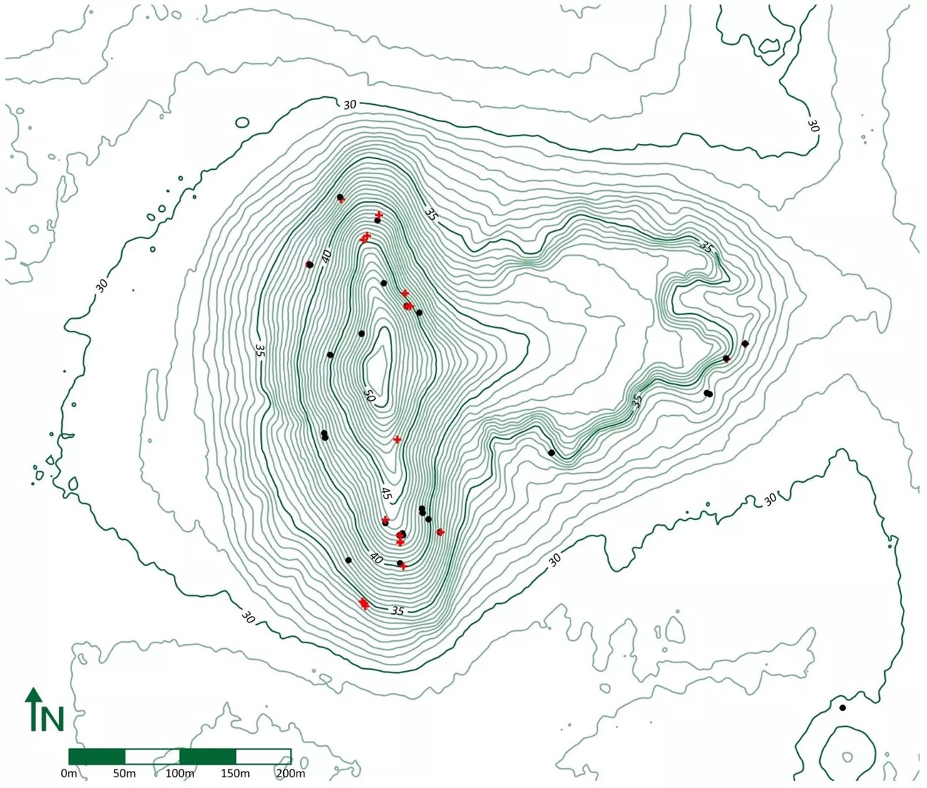
Topographical map of Mound A (photo: Diana Greenlee, University of Louisiana at Monroe)
Mound A
Around 1300 B.C.E., 350 years after they began building at the site, the people of Poverty Point built their last and largest monument, now known as Mound A. Carefully placed in the center behind the arched ridges, Mound A is seventy-two feet high, 710 feet long, and 660 feet wide. At its widest it appears like a set of outstretched wings, narrowing to a point, like the beak of a bird flying west over the manmade arched ridges. It is a solid earthen structure that was built in three discernible stages. To build each stage from the base elevation up, they purposefully used three distinct kinds of soil. These soils are different in color and composition and may have been gathered and used at each stage for conceptual or structural purposes. The careful arrangement of these soils further reveals the highly organized and conscious nature of this construction. Since there was no evidence of weathering between the stages, they must have built this structure rapidly, perhaps in as little as three months, moving over fifteen million baskets of dirt to the site. There is also no evidence that they built any structure on top of Mound A or buried any individual inside. It stands as a monumental work made by and for those who chose to live here.
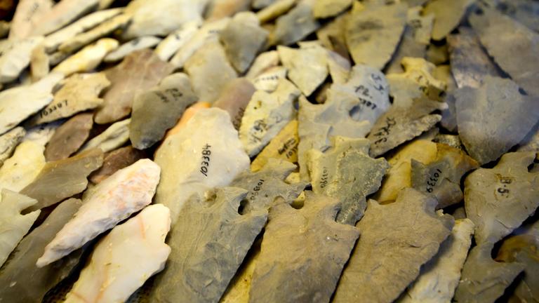
Stone spear tips found at Poverty Point (photo: Poverty Point World Heritage Site)
The egalitarian nature of life and the meaning or purpose of art at Poverty Point can also be seen in the even distribution of stones. 200 bowls carved out of soapstone imported from outcrops in Alabama and Tennessee were intentionally broken and ritually buried on the western periphery of the site, a location behind Mound A where the sun would set each day, suggesting an astronomical alignment. Imported stones found at the site were not the exclusive property of elites like we find at other ancient sites like Cahokia in Illinois or La Venta in Mexico; here at Poverty Point they are found in public spaces or evenly spread beneath the concentric ridges, along with baked clay forms for cooking.
An ancient society
When looked at closely and in comparison with other known ancient societies of the 1st and 2nd millennia B.C.E., such as the Olmec of Central Mexico, Poverty Point defies norms and expectations that link monumentality with elite patronage. At Poverty Point, people formed a settled society without agriculture. They built monumental architecture and earthworks without vast hierarchical divisions.
Given the importance of water for settled life in the ancient world, the settlement of Poverty Point begins with what is most conspicuously already there, that is, the Bayou Maçon itself. Together, the bayou and and natural elevation of its shoreline provided prolonged safe access to fresh water without the risk of flooding so common in the alluvial Mississippi Valley. The low, long, and arched ridges that the people of Poverty Point built are both large and inconspicuous at the same time. They are semicircular embankments built to complement daily life where people built their hearths and lived side by side. Conversely, Mound A slopes up symmetrically from behind the arched ridges into a mountainous earthen monument. On top of Mound A, the Archaic Indigenous people who lived here created for themselves an exceptional vantage point from which to look out over the arched ridges, to experience them as a visual echo of their immediate source of water. In this striking composition, manmade monuments were orchestrated to visually complement the natural contours of the land and its resources that supported them.
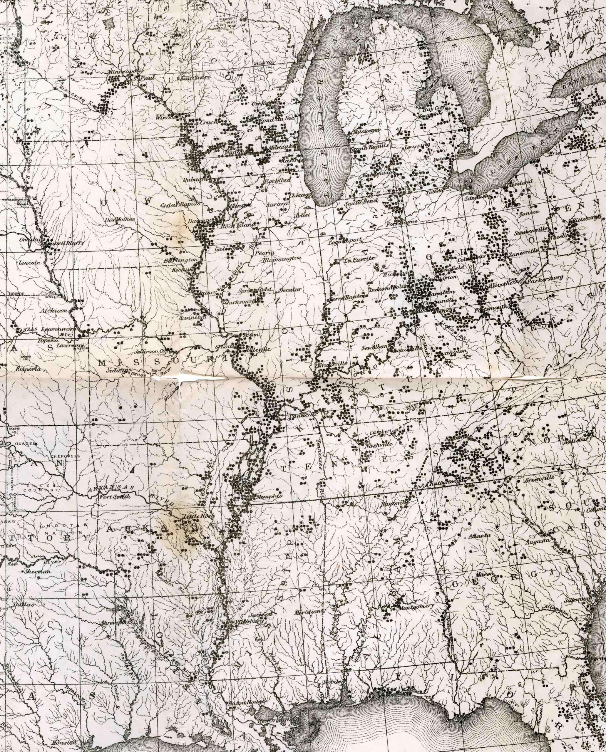
Map of Indigenous ancient architectural monuments (detail), Cyrus Thomas, “Distribution of Mounds in the Eastern United States,” Catalogue of Prehistoric Works East of the Rocky Mountains (Washington, D.C.: Smithsonian Institution, 1891, plate 1)
The abandonment of the site
Approximately 150 years after the completion of Mound A, sometime between 1000 and 800 B.C.E., the people of Poverty Point abandoned the site. This occurred in a transitional period between the Late Archaic and Early Woodland Periods marked by radically increased periods of rain. And though there is no evidence that flooding occurred at Poverty Point, the rain would nevertheless have disrupted the influx of seasonal inhabitants and long-distance trade so important to the formation and maintenance of the city. Looking at Cyrus Thomas’ 1891 map of Indigenous ancient architectural monuments we can begin to see and imagine Poverty Point as one of thousands of places within the Mississippi and Ohio River Valleys where Native Americans made their homes and shaped the land.Notes:
[1] The very name “Poverty Point” tells us something of the site’s obscure modern history. In 1851 Philip Guier developed it into one of his southernmost plantations. Whereas plantations in the Middle Mississippi Valley, in states such as Tennessee or Kentucky, often had luscious names like Tulip Hill or His Lordship’s Kindness, those in the Lower Mississippi Valley, which were less reliable in the production of cotton, were often given pejorative names like Poverty Point or Hard Times Plantation. And while the archaeological site is currently a U.S. National Monument and a UNESCO World Heritage Site, recognized for its ancient monumental architecture, it is still known by a name that marks it as a low-yield pre-Civil War plantation.
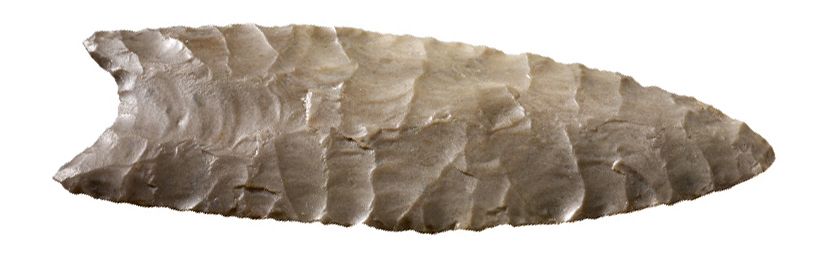
The first clear evidence of human activity in North America are spear heads like this. They are called Clovis points. These spear tips were used to hunt large game. The period of the Clovis people coincides with the extinction of mammoths, giant sloth, camels and giant bison in North America. The extinction of these animals was caused by a combination of human hunting and climate change.
North America was one of the last continents in the world to be settled by humans after about 15,000 BC. During the last Ice Age, water, which previously flowed off the land into the sea, was frozen up in vast ice sheets and glaciers so sea levels dropped. This exposed a land bridge that enabled humans to migrate through Siberia to Alaska. These early Americans were highly adaptable and Clovis points have been found throughout North America. It is remarkable that over such a vast area, the distinctive characteristics of the points hardly vary.
Typical Clovis points, like the example above, have parallel to slightly convex edges which narrow to a point. This shape is produced by chipping small, parallel flakes off both sides of a stone blade. Following this, the point is thinned on both sides by the removal of flakes which leave a central groove or “flute.” These flutes are the principal feature of Clovis or “fluted” points. They originate from the base which then has a concave outline and end about one-third along the length. The grooves produced by the removal of the flutes allow the point to be fitted to a wooden shaft of a spear.
The people who made Clovis points spread out across America looking for food and did not stay anywhere for long, although they did return to places where resources were plentiful.
Clovis points are sometimes found with the bones of mammoths, mastodons, sloth and giant bison. As the climate changed at the end of the last Ice Age, the habitats on which these animals depended started to disappear. Their extinction was inevitable but Clovis hunting on dwindling numbers probably contributed to their disappearance.
Although there are arguments in favor of pre-Clovis migrations to America, it is the “Paleo-Indian” Clovis people who can be most certainly identified as the probable ancestors of later Native North American peoples and cultures.
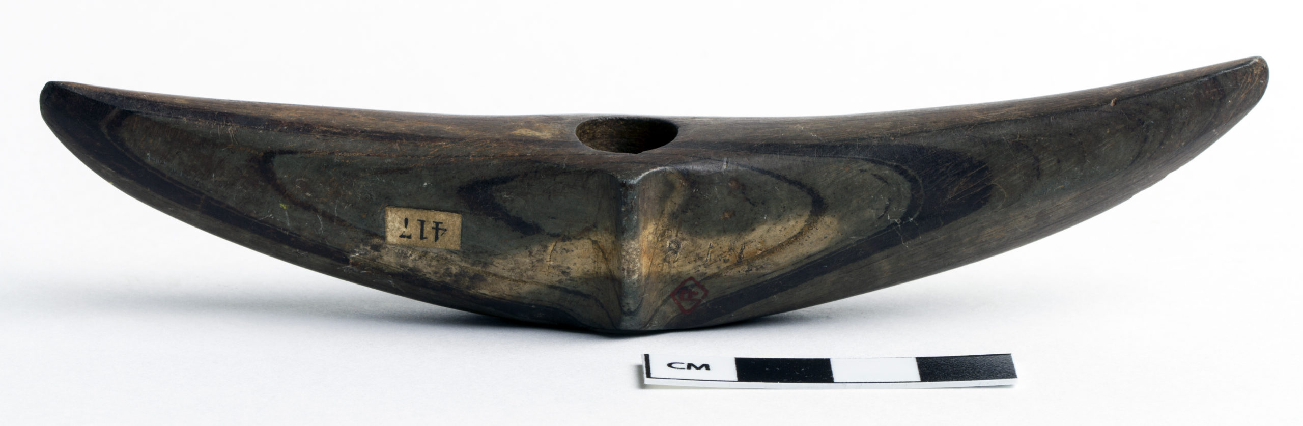
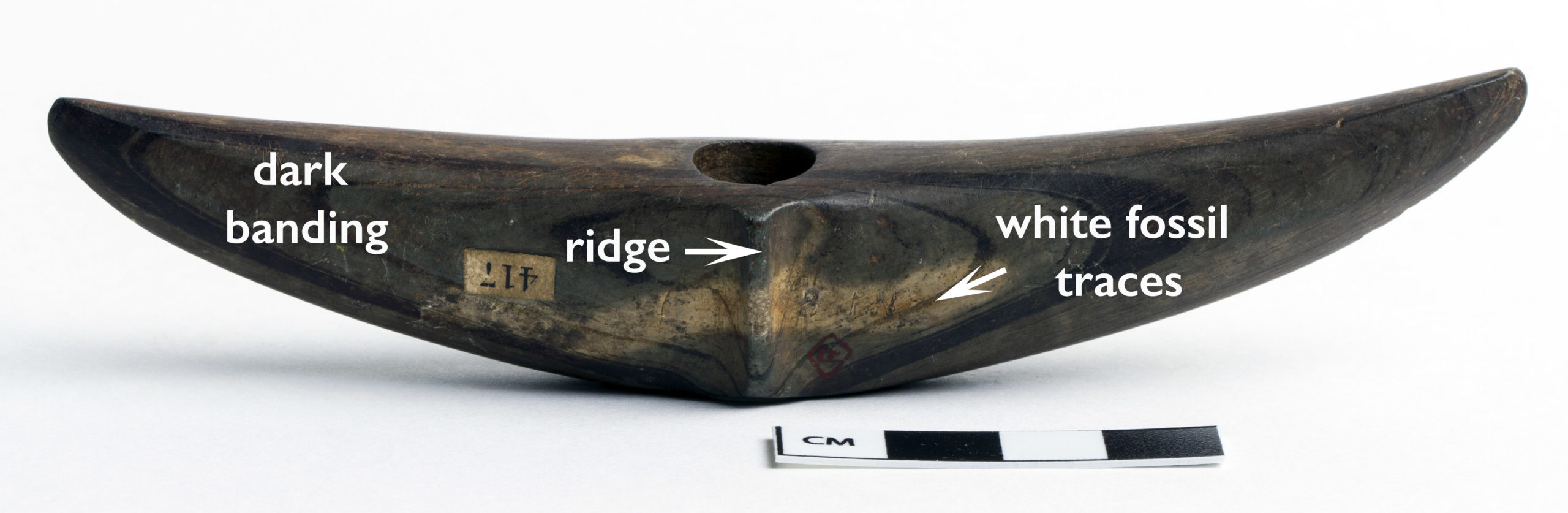
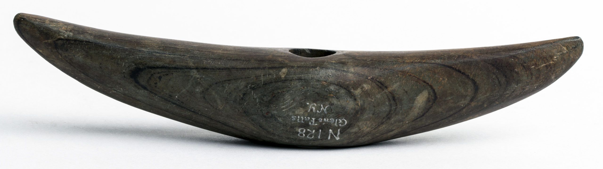
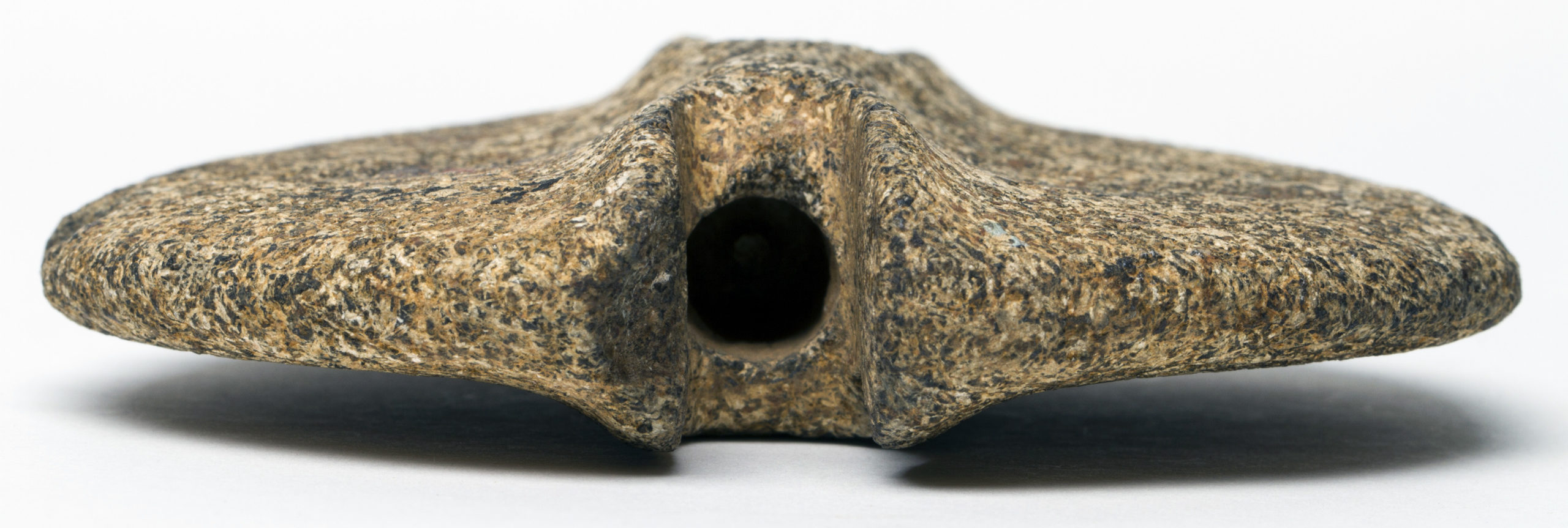
Curved Pick Bannerstone, Glenn Falls, New York, 6,000–1,000 B.C.E., banded slate, 2.7 x 13.6 cm (American Museum of Natural History DN/128)
Why is it that in schools across the United States we learn about the ancient Egyptians and Greeks and Chinese, but not about the ancient people of North America? In the Eastern half of the United States between 6000 and 1000 B.C.E., in a period known as the Archaic, thousands of nomadic Native Americans travelled and lived along the Mississippi and Ohio rivers. Amongst the art they made and left behind are enigmatic, carefully carved stones known today as bannerstones. They are generally symmetrical in shape and drilled down the center, leading 19th-century archaeologists and collectors to assume that these uniquely carved stones were placed on wooden rods hoisted in the air as “banners.” Today we are far less certain why they were made or how they were used, nonetheless we still call them bannerstones.
Curved Pick Bannerstone, Glenn Falls, New York, 6,000–1,000 B.C.E., banded slate, 2.7 x 13.6 cm (American Museum of Natural History DN/128)
Bannerstones, like the slate Curved Pick from Glenn Falls, New York, are carefully chosen stones that were then carved, drilled, and polished compositions. At the center of this particular stone, an Archaic sculptor carved a small ridge that marks and accentuates the off-white markings left by a worm or some other biologic element to form what is known as a trace fossil embedded into the sedimentation of the rock as it formed. The sculpted ridge and white fossil traces cross over and through the symmetrical dark natural banding of the slate (the slate was formed by two geologic processes, a sedimentation process and then a metamorphic process). Each different color of the banding from the light brown to the dark brown indicates a different layer of sedimentation hardened into the rock structure.
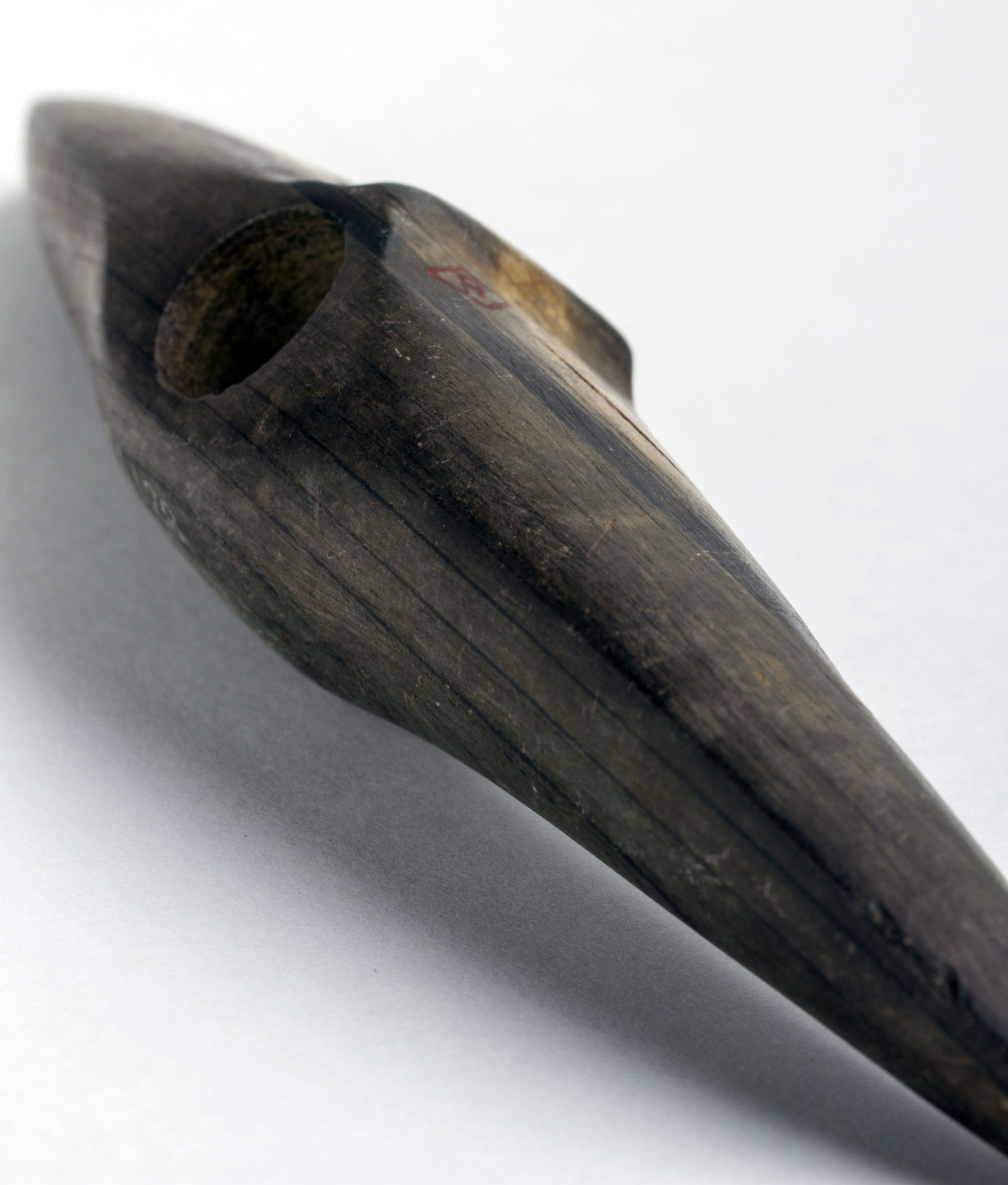
Curved Pick Bannerstone (reverse), Glenn Falls, New York, 6,000–1,000 B.C.E., banded slate, 2.7 x 13.6 cm (American Museum of Natural History DN/128)
On the other side, the banding of the stone forms a noticeably different pattern, making this a naturally occurring slate with different sedimentary patterns on either side of the stone that further attracted and challenged the sculptor to compose both sides into a single complex composition with the curved form of the sculpted bannerstone echoing and accentuating the concentric forms of the dark banding. Given that slate is a relatively soft stone and easier than other stones to shape and drill, it is one of the most common stones chosen by ancient Native North Americans for the making of bannerstones, especially in the Ohio Valley.
Curved Pick Bannerstone (top), Glenn Falls, New York, 6,000–1,000 B.C.E., banded slate, 2.7. x 13.6 cm (American Museum of Natural History DN/128)
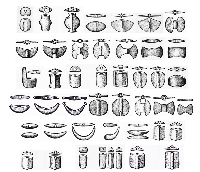
Once the raw stone was found river-worn or quarried from a mountainside, the sculptor would take a harder stone known as a “hammerstone” to begin to peck and then grind the banded-slate, modeling their work on one of twenty-four distinct bannerstone types modern-day scholars have defined in our studies of these ancient Native American artworks.
Twenty-four different types of bannerstones identified by Byron Knoblock in 1939
Choosing the Curved Pick type, one of several bannerstone forms particular to the Northeast, the sculptor worked their composition to be precisely centered on the two different faces of the banded slate, grinding the “wings” into a raised edge that runs through the dark slate bands, and flattening, shaping, and smoothing the surface around the perforation, further individualizing their finished work. The individuality of each bannerstone in relation to recognizable forms, recognizable to the Archaic sculptor and to those of us studying these stones today, is an intrinsic component of their making and meaning.
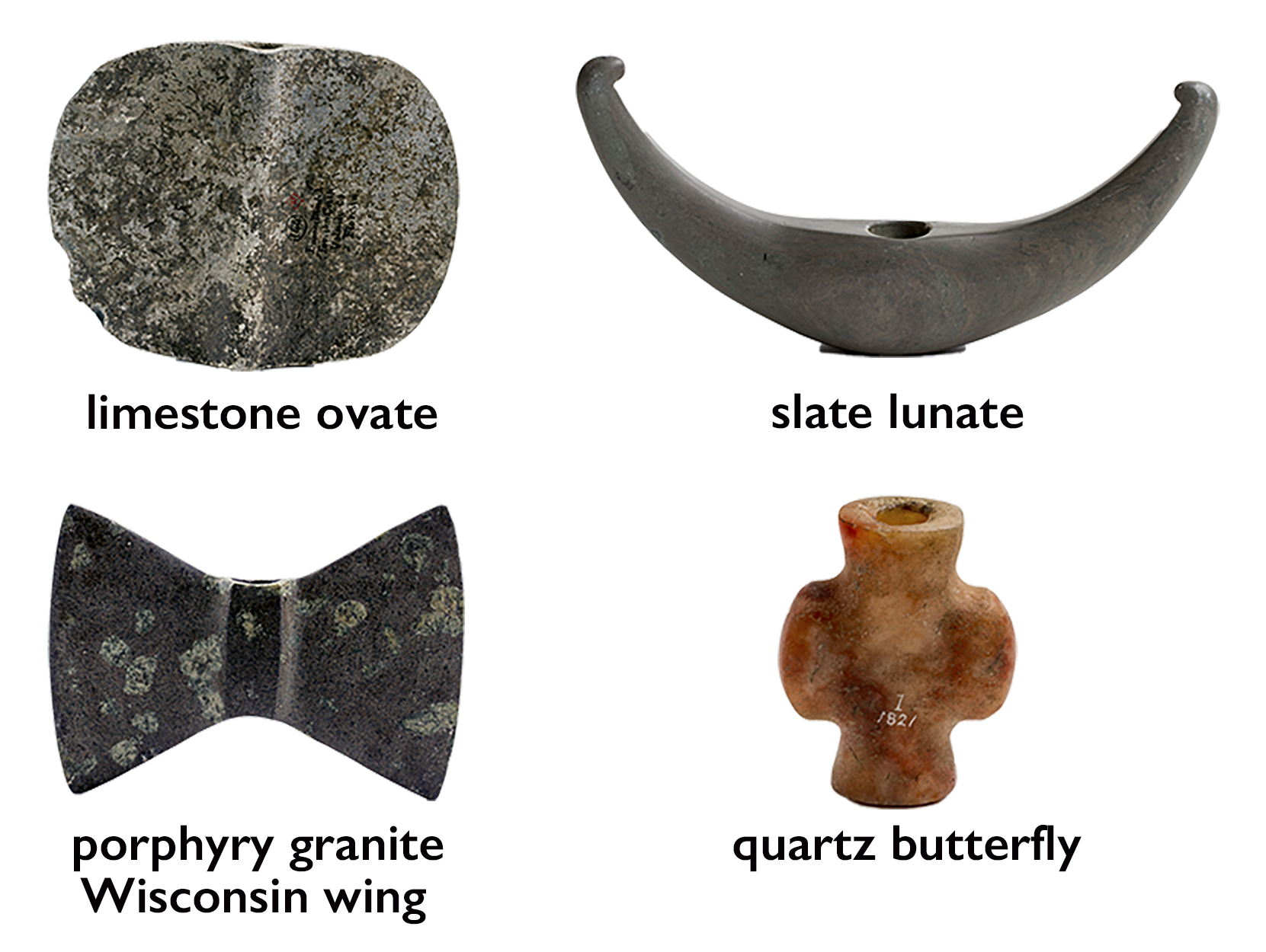
Different types of bannerstones (clockwise from left: American Museum of Natural History d/144 Limestone; American Museum of Natural History 13/105 Slate; NMNH A26077 Porphyry Granite; American Museum of Natural History 1/1821 Quartz)
Bannerstones were made from many types of stone including those that are sedimentary, metamorphic, and igneous. The sedimentary rock that we see in a limestone ovate bannerstone is the softest, while slate (a metamorphic stone) shows more signs of natural geologic transformation such as banding that we see in a lunate bannerstone. Igneous rock is the hardest and often has embedded elements from various minerals when magma first bubbled up from the core of the earth and cooled. This kind of complex igneous surface is evident in a porphyry granite Wisconsin wing bannerstone. Some bannerstone (like the quartz butterfly) are made out of even harder material made of minerals and crystals that would have been even more time consuming and challenging to carve. The relative hardness of the stone chosen by the sculptor would have an impact on the kinds of bannerstone forms they would or could sculpt. The thin wings of slate and even granite bannerstones could not be carved out of quartz, while the seemingly thick rounded form of a Quartz Butterfly bannerstone might appear unfinished if it were carved in slate.
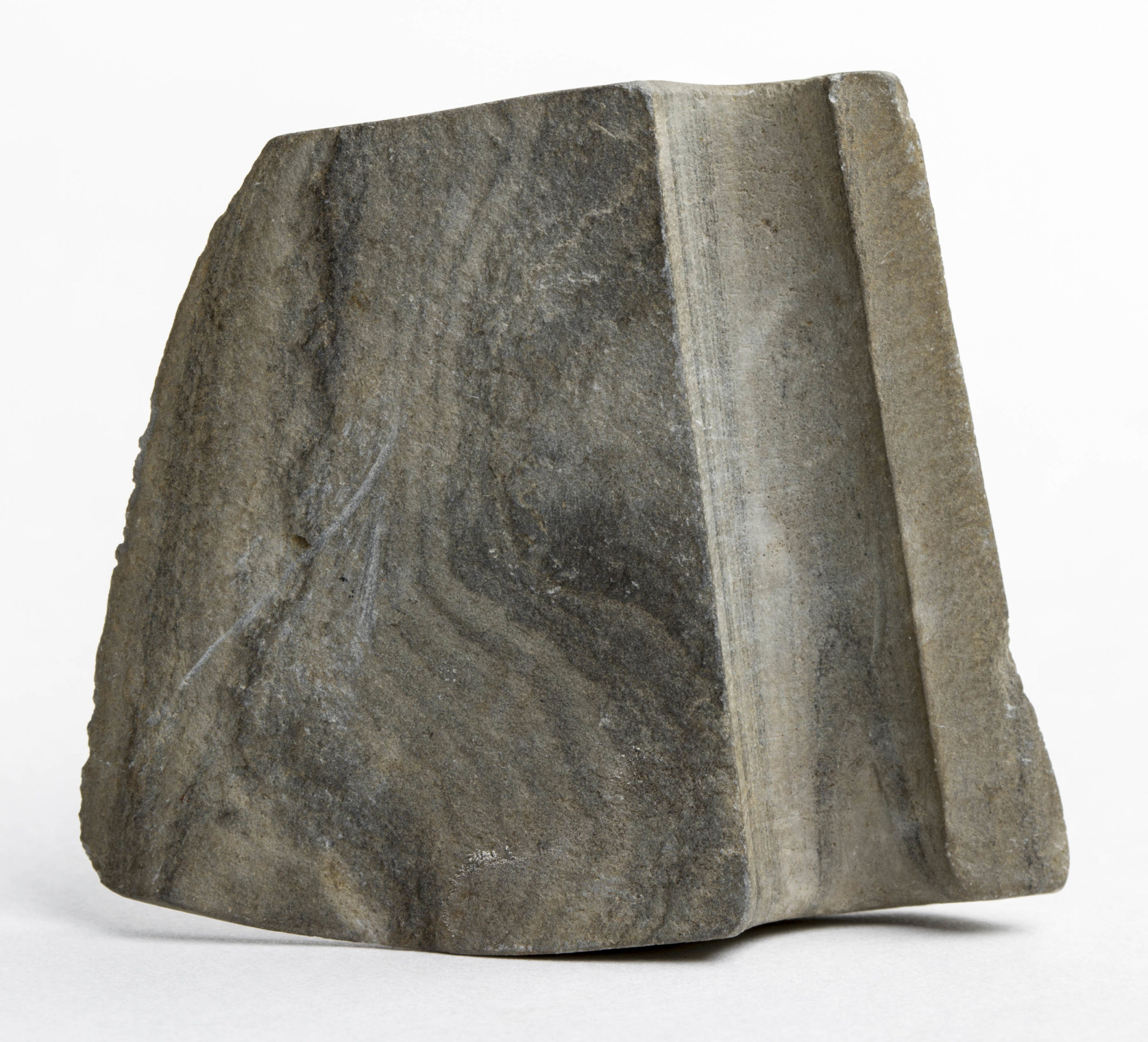
Southern Ovate Preform Bannerstone; Habersham County, Georgia, 6,000 – 1,000 BCE, igneous, coarse-grained alkaline, h. 11.5, w. 10.3 cm; AMNH 2/2205
Unfinished bannerstones
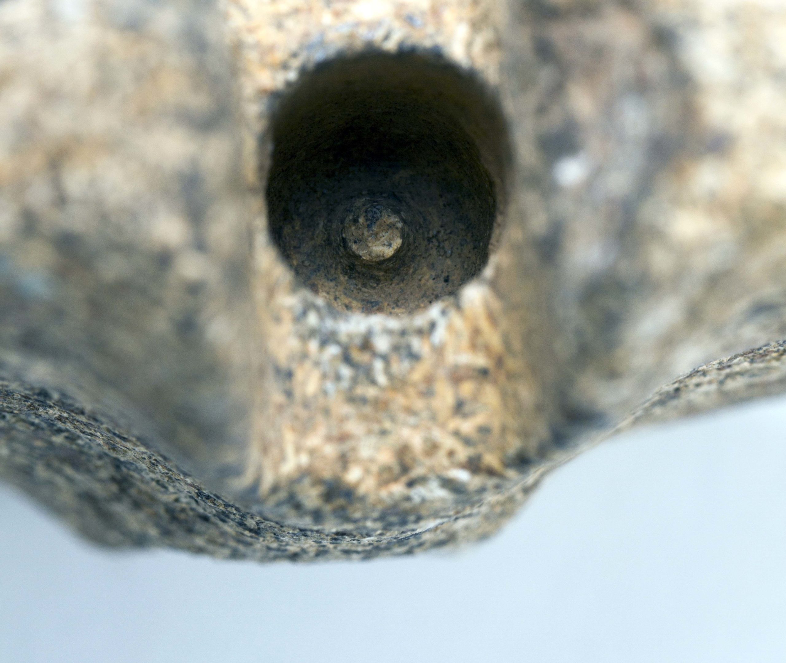
Whatever their shape or relative state of completion, all bannerstones were made using river-worn pebbled hammerstones to peck, grind, and polish the surface. Some bannerstones, however, were intentionally left in a partial state of completion known as a “preform” such as a Southern Ovate from Habershan County, Georgia.
Southern Ovate Preform Bannerstone; Habersham County, Georgia, 6,000 – 1,000 B.C.E., igneous, coarse-grained alkaline, 11.5 x 10.3 cm (American Museum of Natural History 2/2205)
Southern Ovate Preform Bannerstone; Habersham County, Georgia, 6,000 – 1,000 B.C.E., igneous, coarse-grained alkaline, 11.5 x 10.3 cm (American Museum of Natural History 2/2205)
This bannerstone is partially drilled at the spine on one side with a hollow cane or reed that grow along the banks of rivers, and undrilled at the other side. The reed itself is hollow and when rubbed briskly between the hands with the application of water and some sand, can drill through slate, granite and even quartz. With this stone the partial passing of the reed leaves concentric circles on the inside of the perforation and a small nipple visible here that would fall out the other side when the perforation was complete. The medium to coarse-grained igneous rock is left unpolished, just as the ovate form and perforation are left unfinished. Scholars believe that preforms such as these were often buried in this state, or meant to be finished at a later date by another sculptor in a different location. The kind of granite we see here is unique to this region of the Southeast and so would likely have been valuable as a trade good further west along the Mississippi where there was little or no stone available. By partially completing the Ovate form, even partially drilling the perforation the sculptor of this southeastern stone increased the value of the stone while leaving the finish work to whomever acquired this Ovate in this preform state.
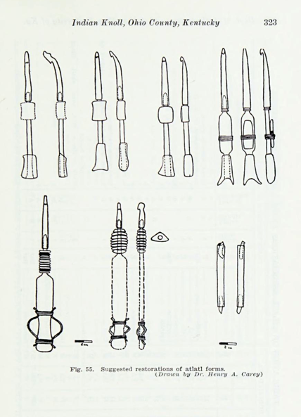
Illustration in William S. Webb, Indian Knoll, 1946 (publication of his 1937 study at Indian Knoll), p. 322
Hunting tools?
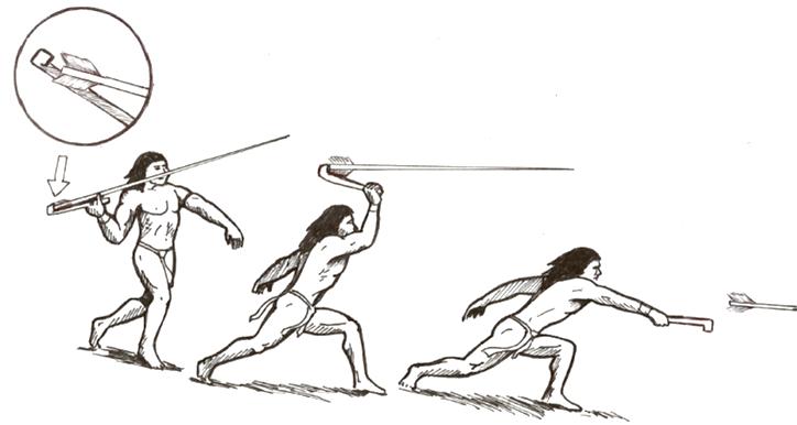
In 1937, William S. Webb, at the University of Kentucky, with his large crew of Works Projects Administration (WPA) workers funded by the New Deal in the 1930s, excavated 880 burials at the Indian Knoll site in Western Kentucky. Amongst these 880 human burials, Webb found 42 bannerstones buried with elements of throwing sticks known as atlatls. Webb proposed that the bannerstones were weights that had been made to be placed on the wooden shafts of these hunting tools. The first inhabitants of Eastern North America used atlatls instead of the bow and arrow until 500 C.E. The two-foot long shaft of the atlatl could propel a six-foot spear and point great distances with accelerated speed and accuracy. It is a tool invented and used in Eurasia and Africa as early as 40,000 B.C.E. and ubiquitous throughout the Americas after it began to be inhabited thousands of years later.
How to use an atlatl (mage: Sebastião da Silva Vieira, CC BY 3.0)
Though many scholars after Webb, including myself, agree that many bannerstones were likely carved and drilled to be placed on atlatl shafts, this particular hypothesis raises as many questions as it may appear to answer. For instance why would these Native American sculptors dedicate so much time to an atlatl accessory that appears to have nominal if any effect on the usefulness of the tool? This raises other unanswered questions about the usefulness of beauty and how aesthetics, pleasure, and play are significant, though often overlooked, elements of ancient Native North American art.
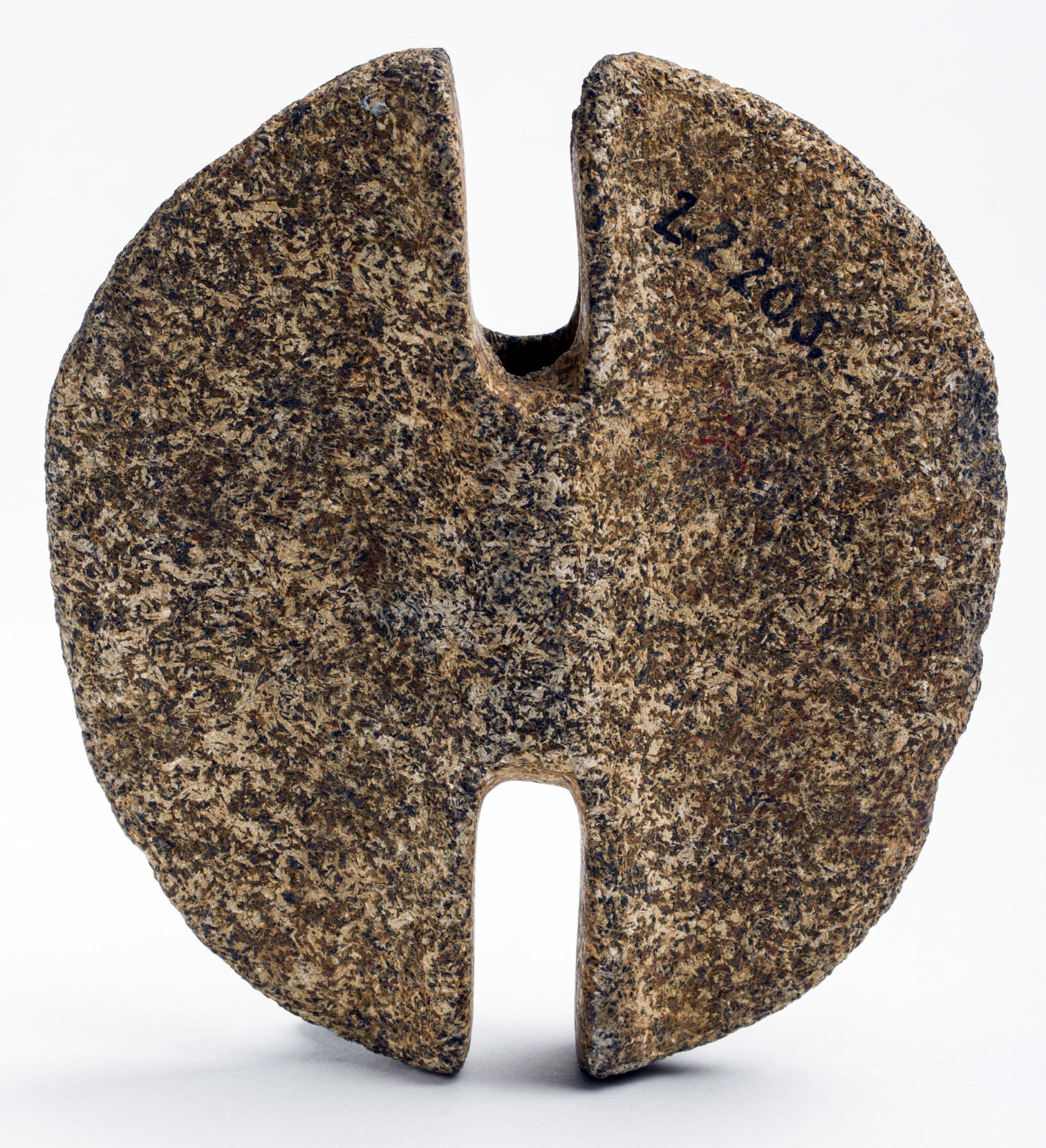
Partially destroyed double crescent type bannerstone (American Museum of Natural History DM 333)
NAGPRA
Since Webb’s 1936 excavation at Indian Knoll, Kentucky, remains and belongings of Native Americans are no longer simply there for the taking for the collector’s shelf, college laboratory, or museum case. Especially with the passage of the Native American Graves Protection and Repatriation Act of 1990 (known as NAGPRA), funerary remains of Native Americans (bodies and objects placed with these bodies in burials) are protected from being disturbed or excavated unless permissions have been granted by Native communities culturally affiliated with the burials. [1] Native American funerary objects already in federal agencies or museums and institutions that receive federal funding are to be made available to culturally affiliated communities that have the right to request their repatriation. Whatever the aims of post-Enlightenment science or the elucidating potential of the exhibition of artworks may be, these ideological motivations must be negotiated with and in light of the desires, memories, practices, and philosophical underpinnings of the Native American people and their descendants who often buried their dead with bannerstones and other burial remains.
Currently the William Webb Museum has recently removed all photographs of the 880 burials and 55,000 artifacts that Webb excavated at Indian Knoll in 1936 and will no longer allow scholars to study these remains “until legal compliance with NAGPRA has been achieved.” What “legal compliance with NAGPRA” specifically means for the remains including bannerstones excavated at Indian Knoll is profoundly complex. No living communities of Native Americans trace their direct line (in legal terms, known as “lineal descendants”) to the Archaic people who built this shell mound in which they buried their dead along with valued objects including broken and unbroken bannerstones. With the ratification of the Indian Removal Act of 1830, the Shawnee and Chickasaw communities that lived in Western Kentucky in the 19th century were forced to move west to Oklahoma. [2] How the William Webb museum will choose to adhere to NAGPRA and what they will do with burial remains from Indian Knoll will set a precedent unfolding into the present about how to collaborate with living Native American communities (even those who are not “lineal descendants”), and how to mindfully regard the past lives of the Ancient people of North American, their human remains along with the multitude of things they made, valued, and arranged in and outside of burials.
Intentionally broken?
Since the 19th century, many bannerstones were found in ancient trash piles known as “middens” as well as ritual burials of things known as “caches” and many more in human burials in subterranean or earthen mound architecture. A large number of bannerstones have also been found broken in half at the spine where they are most fragile due to the thin walls of the drilled perforations.
Broken butterfly type bannerstone (American Museum of Natural History 20.1/5818)
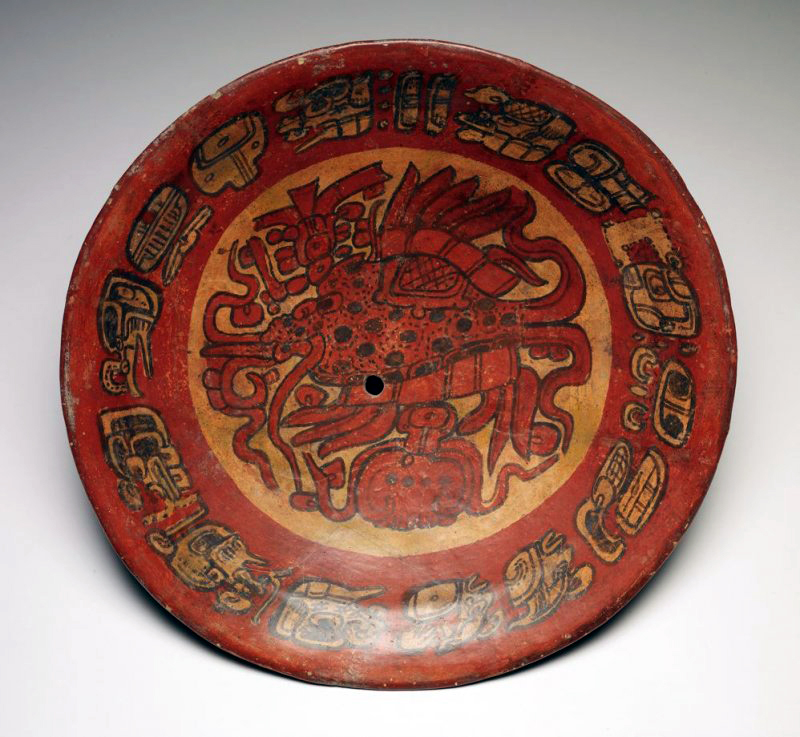
Kill hole in the center of a plate with a supernatural fish, 7th century, Late Classic Maya, earthenware and pigment, 10.5 x 40.6 x 40 cm, Guatemala (De Young Museum)
The intentional nature of these acts of breaking are evident in the placement of pieces together with no sign of wear along the broken edges, carefully arranged with other valuable objects. Archaeologists and historians of the ancient art of the Americas amongst the 8th century-Maya (of Mesoamerica) or 12th-century Mimbres art (of what is today the southwestern U.S.) have often identified this practice as “ritually killing” the object before burial. Though these bannerstones in most cases were intentionally broken by the very people who carved them (most likely just before burial), the meaning and purpose of this act further reveals something about the conceptual and even poetical importance of these sculpted bannerstone forms. Rather than “ritually killing,” bannerstone makers as well as other artists of Ancient America appear to be repurposing artworks, using them in one way at first, then reconceptualizing them to accompany their dead underground, as a kind of memory-work for the living not entirely unlike the carefully constructed exhibition spaces or storage units of our museums. For the Indigenous people of the Americas the earth itself was often seen as a repository for cultural and personal objects, an underground space that was curated with things that continued to have meaning for the lives of communities for decades and even centuries.