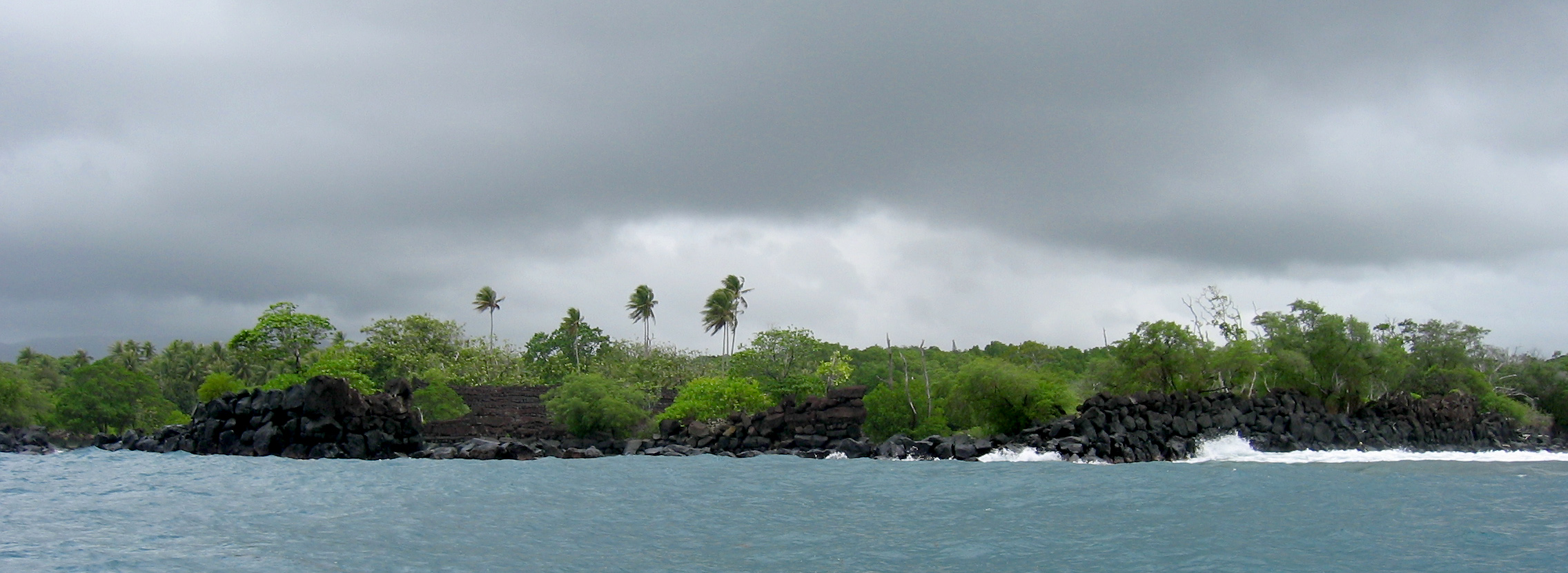
Chief Roi Mata’s Domain is the first site to be inscribed in Vanuatu. It consists of three early 17th century AD sites on the islands of Efate, Lelepa and Artok associated with the life and death of the last paramount chief, or Roi Mata, of what is now Central Vanuatu. The property includes Roi Mata’s residence, the site of his death and Roi Mata’s mass burial site. It is closely associated with the oral traditions surrounding the chief and the moral values he espoused. The site reflects the convergence between oral tradition and archaeology and bears witness to the persistence of Roi Mata’s social reforms and conflict resolution, still relevant to the people of the region.
Europe does not border the Pacific, and reaching the Pacific Ocean required European explorers to either pass around or across the Americas, to navigate around the tip of Africa and through the Indian Ocean, or to traverse Asia by land. Despite the significant obstacles, and the length of the journey from Europe to the Pacific, it was not long after Christopher Columbus crossed the Atlantic that Europeans began to explore the Pacific Ocean.
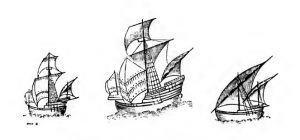
Reproduction of a sketch of the three vessels of Columbus’s first voyage across the Atlantic, possibly drawn by Christopher Columbus. 1893. From HathiTrust. Public Domain
European determination to reach the wealth of Asia had led Columbus to ‘voyage west to reach the east’, a voyage sponsored by the Spanish monarchs Ferdinand of Aragon and Isabella of Castile in 1492. Columbus had previously promoted his ambition to reach China by sailing west to other European monarchs, but they had not supported his plans. Those monarchs were unenthusiastic not because of the prospect of sailing off the edge of a flat earth, but because they were reliably informed that Columbus had miscalculated the circumference of the world, and as a result had significantly underestimated how far he would have to sail to reach Asia.
When Columbus returned from his first voyage, he was convinced he had succeeded with his plan. How long he remained convinced of an Asian landfall is disputed by historians, and he may not have realised he had found something new and unexpected even after his fourth return voyage across the Atlantic. The prospect of having discovered a ‘New World’ (a term used to refer to the Americas, and one that distinguishes it from the ‘Old World’ of Europe, Asia, and Africa) was difficult to grasp as it seemed to contradict both the Christian Bible and previously trusted authorities on the structure of the world.
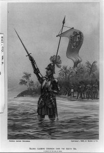
Nineteenth-century image depicting Vasco Nunez de Balboa reaching the Pacific after crossing the Darien Isthmus. c.1893. From the Library of Congress. Public Domain
Despite this cosmological discombobulation, the Spanish moved quickly to try and find ways to profit from the newly encountered regions: colonisation and conquest followed contact. Columbus first encountered the Americas in 1492, and he attempted to found a European settlement on the island of Hispaniola during that first voyage. Further contact followed, and a permanent settlement was established on the island in 1496. With a foothold established in the Caribbean, the Spanish then attempted to colonise the mainland. It was by travelling over land that the Spanish first reached the Pacific: Vasco Nunez de Balboa led an expedition that crossed the Darien Isthmus in 1513, looking for the great ocean local people had told him about. That isthmus is the present-day site of the Panama Canal and is a narrow strip of land that separates the Pacific from the Atlantic Ocean. On 29 September 1513 Balboa waded into the saltwater of the Gulf of San Miguel to claim the ‘southern’ sea for Spain (by a quirk of geography the Darien Isthmus runs east to west, and Balboa was facing south when he first saw the Pacific: the origin of the term the South Seas).
Spanish interest in the Americas continued to increase throughout the sixteenth century, and other Spanish conquistadors made their way to the Pacific coasts of Mexico and Peru. Between 1519 and 1521 Hernan Cortes famously conquered the vast Aztec empire. He then went on to claim approximately 500 leagues of the shores of the South Sea in 1594, and to explore along the Californian coast in 1539. In the early 1530s Francisco Pizarro emulated Cortes by conquering the Incan empire in Peru. That empire was oriented towards the Pacific, with mountains blocking the coastal plain from the interior of the South American continent. Pizarro’s successful campaign exploited coastal connections, cementing the significance of overland routes to the Pacific. The conquest of Peru was linked to that first glimpse of the Pacific by the Spanish: Pizarro had been a member of Balboa’s 1513 expedition.
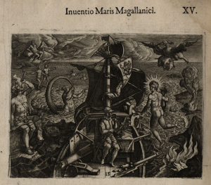
Illustration of Magellan entering the Pacific, published in Theodore De Bry, America part IV, 1594. From Bodmer Lab, Fondation Martin Bodmer, and Universite de Geneve. Public DomainDespite these overland routes, it is the 1519 voyage of Ferdinand Magellan that is commonly associated with the entry of Europeans into the Pacific. Magellan entered the Pacific after working his way through the Straits of Magellan in the far south of South America. Magellan’s voyage left Europe with 237 members and five ships; by the time it returned to Europe at the end of its circumnavigation, it consisted of 35 men and one ship, and Magellan himself was not among the circumnavigators. He had been killed during a battle with an indigenous ruler in the Philippines, possibly as the result of a plot by an enslaved member of his expedition, Enrique. Enrique may well have been the first person to circumnavigate the planet: while not originally from the Philippines, Enrique was Malay. He was able to communicate with local people in the Philippines because he had returned to a trading region that stretched through southeast Asia.
Despite the horrors of Magellan’s voyage, which included inadequate rations, scurvy, mutiny, the desertion of a ship while the expedition was still in the Atlantic, the violent death of the captain, and conflict with the Portuguese in the Spice Islands, the voyage made a profit by returning with a ship loaded with spices. Of significance for the subsequent history of European exploration of the Pacific, Magellan’s expedition marked the Straits of Magellan on European maps, creating a sea route from Europe to the new ocean. And Magellan’s voyage marked the first circumnavigation of the world by Europeans, a remarkable event.
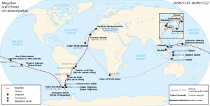
Map showing the route taken by the Magellan expedition. 2008. By Semhur and from Wikimedia Commons. CC BY-SA 3.0In the wake of Magellan other Spanish navigators sailed the Pacific. Some entered through the Straits of Magellan, thought to offer a narrow passageway between the Americas and the Southern Continent. Other navigators travelled a familiar route between Acapulco (in Mexico) and Manila (in the Philippines) as Spanish colonists in South and Central America sought to convert American silver into the desirable Asian goods that had prompted Columbus’s first voyage. The ships that sailed this annual trading mission along known latitudes were collectively known as the Manila Galleon, and the route was regularly employed between 1565 and 1815 (a period of 250 years). The wealth extracted from the Americas by the Spanish, and its concentration on board these ships, served to entice navigators of other nations into the Pacific.
Exploration of the Pacific in the period immediately after Magellan’s voyage was conducted by captains employed by Spanish monarchs (or by their representatives in South America). It was limited in extent, and in the knowledge of the Pacific it generated. Voyages set off directly from Spain or departed from Spanish Peru, but difficulties in determining longitude meant that the Pacific could not be accurately charted. The route of the Manila Galleon in the north Pacific did not lead to new knowledge of the region as captains followed known routes along known latitudes precisely to avoid contact with the unknown.
However, the Pacific was not to remain (from the European perspective) a ‘Spanish Lake’. The prospect of crossing the Pacific to access the known wealth of Asia, the presence of American gold and silver concentrated on Spanish vessels or in Spanish coastal settlements, and the persistent myth of a treasure-laden Southern Continent, served to draw other navigators to the region.
Europeans explore (and imagine) the Pacific’s islands
Captain Cook’s Endeavour voyage in 1770 was part of a growing European presence in the Pacific from the late eighteenth century onwards. While the Manila Galleon had plied its familiar route since 1565, Spanish exploration of the region was limited. Similarly, English pirates might have pursued the Galleon, but they had not mapped the Ocean. And despite the voyages of Abel Tasman and Jacob Roggeveen into the Pacific itself, the Dutch presence had largely remained west of the Australian continent, and had concentrated on avoiding undesirable landfall, rather than exploration. This changed as European technology improved and European explorers became better able to meet the challenges of reaching and navigating Oceania. But while their technology had improved, in many ways European explorers in this period were seeking the same things in the Pacific as their predecessors, and they were similarly guided by preconceptions when interpreting and reporting their Pacific encounters.
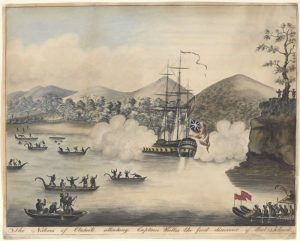
Painting showing violent conflict between Wallis’s ship and Tahitians. c.1767. From National Library of Australia. Public Domain
In the late eighteenth century, the number of Europeans entering the Pacific increased markedly, and European exploration of the region became more systematic. As a result, more islands were encountered, and the positions of those islands began to be calculated and recorded with some degree of accuracy. Key in this process of increasing contact between Europeans and Pacific Islanders was the island of Tahiti. That island was first encountered by Europeans on 18 June 1767, when it was sighted from the Dolphin (a ship under the command of Samuel Wallis). The Dolphin was on its second voyage to the Pacific, the first had taken place in 1764-5 under John Byron. While European vessels were beginning to reach the Pacific repeatedly by this point, they were often short of food supplies and drinking water during their voyages across the vast ocean. When it reached Tahiti in 1767 the Dolphin was in desperate need of supplies, and the officers could not determine how far away the nearest known port lay. As a result, the desperate crew resorted to violence in the face of local people who asserted their control over their land and resources. After suffering significant casualties from European canons and firearms, the Tahitians sought to control their insistent guests through overwhelming hospitality. In doing so, they helped create a persistent European myth of luscious Pacific places and people.
On the Dolphin’s return to England Tahiti was identified as an excellent location from which to observe a rare astronomical event, the transit of Venus. Accurate measurements of the transit, taken from widely flung regions of the planet, would provide data for calculations to determine distances between the sun and its planets. The Endeavour was dispatched in 1768 for what would be a three-month stay in Tahiti. During that time Tahiti was accurately charted, and its longitude calculated, meaning that it could be placed on European maps with certainty.
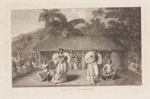
Illustration of a Tahitian dance performance. 1784. By John Webber, John Keyse Sherwin and from Te Papa. CC BY 4.0
In the time between the voyages of the Dolphin and the Endeavour, the French naval explorer Louis-Antoine de Bougainville also ‘discovered’ Tahiti. Informed by their encounter with the English, the Tahitians placated their visitors from the very first, and created a perception among the French voyagers that a place of free love and plenty of the type only dreamed of in Europe actually existed in the Pacific. Thus, the myth of Tahiti took root in Europe, bolstered by multiple accounts from different voyages that either ignored the violence of Wallis’s initial encounter, or were ignorant of it. In creating the myth of Tahiti, Europeans continued a tradition of using recently encountered societies to critique their own: while European philosophers might speculate on the benefits of living closely with nature and participating in free love, they were basing their ideas on vague impressions, not close and accurate observations of island societies. Their assessments were of European civilisation and of their own societies, and their knowledge of Pacific Islanders was slight.
Travel poster promoting Hawai’i. c. 1950. By Joseph Feher and from FreeSVG. CC0 Public Domain
The perception of Tahiti as an earthly paradise continues to the present, supported by a tourism industry that deliberately feeds these old European myths. And Tahiti is not the only region of the Pacific to have been interpreted as paradise by European visitors. Hawai’i became a significant resupply port in the fur trade between North America and China, and was annexed by the United States in 1898. By the time of annexation, the islands were already a tourist destination and were connected to the United States by subsidised steamship lines. Hawaiian tourism intensified through the twentieth century, and the image of Pacific Island paradises persists into the twenty-first. Recent tourism campaigns by Pacific Island nations tap into very old European ideas about the regions at the edge of the map, and what might be found there.
The inhabitants of different regions of the Pacific were interpreted differently, in line with Europeans’ varied expectations of ‘savages’. Tahitians, Hawaiians, and at times Samoans were interpreted as ‘soft’ savages and subjected to a range of related interpretations. These islanders were interpreted as close to nature, useful and diligent (suitable as servants, but not equal to Europeans), and often as being at risk of decline or dying out through their contact with European civilisation. This fear of the Pacific representing a fading golden age, often associated with Europe’s classical age, was persistent and is exemplified in Paul Gauguin’s images of Tahitians, painted in the late nineteenth century. In other places explorers recognised that they were unwelcome, and typified Pacific Islanders as ‘hard’ savages who were warlike, uncivilised, and unfriendly. In those places Europeans tended to interpret Pacific Islanders as leading lives that were ‘solitary, poore, nasty, brutish, and short’ in line with Thomas Hobbes’s earlier description of what it was to live without effective government. These visions of Islanders had their origins in Europe, rather than the Pacific.
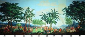
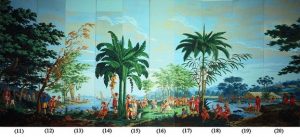
Wallpaper produced by Jean Gabriel Charvet, based on explorer accounts of the Pacific. c.1804-1806. From Wikimedia Commons. Public DomainWallpaper produced by Jean Gabriel Charvet, based on explorer accounts of the Pacific. c.1804-1806. From Wikimedia Commons. Public Domain
The journals kept by European explorers record the early period of contact between Europeans and Pacific peoples. They are remarkable documents that provide eyewitness accounts of eighteenth-century island societies, but their contents record a reality filtered through European expectations. Since the 1960s anthropologists, historians, and other scholars of the Pacific, have worked to decode these observations, highly coloured by European preconceptions, and to understand the island societies of that time in their own terms. Despite the European expectations that coloured explorer observations, recent scholarship has demonstrated that the explorers’ journals offer insights into Islander experiences of this period of encounter and shed light on the way in which European misunderstandings at times led to offence and conflict as they unwittingly insulted their island hosts or acted in culturally unacceptable ways.
The late eighteenth century marked an acceleration in contact between European and Pacific peoples. European technology allowed voyaging to become more manageable and the location of islands to be recorded with some accuracy. However, Europe’s embrace of science and technology did not free Europeans of their expectations, and European explorer journals from this period offer insight into both Pacific and European societies. The Pacific that was becoming known to Europe was in many ways a distorted reflection of European societies, as Europe used the Pacific to think with. The images of island paradises that European thinkers built using explorers’ accounts of their experiences were sufficiently compelling that they can still be detected in the present.
Europeans begin to explore the Australian continent
European exploration of the Australian continent mostly followed colonisation, rather than colonisation following exploration: when Sydney was founded in 1788 not even the outline of the continent was fully known. At that time, for Europeans, there was the possibility that New South Wales (the eastern edge of which had been mapped by James Cook) was not the same landmass as New Holland (the western portion of the continent, with a coastline in part mapped by Dutch navigators). The Sydney settlement was slow to spread inland, and in its early years was more tightly tied to the Pacific on its doorstep than to its continental hinterland. As other British colonies were established on the continent that pattern was repeated: colonisation led to exploration, not the other way round.
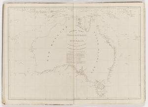
Map of Australia published in Matthew Flinders’ account of his voyage. 1814. From the State Library of New South Wales. Refer to SLNSW for usage rights
As the edges of the Australian continent were being charted by ocean-going explorers and voyagers, the continental interior remained a blank space on European maps. Famously, James Cook produced a detailed map of large portions of the east coast during his 1770 voyage along it, and by the time of Cook’s Endeavour voyage portions of the north, west, and south coasts had been surveyed and partially mapped by a variety of European explorers. The establishment of Sydney did not immediately lead to increased European knowledge of the continent. A quirk of geography meant that the settlement was able to spread only a short way inland before being caged in by the hills and mountains of the Great Dividing Range. The settlement initially spread to encompass the welcoming, coastal Cumberland Plain, but then faced significant barriers before it could tap into resources further inland. Early Sydney sought its supplies in Tahiti and Aotearoa (New Zealand) and those vital connections confirmed the colony’s position: it was a coastal rather than a continental settlement, and the Pacific on its front door step was of greater significance to its survival than the continent behind it.
Once Sydney was established as a European base, coastal exploration of the Australian continent intensified. In 1795 coastal exploration to Sydney’s south by Matthew Flinders and George Bass established that the scrap of coast mapped by Tasman (named Van Diemen’s Land) was part of an island (in 1856 that island became a colony separate from New South Wales and officially took the name Tasmania). The charting of Bass Strait (between Van Diemen’s Land and the continent) promised quicker transit from Britain to Sydney by sea. Between 1801 and 1803 Flinders captained an expedition that undertook the first close circumnavigation of the Australian continent. His journal and the map he constructed were not published until 1814. They contained the first clear map of the coast of the Australian continent, and a proposal that it be named ‘Australia’. As a result of Flinders’ 1801-3 voyage it was finally clear what landmass was in the process of being colonised by the British, although that map only clarified the coast, and left the inland almost entirely blank.
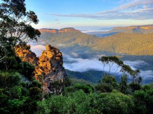
Photograph of terrain typical of the Blue Mountains west of Sydney. 2019. By Abracadebra68 and from Wikimedia Commons. CC BY 4.0
The settlement of Sydney soon sought to break out of the Cumberland Plain, but European explorers struggled to find a way through the Great Dividing Range—that extensive range of mountains and hills that divides the east coast of Australia from the interior and that marks the watershed of the eastern continent. The settlers of Sydney had made multiple attempts to find a way through the Blue Mountains to the settlement’s west, but only succeeded in 1813. Once that barrier had been successfully crossed (25 years after the establishment of the Sydney colony), European exploration of the interior could begin.
British interests had not waited for exploration of Sydney’s hinterland before establishing other colonial outposts along the continent’s coast. In 1802 the British formalised their claim to Van Diemen’s Land, in response to concerns about the motives behind Nicholas Baudin’s expedition, a French circumnavigation of the Australian continent that occurred at the same time as Flinders’. British claims to that island were then cemented with the sending of convicts to the Derwent River to establish an outpost in 1803, and the establishment of a second convict settlement on the Tamar River in 1804. Both settlements had unknown hinterlands when established, and were only connected by an overland route in 1807.
In 1823 the Brisbane River and Moreton Bay region were mapped by John Oxley, and again British claims were cemented by dispatching convict settlers. A first attempt at European settlement in the region was made in 1824 at Moreton Bay, but that settlement needed to be relocated in 1825, at which time it was renamed Brisbane. In 1826 a military outpost was established at Albany in the southwest of the continent, and in 1827 Britain claimed the west of the continent, sending convicts to establish a settlement at King George Sound. In 1827 the Swan River was explored, and Perth was established in 1829 as a free settlement (it became a penal settlement in 1849). Similarly, the region that is now South Australia was not staked out using convicts, but still followed the typical Australian pattern of settlement being followed by exploration, rather than the other way around. As did Victoria: Melbourne was first established in 1835 by private settlers. When Australia’s colonies were first established they were fictions and hopes marked onto maps, they did not reflect real European control of the region being claimed.
Once planted, settlements promoted exploration as they sought resources to become self-sustaining. Many European exploring expeditions were pragmatic in their aims: they sought to locate reliable water sources, to map rivers to unlock routes into the interior and provide reliable means of transport, to locate good pasture (generally in association with rivers), and sometimes to locate other natural resources, including minerals. This process was repeated at each new settlement, and those settlements were at first connected by coastal shipping, not by overland routes. The frontiers of European settlement spread inland slowly and unevenly. In Australia, often the frontier spread independently of government control as pastoralists sought resources for their animals while government survey and official land alienation trailed behind.
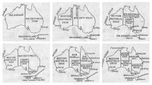
Montage of maps showing progress of Australian settlement. 1916. Images by Ernest Scott (montage by Claire Brennan) and from Project Gutenburg. Public Domain
Cook’s New South Wales came to be divided among the emerging colonies, reflecting the progress of European settlement on the Australian continent. The settlements in Tasmania had occurred early in the colonial process, and in 1825 Van Diemen’s Land separated from the colony of New South Wales. In 1829 Western Australia was proclaimed as a colony, the only Australian colony to form without taking land from New South Wales. In 1834 the province of South Australia was officially proclaimed. In 1841 New Zealand formally separated from New South Wales, following the 1840 signing of the Treaty of Waitangi. In 1851 Victoria separated from New South Wales as European settlement there intensified. And in 1859 Queensland separated from New South Wales. Those dates, while referring to political acts, reflect the staggered arrival of the frontier in different regions of Australia.
But even as settler Australia divided up the continent, it was not not fully explored and known by Europeans. By the late nineteenth century the hope of finding new pastoral regions was dead, and exploration instead used science for its rationale. The difficulties of travelling through the extensive arid regions of the continent (and the lack of tangible rewards for doing so) meant that significant geographical features of the Australian continent remained unknown until the advent of aerial photography. The aerial photographic survey of Lake Eyre in 1922 was a logistical feat, and a milestone in beginning to finalise the map of the interior of the Australian continent. Aerial surveys revealed significant landscape features previously unknown to Europeans, but no new fertile regions came to light. Australian settlement remains largely restricted to narrow bands along portions of the continent’s coast and aerial mapping has finally destroyed the prospect of Australia being the lavish southern continent long imagined by Europeans.
Science, and the Pacific’s role in European thought
The number of European expeditions entering the Pacific increased markedly towards the end of the 1700s, and there was a notable shift in both the objectives and methods of European exploration of the region. Europe was going through a period of significant change, and science was taking up a prominent role in European thinking, a role it still holds. European science shaped exploration of the Pacific, and the Pacific shaped significant aspects of European science. The Pacific offered a region for study, became a laboratory, and played a major role in European thinking about the world.
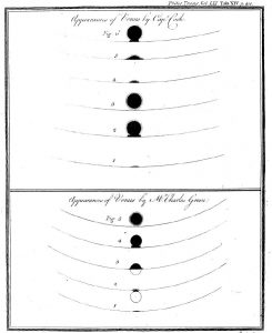
Drawings of the 1769 Transit of Venus by Lt James Cook (top) and Charles Green (bottom) made in Tahiti. 1771. From Wikimedia Commons. Public Domain
The start of science-driven exploration of the Pacific is generally associated with the Endeavour voyage. That voyage was sponsored by the Royal Society, an institution established in 1660 that was central to the development of scientific methods and thinking. The Society’s motto ‘Nullius in Verba’ translates as ‘take nobody’s word for it’ and marked a significant shift in thinking as it endorsed observation and experiment (in contrast to tradition and authority) as sources of knowledge. The Society’s journal Philosophical Transactions established the model of peer-reviewed scientific publication that remains central to research to the present day.
Science was at the heart of the Endeavour voyage. One manifestation was in astronomy. The transit of the planet Venus across the sun that was due to occur in 1769 marked an opportunity to calculate the distance between the earth and the sun that would not be repeated for 120 years. The successful calculation of that distance required astronomers to observe and record the transit at widely spaced localities. Samuel Wallis arrived in England with news of Tahiti at the perfect moment for it to be chosen as a site for European scientific observation and to play a role in establishing the earth’s place in the solar system.
The Endeavour carried a range of scientists, among them Cook who was both a skilled astronomer and an excellent cartographer. The expedition also included an astronomer appointed by the Royal Society, Charles Green. Connections between the expedition and the Society also manifested in the person of Joseph Banks. Banks was a wealthy gentleman, a fellow of the Royal Society, and sufficiently influential to join the voyage in the service of science, and to bring a team of artists and scientists with him. In 1778 Banks became president of the Royal Society, a post he held until his death in 1820. In the wake of the Endeavour the advancement of science became a recognised goal of Pacific exploration by European powers.
And the Endeavour’s scientists made significant contributions to Europe’s scientific knowledge. The Endeavour’s astronomers recorded observations of the transit of Venus from two locations in Tahiti, and those observations played a role in the subsequent calculations that determined distances between objects within the solar system. Banks and his scientists collected 30,000 plant specimens, 1,000 animal specimens, and prepared many scientific drawings. Those collections increased the number of the world’s known plants by one quarter. After his return to Europe, Banks acted as a patron of scientific research, and his Pacific collections both advanced European knowledge of the world, and helped Banks establish his position as a scientific gentleman of renown.
Photograph of type specimen of bougainvillea, collected by Philibert Commerson at Rio at 1767. 2009. From Museum National d’Histoire Naturelle. CC BY 4.0
England was not the only European state interested in scientific exploration of the Pacific. In 1764 France founded a colony in the Falkland Islands as a place of resupply for ships bound for Asia. The location of the Falkland Islands promised France control over shipping in the south Atlantic, but the islands’ location near the Straits of Magellan quickly made them significant for Pacific exploration. Louis-Antoine de Bougainville was involved in the French settlement of the Falkland Islands, and in conceding their sovereignty to the Spanish in 1767. His 1766-9 voyage first travelled to the Falkland Islands to formally hand them over to Spain, then continued to the Pacific. Bougainville’s voyage combined politics, survey, and science: among those travelling on his two ships were the naturalist Philibert Commerson, and his assistant Jean(ne) Baret. Bougainville’s voyage marked an incomplete shift to science as a rationale for Pacific exploration: Commerson made collections and observations, but he did not represent a formal connection between the voyage and scientific institutions in France. He might better be considered a transition between Pacific science undertaken from personal interest, as exemplified by William Dampier, and the formal science of the Endeavour voyage. Even that shift to formal science was incomplete, and science and politics remain tangled. Staking a claim to scientific aims could allow naval ships to move through regions claimed by other European nations, even while at war as scientific passports were widely, although not universally, respected. In addition, claiming a national interest in advancing science was a source of national prestige, particularly for the British and French.
This finished drawing by John Gould illustrates varieties of finches Charles Darwin collected in the Galapagos. 1845. From Wikimedia Commons. Public Domain
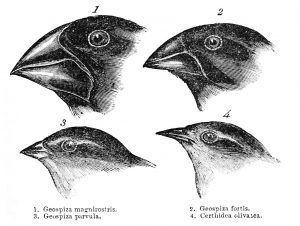
The Endeavour was followed by many vessels carrying scientists and collecting specimens and observations. The voyage of the Beagle in 1831-6 is famously associated with Charles Darwin and the theory of evolution. Many of the observations that informed Darwin in his development of the theory of evolution by natural selection were made during his time in the Pacific. In particular, the finches he observed in the Galapagos Islands provided an excellent example of adaptive radiation. While Darwin’s theory was controversial when first published, it soon became widely accepted and at the time of his death Darwin was accorded a state funeral. The voyage of the Beagle has its place in European mythology: in 2005 a Mars lander was named Beagle 2 in honour of Darwin’s voyage and in expectation that it too would make significant observations of previously unfamiliar environments. Exemplifying the hazards of exploration, it was destroyed on impact with the Martian surface.
However, the Beagle’s voyage was in the service of cartography, and Darwin’s presence was the result of the captain’s desire to take a companion for the long voyage. Robert Fitzroy feared that loneliness (as captain he was unable to socialise with those of other ranks) might lead him to suicide, and Darwin was present to provide him with conversation. Through Darwin, the Pacific played an important role in formulating European ideas about the natural world, and through Darwin travel became clearly associated with the pursuit of science. However, Darwin’s presence on the Beagle was more a continuation of the tradition of Dampier and the interested observer than a shift to voyages of exploration pursuing explicitly scientific objectives.
The rise of scientific thinking in Europe changed the way Europeans approached the Pacific. Voyages became more frequent (in part because of changes in technology), and more closely linked with national navies and national prestige. Science became an important element of European voyages within the Pacific. As a result of the rise of scientific thinking the Pacific took on a new role in the European imagination—that of a laboratory full of curious and revealing facts. And the Pacific helped Europeans find their place in the solar system, and in the natural world.
Banks, Joseph. The Endeavour Journal of Joseph Banks 1768-1771, Volume II. Sydney: The Trustees of the Public Library of New South Wales in association with Angus and Robertson Limited, 1962.http://nzetc.victoria.ac.nz/tm/scholarly/tei-Bea02Bank.html
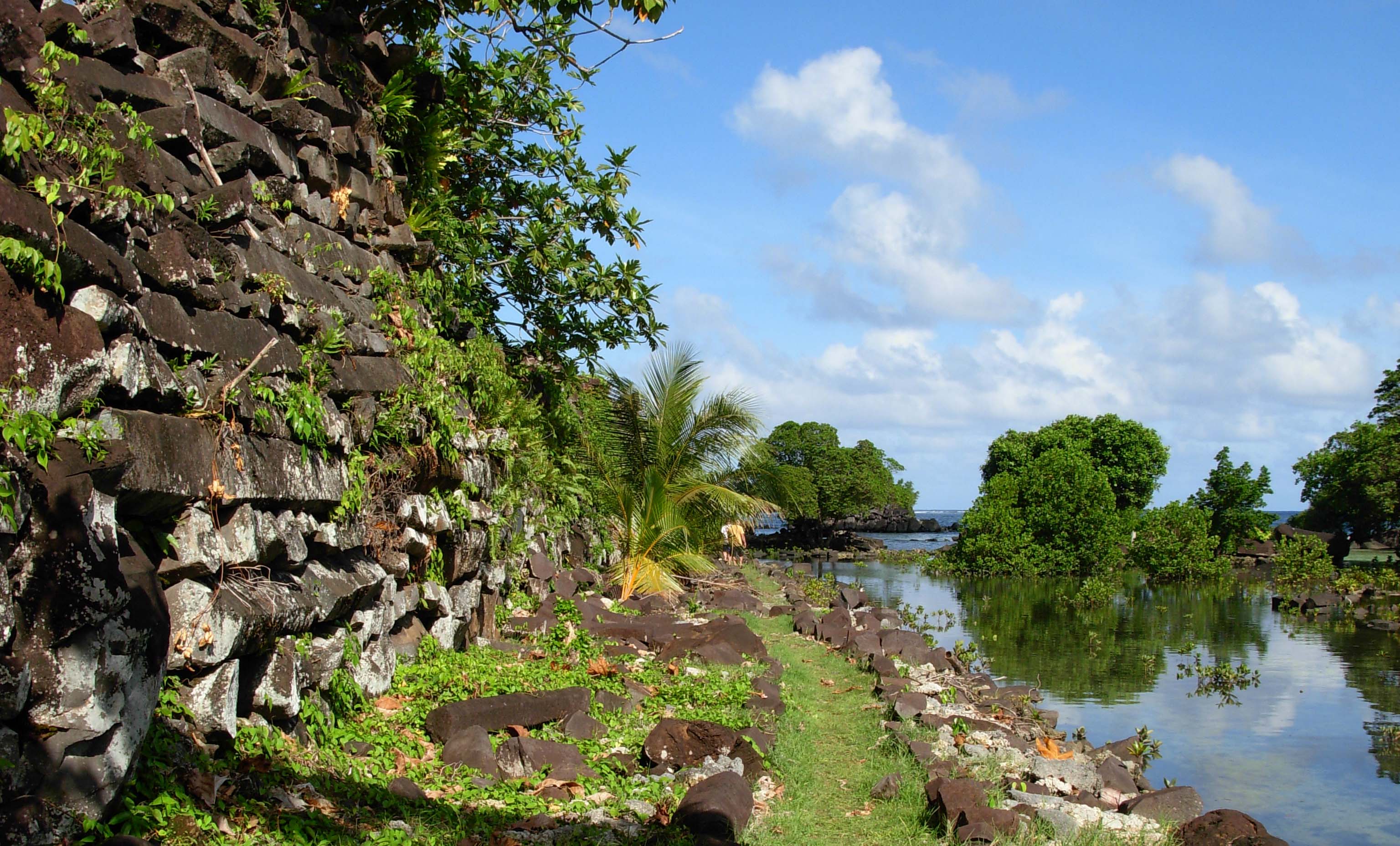
Nan Madol, 13th-17th century C.E., Pohnpei, The Federated States of Micronesia (photo: smwd0030, CC BY 2.0)
How did they do it?
Sometimes art and architecture calls on us to reimagine what we think was possible in the past, and what ancestors were able to achieve. The abandoned megalithiccapital of Nan Madol, located in a lagoon adjacent to the eastern shoreline of the island of Pohnpei in the Federated States of Micronesia in the Pacific Ocean, is a terrific example. [1] Once the political and ceremonial center for the ruling chiefs of the Sau Deleur dynasty (c. 1100–1628), Nan Madol is a complex of close to 100 artificial rectilinear islets spread over 200 acres that are thought to have housed up to 1000 people. Its basalt and coral rock structures were built from the 13th to the 17th century by a population of less than 30,000 people and their total weight is estimated at 750,000 metric tons. Archaeologist Rufino Mauricio pulls these vast quantities into focus for us by explaining that the people of Pohnpei moved an average of 1,850 tons of basalt per year over four centuries—and no one knows quite how they did it. [2]
Basalt structure in Nan Madol, 13th-17th century C.E., Pohnpei, The Federated States of Micronesia (photo: ajdemma, CC BY-NC 2.0)
Immense human power
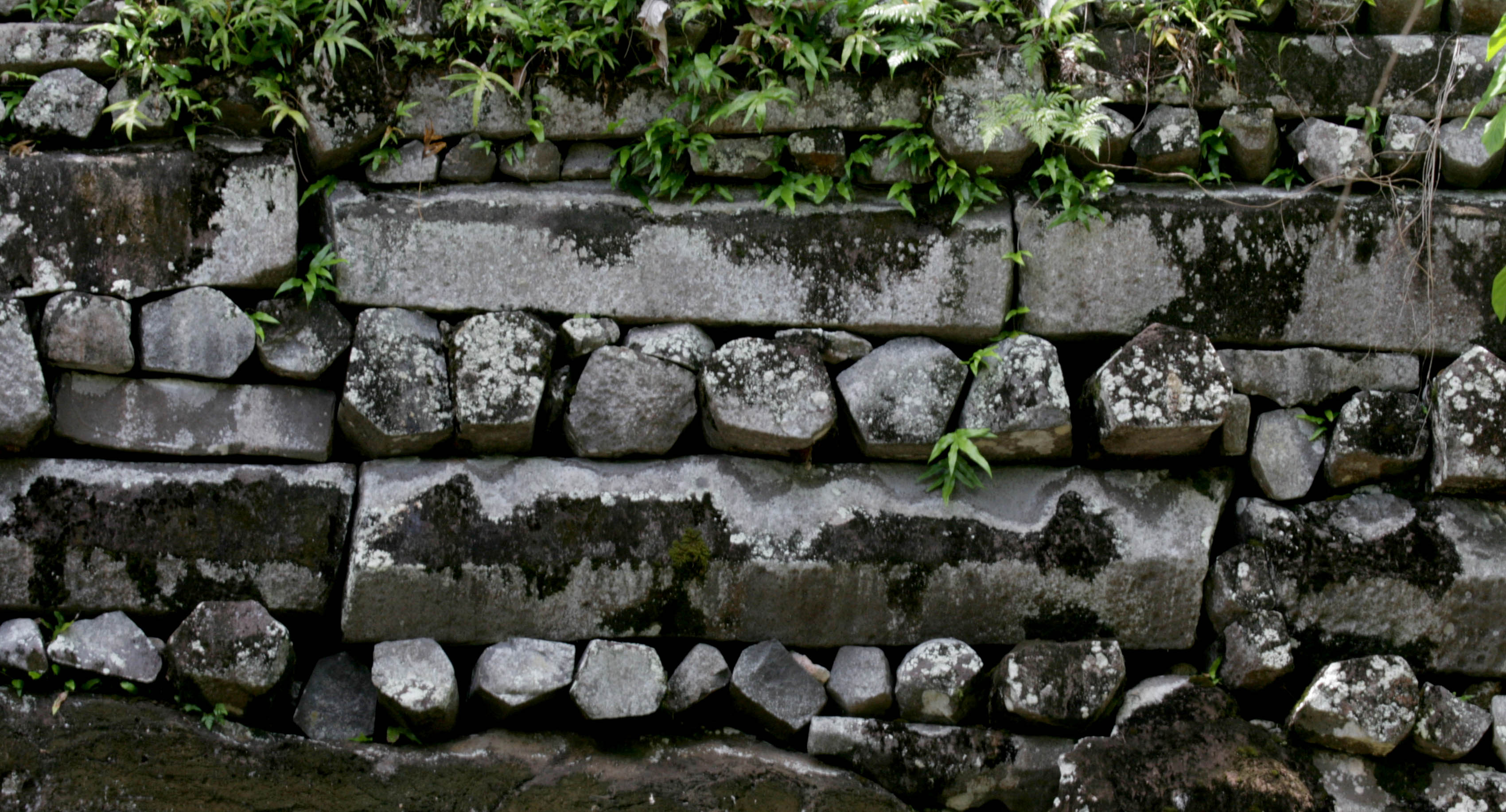
Nan Madol specialist Mark McCoy has used the chemistry of the stones to link some to their source on the opposite side of the island. [3] The creators of Nan Madol managed to quarry columns of basalt from a site in Sokehs, on the other side of Pohnpei, and transport them more than 25 miles to the submerged coral reefs that are the foundations of Nan Madol. There, they used ropes and levers to stack them in an intersecting formation, making raised platforms, ceremonial sites, dwellings, tombs, and crypts. They used no mortar or concrete, relying solely on the positioning and weight of each basalt column, with a little coral fill, to hold each structure in place.
Detail of a wall in Nan Madol, 13th-17th century C.E., Pohnpei, The Federated States of Micronesia (photo: Joyce McClure, CC BY-NC-ND 2.0)
The human power required to move these materials over such an extended period of time and space is evidence of an impressive display of power by the rulers of Pohnpei as well as ecological and economic systems capable of supporting a busy labor force.
Sacred histories
Sometimes oral histories are able to explain the extraordinary feats of men in ways that present-day science cannot replicate. Oral histories of Nan Madol describe great birds or giants moving the basalt rocks into place, others recall the magic used by the twin sorcerers Olosohpa and Olosihpa to create a place to worship their gods. Beyond these creation narratives, aspects of the oral history of Nan Madol, passed down through many generations, correlate with archaeological evidence. For example, oral histories describe a series of canals cut to allow eels to enter the city from the sea. A well on the island of Idehd is said to have housed a sacred eel who embodied a sea deity, and to whom the innards of specially raised and cooked turtles were fed by priests. Traces of the canal system as well as a large midden (mound) of turtle remains on Idehd are among the archaeological evidence that supports these histories.
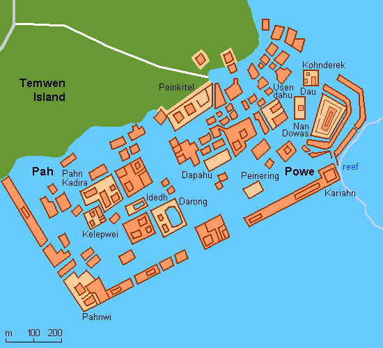
Map of Nan Madol (source: Hobe / Holger Behr, CC0)
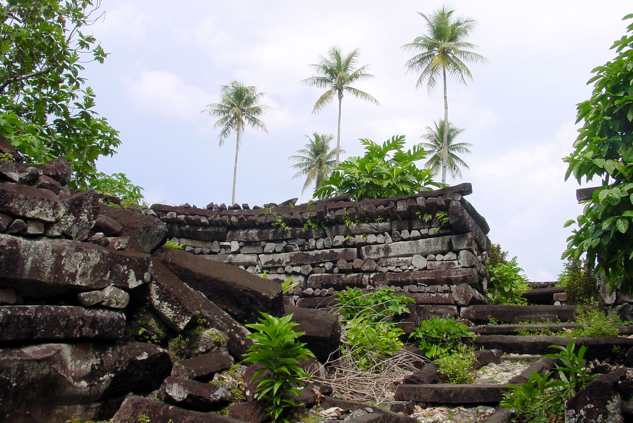
While the exact engineering of Nan Madol eludes us, we know that the construction of elevated, artificial islets had commenced by 900 to 1200 C.E., and that around 1200 C.E. the first monumental burial took place when a chief was interred in a stone and coral tomb. This significant ceremonial event was followed by a period of truly megalithic building from 1200 to 1600 C.E.
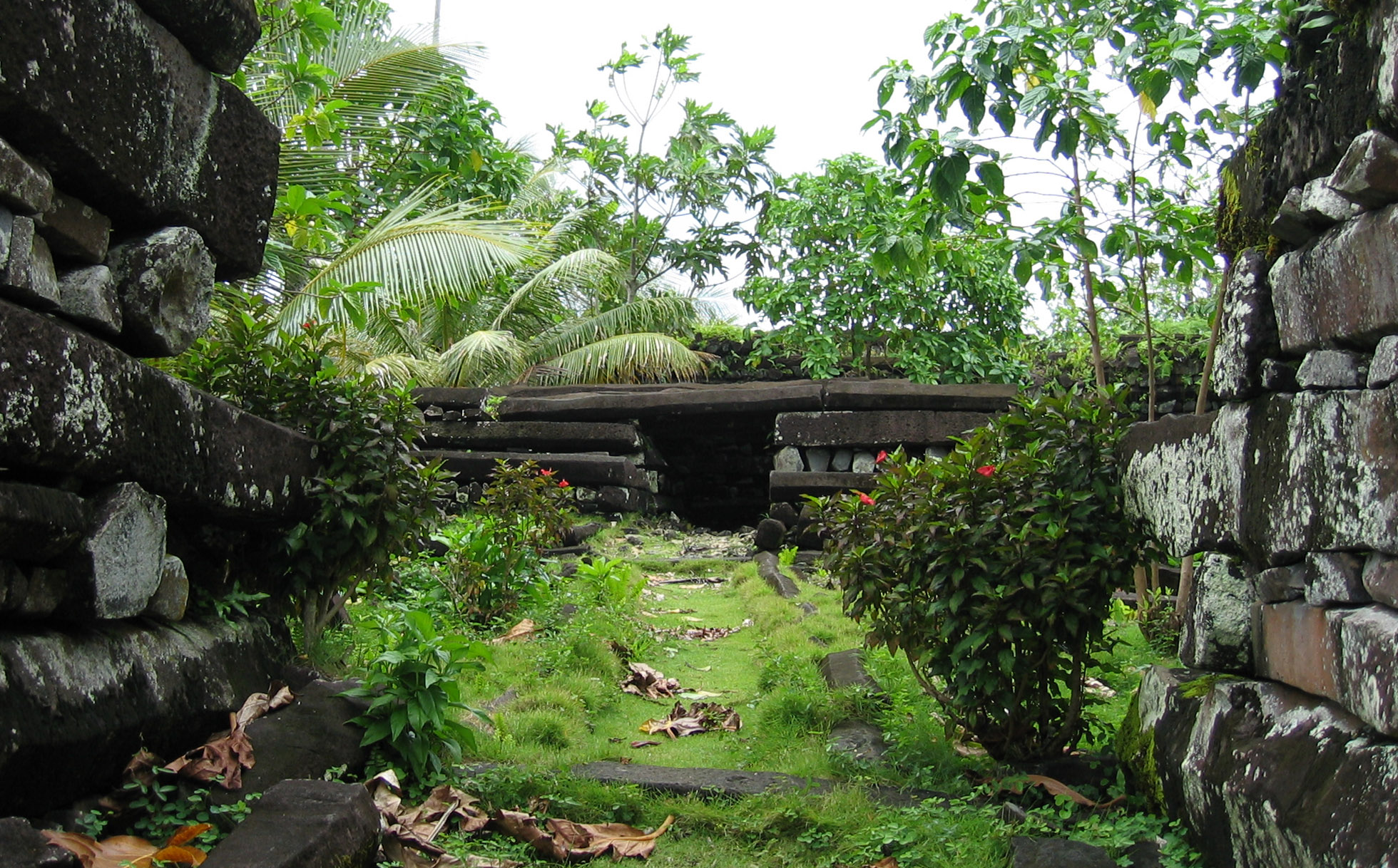
Madol Pah in the southwest was the administrative center of the complex and Madol Powe in the northeast was its religious and mortuary sector. This area comprises 58 islets, most of which were inhabited by priests. The most elaborate building is Nandauwas, the royal mortuary, which covers an area greater than a football field. Its walls are 25 feet high and just one of its cornerstones is estimated to weigh 50 tons. Elsewhere, log-cabin style walls of stone reached 50 feet in height and are 16 feet thick, and were topped with thatched roofs. All were protected from surging tides by large breakwaters and seawalls.
Basalt structure in Nan Madol, 13th-17th century C.E., Pohnpei, The Federated States of Micronesia (photo: ajdemma, CC BY-NC 2.0)
What’s in a name?
Archaeological and linguistic evidence suggest that certain islets were dedicated to specific activities—Dapahu to food preparation and canoe building, and Peinering (“place of coconut oil preparation”), Sapenlan (“place of the sky”) and Kohnderek (“place for dancing and anointing the dead”) to the activities their names describe. Tombs surrounded by high walls can be found on Peinkitel, Karian and Lemonkou.
Powerful rulers
Nan Madol, 13th-17th century C.E., Pohnpei, The Federated States of Micronesia (photo: CT Snow, CC BY 2.0)
Nan Madol is simultaneously an engineering marvel, a logistical puzzle, and the product of a sophisticated economy and highly stratified society—all presided over by a dynasty known as the Sau Deleurs. Who were these leaders who inspired (or perhaps coerced) the people of Pohnpei into such a long-term and physically challenging undertaking? Many oral histories describe them, and there are many possible interpretations of these, but most agree that for many centuries Pohnpei was under the rule of a series of chiefs (Sau) descended from Olosohpa, who began as gentle leaders but came to exert extraordinary power over their people before deteriorating into tyrants. Under their rule the people of Pohnpei not only built the Nan Madol structures, but also made tributes and food offerings to the Sau Deleur, including turtles and dogs, which were reserved for their consumption. This period of history is remembered as the “Mwehin Sau Deleur”—the “Time of the Lord of Deleur.”
The dynasty was overthrown by the culture hero Isokelekel, who destroyed the last of the Sau Deleurs in a great battle. Following his victory, Isokelekel divided power into three chieftainships and established a decentralized ruling system called Nahnmwarki which remains in existence today. He took up residence at Nan Madol on the islet of Peikapw. A century later, his successor abandoned the site and established a residence away from Nan Madol. The site gradually lost its association with prestige and its population dwindled, though religious ceremonies continued to be held here from time to time into the late 1800s.
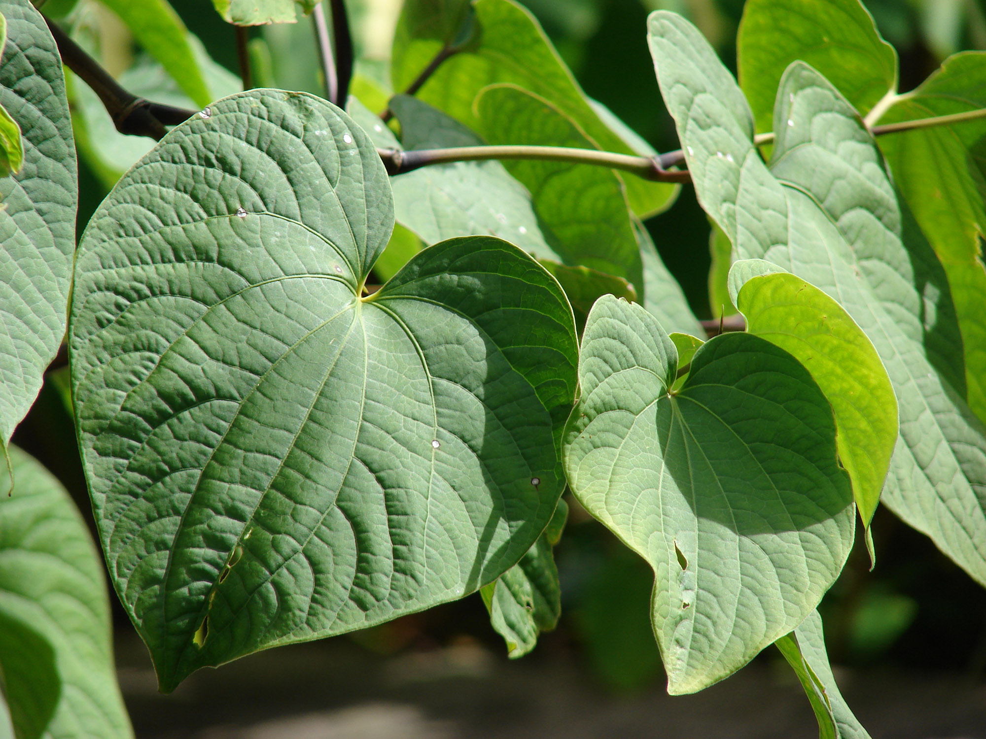
Leaves of the Kava plant (photo: Forest & Kim Starr, CC BY 3.0)
Artifacts found at Nan Madol include stone and shell tools, necklaces, arm rings, “trolling lure” ornaments, drilled porpoise and fruit bat teeth, quartz crystals, lancet and disc-shaped bead necklaces, pottery, remnants of turtle and dog status foods, and large pounders used to process the root of the kava plant (Piper methysticum) into a ceremonial drink. Kava has mild sedative, anesthetic and euphoriant qualities, and its botanical name literally means “intoxicating pepper.” Extensive personal adornments, food, and kava are evidence of Nan Madol’s significance as the ceremonial center of Eastern Micronesia.
The garden of Micronesia
Pohnpei is rich in natural resources and has been called “the garden of Micronesia.” It has fertile soil and heavy rainfall, that promotes the growth of lush vegetation from its coastal mangrove swamps to the rainforests at the apex of its central hills, as well as lagoons. These natural resources would have provided the necessary food for the workers who built the extraordinary complex that is Nan Madol, as well as timber that may have been used to help shift the basalt rocks. It seems unlikely that any foods were cultivated within Nan Madol, and likely no source of freshwater existed within the complex—food and water were brought from the island’s interior.
Detail of a wall in Nan Madol, 13th-17th century C.E., Pohnpei, The Federated States of Micronesia (photo: Wayne Batzer, CC BY-NC 2.0)
The basalt columns used to build Nan Madol are almost as extraordinary as the megalithic structures they comprise. Columnar grey basalt is a volcanic rock that breaks naturally into flat-sided rods when it cools. Though it appears quite marvelously to have been shaped by chisels, its predominantly hexagonal or pentagonal columns are due to natural fractures that form while a thick lava flow cools. Rapid cooling results in slender columns (<1 cm in diameter) while slow cooling results in longer and thicker columns. Some of the columns used to build Nan Madol are up to 20 feet long and weigh 80–90 tons. [4]
Nan Madol, 13th-17th century C.E., Pohnpei, The Federated States of Micronesia (photo: ajdemma, CC BY-NC 2.0)
A space between things
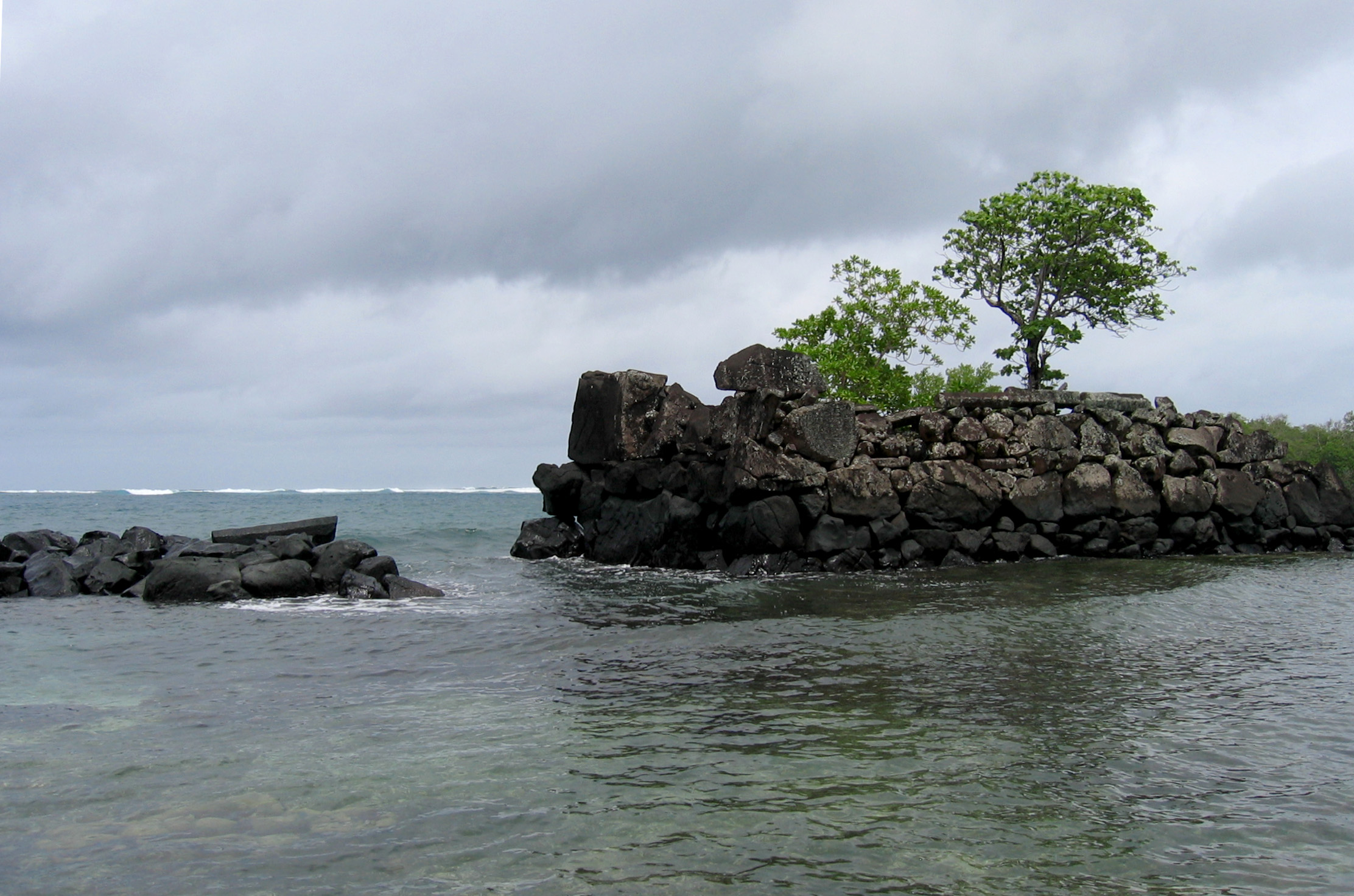
In July 2016, Nan Madol was declared a UNESCO World Heritage Site. The dedicated UNESCO webpage explains that “The huge scale of the edifices, their technical sophistication and the concentration of megalithic structures bear testimony to complex social and religious practices of the island societies of the period.” [5] It also describes how siltation of the waterways that are an integral part of this site is allowing an overgrowth by mangroves. Both the mangroves and the siltation are threatening the structures themselves.
Since Nan Madol was built on a coral foundation, it is sometimes called “the Venice of the Pacific.” Like Venice(which is made up of 117 islands), the islands of Nan Madol are connected by a network of tidal channels and waterways. These are referred to in the name Nan Madol, which means ‘in the space between things’—here, as elsewhere in the Pacific, waterways are described as connectors of people and places rather than barriers. The waterways might be local, like the canals of Nan Madol, or expansive, like the great Pacific Ocean, the largest body of water on Earth.
To get a sense of the extent of this space between things, it is instructive to zoom in on Nan Madol using an online mapping system. Pinpoint Sokehs Pah while you are at it, so you can also see the distance between this quarry and the ancient capital built from its rock supply. Then, frame by frame, zoom out. Marvel at the space that unfolds as you ponder what motivated the Sau Deleur dynasty to build such an expansive, impressive and intimidating structure, and just how they might have achieved this.
“Centres of Power and Monumental Architecture in Micronesia,” in Art in Oceania (Yale University Press, 2013), pp. 58–61
Source: Dr. Billie Lythberg, “Nan Madol: “In the space between things”,” in Smarthistory, August 20, 2018, accessed July 31, 2024, https://smarthistory.org/nan-madol/.
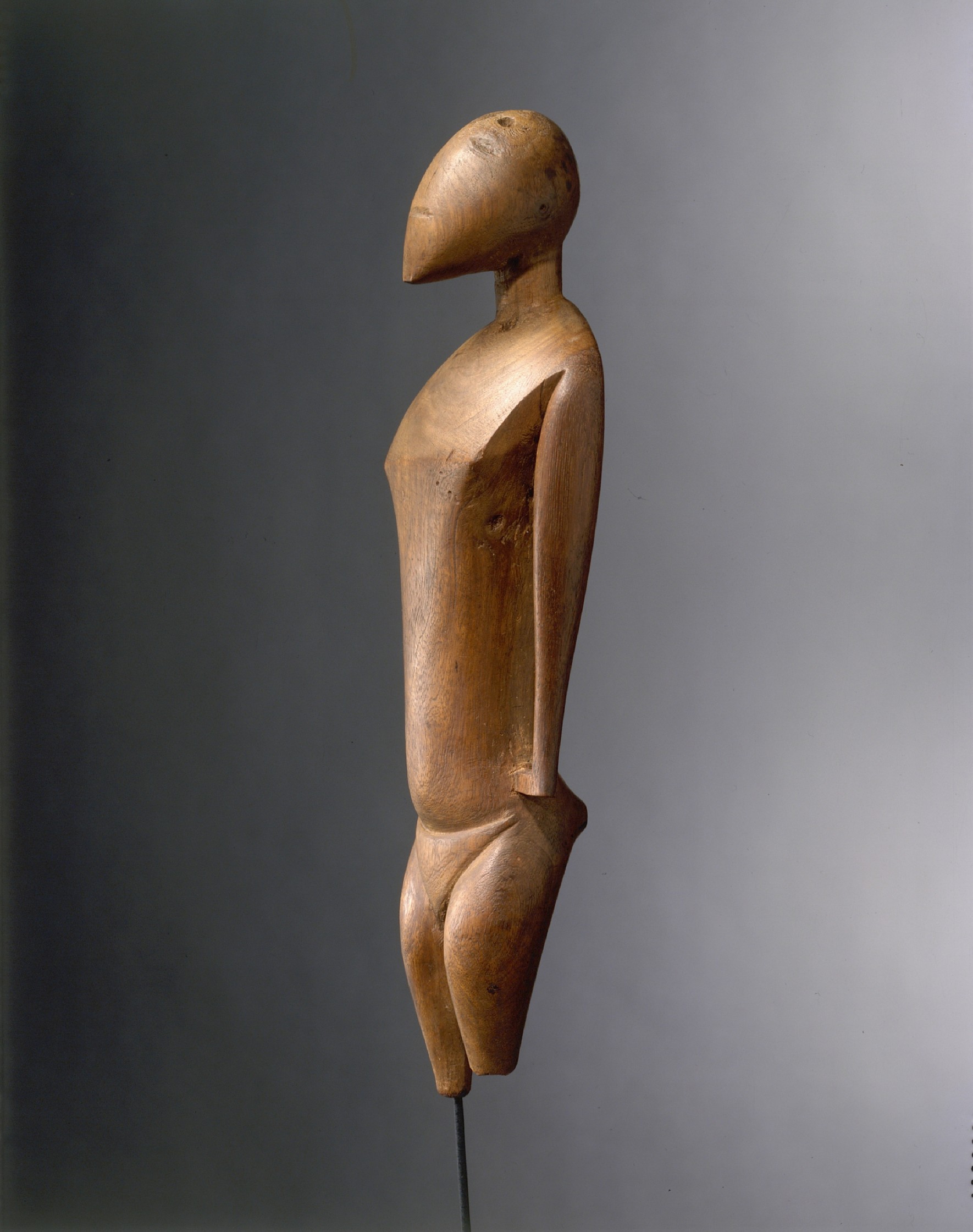
Wooden sculptures from Nukuoro (Micronesia)
by Dr. Fanny Wonu Veys
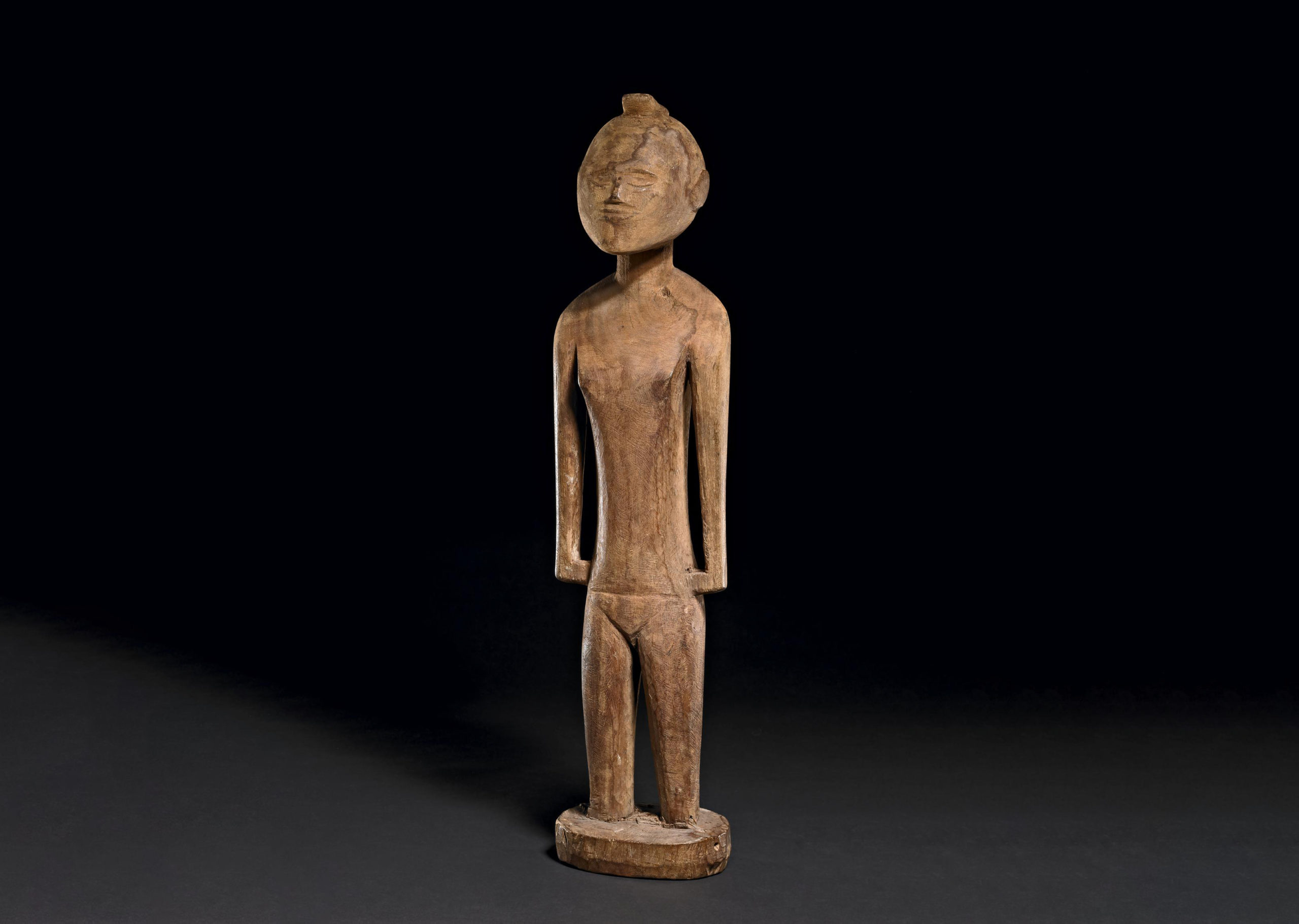
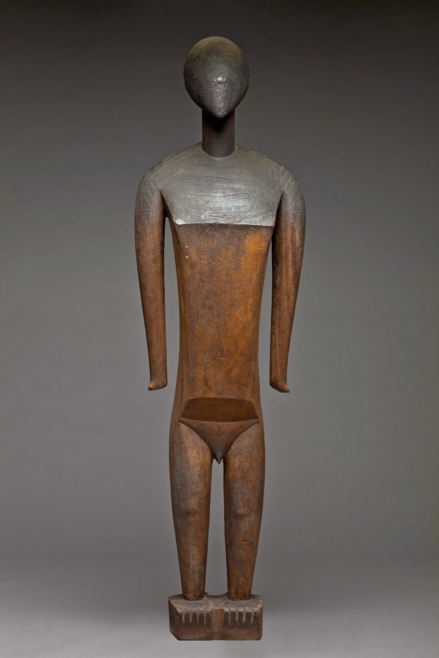
Tino aitu figure, late 18th century, wood, 35 x 10.2 x 7 cm, Nukuoro, Caroline Islands, Micronesia (Musée du quai Branly)
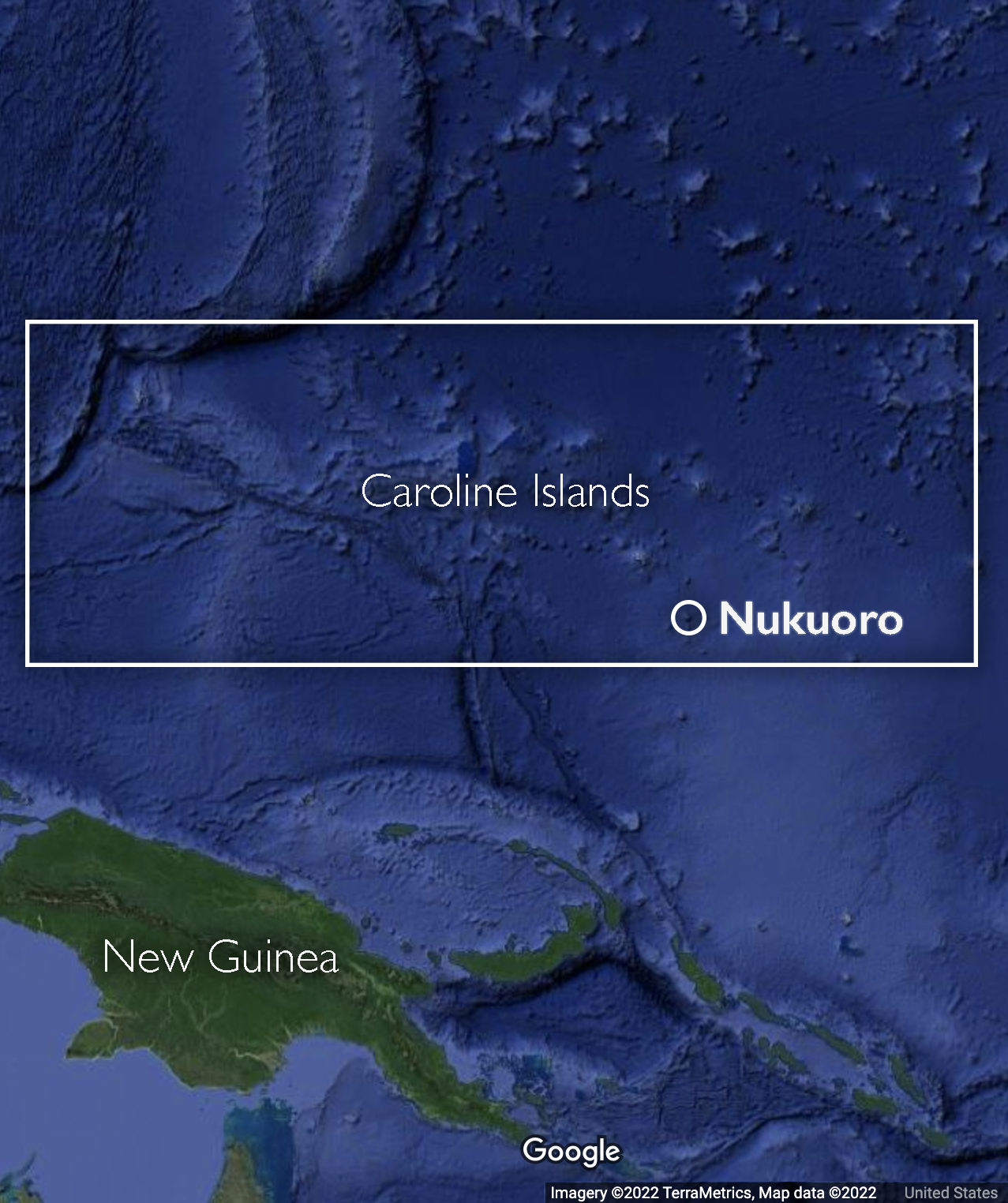
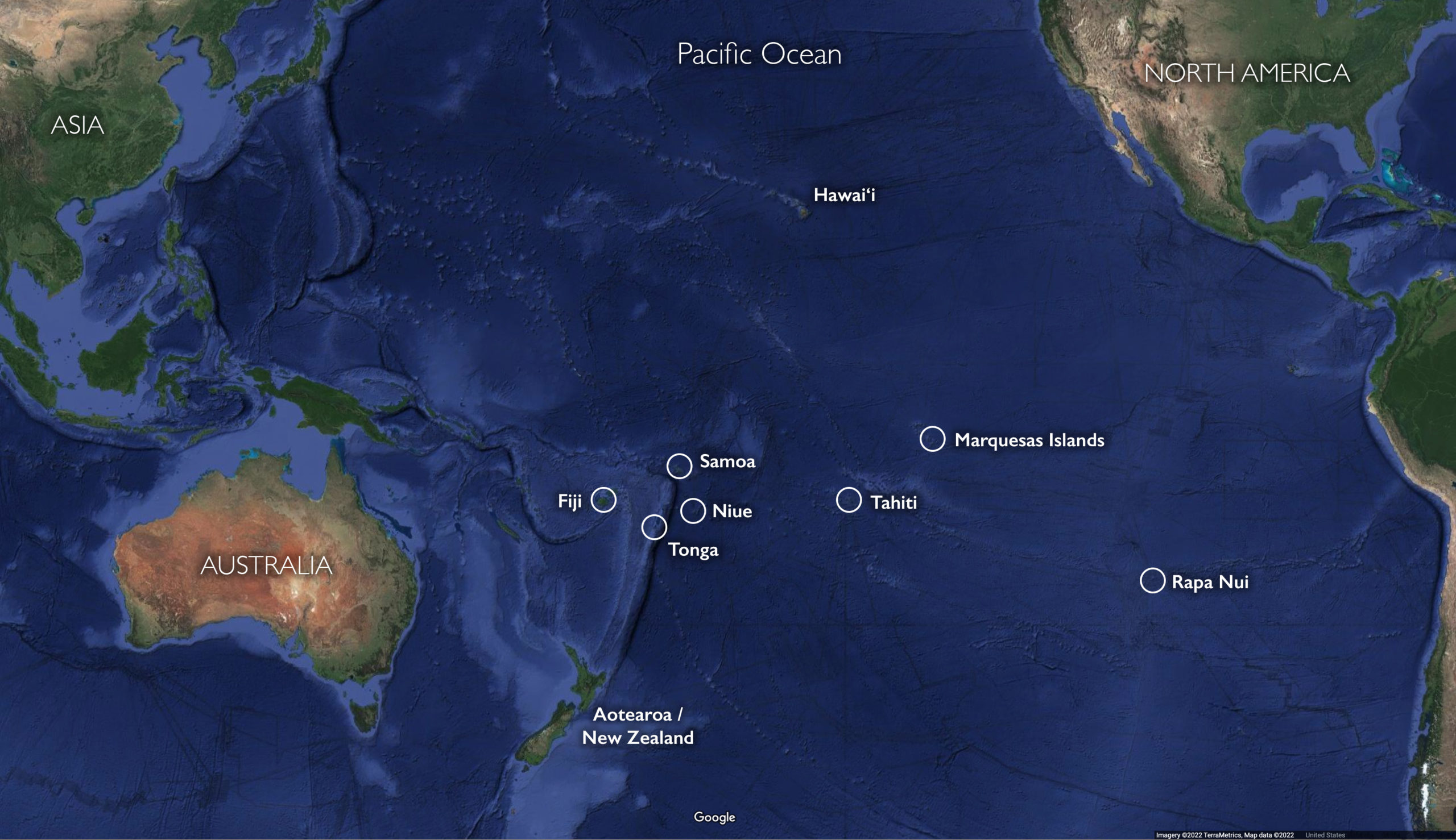
Nukuoro is a small isolated atoll in the archipelago of the Caroline Islands. It is located in Micronesia, a region in the Western Pacific.
Archaeological excavations demonstrate that Nukuoro has been inhabited since at least the eighth century. Oral tradition corroborates these dates relating that people left the Samoan archipelago in two canoes led by their chief Wawe. The canoes first stopped at Nukufetau in Tuvalu and later arrived on the then uninhabited island of Nukuoro. These new Polynesian settlers brought with them ideas of hierarchy and rank, and aesthetic principles such as the carving of stylized human figures. However the new inhabitants also incorporated Micronesian aspects such as the art of navigation, canoe-building and loom-weaving with banana fiber. Because Nukuoro is geographically situated in Micronesia, but is culturally and linguistically essentially Polynesian, it is called a Polynesian Outlier.
Nukuoro Atoll, Micronesia (photo: NASA’s Marshall Space Flight Center, CC BY-NC 2.0)
Encounters with Westerners
The Spanish navigator Juan Bautista Monteverde was the first European to sight the atoll on 18 February 1806 when he was on his way from Manila (in the Philippines) to Lima (in South America). The estimated 400 inhabitants of Nukuoro engaged in barter and exchange with Europeans as early as 1830, as can be attested from the presence of Western metal tools. A trading post was only established in 1870. From the 1850s onwards, American Protestant mission teachers who had been posted in the area visited Nukuoro regularly from the Marshall Islands and from the islands Lukunor, Pohnpei, and Kosrae. However, when the American missionary Thomas Gray arrived in Nukuoro in 1902, to baptize a female chief, he found that a large part of the population was already acquainted with Christianity through a Nukuoroan woman who had lived on Pohnpei. When Gray returned three years later, he found that the local sacred ground (marae) and the large temple had been replaced by a church. By 1913, many of the pre-Christian traditions including dances, songs, and stories were lost. Most of the wooden images had been taken off the island before 1885 and subsequently lost their function.
In 1874, the missionary Edward T. Doane made the first mention of carved wooden figures. It is unclear, however, where this experienced missionary got his information from as he never left his ship, the Morning Star, to go ashore. Two German men, Johann Stanislaus Kubary, who visited the island in 1873 and in 1877 while working for the Godeffroy trading company and its museum, and Carl Jeschke, a ship’s captain who first visited the atoll in 1904 and then regularly between 1910 and 1913, give the most detailed information on the Nukuoroan figures.
Tino aitu figure, before 1830, Nukuoro, Caroline Islands, Micronesia, wood (Museum of Ethnology, Hamburg; photo: Paul Schimweg)
Wooden sculptures
The first Europeans to collect the Nukuoro sculptures found them coarse and clumsy. It is not known whether the breadfruit tree (Artocarpus altilis) images were carved with local adzes equipped with Tridacna shell blades or with Western metal blade tools. The surfaces were smoothed with pumice which was abundantly available on the beach. All the sculptures, ranging in size from 30 cm to 217 cm, have similar proportions: an ovoid head tapering slightly at the chin and a columnar neck. The eyes and nose are either discretely shown as slits or not at all. The shoulders slope downwards and the chest is indicated by a simple line. Some female figures have rudimentary breasts. Some of the sculptures, be they male, female or of indeterminate sex, have a sketchy indication of hands and feet. The buttocks are always flattened and set on a flexed pair of legs.
Deities
Local deities in Nukuoro resided in animals or were represented in stones, pieces of wood, or wooden figurines (tino aitu). Each of the figurines bore the name of a specific male or female deity which was associated with a particular extended family group, a priest and a specific temple. They were placed in temples and decorated with loom-woven bands, fine mats, feathers, paint, or headdresses. The tino aitu occupied a central place in an important religious ceremony that took place towards the month of Mataariki, when the Pleiades are visible in the west at dusk. The rituals marked the beginning of the harvesting of two kinds of taro, breadfruit, arrowroot, banana, sugar cane, pandanus, and coconuts. During the festivities—which could last several weeks—the harvested fruits and food offerings were brought to the wooden sculptures, male and female dances were performed and women were tattooed. Any weathered and rotten statues were also replaced during the ceremony. For the period of these rituals, the sculptures were considered the resting place of a god or a deified ancestor’s spirit.
Early twentieth-century artists
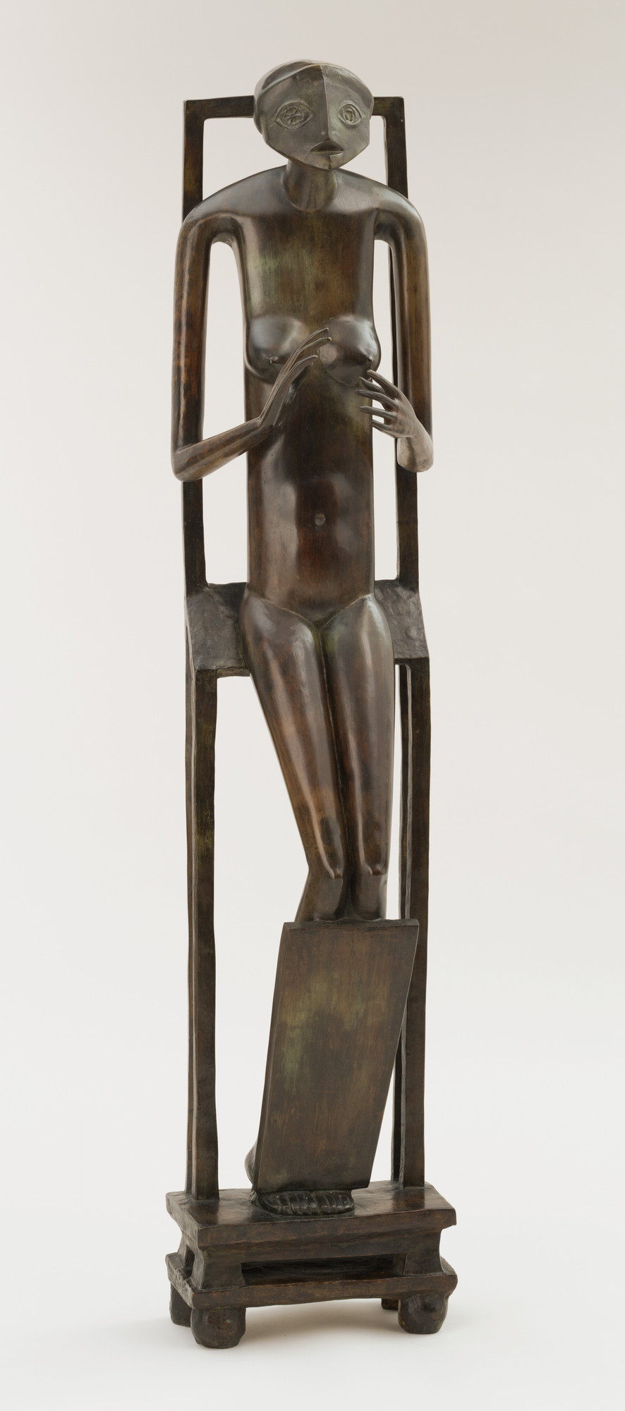
Alberto Giacometti, Hands Holding the Void (Invisible Object), 1934 (cast c. 1954–55), bronze, 152.1 x 32.6 x 25.3 cm (The Museum of Modern Art)
When the Swiss sculptor and painter Alberto Giacometti made his famous sculpture Hands Holding the Void (Invisible Object), he was inspired by a wooden Nukuoro figure he had seen at the Musée de l’Homme in Paris (now in the collection of the Musée du quai Branly). A fellow artist, Henry Moore, considered the Nukuoro image at the British Museum to be one of the highlights in the history of sculpture. Both carvings are part of a small group of thirty-seven sculptures from Nukuoro that arrived in Western museum collections from the 1870s onwards. European artists believed that the highly stylized representation of the human in the Nukuoro figures represented the purest form of art—an art that lay at the origins of mankind.
Nukuoro figures today
Today the sight of even a small Nukuoro figure still makes a big impact on visitors. Scattered across museums and private collections in Europe, North America, and New Zealand, ten figures were brought together for the first time at the Fondation Beyeler in Riehen, near the Swiss city of Basel. This prompted research in these exquisite sculptures, which has been bundled in a book Nukuoro: Sculptures from Micronesia (2013). Nukuoro figures continue to inspire Nukuoroans and Westerners alike as they are copied, and displayed in places ranging from people’s houses to Pacific themed hotel lobbies.
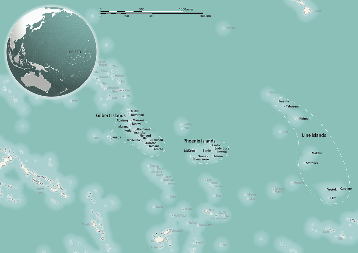
The Republic of Kiribati is a group of thirty-three coral atolls and reefs spread out over 3.5 million square kilometersof the Pacific Ocean. It is located in Micronesia, a region in the Western Pacific. Isolated as an island group, the Islanders use the limited resources they have on hand to produce their material culture.
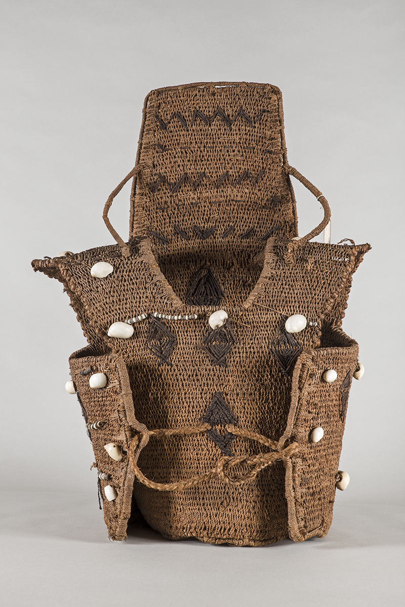
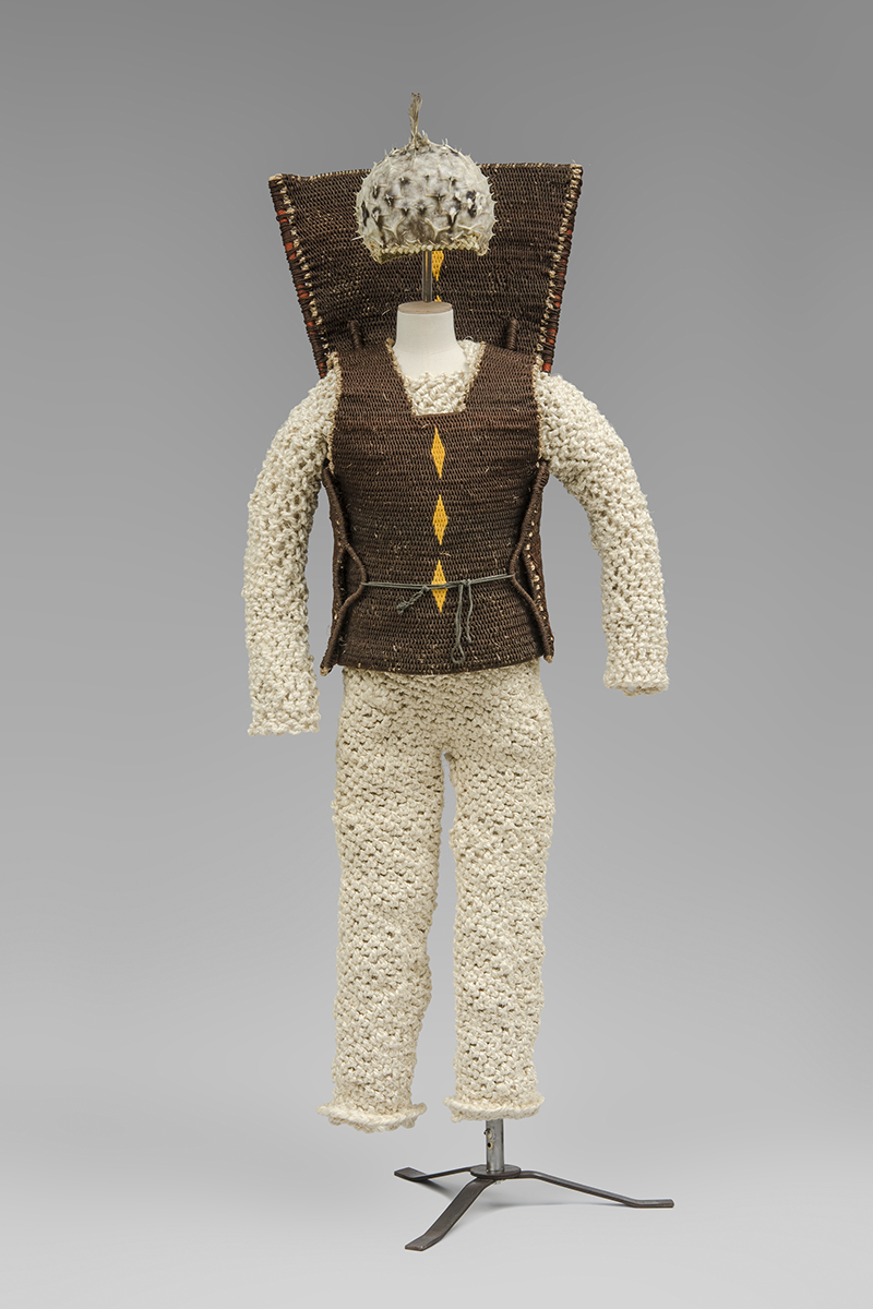
Historically, the I-Kiribati produced extraordinary objects such as suits of armor made from coconut fiber. The armor provided protection from the dangerous shark’s-teeth-edged swords, spears, and daggers carried by island warriors. Each suit is made up of a set of overalls and sleeves made from coconut fiber, with a coconut fiber cuirassworn over the top. The distinctive cuirasses have high backboards to protect from attack from behind, and were often worn with thick belts made from woven coconut fiber or dried ray skin to protect the vital organs. The cuirasses are usually decorated, either with human hair, feathers or shells.
Warriors sometimes wore hand armor also made from coconut fiber, inlaid with shark’s teeth along the knuckles. The warriors would also wear fearsome-looking helmets made of porcupine fish skin, which dried hard in the sun and provided another layer of protection for the head. These helmets would usually have been worn over a coconut fiber or woven pandanus leaf cap.
It is not known where and when this type of armor was developed in the islands, but it has come to stand as uniquely Kiribati, with its influence also spreading to the nearby islands of Nauru and Tuvalu.
Making the armor
Coconut fiber cuirass with struts, decorated with human hair, with porcupine fish helmet (photo: Josh Murfitt, Museum of Archaeology and Anthropology, University of Cambridge)
Coconut fiber string, a material still produced and used today, is the main material used for the armor, chosen not just for its availability but also its strength and flexibility. The fibers come from the husk of the coconut, found between the inner shell and the outer skin. These fibers are soaked in the water of the lagoon for two to three months, then rinsed and dried. Several fibers are rolled into small strands, which are then rolled together to create long cords.
Many of the cuirasses feature lozenge-shaped or geometric designs made from human hair; sometimes these diamond shapes are developed to become fish or turtles. Hair is something quite special and precious, but is also easily accessible. The woven diamond motif seen here is most likely women’s hair. Often combined with coconut fiber, hair was also used for binding the shark’s teeth to swords, and is still used today in dance belts.
The process of making the armor would have been associated with a powerful ritual, instilling in the armor the power and strength of the raw materials used to make it. The warriors would also go through a ritual before going into battle.
Wearing the armor
The armor would have been worn in conflict resolution between individuals or groups of people. Generally the fighting would have been related to land claims or retribution. In all contests, the aim was to wound your adversary, not to kill them, as a wound would be adequate retribution. If someone did die during the battle then payment to the wronged party would need to have been made through the gift of land.
Warriors in armor would have carried a shark’s-tooth spear tipped with a stingray barb. They would never have fought alone, but would have been surrounded by a number of people who were not wearing full armor, carrying branched spears, clubs, and small daggers. In cases of inter-village or island warfare, each side would march in three groups, with the main warriors in the center surrounded by their supporting troops. When the two sides met, the overall outcome would depend on the result of individual challenges made by the warriors.
Pedro Fernandes de Queiros was the first European to sight the Gilbert Islands (the main group of islands in what is now the Republic of Kiribati) in 1606. The British explorers John Byron, Thomas Gilbert, and John Marshall all passed through the sixteen atolls without landing between 1764 and 1788. The islands were named the Gilbert Islands by the Russian general Adam Johann von Krusenstern, who also crossed without landing in 1820. The French captain Louis Duperrey then mapped the islands fully in 1824.
There are records of Kiribati armor in European collections as early as 1824 [1], but there are no known descriptions of it in historical records until 1844, when the United States Exploring Expedition published an account of their arrival on Tabiteuea (an atoll in the Gilbert Islands). Whalers and blackbirders from Australia, the United States, and Europe also visited the islands during the 1800s, often settling there for periods and taking home the armor they acquired.
The rapid decline in the production of this type of armor is generally attributed to the influence of missionaries, who first arrived from France in 1888, and the British, who arrived 1892, both of whom introduced new laws and attempted to pacify the islands. I-Kiribati do not commonly make anything that is not needed; a lack of further need for the armor is likely one of the reasons that these objects were offered to tourists, government officials, explorers, whalers, and other visitors, and why so many are now found in museums across the world.
Kiribati armor made by Kaetaeta Watson, Chris Charteris, and Lizzy Leckie, 2016 (2017.14.1-3, Copyright Museum of Archaeology and Anthropology, University of Cambridge)
Kiribati armor today
Small decorative shark’s-teeth daggers are still produced for tourists. However, suits of armor are no longer made for use. Today, historic suits of armor can be found in Kiribati on exhibition at Te Umwanibong, the Kiribati Museum and Culture Centre on Tarawa atoll, but it is not known that any others exist in the islands.
In 2016, the Pacific Presences project, based at the Museum of Archaeology and Anthropology, University of Cambridge commissioned New Zealand-based artists Chris Charteris, Lizzy Leckie, and Kaetaeta Watson to make a new suit of armor. This armor, named Kautan Rabakau, is now part of the permanent collection of the Museum of Archaeology and Anthropology.
Kiribati became an independent nation in 1979, and since then the image of the “warrior” has re-emerged, and can be seen used on clothing and as mascots for sports teams—a symbol of strength and pride. It has also been repurposed by the Mormon faith Moroni High School in Tarawa, who see themselves as fighting both a spiritual and physical war in the modern world.
While the battles that necessitated this armor are over, Kiribati now faces the new challenges of climate change and the effects of westernization on traditional life and culture.
The research for this entry was produced during the European Research Council funded project: ‘Pacific Presences: Oceanic Art and European Museums’, under the European Union’s Seventh Framework Programme (FP7/2007-2013) / ERC grant agreement n° [324146]11.
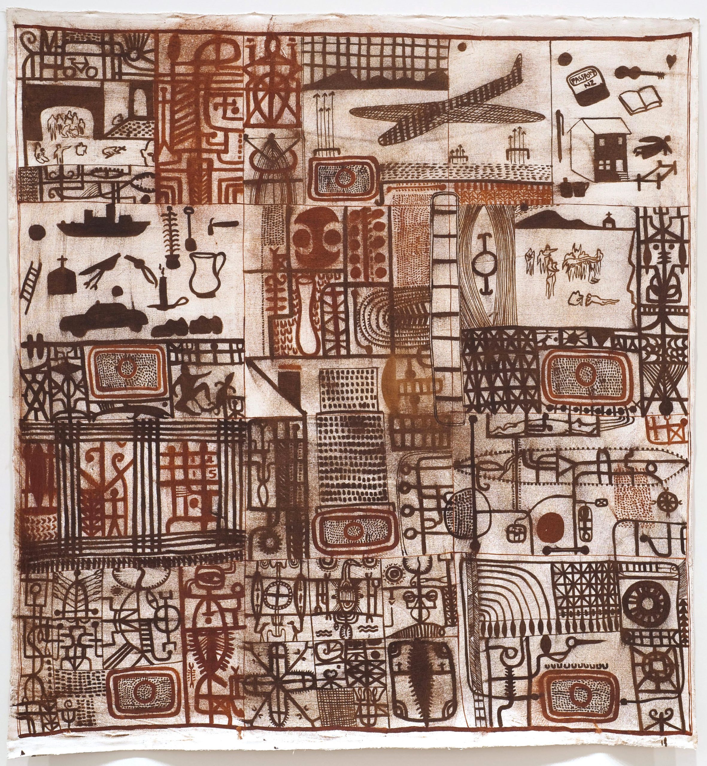
Polynesia is one of the three major categories created by Westerners to refer to the islands of the South Pacific. Polynesia means literally “many islands.” Knowledge of ancient Polynesian culture derives from ethnographic journals, missionary records, archaeology, linguistics, and oral traditions. Polynesians represent vital art-producing cultures in the present day.
Each Polynesian culture is unique, yet the peoples share some common traits. Polynesians share common origins as Austronesian speakers (Austronesian is a family of languages). The first known inhabitants of this region are called the Lapita peoples. Polynesians were distinguished by long-distance navigation skills and two-way voyages on outrigger canoes. Native social structures were typically organized around highly developed aristocracies, and beliefs in primo-geniture (priority of the first-born). At the top of the social structure were divinely sanctioned chiefs, nobility, and priests. Artists were part of a priestly class, followed in rank by warriors and commoners.
Polynesian cultures value genealogical depth, tracing one’s lineage back to the gods. Oral traditions recorded the importance of genealogical distinction, or recollections of the accomplishments of the ancestors. Cultures held firm to the belief in mana, a supernatural power associated with high rank, divinity, maintenance of social order and social reproduction, as well as an abundance of water and fertility of the land. Mana was held to be so powerful that rules or taboos were necessary to regulate it in ritual and society. For example, an uninitiated person of low rank would never enter in a sacred enclosure without risking death. Mana was believed to be concentrated in certain parts of the body and could accumulate in objects, such as hair, bones, rocks, whale’s teeth, and textiles.
Gender roles in the arts
Gender roles were clearly defined in traditional Polynesian societies. Gender played a major role, dictating women’s access to training, tools, and materials in the arts. For example, men’s arts were often made of hard materials, such as wood, stone, or bone and men’s arts were traditionally associated with the sacred realm of rites and ritual.
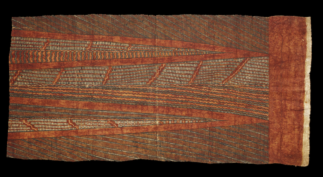
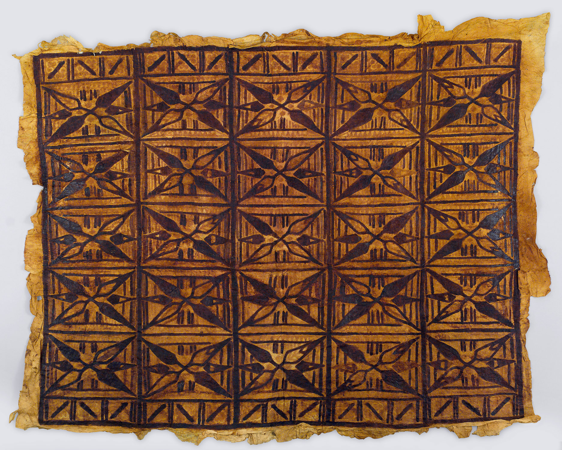
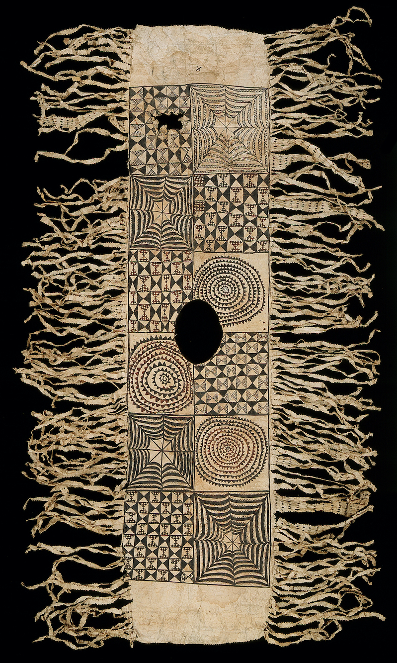
Hawaiian kapa (barkcloth), 1770s, 64.5 x 129 cm (Te Papa, New Zealand)
Women’s arts historically utilized soft materials, particularly fibers used to make mats and bark cloth. Women’s arts included ephemeral materials such as flowers and leaves. Cloth made of bark is generically known as tapa across Polynesia, although terminology, decorations, dyes, and designs vary through out the islands.
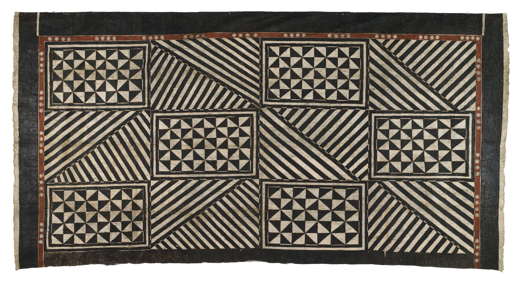
Barkcloth Panel (Siapo), Samoa, early 20th century, 139.7 x 114.3 cm (The Metropolitan Museum of Art, New York)
Bark cloth as women’s art
Generally, to make bark cloth, a woman would harvest the inner bark of the paper mulberry (a flowering tree). The inner bark is then pounded flat, with a wooden beater or ike, on an anvil, usually made of wood. In Eastern Polynesia (Hawaiʻi), bark cloth was created with a felting technique and designs were pounded into the cloth with a carved beater. In Samoa, designs were sometimes stained or rubbed on with wooden or fiber design tablets. In Hawaiʻi patterns could be applied with stamps made out of bamboo, whereas stencils of banana leaves or other suitable materials were used in Fiji. Bark cloth can also be undecorated, hand decorated, or smoked as is seen in Fiji. Design illustrations involved geometric motifs in an overall ordered and abstract patterns.
Masi (tapa cloth), likely used as a room divider, Fiji, date unknown, 300 x 428 cm (Te Papa, New Zealand)
The most important traditional uses for tapa were for clothing, bedding and wall hangings. Textiles were often specially prepared and decorated for people of rank. Tapa was ceremonially displayed on special occasions, such as birthdays and weddings. In sacred contexts, tapa was used to wrap images of deities. Even today, at times of death, bark cloth may be integral part of funeral and burial rites.
In Polynesia, textiles are considered women’s wealth. In social settings, bark cloth and mats participate in reciprocity patterns of cultural exchange. Women may present textiles as offerings in exchange for work, food, or to mark special occasions. For example, in contemporary contexts in Tonga, huge lengths of bark cloth are publicly displayed and ceremoniously exchanged to mark special occasions. Today, western fabric has also been assimilated into exchange practices. In rare instances, textiles may even accumulate their own histories of ownership and exchange.
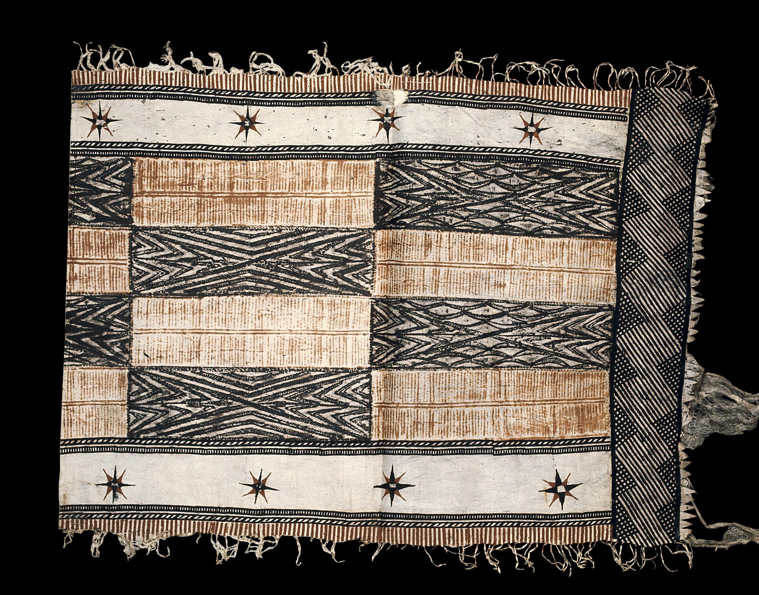
Hiapo (tapa), Niue, c. 1850–1900, Tapa or bark cloth, freehand painting (Aukland War Memorial Museum)
Hiapo: Niuean bark cloth
Niue is an island country south of Samoa. Little is known about early Niuean bark cloth or hiapo, as represented by the illustration depicted below. Niueans’ first contact with the west was the arrival of Captain Cook, who reached the island in 1774. No visitors followed for decades, not until 1830, with the arrival of the London Missionary Society. The missionaries brought with them Samoan missionaries, who are believed to have introduced bark cloth to Niue from Samoa. The earliest examples of hiapo were collected by missionaries and date to the second half of the nineteenth century. Niuean ponchos (tiputa) collected during this era, are based on a style that had previously been introduced to Samoa and Tahiti. It is probable, however, that Niueans had a native tradition of bark cloth prior to contact with the West.
iputa (Poncho), 19th century, Niue (Te Papa, New Zealand, CC BY-NC-ND 4.0)
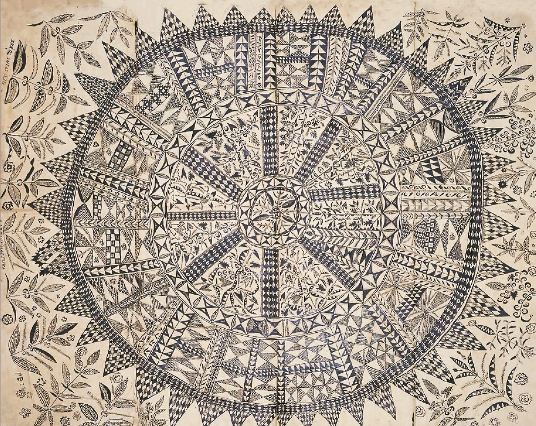
In the 1880s, a distinctive style of hiapo decorations emerged that incorporated fine lines and new motifs. Hiapo from this period are illustrated with complicated and detailed geometric designs. The patterns were composed of spirals, concentric circles, squares, triangles, and diminishing motifs (the design motifs decrease in size from the border to the center of the textile). Niueans created naturalistic motifs and were the first Polynesians to introduce depictions of human figures into their bark cloth. Some hiapo examples include writing, usually names, along the edges of the overall design.
Niuean hiapo stopped being produced in the late nineteenth century. Today, the art form has a unique place in history and serves to inspire contemporary Polynesian artists. A well-known example is Niuean artist John Pule, who creates art of mixed media inspired by traditional hiapo design.
Tapa today
Tapa traditions were regionally unique and historically widespread throughout the Polynesian Islands. Eastern Polynesia did not experience a continuous tradition of tapa production, however, the art form is still produced today, particularly in the Hawaiian and the Marquesas Islands. In contrast, Western Polynesia has experienced a continuous tradition of tapa production. Today, bark cloth participates in native patterns of celebration, reciprocity and exchange, as well as in new cultural contexts where it inspires new audiences, artists, and art forms.
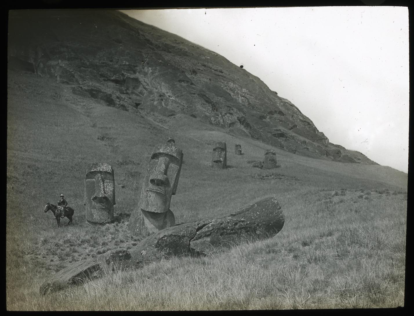
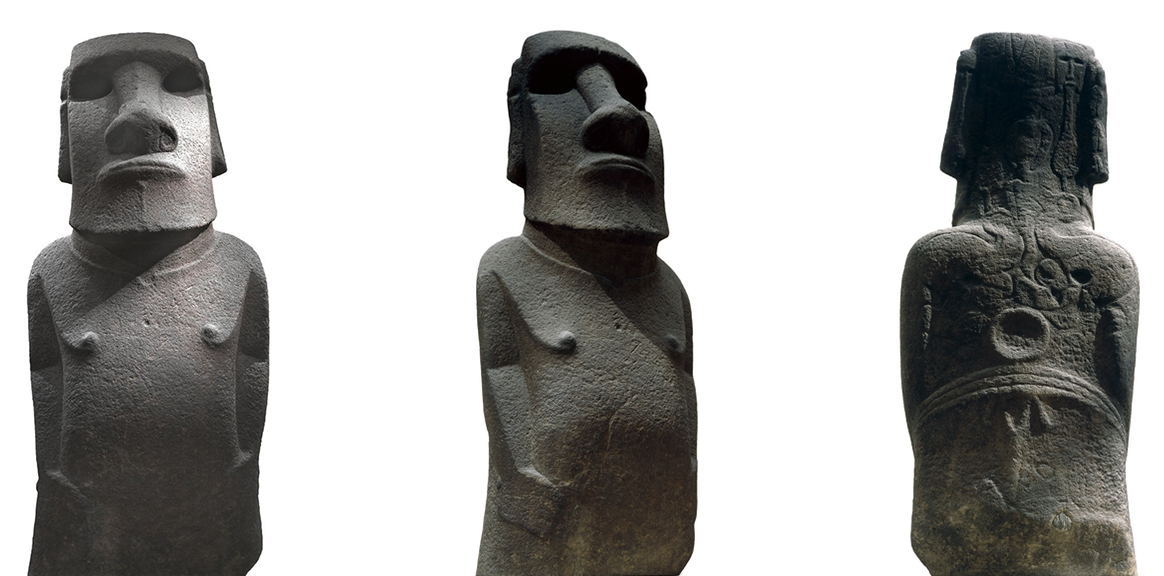
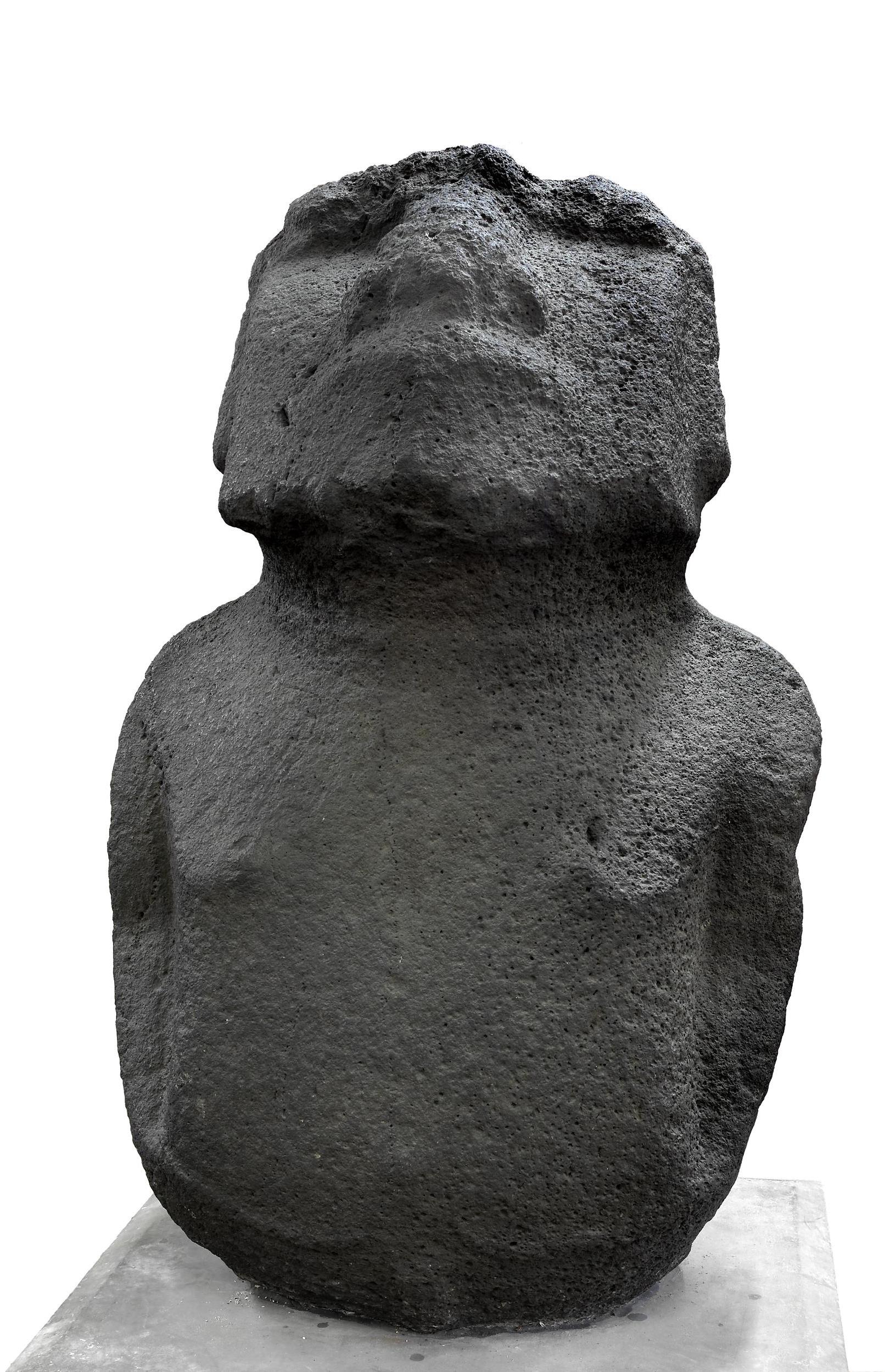
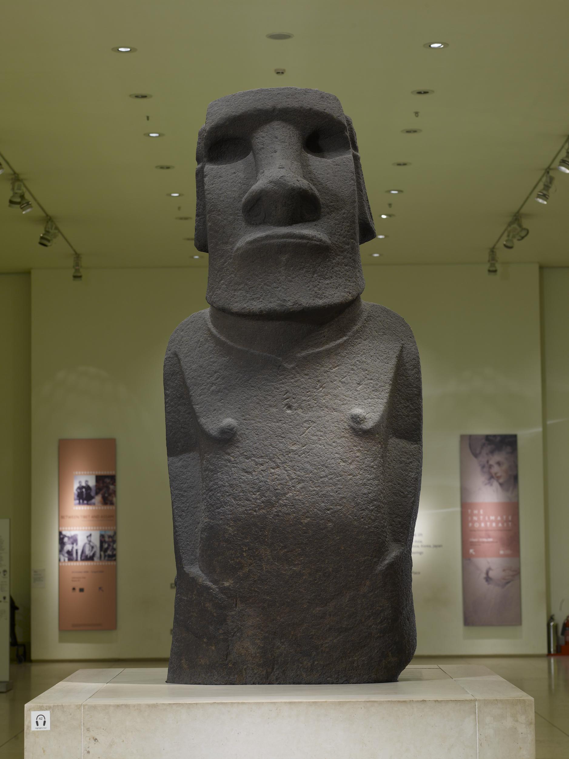
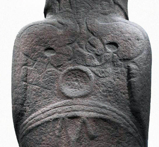
Easter Island is famous for its stone statues of human figures, known as moai (meaning “statue”). The island is known to its inhabitants as Rapa Nui. The moai were probably carved to commemorate important ancestors and were made from around 1000 C.E. until the second half of the seventeenth century. Over a few hundred years the inhabitants of this remote island quarried, carved and erected around 887 moai. The size and complexity of the moai increased over time, and it is believed that Hoa Hakananai’a dates to around 1200 C.E. It is one of only fourteen moai made from basalt, the rest are carved from the island’s softer volcanic tuff. With the adoption of Christianity in the 1860s, the remaining standing moai were toppled.
This example was probably first displayed outside on a stone platform (ahu) on the sacred site of Orongo, before being moved into a stone house at the ritual center of Orongo. It would have stood with giant stone companions, their backs to the sea, keeping watch over the island. Its eyes sockets were originally inlaid with red stone and coral and the sculpture was painted with red and white designs, which were washed off when it was rafted to the ship, to be taken to Europe in 1869. It was collected by the crew of the English ship HMS Topaze, under the command of Richard Ashmore Powell, on their visit to Easter Island in 1868 to carry out surveying work. Islanders helped the crew to move the statue, which has been estimated to weigh around four tons. It was moved to the beach and then taken to the Topaze by raft.
The crew recorded the islanders’ name for the statue, which is thought to mean “stolen or hidden friend.” They also acquired another, smaller basalt statue, known as Moai Hava, which is also in the collections of the British Museum.
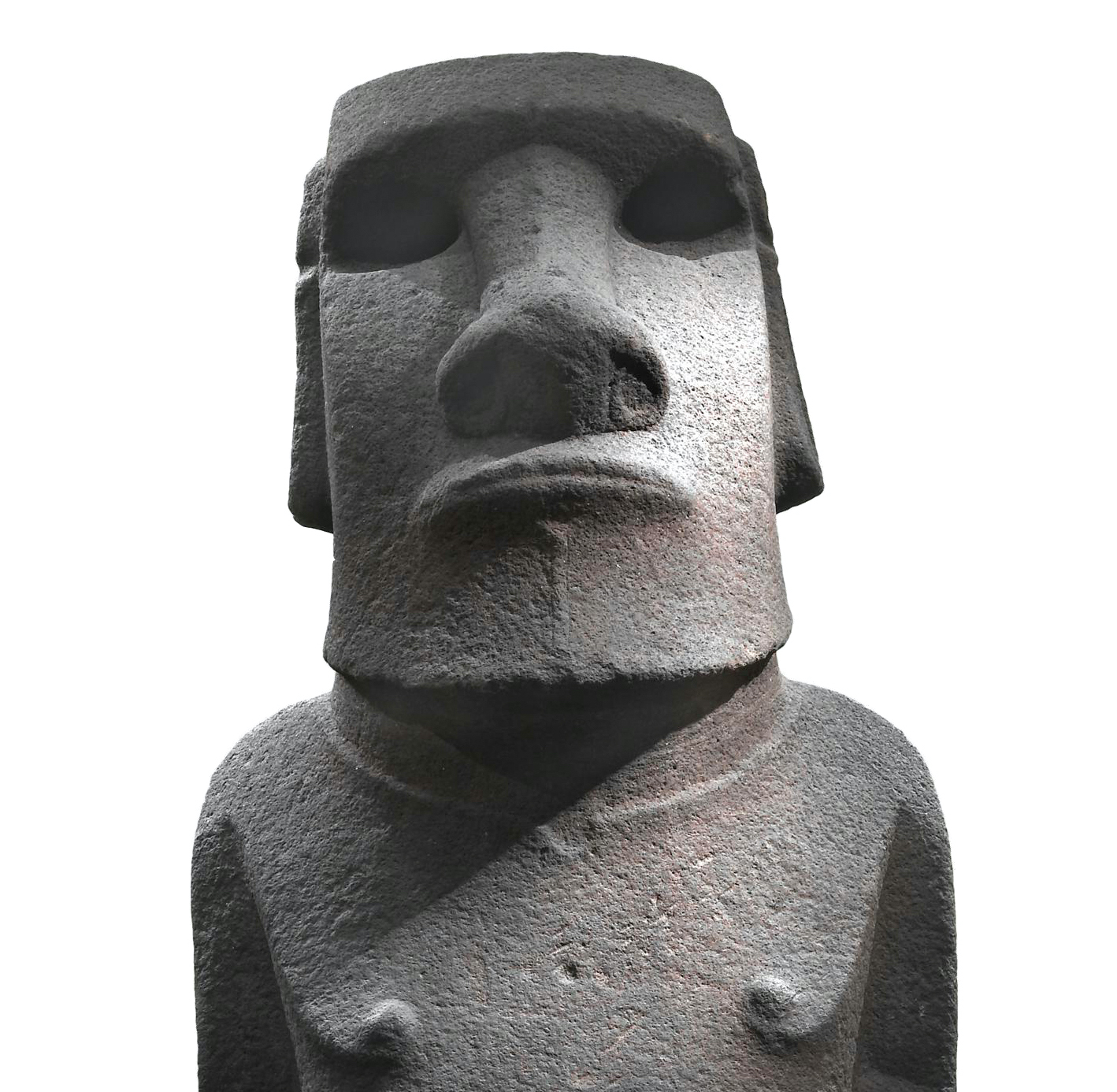
Hoa Hakananai’a is similar in appearance to a number of Easter Island moai. It has a heavy eyebrow ridge, elongated ears and oval nostrils. The clavicle is emphasized, and the nipples protrude. The arms are thin and lie tightly against the body; the hands are hardly indicated.
In the British Museum, the figure is set on a stone platform just over a meter high so that it towers above the visitor. It is carved out of dark grey basalt—a hard, dense, fine-grained volcanic rock. The surface of the rock is rough and pitted, and pinpricks of light sparkle as tiny crystals in the rock glint. Basalt is difficult to carve and unforgiving of errors. The sculpture was probably commissioned by a high status individual.
Hoa Hakananai’a’s head is slightly tilted back, as if scanning a distant horizon. He has a prominent eyebrow ridge shadowing the empty sockets of his eyes. The nose is long and straight, ending in large oval nostrils. The thin lips are set into a downward curve, giving the face a stern, uncompromising expression. A faint vertical line in low relief runs from the centre of the mouth to the chin. The jawline is well defined and massive, and the ears are long, beginning at the top of the head and ending with pendulous lobes.
The figure’s collarbone is emphasized by a curved indentation, and his chest is defined by carved lines that run downwards from the top of his arms and curve upwards onto the breast to end in the small protruding bumps of his nipples. The arms are held close against the side of the body, the hands rudimentary, carved in low relief.
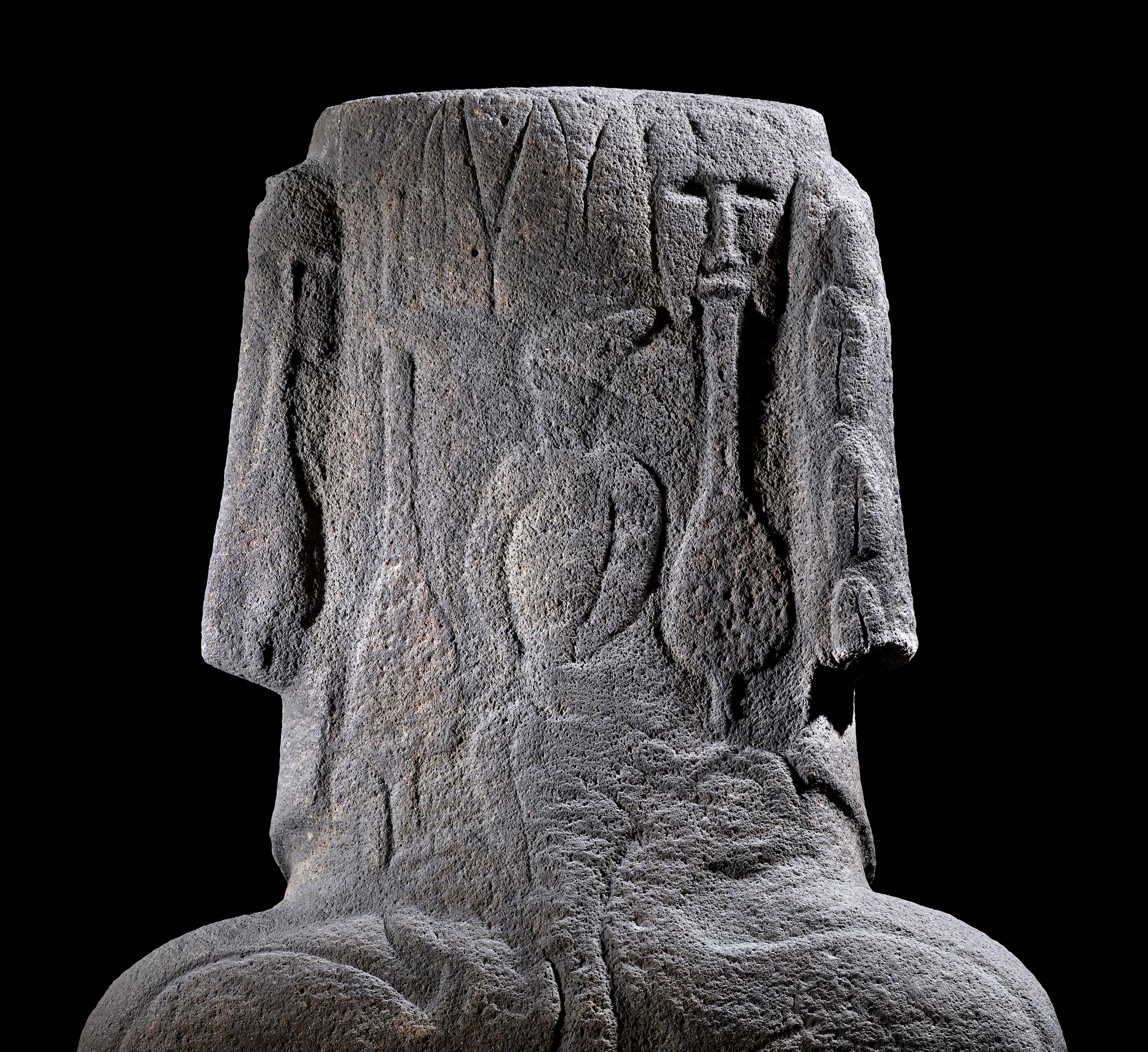
The figure’s back is covered with ceremonial designs believed to have been added at a later date, some carved in low relief, others incised. These show images relating to the island’s birdman cult, which developed after about 1400 C.E. The key birdman cult ritual was an annual trial of strength and endurance, in which the chiefs and their followers competed. The victorious chief then represented the creator god, Makemake, for the following year.
Carved on the upper back and shoulders are two birdmen, facing each other. These have human hands and feet, and the head of a frigate bird. In the centre of the head is the carving of a small fledgling bird with an open beak. This is flanked by carvings of ceremonial dance paddles known as ‘ao, with faces carved into them. On the left ear is another ‘ao, and running from top to bottom of the right ear are four shapes like inverted ‘V’s representing the female vulva. These carvings are believed to have been added at a later date.
Collapse
Around 1500 C.E. the practice of constructing moai peaked, and from around 1600 C.E. statues began to be toppled, sporadically. The island’s fragile ecosystem had been pushed beyond what was sustainable. Over time only sea birds remained, nesting on safer offshore rocks and islands. As these changes occurred, so too did the Rapanui religion alter—to the birdman religion.
This sculpture bears witness to the loss of confidence in the efficacy of the ancestors after the deforestation and ecological collapse, and most recently a theory concerning the introduction of rats, which may have ultimately led to famine and conflict. After 1838 at a time of social collapse following European intervention, the remaining standing moai were toppled.
Source: Dr. Jenny Newell and Beth Harris, “Rapa Nui (Easter Island) Moai,” in Smarthistory, June 24, 2022, accessed July 31, 2024, https://smarthistory.org/easter-island-moai/.
Voyage to the moai of Rapa Nui (Easter Island) (Polynesia)
by Dr. Wayne Ngata and Dr. Steven Zucker
Moai of Rapa Nui (Easter Island), Waka Tapu, and the reclaiming of cultural heritage
Source: Dr. Wayne Ngata and Dr. Steven Zucker, “Voyage to the moai of Rapa Nui (Easter Island),” in Smarthistory, August 10, 2017, accessed July 31, 2024, https://smarthistory.org/moai-waka/.