Oceania is a realm like no other. Nowhere else in the world can one find some of the unique wildlife that is found in this realm, and no other region is as isolated. Oceania is the only world region not connected by land to another region. This is a region of the world at a crossroads where the effects of global changes in climate and pollution could have profound effects. The region of Oceania includes Australia, the realms of the Pacific Islands, and the polar regions of the Arctic and the Antarctic. While some regions share a distinct cultural or colonial history and others share a common physical landscape, the region of Oceania is connected more by its isolation than by a shared physiography or human experience.
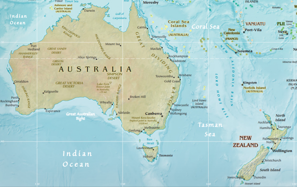
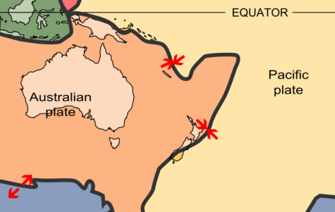
Australia dominates the region in terms of size, economics, and population. The country has the unique designation of being both a sovereign state and a continent. Often, Australia and New Zealand are considered a single region, but while the two countries share cultural and historical similarities, their physical landscapes are quite different. Australia lies in the middle of its own tectonic plate making it relatively geologically stable. Australia has no active volcanoes and has had only a small number of large earthquakes. Its tectonic position also limits its relief and much of the continent is relatively flat. An exception to this is the Great Dividing Range which runs along the coast of Eastern Australia. This series of mountain ranges affects Australia’s climate by providing orographic rainfall along the coast and divides the core population center of Australia from the rest of the continent.
Physical Map of Australia and New Zealand (CIA World Factbook, Public Domain)
The other key geographic feature of Australia is its vast interior known as the Outback. This remote area of extensive grassland pastures supports one of the world’s largest sheep and cattle industries. However, the ecosystem of the Outback is quite fragile. With limited precipitation and vegetation, overgrazing puts the region at risk for desertification. In addition, although this region was the center of population for Australia’s indigenous groups, ranching in the Outback has created issues of land ownership.
One of the most well-known features of Australia’s geography lies just off coast: the Great Barrier Reef. This massive underwater reef is the world’s largest coral structure and stretches over 2,300 kilometers (1,400 miles). However, warming ocean temperatures and pollution have been a significant environmental threat to the Great Barrier Reef in recent years.Unlike its geologically stable neighbor, New Zealand is situated at the intersection of the Pacific Plate and the Australian Plate. Its two large, mountainous islands and numerous small islands are prone to both earthquakes and volcanoes. New Zealand is younger than Australia geologically and has a far more varied topography. On New Zealand’s North Island alone, you could spend the morning surfing on a sandy beach, the afternoon picnicking in the rolling green hills where the fictional city of Hobbiton was filmed, and the evening skiing on an active volcano, Mount Ruapehu. New Zealand’s South Island is home to a number of stunning fiords, more commonly found in Scandinavia where they are spelled fjord.
Map of the Tectonic Plates of Oceania (United States Geological Survey, Public Domain)
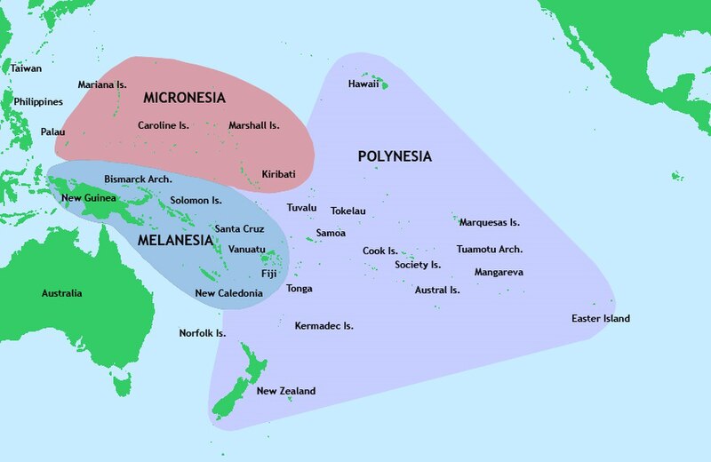
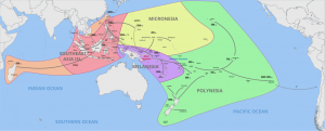
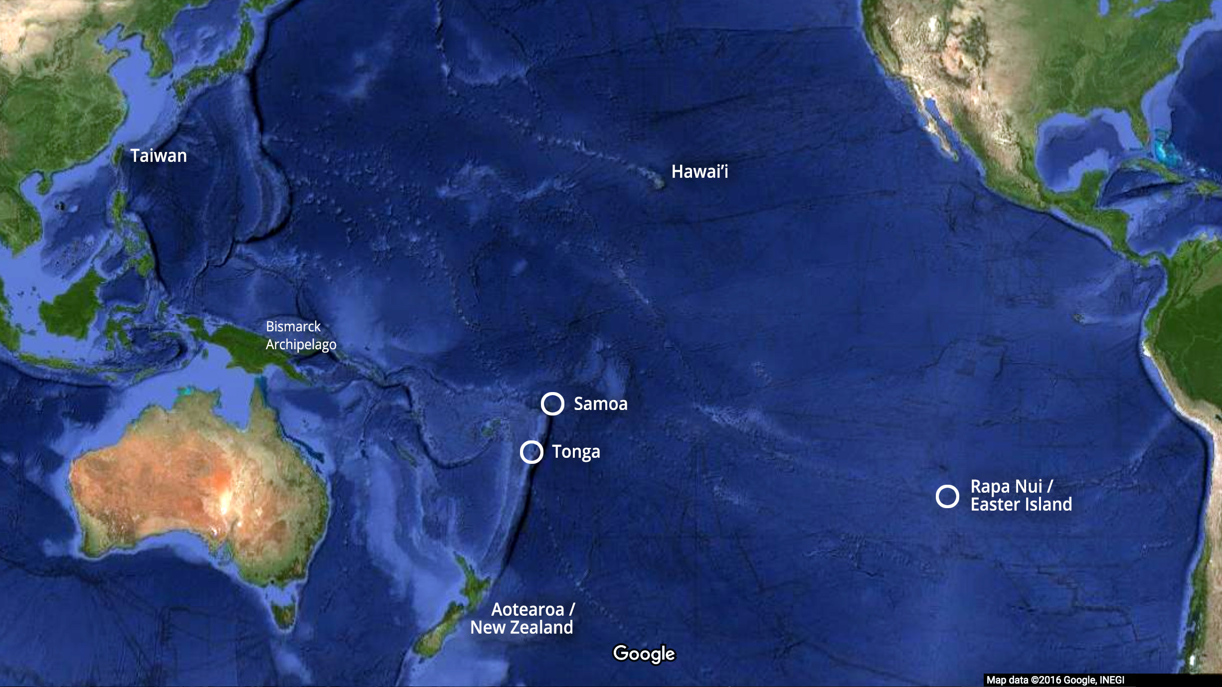
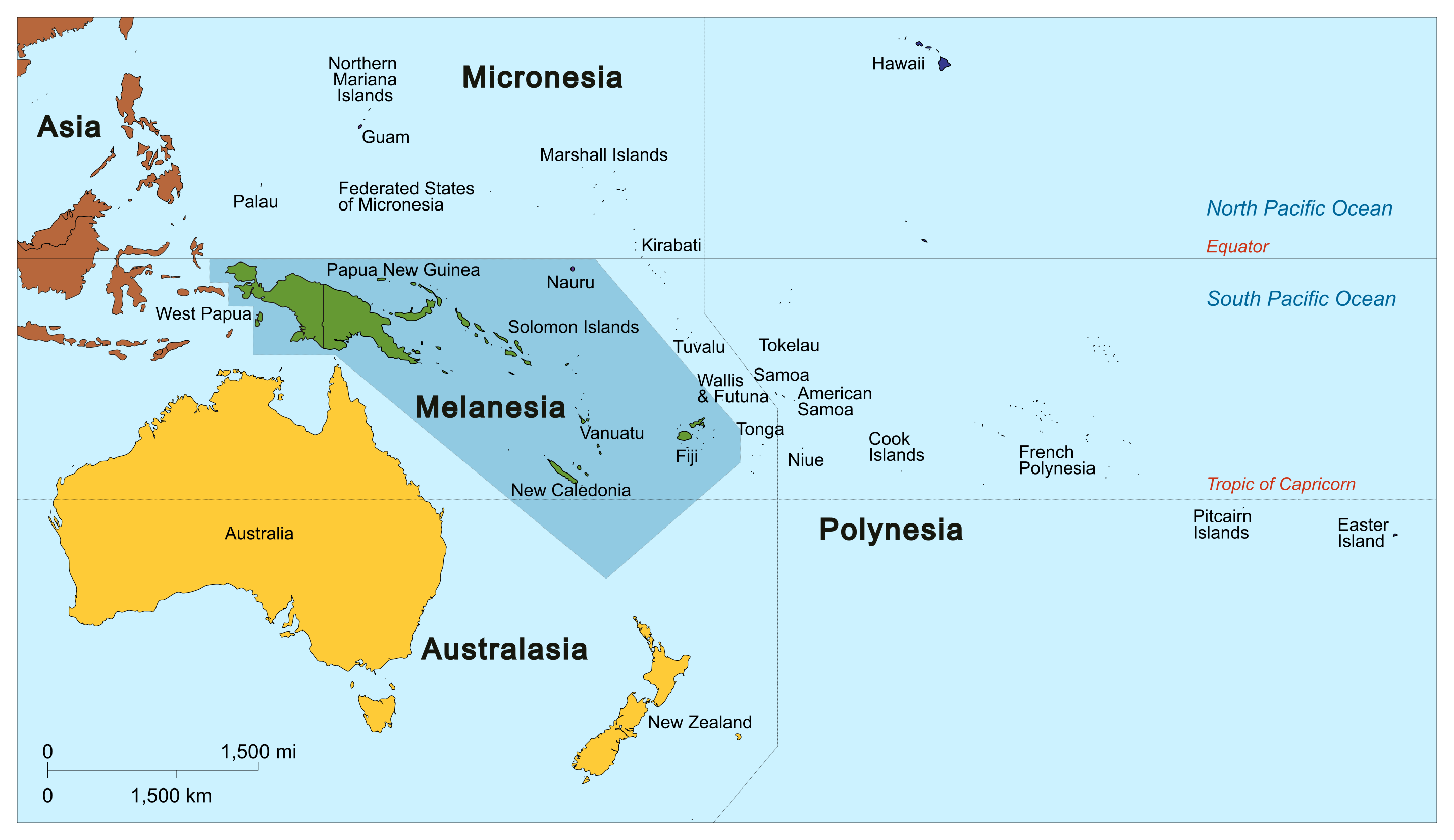
The islands of the Pacific to the north and east of Australia and New Zealand are divided into three regions. New Zealand is part of the islands of Polynesia, from the prefix “poly” meaning “many.” Polynesia is a large, triangular region stretching from New Zealand to Easter Island to the Hawaiian and Midway Islands. West of Polynesia and to the northeast of Australia are the islands of Melanesia, including New Guinea, the Solomon Islands, and Fiji. Europeans called the region “Melanesia” from the Greek prefix melan- meaning “black,” referring to the darker skin they believed characterized the people of this realm. North of Melanesia are the tiny islands of Micronesia, from the prefix “micro” meaning “small.” There are over 2,000 islands in Micronesia.
Map of Australia and the Pacific (Map by User:Kahuroa, Wikimedia Commons, Public Domain)
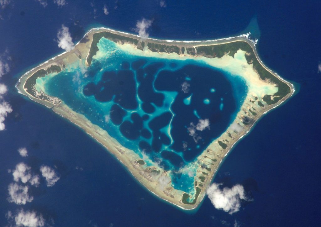
The islands of the Pacific can be divided into two groups based on their physical characteristics. The high islands like Hawaii are volcanic, meaning they were formed from volcanoes, and thus have a relatively high relief. This high relief and volcanic soils enables the high islands to have fertile soil and ample rainfall, which in turn supports a diverse agricultural system and relatively large populations.In contrast, the low islands of the Pacific are comprised mostly of coral and, as their name implies, are generally low in elevation. Most of the islands in the Pacific, particularly in Micronesia, are low islands. These islands may only rise a few feet above the water and their dry, sandy soil makes farming difficult. Fresh water is often in short supply in the low islands. As a result, these islands typically have much smaller populations. The relatively large coral island that comprises the country of Niue, for example, rises to a maximum 60 meters (less than 200 feet). The low elevation of these islands make them vulnerable to natural disasters, such as tropical cyclones, and to changes in sea elevation due to rising global temperatures. In the country of Tuvalu, an island chain located between Hawaii and Australia, the highest point is a mere 4.6 meters (15 feet) above sea level and the island has sustained severe damage from cyclones during its history.A number of low islands of in the Pacific form atolls, ring-shaped chains of coral islands surrounding a central lagoon. Typically, the lagoon is actually a volcanic crater which has eroded beneath the water. Most of the world’s atolls are found in the Pacific Ocean and their land areas are generally quite small.
Satellite Photo of the Atafu Atoll in Tokelau (NASA Johnson Space Center, Public Domain)
In general, the islands of the Pacific have warm, tropical climates with little seasonal extremes in temperature. Some islands experience seasonal, primarily orographic rainfall. These relatively warm temperatures help support tourism throughout the region. Throughout New Zealand and the core area of Australia, east of the Great Dividing Range, is primarily a maritime climate. This climate zone features cool summers and winters with few extremes in temperature or in rainfall.Adapted from Caitlin Finlayson, World Regional Geography, OpenStax, Shared under a CC-by-NC-SA license.
The Patterns of Human Settlement in Australia and the Pacific
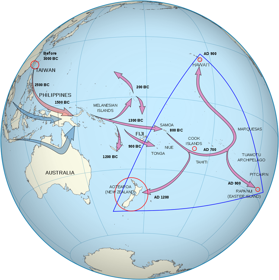
Much of the physical landscape of Oceania has been directly shaped by human activity and settlement. Although Australia today is known for its origin as a British prison colony, the continent was inhabited long before Europeans arrived. The indigenous people of Australia are known as Aborigines and comprise a number of different ethnolinguistic and cultural groups. Most researchers believe the first aboriginal groups arrived in Australia between 40,000 and 50,000 years ago when sea levels were lower and land bridges and relatively short sea crossings separated Australia, Tasmania, and Papua New Guinea from mainland Southeast Asia.It took thousands more years and advances in ocean transportation and navigation for the rest of the Pacific islands to be settled. . Humans gradually made their way to the islands of Melanesia, to Fiji by 900 BCE then east and north. The far-reaches of Polynesia, including Hawaii and Easter Island, were not populated until much later due to the long distances separating them from other landmasses. New Zealand, though, was one of the last to be settled, with Eastern Polynesians not arriving on the islands until around 1250 CE. These groups developed their own ethnic and cultural identity known as the Maori.
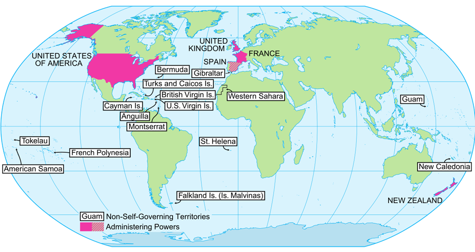
Life would change dramatically for the people of Oceania with the arrival of Europeans. The Dutch first made landfall in Australia in 1606 CE but simply explored and mapped the area and did not establish a settlement. In the late 18th century, the British established their first Australian settlement in what would later become the city of Sydney with the intention of creating an overseas penal colony. However, many of the prisoners sent to Australia were not hardened criminals who needed to be separated from the British Isles by an expansive ocean. Many were accused of petty crimes like theft and even children who had committed crimes were shipped to Australia. Today, around 20 percent of Australians are the descendants of these imprisoned settlers.European settlement of Australia challenged aboriginal land and water resources, but it was disease that had the most devastating effect on the indigenous population. At the time of British colonization, there were likely between 315,000 and 750,000 Aborigines in Australia. By the start of World War II, diseases like smallpox and measles reduced their numbers to just 74,000.New Zealand was originally claimed by the British as a colony of Australia, but then became its own colony in the mid-19th century. Around the same time, representatives of Britain as well as Maori leaders signed the Treaty of Waitangi. This treaty granted British colonists sovereignty over the governing of New Zealand but gave the Maori the rights to their tribal lands and resources and made them British subjects.Throughout the 19th and 20th centuries, European and Japanese colonial expeditions claimed most of the Pacific islands. Some islands were seen as strategic military bases. Others, such as France’s colony of New Caledonia, were transformed into overseas prison colonies following the British model. Still others were occupied for their resources and trade opportunities. In the decades following World War II, a number of islands achieved independence. Australia slowly increased its autonomy throughout the early 20th century, officially dissolving from British control in 1942. New Zealand gained independence from Britain in 1947. In the 1970s and 1980s, another wave of independence occurred, with Fiji, Tonga, and a number of other states gaining independence.Others were not granted independence and a number of Pacific islands remain colonies today. Hawaii was made a US state in 1959 largely against the wishes of its indigenous population. Guam became a strategic US Naval base in the Spanish-American War and later in World War II and remains a US territory today. Its residents are US citizens but cannot vote in elections. The vast majority of the world’s remaining colonies today are islands because of their strategic locations and resource potential, particularly after the United Nations Convention on the Law of the Sea.
Map of Non-Self-Governing Territories, 2012 (Derived from UN Map of Non-Self Governing Territories, Wikimedia Commons, Public Domain)
Art of Oceania properly encompasses the artistic traditions of the people indigenous to Australia, New Zealand, and the Pacific Islands. The area is often broken down into four separate regions: Polynesia, Micronesia, Australia, and Melanesia. The ancestors of the people of these islands came from Southeast Asia by two different groups at separate times. The first, an Australoid people and the ancestors of modern day Melanesians and Australian Aboriginals, came to New Guinea and Australia, with the Melanesians expanding as far as the northern Solomon Islands by 38,000 BCE. The second wave of people came from Southeast Asia 30,000 years later, where they reached further remote Pacific islands. These early people lacked a writing system and made works on perishable materials, so few records of them exist from this time.
By 1500 BCE, descendants of the second wave of settlers began to expand and spread into the more remote islands. At around the same time, art began to appear in New Guinea, including the earliest examples of sculpture in Oceania. From around 1000 BCE on, the Lapita people consolidated and began to create the contemporary Polynesian cultures of Samoa, Tonga, and Fiji. From there they ventured further out into the Pacific and settled the Marquesas and northern Cook Islands.
The Lapita
The Lapita were an early culture with an influential artistic tradition. Dating from about 1500 BCE to 500 BCE, they are thought to be the ancestors of the modern day cultures of Polynesia, Micronesia, and some parts of Melanesia. The culture was formed by the second wave of Oceanic settlers, and the name comes from the site of Lapita in New Caledonia, which was among the first places its distinctive sculpture would be found. Their art is best known by their ceramics, which include elaborate geometric motifs and sometimes anthropomorphic imagery. It is thought some of the designs may be related to modern Polynesian tattoos and barkcloths. The ceramics were created by firing a comblike tool that stamped the designs on to wet clay; each stamp would have one design and would be layered until an elaborate pattern was created. Their usage is believed to have been primarily practical, used in cooking, serving, and storing food.
Interaction with Mainland Asia
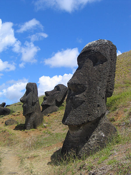
The period from 1000 BCE to 1000 CE is characterized by increasing trade and interaction between the Pacific Islands and mainland Asia. Starting around 600 BCE, works of the Dongson culture of Vietnam—known for their bronze working—can be found in Oceania, and their imagery has a strong influence on the indigenous artistic tradition. New areas were also settled during this time, including Hawaii, Easter Island, Tahiti, and New Zealand. Starting around 1100 CE, the people of Easter Island began construction of nearly 900 moai (large stone statues). At about 1200 CE, the people of Pohnpei, an island in Micronesia, embarked on another megalithic construction, building Nan Madol, a city of artificial islands and a system of canals. By 1500, the first European explorers reached Oceania. Although previous artistic and architectural traditions continued, the various regions began to diverge and record more distinct cultures.
Moai at Rano Raraku, Easter Island: Starting around 1100 CE, the people of Easter Island began construction of nearly 900 moai, or large stone statues of human-like heads.
European explorers, working at the limits of their technology and pushing beyond the edges of their known world, were regularly startled to find Polynesians already inhabiting the islands they had only just been able to reach. The term ‘Polynesia’ is a European one, and it reflects the experience of the European explorers who recognised that the people they encountered in this watery section of the planet shared elements of culture and language. Startled that other people could navigate the region earlier and more thoroughly than they had yet managed themselves, Europeans speculated on how the Polynesians had arrived. Interest in that story of human discovery continues and the story of the original exploration of the Pacific is continually being refined by archaeologists.Early European explorers were perplexed by the presence of Polynesians on widely scattered islands and sought to explain it. In 1722, Dutch explorer Jacob Roggeveen raised the possibility that the inhabitants of Rapa Nui (Easter Island) had been created there or otherwise directly placed there by God. Europeans, struggling to reliably reach previously visited Pacific Islands, also tended to discount the navigational abilities of Islanders, leading to the enduring idea that the Pacific Islands had been discovered and settled by survivors of vessels blown off course and out to sea. In the nineteenth century there was also some enthusiasm for the idea that the islands of Polynesia were the remnants of a sunken continent which had left only its mountaintops above sea level, holding survivors of a lost civilisation. Some early observers put forward the idea that Polynesians had migrated from Asia, an idea familiar in the present. During the nineteenth century, migration theories proliferated and variously suggested Aryan, European, and Semitic origins for Polynesians, as well as raising the prospect of waves of migration by different peoples across the Pacific at different times. The possibility of a South American origin for Pacific migration was also put forward, supported by biological evidence (in the form of sweet potatoes) of pre-European contact between Oceania and the Americas.
Map showing the progress of human exploration of the Pacific. 2022. By Pavljenko and from Wikimedia Commons. CC BY-SA 4.0
The development of the discipline of archaeology has changed the way in which the question of Polynesian origins is addressed, as have improved understandings of the ways in which the world itself has changed over time (the prospect of a sunken continent has been destroyed). When human beings first set out into the Pacific the region was physically different from the way it is now. Lower sea levels made the region more accessible from the west, and large amounts of evidence has led archaeologists to believe that the ancestors of Pacific Islanders came from southeast Asia.Approximately 30,000 years ago, when sea levels were at their lowest, people settled the Bismarck Archipelago and the northern Solomon Islands. Low sea levels had made those regions more accessible, and people arrived.About 26,000 years ago sea levels began to rise with global temperatures, and about 3,500 years ago a new phase of Pacific exploration began. This was a distinct phase of Pacific exploration, as rising sea levels had made islands smaller, and distances between them greater. Despite these challenges, people reached the islands of western Polynesia, and archaeologists associate this period with a range of artefacts that they think come from a distinct culture. The Lapita people are named after the archaeological site at which their distinctive pottery was first found, and further Lapita sites have been located within Oceania. Archaeologists have identified variations in decorative motifs and artefacts between remains at western and eastern Lapita sites, and between remains from different time periods. Lapita artefacts seem to have stopped being made about 2,000 years ago. Archaeologists find Lapita remains exciting because they indicate the existence of cultural connections across a wide swathe of the Pacific, and because they are traces of people who travelled out into the Pacific even when the land they were heading towards was out of sight over the horizon. Quite who the Lapita were, and what their connections with present-day Pacific Islanders might be, remains unclear, but their presence in the Pacific is part of the human history of the exploration of that ocean.
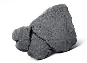
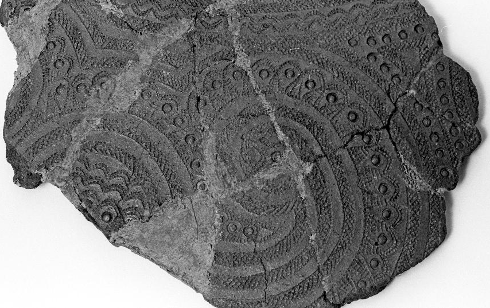
Cast of a fragment of Lapita pottery with typical motifs. Cast c. 1950. From The Met. CC0 Public Domain
Terracotta fragments, Lapita people, c. 1000 B.C.E., red-slip earthenware, Santa Cruz Islands, south-east of Solomon Islands (Department of Anthropology, University of Auckland, CC BY-NC-ND 3.0)
Archaeologists get very excited when they find pieces of Lapita pottery. Why? Because the sequential depositing of potsherds (fragments of pottery) in an easterly direction across the island groups of the Pacific has become the pivotal evidence that tells the extraordinary story of the peopling of the vast Pacific Ocean. Pieces of the distinctive red-slipped pottery of the Lapita people have been recovered from sites spanning thousands of miles across the Pacific from the outer reaches of Southeast Asia, through the island groups often referred to as Micronesia and Melanesia, and into the central Pacific and Polynesia.
Captain James Cook, A voyage towards the South Pole, and round the World. Performed in His Majesty’s ships the Resolution and Adventure, in the years 1772, 1773, 1774, and 1775 (London: Printed for W. Strahan; and T. Cadell in the Strand. 1777) (photo: Daderot CC0 1.0)
An archaeological puzzle
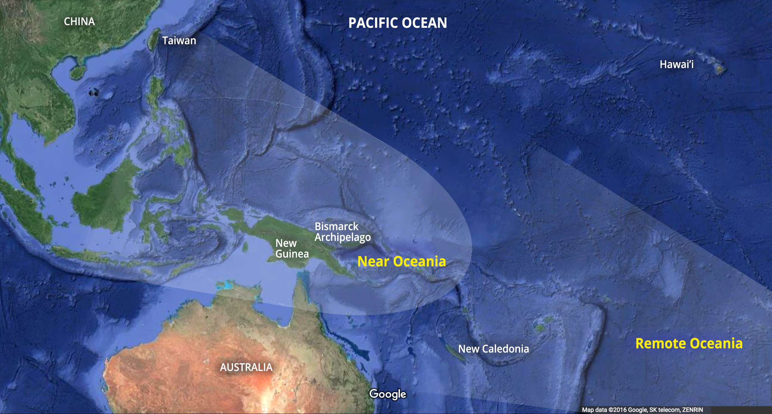
Though Pacific Islanders have their own richly detailed historical accounts of the exploration of their “sea of islands,” European speculation about how and when the Pacific was populated began with James Cook and other European voyagers of the Enlightenment era (1700s). [1] Theories based on thin historical conjecture proliferated in the late eighteenth and nineteenth centuries, often at odds with Islanders’ own knowledge systems. At first it was thought that the inhabitants of what is now known as Near Oceania colonized the islands southeast of the Solomon group, now referred to as Remote Oceania (see map below). It was not until archaeologists began to undertake stratigraphic archaeology in the Pacific from the 1950s onwards that this idea was debunked—mostly due to evidence provided by the multiple archaeological sites where Lapita pottery has been found.
Archaeologists now believe that, somewhere between 4,000 and 3,500 years ago, a group of people who had sailed from the area around Taiwan in Southeast Asia arrived by canoe to the beaches of the Bismarck Archipelago. The new arrivals, who we now know as the Lapita people (named for the beach on the island of New Caledonia where a large number of pottery sherds were found), spoke a different language than the people they would have encountered there. These local people had been living on the large island now known as New Guinea and the surrounding islands for between 60,000 and 40,000 years. [2] Aside from their language and different genetic stock, the Lapita were different to those they encountered because they had sophisticated seafaring and navigation capability—and they manufactured and decorated ceramics in very particular ways. We can only theorize about the political and environmental pressures that drove these people to set out to sea in search of new places to live. Nevertheless, the pieces of broken but stylistically related potsherds distributed across thousands of miles of islands, laid down in datable stratigraphic layers, have revealed important information about the ancestors of the contemporary peoples of the central Pacific.
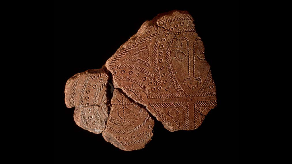
Terracotta fragments, Lapita people, red-slip earthenware, Watom Island, Bismarck Archipelago (photo: Merryjack CC BY-NC-SA 2.0)
Travel and trade
Lapita pottery was shaped by hand, and perhaps using a paddle-and-anvil technique to thin the walls, but without the aid of a potter’s wheel. It is low-fire earthenware (no evidence of Lapita kilns have been found). This means that the dry clay pots would likely have been placed in open fires to harden—the descendants of the Lapita people in Fiji and other areas still make pottery in this way. There is some geographical variation in the shapes and sizes of the pottery but most were simple bowls, some had pedestal feet, and others were flat-bottomed vessels. We know that the pottery was generally not used for cooking because carbon residues are not normally found on the potsherds. Rather, the evidence suggests that much of the pottery was used for serving food, while larger vessels were likely used for storage.
The makers of the Lapita pottery blended clay with a particular type of sand. The sand was needed as a temper to make the vessels more durable during firing. Both the clay and sand are only found in certain areas of the Pacific. The islands in Remote Oceania are far less diverse in terms of geology than those in Near Oceania, and only a limited number of island locations had deposits of the clay used to make the pottery.
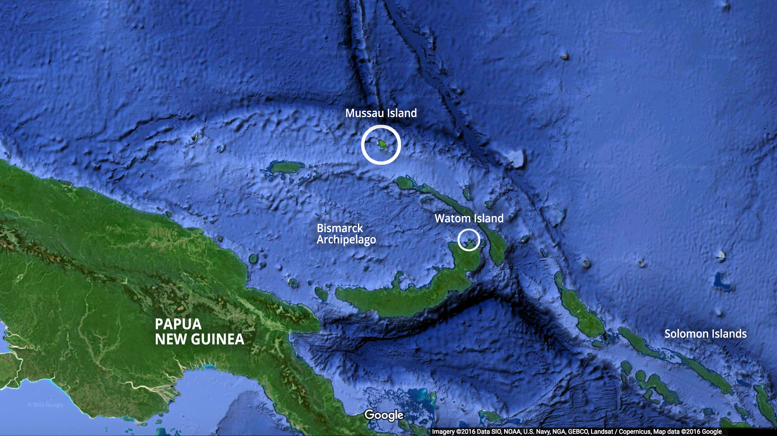
Analysis of the composition of the sherds has revealed valuable information about where the raw materials came from. The archaeologist Terry Hunt has analyzed a large number of potsherds found by the archaeologist Patrick Kirch at Talepakemalai and other Mussau Lapita sites (see map above). The Mussau islands, which are mostly limestone, are one of the island groups with very little clay. Hunt showed that a large number of the potsherds found there had been made from materials brought from other places, indicating that either the raw materials or perhaps the pots themselves had been imported. This reveals that the Lapita people had the means and the need to travel and trade across significant ocean stretches—their “sea of islands.” Perhaps, the most remarkable thing about the Lapita pottery sherds is that despite the remaining sherds being found thousands of miles apart, they share a formal and discernible design grammar that archaeologists can analyze. In fact, it is the decoration of Lapita pottery that holds the greatest amount of information for archaeologists.
Terracotta fragments, n.d., Lapita people, red-slip earthenware (Department of Anthropology, University of Auckland, CC BY-NC-ND 3.0)
A design grammar
The decoration of the pottery consists of stamped and incised motifs that adhere to a very regular, structured, and repeated set of specific patterns. The motifs were applied to the surface of the vessel with a small dentate (tooth-like) stamp and/or drawn free-hand with a sharp edge of some sort. The pattern stamps used included both linear and curved shapes of various lengths, as well as round forms. Once a pot was decorated, a paste of white coral lime was applied to the pattern which had the effect of making the delicate patterning stand out against the reddish-brown clay. Types of patterns range from simple to complex geometric forms, and include anthropomorphic face designs (image, top of page) found on Talepakemalai in the Mussau island group (see map above). The anthropomorphic pattern was a characteristic of early Lapita pottery, and is not present on pottery found in the upper (and therefore newer) archaeological layers of sites further east in Polynesia.
Archaeologists contend that those responsible for decorating the pots used a very restricted range of motifs and combined these in specific ways on particular areas of the pots. In other words, the ancient people who decorated the pots followed the rules of a defined design system. As Kirch notes “although we may never know what was in the minds of those potters and design-makers, we can understand in a more formal or structural sense their system of art and design, and use this as a tool for tracing the history of Lapita pottery in time and space.” [3]
Painted Barkcloth (Masi kesa), late 19th–early 20th century, Lau Islands, Fiji, 85.1 x 419.1 cm (Metropolitan Museum of Art) “The repeating geometric motifs of many tapa cloths at times resemble those seen on pottery produced by the Lapita peoples, who were the ancestors of present-day Polynesians.”
A major breakthrough in the analysis of the Lapita design system came in the 1970s when Māori archaeologist Sydney Moko Mead developed a coherent formal system to categorize the design elements and motifs found on Lapita pottery. Mead’s system drew inspiration from linguistic analysis and has a set of components that form the building blocks of the “grammar” of the Lapita design system. These include: design elements, motifs, zone markers, and design fields. Even though the design system changed incrementally through time and within specific geographical areas as people moved across the Pacific, the underlying structural patterns and rules of the system remained the same. From an analytical point of view, the systemized grammar of design has meant that potsherds found in one site can be categorized and compared with others found in multiple other sites to provide evidence of the movement of the Lapita people in particular timeframes. What’s more, vestiges of the design motifs and the grammar of the system are apparent in contemporary tattooing, barkcloth decoration and other art forms throughout contemporary Remote Oceania (image above).
As the Lapita people moved east past the Bismarck archipelago they likely reached the Samoan and Tongan Island groups around 800 B.C.E. They then paused for 1200 years when another phase of colonization began, and people headed toward the most distant reaches of the Polynesian triangle. People arrived in Hawai‘i by c. 1000 C.E., and Rapa Nui/Easter Island and Aotearoa/New Zealand by about 1200 C.E. For the most part, the further east the Lapita people headed, the simpler their patterns became. The most recent potsherds, found in the most easterly and south westerly locales, are minimally decorated. It seems that within a couple of hundred years of arriving in what are now Samoa and Tonga (see map above), Lapita pottery and its distinctive design decoration had all but disappeared. When Europeans arrived in the Pacific in the 1700s and 1800s, the ocean going long-distance seafaring canoes were gone, but the knowledge of distant islands and oral histories of voyaging remained. Archaeologists are still actively working to untangle the history of this early pottery, and with each successive discovery, to add to the extraordinary story of the Lapita people.
Source: Dr. Jane Horan, “Terracotta fragments, Lapita people,” in Smarthistory, January 1, 2017, accessed July 31, 2024, https://smarthistory.org/lapita/.
To the north and east of Australia lie the islands known as Melanesia. These islands form one of the most culturally complex regions of the entire world, with 1,293 languages spoken across the Solomon Islands, Vanuatu, New Caledonia, and the island of New Guinea (politically divided into Indonesia’s West Papua Province and the nation of Papua New Guinea).
Map showing Melanesia (source: Tintazul, CC BY-SA 3.0)
It is also a region of great antiquity. New Guinea has been settled for around 45,000 years, the Solomon Islands for 35,000 years, and Vanuatu and New Caledonia for about 4,000.
Throughout Melanesia, people lived in small scale societies often without strong leadership systems. Instead, communities were bound by ties of family and by complex networks of trade and exchange. Trade routes could link distant communities, and trading canoe voyages covered extensive distances. The daily round of food gardening, hunting, and in coastal areas, of fishing, were enriched by many rituals, often involving the production of remarkable objects such as the famous malangan carvings of New Ireland, and body decorations. In general, Melanesians do not worship gods, but acknowledge the spirits and other beings sharing the landscape with them, and their ancestors.
European contact
Europeans first passed by these islands in the late sixteenth century, but sustained contact only began in the mid-nineteenth century. The British Museum collections date back to some of the earliest voyages in this later period of contact. The Museum continues to collect, adding objects which reflect the contemporary development of the three independent nations and two dependent colonies now in the region.
This unique archaeological and ethnological reserve, located in the Northern Territory, has been inhabited continuously for more than 40,000 years. The cave paintings, rock carvings and archaeological sites record the skills and way of life of the region’s inhabitants, from the hunter-gatherers of prehistoric times to the Aboriginal people still living there. It is a unique example of a complex of ecosystems, including tidal flats, floodplains, lowlands and plateaux, and provides a habitat for a wide range of rare or endemic species of plants and animals.
Some of the oldest rock art is located at Ubirr in Kakadu. Figures there were created in what has been called x-ray painting. This spot also provides excellent views of Arnhem Land.
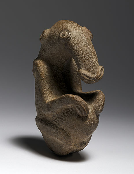
Ambum Stone, c. 1500 B.C.E., greywacke, 20 x 7.5 x 14 cm, Ambum Valley, Enga Province, Papua New Guinea (Australia National Gallery, Canberra)
The Ambum Stone is a masterfully crafted stone carving, created around 3,500 years ago in the highlands of the island we now know as New Guinea. Who actually carved it and for what original purpose is not known. Nevertheless, the Ambum Stone had a life as a religious object for a group of people in Papua New Guinea before becoming an aesthetically beautiful and intriguing artifact of exotica in a Western gallery. More recently it suffered a mishap that left it broken, and the publicity around this thrust the Ambum Stone into ongoing political debates about who owns historical artifacts. Every chapter of this carving’s history has been entangled with personal and political intrigue, and chronicles a bigger story about colonization and shifting and evolving structures of power.
There are 12 recorded artifacts like the Ambum Stone: ancient stone mortars and pestles excavated from New Guinea, usually from the mountains of its interior. The smoothly curved neck and head of the Ambum Stone suggest its possible utility as a pestle when we consider its size—at about 8 inches high, the “neck” of the creature it depicts can be held in the hand, and its fat base could have been used to pound food and other materials. The tops of other ancient pestles from New Guinea are distinguished by human or bird heads, or by fully sculpted birds, while the mortars also include geometric imagery alongside avian (bird) and anthropomorphic (human) depictions.
The Ambum Stone is prized above all others not only for its age—it is one of the oldest of all sculptures made in Oceania—but also for its highly detailed sculptural qualities. It has a pleasing shape and smooth surface, and the slightly shiny patina on some of its raised details suggest it has been well handled. It was made from greywacke stone, and its finished shape may suggest the original shape the stone it was carved from. Greywacke is a very hard sedimentary stone, which often has fracture lines and veins that reveal its age and formation. Much greywacke has been subjected to significant amounts of tectonic movement, pressure and heat over extended periods, and some of the greywacke in the islands of the Pacific is more than 300 million years old. Imagine carving something as symmetrical and aesthetically pleasing as the Ambum Stone using only stone tools. It must have taken its maker many months to chip out the rough shape then finish it carefully, and the time and effort involved in its making suggests it was special and valued by whomever it was made for.
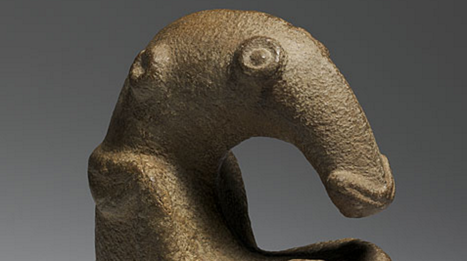
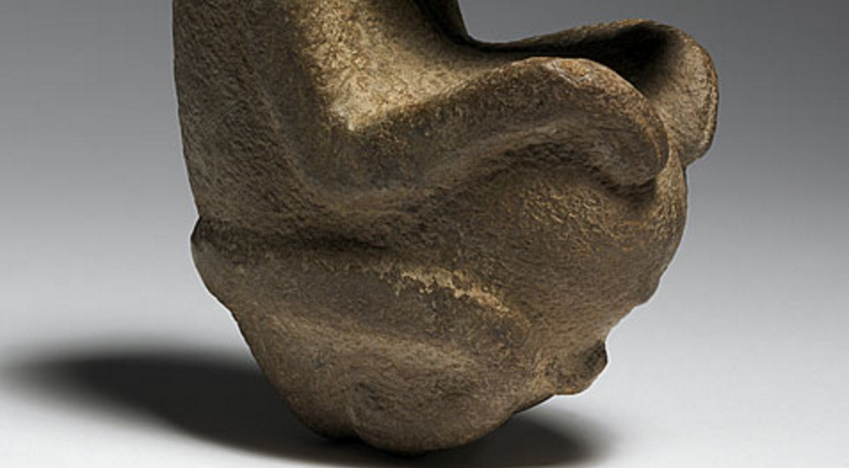
Carved in the form of some kind of animal, its features are rounded and include a freestanding neck, elegantly curved head and long nose, and upper limbs that hug its torso and appear to enclose a cupped space above its belly. Stylized eyes, ears and nostrils are depicted in relief, and shoulder blades and what could be an umbilicus suggest the maker’s understanding of anatomy. While it is possibly a fetal-form of a spiny anteater known as an echidna, which is thought to have been valued for its fat prior to the introduction of pigs, it might also be a bird or a fruit bat, and some have speculated that it represents a now extinct mega-sized marsupial.
Ambum Stone (detail), c. 1500 B.C.E., greywacke, 20 x 7.5 x 14 cm, Ambum Valley, Enga Province, Papua New Guinea (Australia National Gallery, Canberra)
Ritual use in Papua New Guinea
When the Ambum Stone first became known to Westerners in the 1960s, it was being used by a group of people called the Enga who live in the western highlands of Papua New Guinea. For the Enga, the Ambum Stone and other objects like it are called simting bilong tumbuna which literally translates as the “bones of the ancestors.” [1] This is the Enga term for a class of cult objects which were used as powerful ritual mechanisms where ancestors reside. While the ritual object is not actually an ancestor per se, paradoxically, such sacred objects are believed to have a life of their own, and they can even move around, mate, and reproduce. It would seem—for the Ambum Stone at least—they can also go on adventures and create controversy.
Enga society is based on an organizational power structure known as the “big man” system, and the negotiation of power depends on commanding natural resources like pigs and produce, as well as supernatural forces like the goodwill of the ancestors (or the Christian God). Power is vested with those “big men” who can cajole, organize, or even manipulate other people into giving them resources so these can be redistributed at big ritual events. Before the Enga decided to convert to Christianity in the wake of the arrival of missionaries and colonization in the 1930s, the Ambum Stone and other objects like it were imbued with supernatural powers through ritual processes. They were buried in a group’s ancestral land and regular sacrifices of pigs were needed to appease the stones and the ancestors that resided in them. With the appropriate care they could ward off danger and promote the fertility and vigor of the tribe and the land.
Ambum Stone (detail), c. 1500 B.C.E., greywacke, 20 x 7.5 x 14 cm, Ambum Valley, Enga Province, Papua New Guinea (Australia National Gallery, Canberra)
Christianity, colonization, and commoditization
When Christian missionaries arrived in Papua New Guinea, people largely embraced the new religion, the new system of power that came with colonization, and the consequent Australian administration. The big man system was maintained but the way of managing the supernatural took on a Christian guise. Objects like the Ambum Stone lost some of their former potency, but under the “Whiteman’s gaze” they acquired new parameters of value as “primitive art” and were therefore worth money.
The Ambum Stone came to distill exoticism, imbued with all the romance perceived by Westerners in the stark differences of Papua New Guinean ways of seeing the world, and evoking a primitivism and purity lost to the West. This exoticism was enhanced by its specific dimensions and proportions that meet a certain aesthetic ideal from a Western point of view. All of this, its “primitive” and aesthetic value drove its pathway through a murky set of transactions, culminating in its acquisition by the Australian National Gallery in 1977, where it is valued as a priceless antiquity.
Originally sold by two young boys (at the urging of resident missionaries) for 20 shillings to the European owner of the trade store in Wabag (Enga Province), it was then sold by an intermediary to Philip Goldman, a London art dealer. Goldman subsequently offered it to the British Museum, before selling the sculpture to the Australian National Gallery in Canberra, Australia. In his negotiations with the Museum and by way of justifying his asking price, Goldman compared the Ambum Stone to Jackson Pollock’s Blue Poles which the gallery had purchased a few years earlier: basing the “primitive” Ambum Stone’s value on that of a work of modern art. Eventually, the Australian National Gallery agreed to pay Goldman $115,000 United States dollars for the stone.
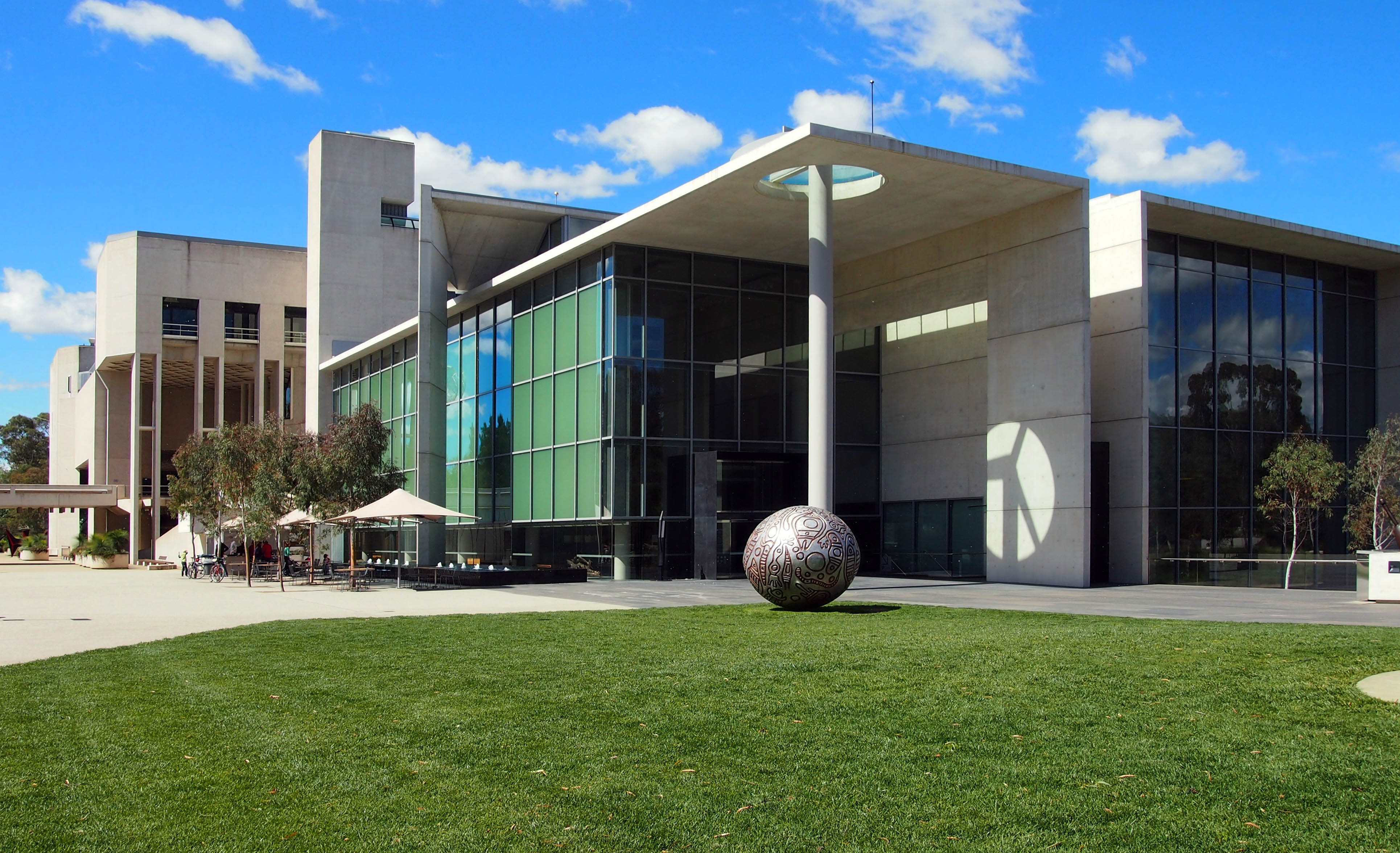
Australian National Gallery, Canberra (photo: Nick-D, CC BY-SA 3.0)
Protecting the cultural heritage of Papua New Guinea
The Papua New Guinea Museum attempted to buy the Ambum Stone when it was offered to the Australian Museum, but was unsuccessful. Papua New Guinea became an independent state in 1975, and robust legislation and other legal structures have been in place since 1913 that prohibit the export of objects of antiquity and relevance to Papua New Guinea as a unique place in the world. The country has not been able to afford to make purchases on the international antiquities market because prices are too high for a developing nation. Further, Papua New Guinea has not had the capacity to enforce its legislation internationally until recently. Whether the Ambum Stone was legally exported from Papua New Guinea remains a point of contention.
Many objects of New Guinea’s historical material culture were shipped to foreign museums and galleries for “safe keeping.” Other desirable or even potentially valuable objects were smuggled out illegally. In 1977, the legal standing of the Papua New Guinea state to reclaim objects of national significance was bolstered by the opening of the Papua New Guinea National Museum and Art Gallery, complete with state of the art storage and exhibition facilities. It was staffed first by Europeans who in turn trained Papua New Guinea nationals in museum management who were politically and philosophically intent on having antiquities returned to Papua New Guinea. Over the years the Papua New Guinea Museum and Art Gallery has perfected its systems of export control and its capacity to enact legal proceedings against those intent on taking antiquities out of the country. They have also been able to successfully negotiate the return of objects and whole collections that were sequestered away for safe keeping elsewhere in the world. Nevertheless, there are limits to their ability to enforce the return of objects such as the Ambum Stone.
Damage and restoration
In 2000, while on loan to a French art museum, the Ambum Stone was accidentally dropped and shattered into three main pieces and various shards of stone. It was later discovered by conservators, as they pieced it back together, that what had previously been thought to be old breaks, mended while in Papua New Guinea, were actually fracture lines of the greywacke stone. Fissures and grooves containing organic material were examined and were used to suggest its date of 1500 B.C.E. The Ambum Stone was carefully repaired, but other damage had been done. News of the incident made it into international media, which in turn generated the discussion about what the Ambum Stone—a registered antiquity belonging to Papua New Guinea—was doing in the possession of an Australian gallery in the first place. Whilst the Ambum Stone remains in Canberra, arguably the controversy over this artifact has meant that Papua New Guinea’s capacity to negotiate at the global level has been bolstered.
At the heart of the recent chapters of the story of the Ambum Stone is a narrative about colonialism and its legacy. The Ambum Stone was made and imbued with particular meanings and values by a group of what we now know as Papua New Guineans, and then relocated to a Western museum where it has been reinterpreted within a framework of aesthetics and exchange, where we continue to marvel at it—and exoticize it—because of its origins, and the mysteries we perceive in the pages of its story, remain closed to us.
Notes:
[1] Egloff, Brian, Bones of the Ancestors – The Ambum Stone: from the New Guinea Higlands to the Antiquities Market to Australia (Lanham: Altamira Press, 2008), p. 1.
Additional resources
Egloff, Brian, Bones of the Ancestors – The Ambum Stone: from the New Guinea Higlands to the Antiquities Market to Australia (Lanham: Altamira Press, 2008).