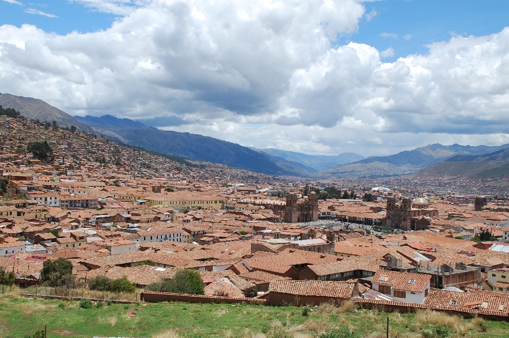
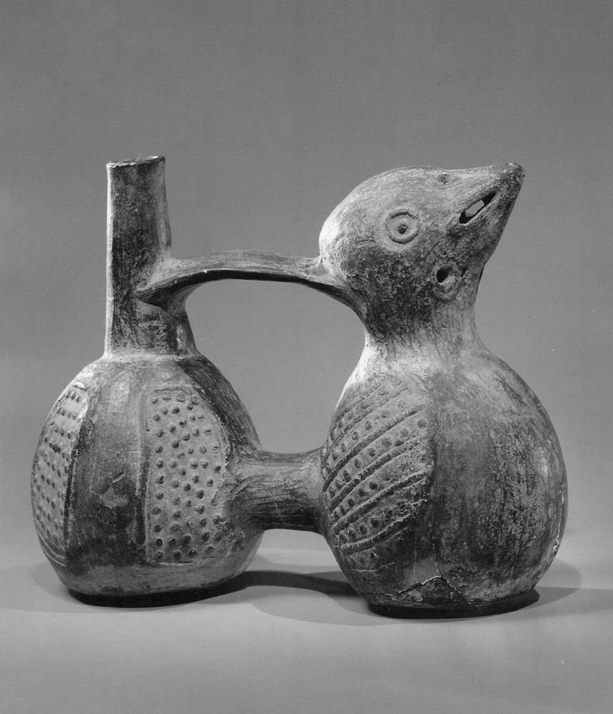
At around the same time the Aztec Empire was expanding across Mesoamerica, an equally impressive new civilization was on the rise in the Andes region of South America. Known today as the Inca, its cultural and technological roots extend back to the earlier Andean cultures of the Moche, Nazca, and Tiwanaku. The heart of what became the Inca Empire was the city of Cuzco, located more than eleven thousand feet above sea level in the central Andes and northwest of the shores of Lake Titicaca. But centuries before it became an imperial city, it was a relatively modest agricultural community where the predecessors of the Inca farmed potatoes and maize and raised llamas and guanacos.
According to one Andean tradition, the origin story of the Inca began with a great flood that displaced four brothers and their wives and sent them on a mission to find fertile land where they could settle. During the journey, one of the brothers acquired incredible and supernatural strength. Consumed with jealousy, the other brothers sealed him in a cave and left him to die. They continued on, somewhat remorseful, but on the outskirts of Cuzco, two were mysteriously turned to stone. This left only one brother, Ayar Manco, who reached Cuzco, dipped his golden cane into the ground, and founded the city.
Ayar Manco. This eighteenth-century depiction of Ayar Manco, by Inca tradition the founder of the city of Cuzco, names him its first king and shows him with his golden staff. (credit: “Manco Capac, First Inca, 1 of 14 Portraits of Inca Kings” by Dick S. Ramsay Fund, Mary Smith Dorward Fund, Marie Bernice Bitzer Fund, Frank L. Babbott Fund, The Roebling Society, The American Art Council, Anonymous, Maureen and Marshall Cogan, Karen B. Cohen, Georgia and Michael deHavenon, Harry Kahn, Alastair B. Martin, Ted and Connie Roosevelt, Frieda and Milton F. Rosenthal, Sol Schreiber in memory of Ann Schreiber, Joanne Witty and Eugene Keilin, Thomas L. Pulling, Roy J. Zuckerberg, Kitty and Herbert Glantz, Ellen and Leonard L. Milberg, Paul and Thérèse Bernbach, Emma and J. A. Lewis, Florence R. Kingdon/Brooklyn Museum/Wikimedia Commons, Public Domain)
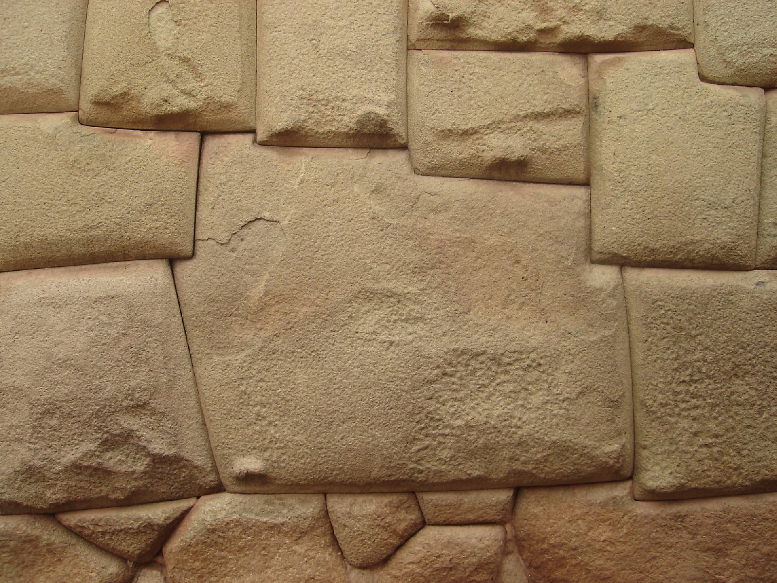
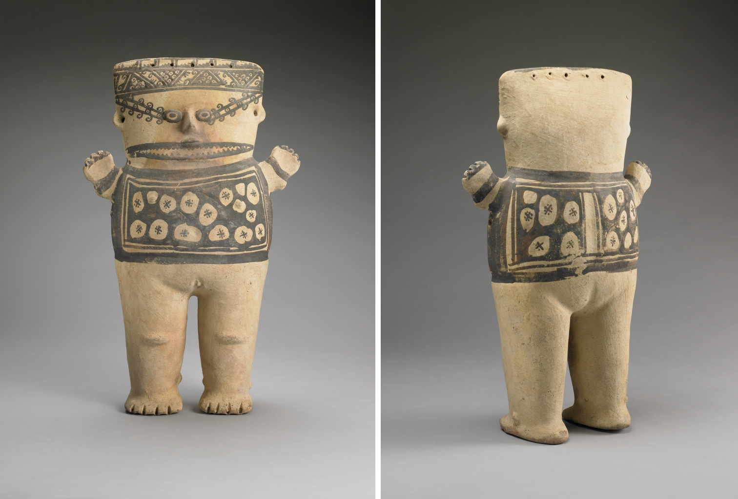
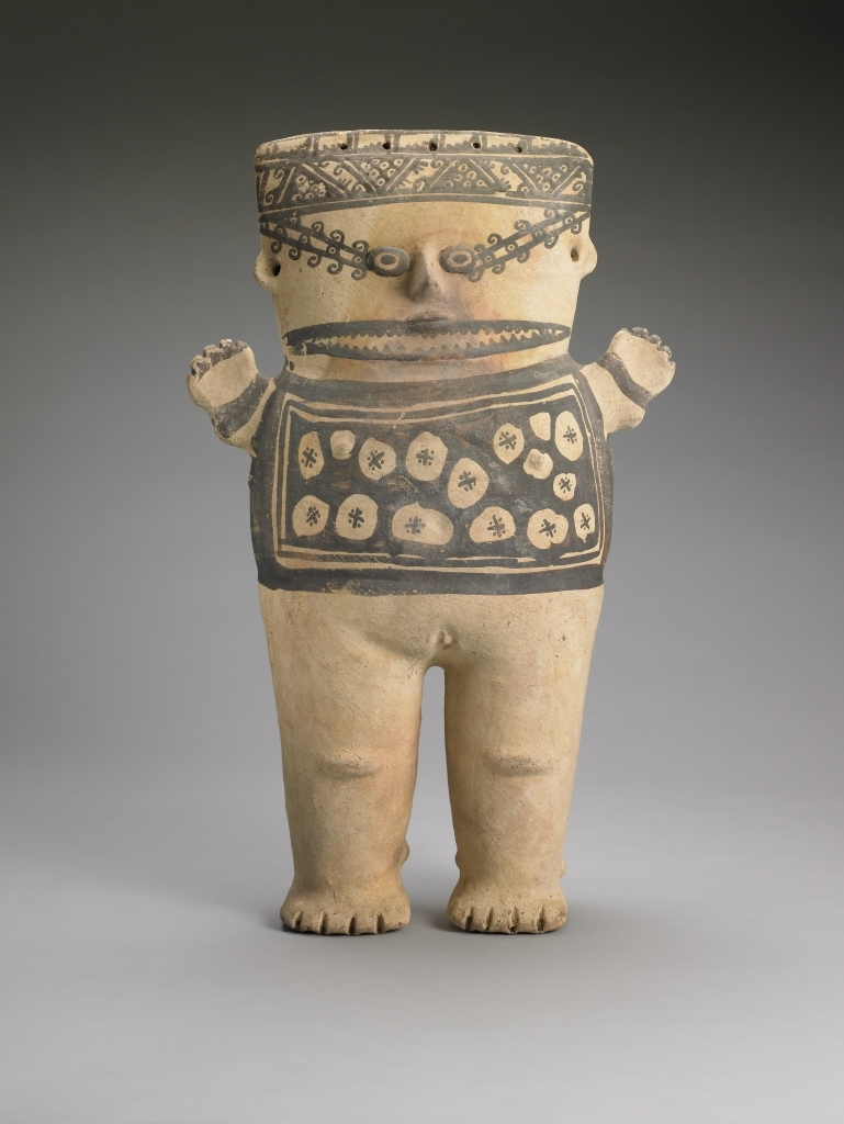
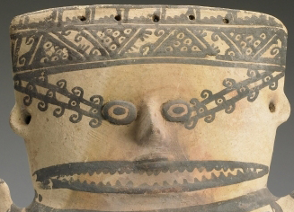
The fantastical story of the Ayar brothers, with its descriptions of magic and supernatural events, is clearly partly fictional, and it is not the only origin myth about the Inca. However, it may preserve a kernel of truth about the early group that founded Cuzco, perhaps after some type of migration prompted by changes in climate. We may never fully know, but based on historical and archaeological evidence, we do know the people of Cuzco emerged as agricultural villagers by around 1000. Through both peaceful and violent means, they assumed a dominant position in the larger surrounding region. Over time, their numbers grew, and they became one of a number of small military powers in the Andean region, centered on the growing city of Cuzco. As master stonemasons, the Inca were capable of carefully carving stones so they fit tightly together . At its height in the early sixteenth century, Cuzco was an impressive stone city built high in the Andes.
Inca Stonework at Sacsayhuamán. While many of the Inca-built parts of Cuzco were destroyed in later centuries, the sixteenth-century site of Sacsayhuamán nearby preserves its ancient walls of stones, so skillfully hewn as to fit together tightly without mortar. (credit: “Peru – Cusco Sacred Valley & Incan Ruins 005 – Sacsaywamán” by McKay Savage/Flickr, CC BY 2.0)
The leap to imperial expansion is explained by another Inca legend, this time telling of a military challenge from a rival group known as the Chanka and involving real historical figures. When the Chanka arrived at Cuzco, King Wiraqocha fled the city with his heir, leaving only a small group of nobles aligned with another son, Yupanki, to stand their ground. The defenders’ act of courage inspired the creator god of the Inca to intervene by transforming the surrounding stones into warriors who helped Yupanki defeat the Chanka. In the aftermath of the victory, the story goes on, Yupanki assumed the additional title of Pachacuti, meaning “cataclysm.” But the victory also led to an internal dispute between Pachacuti Yupanki and the reigning king, his father. This was ultimately resolved in Pachacuti Yupanki’s favor, and he assumed control of Cuzco and the Inca, whereupon he began a series of wars of expansion that gave birth to the Inca Empire.
While this story was partly contrived, there is no doubt that Inca expansion did occur, and Pachacuti appears to have been a real leader. The empire’s growth began in earnest around 1430 during his reign, and as king he oversaw the conquest of much of modern Peru. His successors, Thumpa and Wayna Qhapaq, further expanded the empire by adding territory far to the south in today’s Chile and Argentina, to the east in the edges of the Amazon basin, and to the north in Ecuador and Colombia. These wars were costly in lives and material, but they were also important for sharpening the skills of the Inca military.
Inca warriors wore helmets and cloth armor, carried shields, and were equipped with weapons like clubs, spears, slings, and axes. Typically, they could use their great numbers to overwhelm and awe the enemy into capitulation. If that failed, they rushed into the fray, often with little discipline but with great courageous resolve. Apart from the sheer power of numbers, the Inca military excelled in its ability to move swiftly along the empire’s complicated highland road systems to surprise the enemy and put down any emerging rebellions.
Inca Soldiers. The Inca armies could use their vast numbers to intimidate rivals into capitulation. In this seventeenth-century image by Huamán Poma de Ayala, a Peruvian chronicler of the Spanish conquest, the Inca soldiers in their feathered helmets are on the right, and their enemy faces them on the left. (credit: “Huamán Poma de Ayala’s picture of the confrontation between the Mapuches (left) and the Incas (right)” by Unknown/Wikimedia Commons, Public Domain)
The empire created through conquest was divided into four administrative regions controlled by close relatives of the emperor. Each region was then broken down into a number of provinces, organized generally along ethnic lines and ruled by an imperial governor selected from the Inca nobility. A great variety of crops were produced across the empire including potatoes, coca, cotton, and maize. Surpluses were held in large storehouses to feed the armies and provide sustenance in times of famine. The subjects of the empire were also expected to provide labor for the construction of roads, bridges, palaces, and religious structures and to serve as messengers, transport food to storehouses, or serve in the military. Certain members of each household submitted their labor tax while others stayed home to manage the family’s affairs.
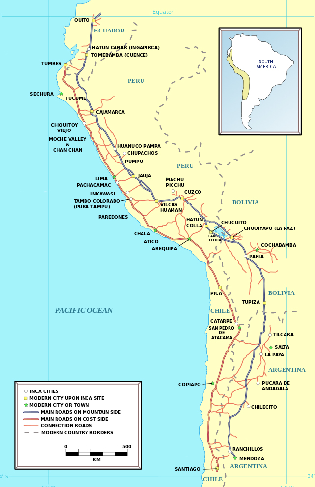
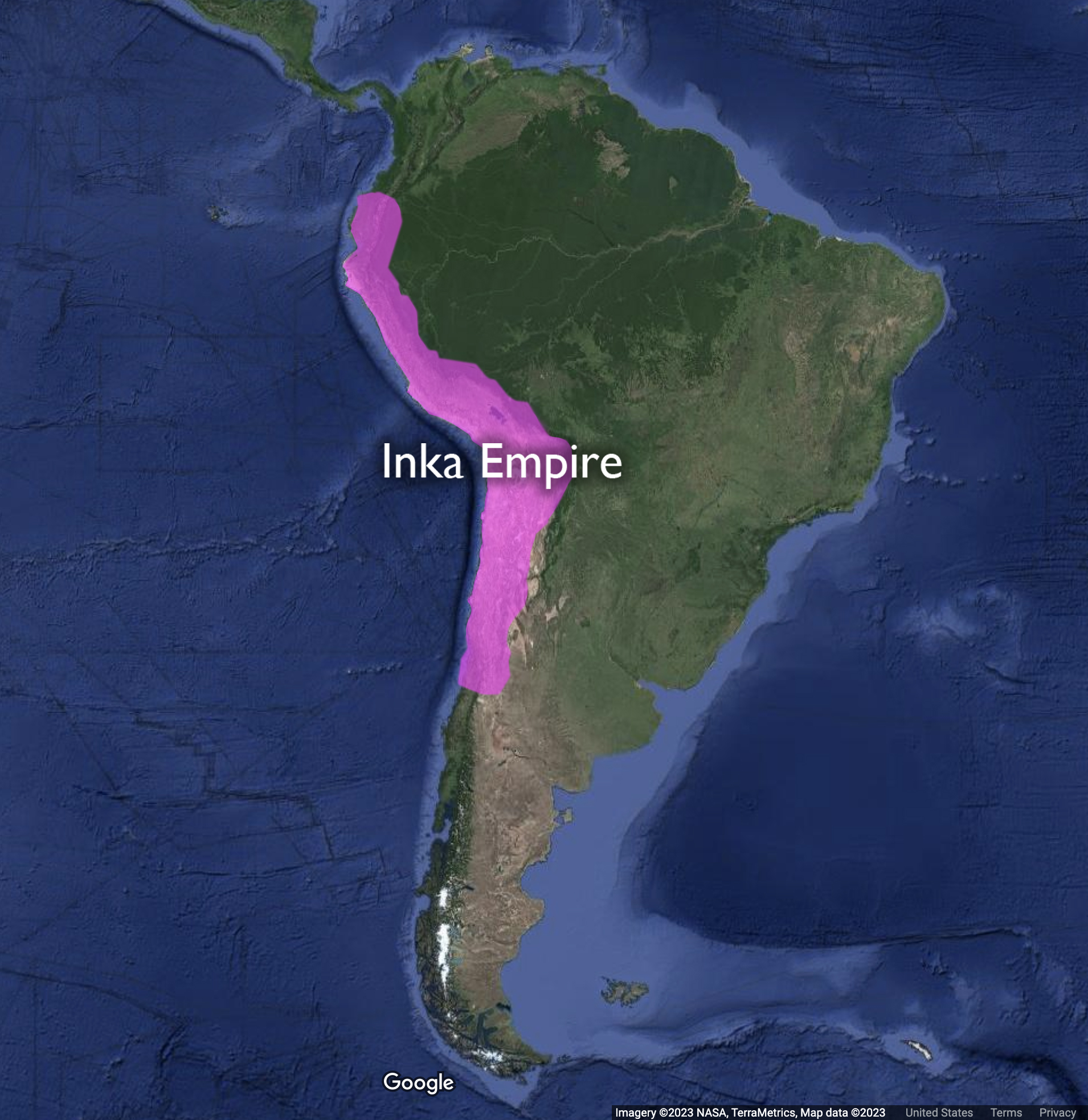
The Inca Empire. At its height in the early sixteenth century, the Inca Empire controlled an enormous area that reached from modern Columbia down into modern Chile and Argentina. It was divided into four administrative regions: Chinchansuyu, Antisuyu, Cuntinsuyu, and Collasuyu. (attribution: Copyright Rice University, OpenStax, under CC BY 4.0 license)
Inca Quipus: Writing with String
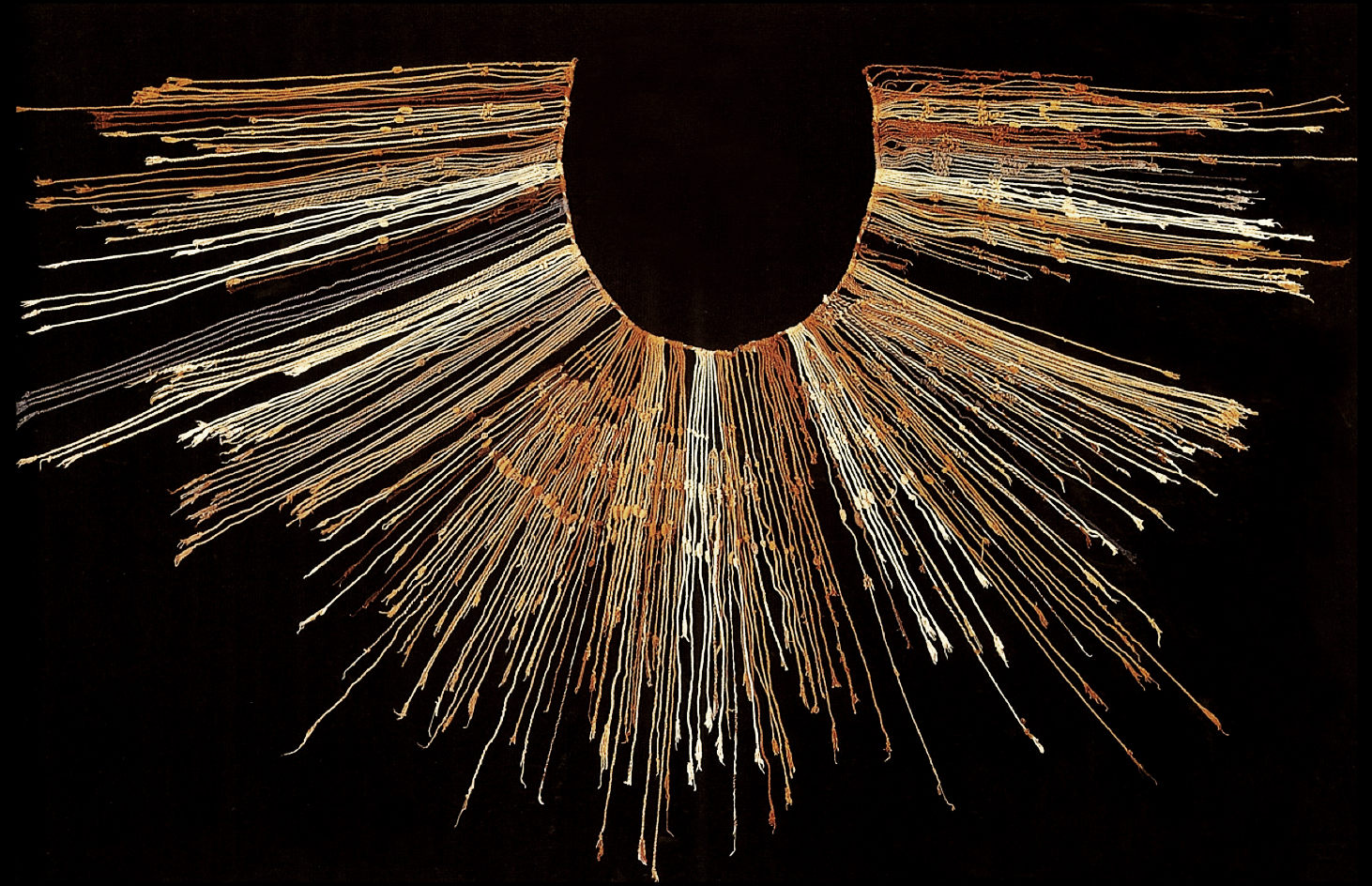
Unlike the Maya, the Inca did not have a writing system that could be inked into a codex or carved in stone. But they did have an ingenious recordkeeping and communication system that relied on a portable device called a quipu (“kee-poo”), made of a great number of knotted strings.
An Inca Quipu. The quipu of knotted string was a complex but portable Inca recording device. This fragment was made between 1400 and 1600. (credit: “Quipu fragment” by Yale University Art Gallery/Wikimedia Commons, Public Domain)
While many were destroyed by the Inca and later the Spanish, and much knowledge necessary to decipher them has been lost, surviving quipus have been carefully studied. They could record quantitative information like census and tax data, land allocations, the movements of armies, and astronomical observations. They also held qualitative information like ideas and possibly even poems. Different-colored strings and different types of knots that could be tied, untied, and retied made many thousands of combinations possible.
The Spanish were reluctant at first to believe that quipus accurately preserved information. The sixteenth-century explorer Pedro de Cieza de Léon reported:
When I was at Marcavillca, in the province of Xauxa, I asked the lord Guacarapora to explain it in such a way as that my mind might be satisfied, and that I might be assured that it was true and accurate. He ordered his servants to bring the quipus, and as this lord was a native, and a man of good understanding, he proceeded to make the thing clear to me. He told me to observe that all that he, for his part, had delivered to the Spaniards from the time that the governor Don Francisco Pizarro arrived in the valley, was duly noted down without any fault or omission. Thus I saw the accounts for the gold, the silver, the clothes, the corn, sheep, and other things; so that in truth I was quite astonished.
—Pedro de Cieza de Léon, The Second Part of the Chronicle of Peru, translated by Clements R. Markham
According to Garcilasco de la Vega, born in the sixteenth century to Spanish and Inca parents, quipus could even record poems:
They were composed in accordance with a fable they had, as follows: they say that the Creator placed a maiden, the daughter of a king, in the sky with a pitcher full of water which she spills when the earth needs it, and that one of her brothers breaks it occasionally, and the blow causes thunder and lightning. . . . The fable and verses, Padre Blas Valera says he found in the knots and beads of some ancient annals in threads of different colors.
—Garcilasco de la Vega, Royal Commentaries of the Incas and General History of Peru, translated by Harold V. Livermore
Why might the Spanish have destroyed many quipus?
How would you go about translating a quipu? What methods might you employ?
Apart from military violence and an organized imperial administration system, the Inca used religious symbolism to hold their empire together. A complex ritual calendar was overseen by religious experts whom the king and nobles regularly consulted before making political or military decisions. The Inca used human sacrifice in some rituals, but apparently not as readily as the Aztec of Mesoamerica. Among their most important deities was the sky god, who could manifest in a number of different forms such as the creator god Wiraqocha, the thunder god Illapa, and the sun god Inti. Inti was of particular importance because Inca rulers claimed direct descent from him. They constructed temples to Inti around the empire, encouraged his worship, and incorporated representations of conquered peoples into Inti’s key temple in Cuzco. In this way, the Inca cemented stronger ties between their rulers and the large and diverse empire they had created.
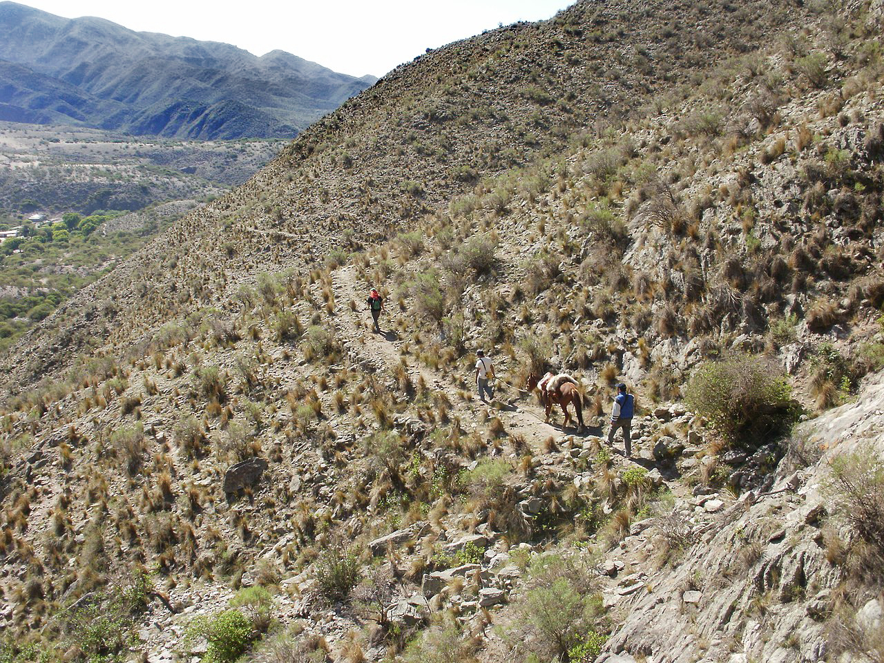
One of the empire’s most important features, and one that held its expansive territory together, were the many roads and bridges that laced through its vast domains. Unlike the Aztec Empire, which expanded across a far more topographically consistent landscape, the Inca Empire included large mountain ranges, canyons, deserts, and narrow coastal valleys. Travel and communication were difficult in this extreme landscape and necessitated a technologically sophisticated road and bridge system. While elements of the network predated the Inca, it was under Inca rule that the larger network was expanded and greatly improved. At the height of the empire, the system may have included as many as twenty-five thousand miles of roads. These roads were as diverse as the landscape itself, including straight passages across flat land, winding paths and staircases around and up mountains, and numerous canyon-spanning bridges made of rope, stone, and wood. On them the Inca armies traveled, and goods produced in the provinces made their way to the imperial storehouses.
An Inca Road. The mountainous terrain of the Inca Empire necessitated roads like this one to connect the many important cities and regions.(credit: “Stone steps and mountains on the Inca Trail” by “Mx._Granger”/Wikimedia Commons, CC0 1.0)
Like the Aztec Empire, the Inca Empire had just reached its height on the eve of the Spanish arrival in the early 1530s. Diseases brought by Europeans had already weakened it by then, even leading to the untimely death of Emperor Wayna Qhapaq in 1528. Just a few years later, the Spanish conqueror Francisco Pizarro reached Ecuador with his small army. There he found new Inca subjects eager to ally themselves with a possible enemy of the empire, while the Inca themselves were in the midst of a minor civil war over who would ascend the newly vacated throne. By 1532, the Spanish had entered the conflict and emerged masters of the empire, upon which they constructed their own system.
Further Reading and Viewing
In the fifteenth century, the Inca built a large palace complex high in the mountains above Cuzco that is now called Machu Picchu. You can tour the impressive ruins of Machu Picchu at this link.
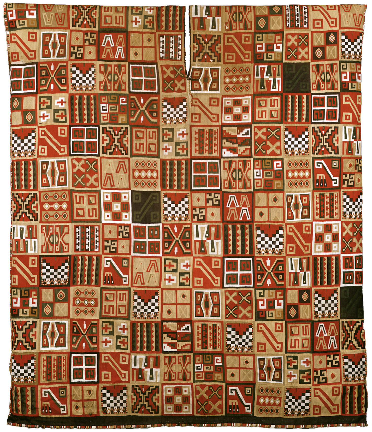
The Inka, like the Aztecs (or Mexica) of Mesoamerica, were relative newcomers to power at the time of European contact. When Francisco Pizarro took the Inka ruler (or Sapa Inka) Atahualpa hostage in 1532, the Inka empire had existed fewer than two centuries. Also like the Aztecs, the Inka had developed a complex culture deeply rooted in the traditions that came before them. Their textiles, ceramics, metal- and woodwork, and architecture all reflect the materials, environment, and cultural traditions of the Andes, as well as the power and ambitions of the Inka empire.
Along the Inka road system or Qhapaq Ñan today, Pucará del Aconquija, Argentina (photo: Ministerio de Cultura de la Nación Argentina, CC BY-SA 2.0)
An Empire of Roads—and Cords
Map of the Qhapaq Ñan (Inka road system) (map: Manco Capac, CC BY-SA 3.0)
The Inka empire at its greatest extent sprawled from the modern-day city of Quito in Ecuador to Santiago in Chile. The Inka called their empire Tawantinsuyu, usually translated as “Land of the Four Quarters” in their language, Quechua. At the center of the empire was the capital city of Cusco. The empire was connected by a road system—the Qhapaq Ñan—that was used for official Inka business only. Soldiers, officials, and llama caravans carrying food, ceramics, textiles, and other items used the roads, and so did message runners. These runners were stationed at regular intervals along the roads, so that messages could travel swiftly throughout the empire.
However, the messages that these runners carried were not written in the way we would expect. They were not made of marks on paper, stone, or clay. They were, instead, encoded into a knotted string implement called a quipu. Our knowledge of quipu remains limited. We have been able to determine only some of the ways that the quipu were used. Researchers continue to investigate this unique system of communication. The knots along the various cords recorded numbers, so that a knot with 5 loops could represent the number 5. The position on the cord could then determine what the number meant in a decimal system, so that a 5-loop knot could represent the number 5, or 50, or 500, and so forth.
Inka quipu (Museo Larco, Lima, Peru)
The cords of quipus are frequently composed of different natural and dyed colors, but the reason or meaning behind those colors so far eludes scholars. The numbers encoded in the quipus helped the Inka keep track of the tax-paying obligations of their subjects, record population numbers, harvest yields, herds of livestock, and other important information. Also recorded on the quipu were stories—histories of the Inka and other social information. However, scholars today still don’t know how that information was encoded into the quipu.
More valuable than gold
Quipus and other Inka fiber objects were made from yarn spun from alpaca fibers. Llamas and alpacas are the domesticated relatives of the wild camelids of the Andes, the guanaco and vicuña, and all of them are related to the camel. Alpacas and llamas were important to the functioning of the Inka empire, but they had been essential to the lives of Andeans for millennia. Llamas provided meat as well as acting as beasts of burden—an adult male llama can carry up to 100 pounds. Alpacas provided soft, strong wool for textiles and rope-making.
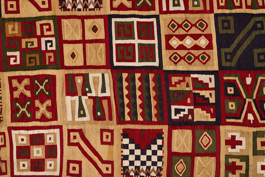
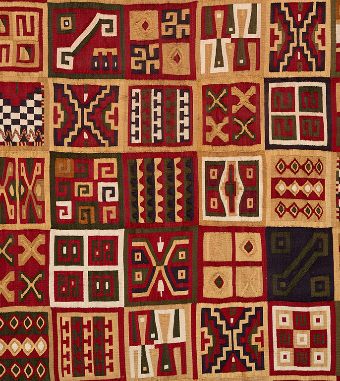
All-T’oqapu Tunic, Inka, 1450–1540, camelid fiber and cotton, 90.2 x 77.15 cm (Dumbarton Oaks, Washington D.C.)
When the Spaniards encountered the Inka, they were confused by the fact that they considered textiles more valuable than gold. Textiles were integral to the structure of the Inka empire. Acllas, or “chosen women,” were kept in seclusion by the Inka to weave fine textiles (called qompi). These textiles mostly took the form of tunics and mantles. Some were distributed as high-status gifts by the Sapa Inka to cement the loyalty of local lords throughout the empire. Others were burned as sacrifices to Inti, the sun god and divine ancestor of the Inka ruling class. This shows us just how highly the Inka regarded textiles: they were fit for a god.
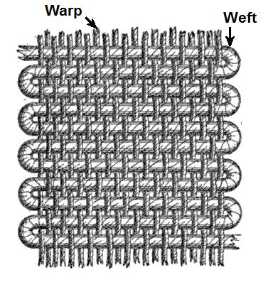
Diagram of warp and weft, (image: Ryj, CC BY-SA 3.0)
The acllas were not the only ones who wove. People of all ages spun, dyed, and wove textiles. The quality of wool, the fineness of its spinning, the relative rarity of the dye, and the skill of its weaving all determined the value of a textile. Some kinds of textiles were reserved for nobility or for warriors. The super-fine wool of wild guanacos and vicuñas was reserved only for the Sapa Inka’s garments.
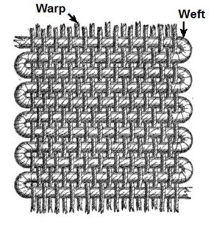
A textile is created using a grid of warp (usually vertical) threads, which act as the support or skeleton of the fabric, and weft (usually horizontal) threads, which are passed under and over the warp threads. Where the weft threads cover the warp creates the surface design of the textile, somewhat like pixels in a computer image. The “pixel size” is determined by thread fineness. Decoration on Inka textiles was based in this grid structure, resulting in geometric designs.
Inka metalwork
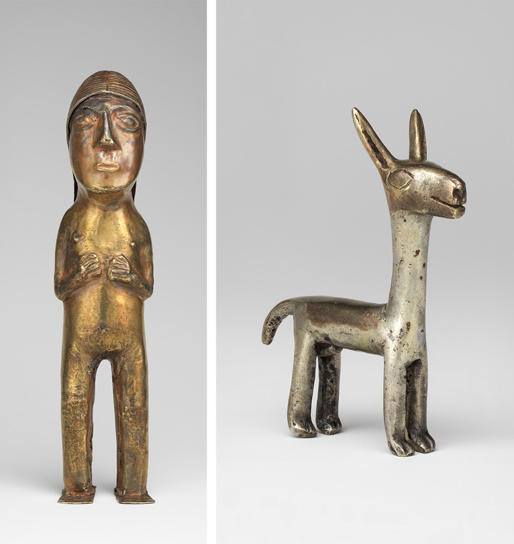
Despite the value they placed on textiles, the Inka did also create works out of gold and silver, but unfortunately, most were melted down by the Spaniards for ease of transport, or destroyed because they were thought to be idols. Depictions of people, animals, and plants have survived. The plants tend to be quite naturalistic, while the people and animals are more abstracted. Human figures would likely originally have been dressed in miniature clothing. Figurines uncovered at the sites of human sacrifices on remote mountain peaks have been found dressed in finely-woven textiles with elaborate feather headdresses.
Left: Female figurine, 1400–1533, Inka, silver-gold alloy, 14.9 x 3.5 cm (The Metropolitan Museum of Art); right: Camelid figurine, 1400-1533, Inka, alloys of silver, gold and copper, 5.1 cm high (The Metropolitan Museum of Art)
Vessels for feasting
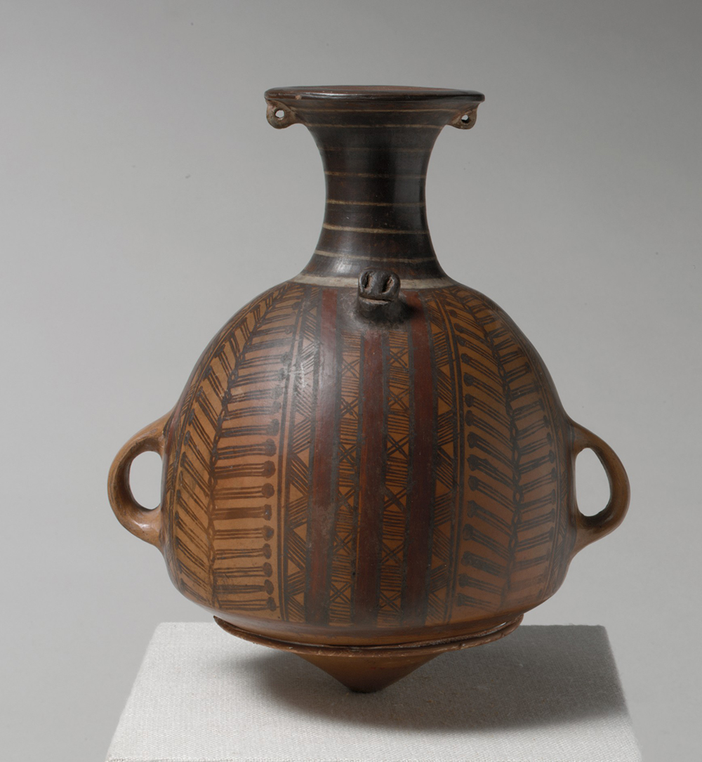
Ceramics were also important to the Inka empire. Large vessels were used to store foods such as corn and dried alpaca meat in warehouses along the Qhapaq Ñan, which could feed soldiers and imperial officials, or be distributed to the people in times of hardship. Big vessels could also be used to cook food and brew corn beer (asua or chicha) for feasting.
Storage jar or urpu, 15th–early 16th century, Inka, ceramic, 21.9 x 18.8 x 14.6 cm (The Metropolitan Museum of Art)
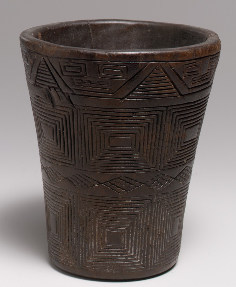
Keru vessel, 15th–early 16th century, Inka, wood, 14.6 cm (The Metropolitan Museum of Art)
Feasting (the ceremonial consumption of food and drink) was a method of cementing social and political ties, and the nobility were expected to provide feasts for large crowds on important occasions. Vessels called urpus were used for transport, storage, and asua-brewing. Some are over four feet tall. They have large handles on their sides and a thick protrusion from the base of the neck. A rope could be looped between the handles and over this protrusion, making it possible to carry on the back of a person or llama. The pointed base could be pushed into the ground to hold the vessel steady.
Asua would be drunk out of kerus, flared beakers made of wood, ceramic, or metal, depending on the status of the drinker. Kerus were often made in pairs, reflecting the social implications of drinking asua as a part of feasting. One keru from each pair would be larger than the other. The person of higher rank would drink from the larger keru and offer asua to the person of lower rank in the smaller vessel. By drinking together, they cemented the reciprocal obligations that required nobles to provide asua and food to the people, and those below them to provide taxes and loyalty to the rulers of the empire. The keru shown here is made from wood, and like the urpu vessel, has geometric designs.
Inka architecture
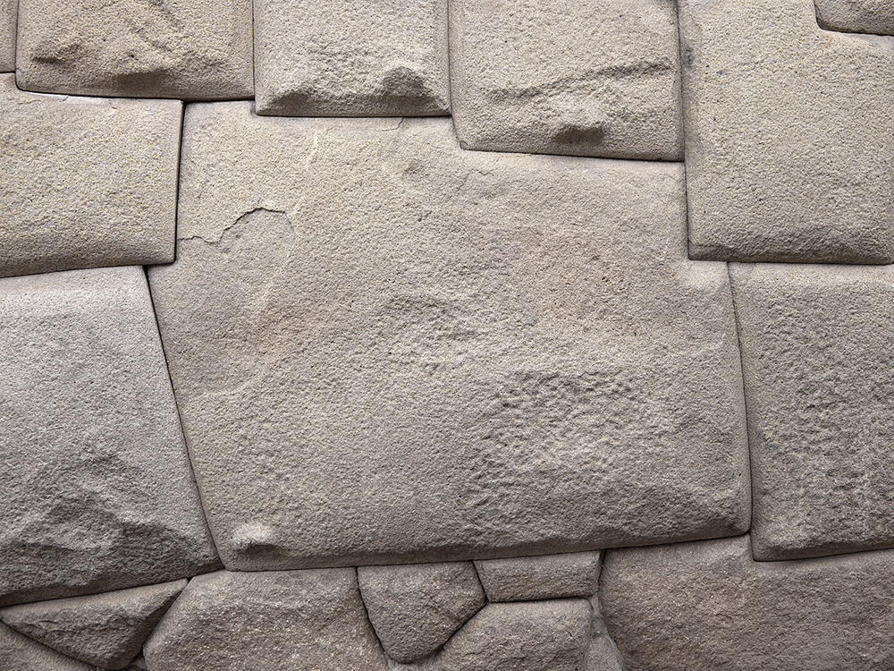
Twelve-sided stone, Cusco, c. 1440-1540 (photo: Sarahh Scher, CC BY-NC-SA 2.0)
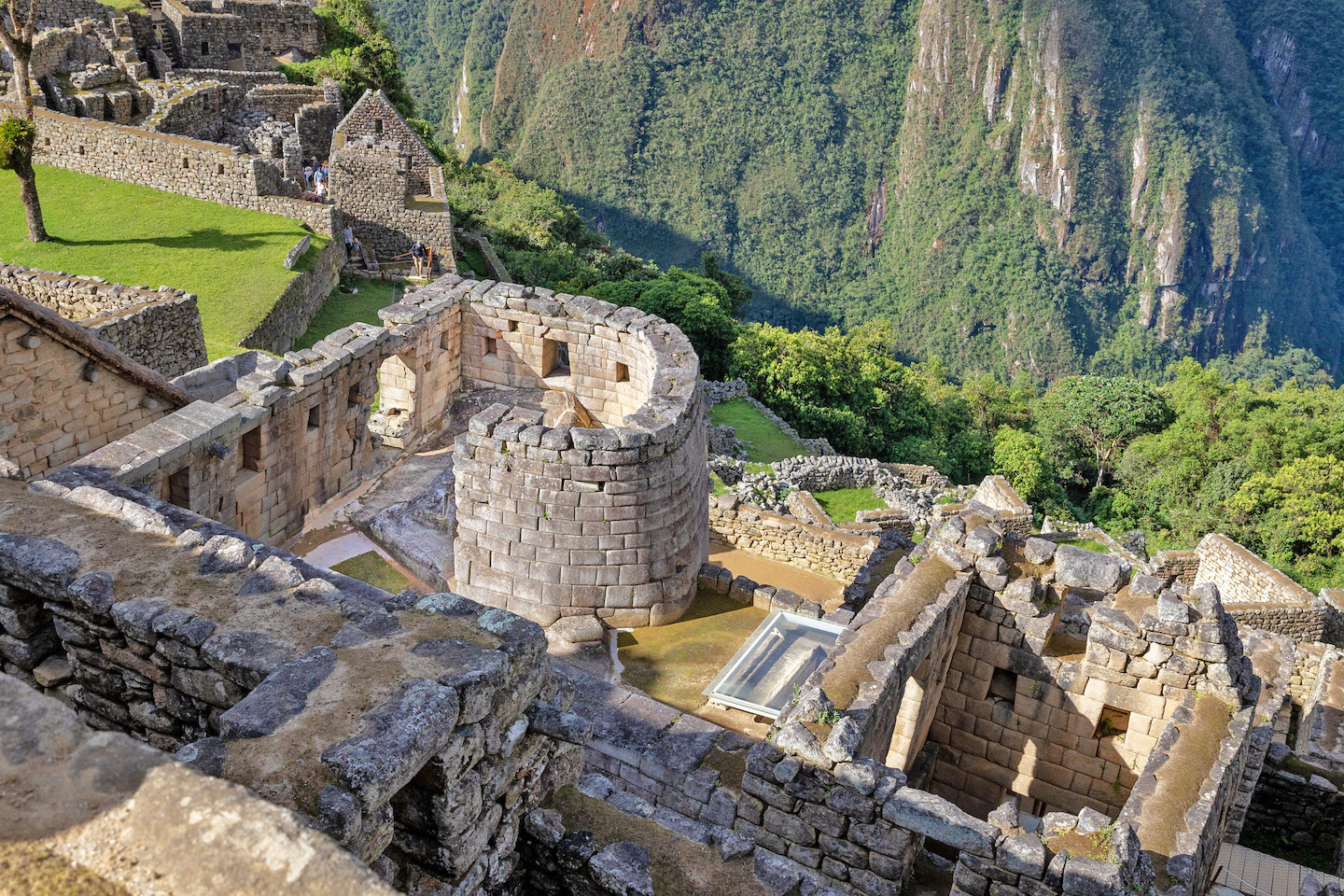
Perhaps the most well-known Inka art is their architecture. The Inka built everywhere they conquered, and their architectural style helped mark areas as belonging to the empire. Inka architecture is based on stone walls, fitted together in a very distinctive way. Instead of cutting stones into blocks and then laying those blocks together in rows, in some cases, the Inka would fit individual stones of varying sizes and shapes against each other, fitting them together like a puzzle. The stones would fit so closely that the Spanish remarked that a person could not even insert a knife blade between them.
Each stone was shaped so that it had a slight bulge or a slight indentation on the side where it would lay against another block. These bulges and indentations would slot together, holding the stones in place. It also allowed the stones to shift if they needed to—and they did need to, because Peru is seismically active and has frequent earthquakes.
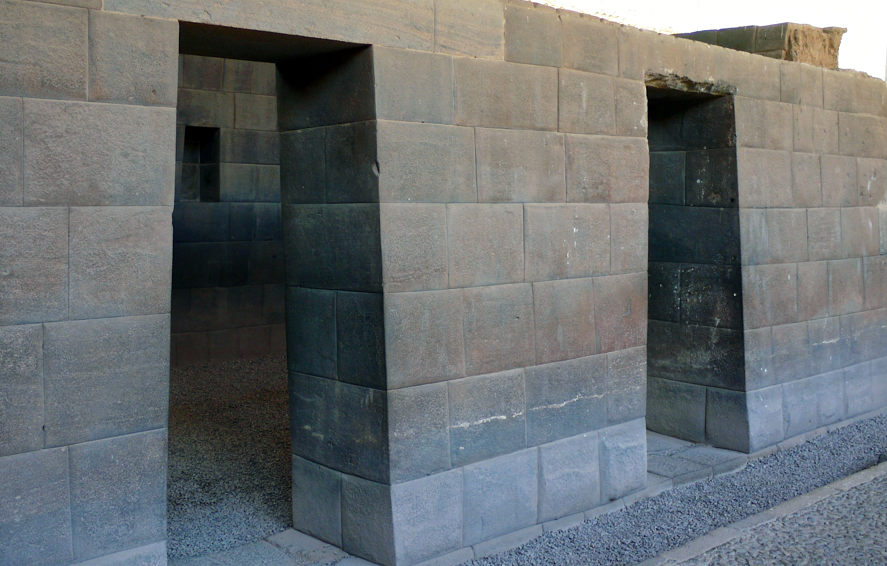
Stone doorways, Qoricancha, Cusco (photo: Jean Robert Thibault, CC BY-SA 2.0)
The doorways, windows, and niches placed in Inka walls have a signature vertical trapezoid shape, a recognizable and distinctive aspect of their architecture. Sometimes referred to as a keyhole shape, it is thought that this form is also something that helps stabilize the architecture during earthquakes. The roofs of these buildings were made of wood and thatch.
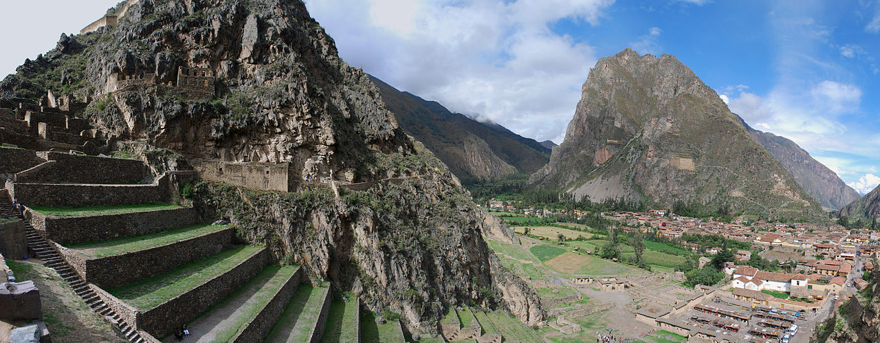
The terraces of Ollantaytambo, Peru (photo: Ivan Mlinaric, CC BY 2.0)
The Inka also built large architectural ensembles like the site of Ollantaytambo, which was a waystation along the Qhapaq Ñan. It consisted of storehouses, living quarters, and a series of terraces built into the side of a mountain. In most cases, the Inka used terraces as a way to stabilize mountainside soil for farming, but at Ollantaytambo they were planted solely with flowers—a show of the empire’s power through its ability to use stone, manpower, and water to do nothing but create a lavish and pleasant leisure space.
Inka traditions survive
With their defeat at the hands of the Spaniards, the Inka lost their place as divinely-descended leaders of their people. However, Inka nobles petitioned for and often won the right to be treated as elites in colonial Spanish society, and celebrated their heritage at Christian festivals, such as Corpus Christi. The privileges the nobles received did not translate to the rest of the population, though, and many people were deprived of their lands and personal freedom, required to pay taxes through often arduous labor.
Rebellions vying for a return to Inka rule occurred throughout the colonial period, the last of which took place in the 1780s. Peru finally achieved independence from Spanish rule in the 1820s, establishing a republican government. Modern residents of Cusco and its surrounding areas are still proud of their Inka heritage, and modern religious celebrations often incorporate parts of native culture into Christian practices.
Source: Dr. Sarahh Scher, “Introduction to the Inka,” in Smarthistory, September 15, 2017, accessed August 16, 2024, https://smarthistory.org/inka-intro2/.
LITERATURE
The Inka khipu
by Dr. Kylie E. Quave
Khipu (quipu) fragment with subsidiary cords, Inka, 1400–1570, cotton and indigo dye, 66.04 × 101.28 × 1.91 cm (Dallas Museum of Art)
The Inka of the Andean region of South America developed the largest native empire in the Americas, a region that included mountains, jungles, and desert coasts. They built impressive monuments and ruled diverse peoples, yet they did this without a way of writing. What the Inka did use was the khipu (or quipu in Spanish), a knotted string record-keeping device, leading some people to ask: what really is writing anyway?
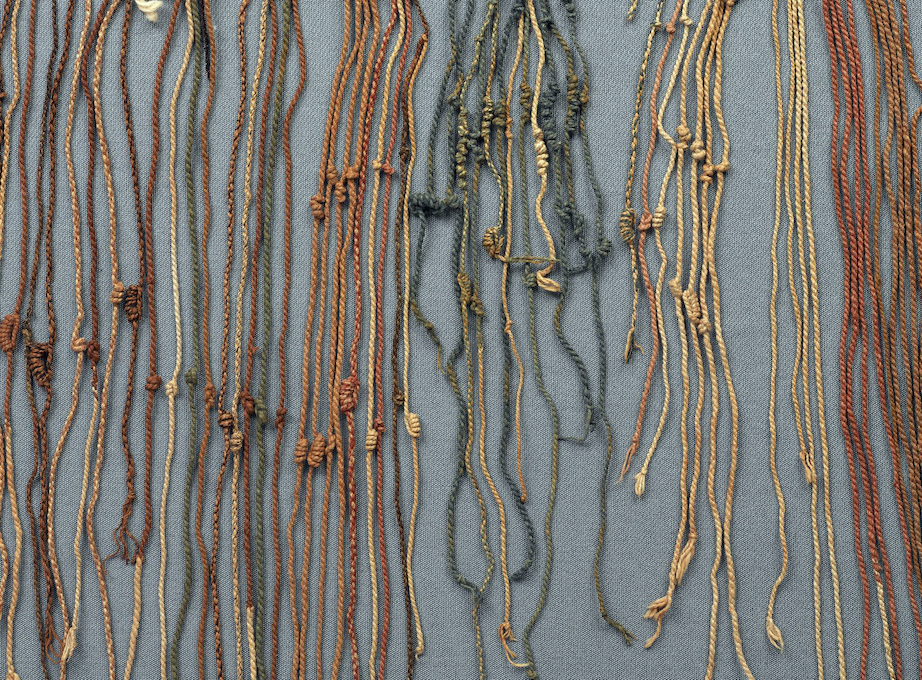
Writing without words
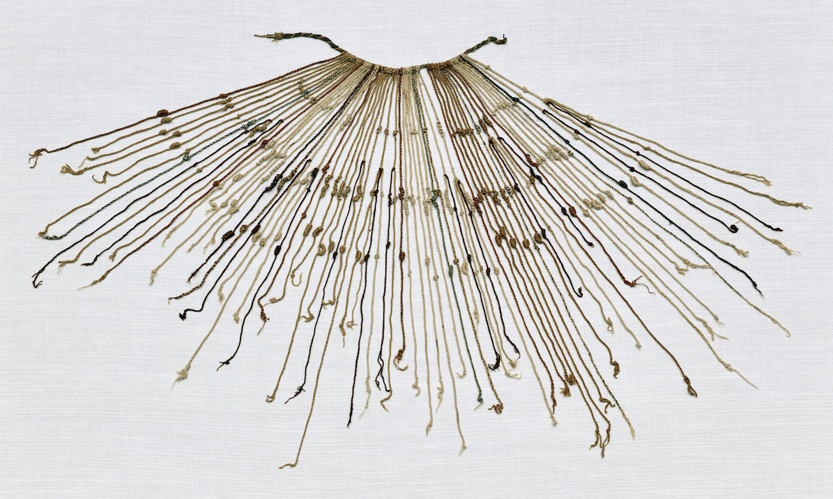
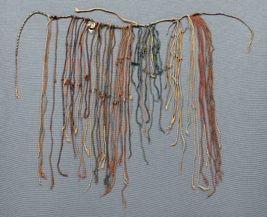
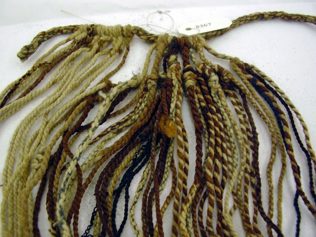
Inka khipus are bundles of woolen cords tied together with knots added to them to encode information. Some are all a natural beige cotton color, while others feature elaborate color combinations. Khipus are read from the looped, left side of a thick cord to the loose right side, with thinner knotted cords hanging down like long fringe. They were made, kept, and read by khipukamayoq, administrators who helped to rule the Inka empire by recording and keeping the information contained in the khipu.
Khipu, Inka, 1400–1532, cotton, 39 x 77 cm (The Brooklyn Museum)
Similar recording systems made of fiber cords appear to have been used prior to the emergence of the Inka (pre-1300s C.E.) until well after the dissolution of the Inka empire (after the 1530s C.E.). In the native language of Quechua, “khipu” means “knot.” But figuring out whether these knots should be considered a form of writing cannot be answered until people today learn how to read the khipus of the past. Writing is graphic representation of a spoken language—symbols that can be translated into meaning originally expressed in speech. Some scholars have called the khipu “writing without words.” What is clear, however, based on centuries of research by mathematicians, textile artists, anthropologists, archaeologists, historians, and others, is that khipus recorded and conveyed complex information of many types. Today, we are able to read the numbers knotted into most khipus, even if we don’t always know what they are counting.
Khipus recorded information about taxes and inventories, but also about time and calendric cycles. They reportedly recorded laws, judicial proceedings, and perhaps historical narratives. Even though the khipukamayoq read them in Inka times, these ancient objects cannot be fully read today. Some khipus have been described by khipu makers living in the 20th century who preserved local methods of recording, but those methods do not seem to apply to all Inka khipus.
Khipu, Inka, 1400–1532, cotton, 39 x 77 cm (The Brooklyn Museum)
One problem is that khipu literacy was not accurately documented from the 1500s forward, which was the time in which Europeans attempted to record Inka histories after the Spanish invasion and conquest began in the 1530s. The Indigenous chronicler Guaman Poma de Ayala wrote in a 1615 letter to the King of Spain that “with the strings they governed their entire dominion,” and he exalted the khipukamayoqs for their ingenuity and skill.
Yet the Spanish Colonial chroniclers who described the khipu and its functions contradicted each other. Some claimed they were composed of letters, while others claimed they were mnemonic (memory) devices without a consistent method of encoding information. The chronicler Garcilaso de la Vega (a descendant of both Inkas and Spaniards) wrote in the early 1600s that the khipu recorded numbers—not words—from which the record-keepers memorized historical events. He also wrote that some read the khipu to recount poetry and allegories. Amid these inconsistent characterizations by early chroniclers, the Spanish campaigns to extirpate idolatry resulted in them publicly burning some of the Inka khipus in 1583.
More recently, many researchers have agreed that khipus seem to not have a single, standardized language system. However, they have identified some groups of khipus that have matching segments in which groups of cords have the same or similar knotted numbers from one khipu to another. These khipu may have counted local people or goods repeatedly, and may have been encoded in the same way from one khipu to another in that place. If there was not an empire-wide recording system, then maybe khipukamayoqs from single villages or regions did use the same coding system.
The nature of these khipu groups demonstrates that administration and accounting must have been at least one purpose of khipu. Such records may have included censuses, labor taxation, troop movement, storehouse counts, and more. The Inka structure for governing peoples in their provinces organized them into bureaucratic units based on fives and tens (such as 50, 100, 500, etc.), often called decimal administration. Khipu structure and organization shows how they could have been tools for counting and administering populations: a khipu’s knots are organized vertically by 1s, 10s, 100s, and more. Also, pendant cords (hanging from the main cord) are often grouped in fives and tens. With different ethnic groups speaking diverse languages across the vast Andes, a system to track and account for millions of people and their labor and goods would have been useful.
The basic structure of a khipu most commonly consists of a main cord, pendants hanging from the main cord, as well as additional elements attached to pendants and main cord. The main cord is oriented horizontally, and one reads from the looped left side toward the loose right side of the main cord. Along its length, pendant strings are securely looped on to hang vertically downward. There may be one or more top cords, which would not hang downward but are rather tied on to sit upward if pulled away from the main cord. Many top cords summarize the information in the pendants, as their knots often represent the arithmetical sum of all the pendant cords hanging below.
Example of multiple subsidiary pendants hanging from pendants (Dallas Museum of Art; photo: Dr. Kylie Quave)
Some pendant strings include subsidiary pendants also tied on to the original primary pendants that hang below the main cord—making up secondary, tertiary, and quaternary pendants, and so on. These subsidiary cords may be corrections, exceptions, or subsets of information. Those who wrote and maintained khipus must have revised them at times, as some have bends in the pendant strings that suggest they were un-knotted or re-knotted.
Example of multiple subsidiary pendants hanging from pendants (Dallas Museum of Art; photo: Dr. Kylie Quave)
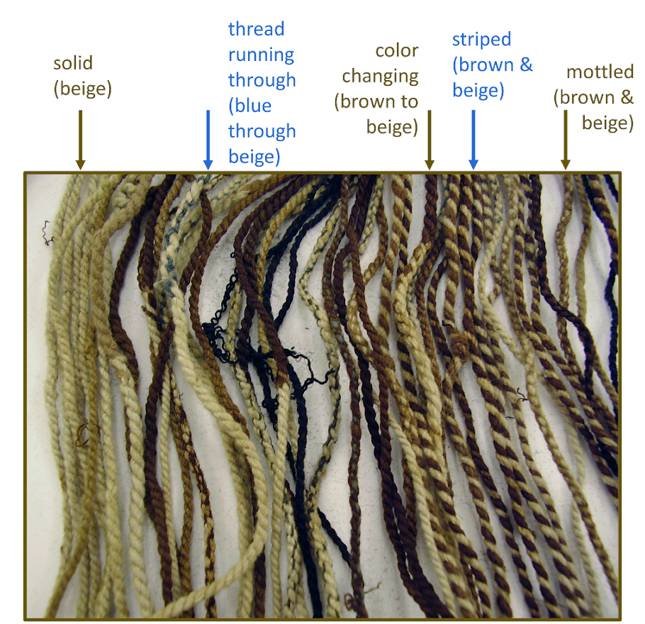
Khipus are most often made of camelid fiber, cotton, and other vegetal fibers that have been spun and plied. Both natural colors and colors achieved through dyes are found on khipus and other Andean textiles. Colored fibers are spun and plied together to make mottled or striped effects. Some khipu cords contain a single strand of a contrasting color, or the cord changes color mid-string. Spanish chroniclers writing in the 1500s and 1600s claimed that khipu colors held particular meanings, and researchers find it plausible that specific types of khipus each had their own suite of color symbols.
Once cords are prepared, the main cord and pendant cords are attached to each other. Pendants can be looped in one direction or another to attach, a decision that likely carries meaning within some khipus, just as the spin and ply directions of the cords likely carry meaning.
The knots tied onto khipu pendants can signify numerical and non-numerical information. There may be just one horizontal row (or register) of knots on pendant strings, but some khipus have several rows of aligned knots. Some of those rows of knots are organized in a decimal (or base-10 hierarchy), with the lowest row (farthest from the main cord) representing the 1s place, the next up as the 10s, then the 100s, the 1000s, and so on. Within each register, there are specific types of knots signifying numerical values. Today we count in a decimal system as well, but we use Arabic numerals. In our system, the ones place is to the right, and each digit goes up by a multiple of ten to the left (in the number 345, the 5 is in the ones place, the 4 in the tens place, and the 3 in the hundreds place). For the khipu, this decimal hierarchy goes from lowest row to highest row instead of right to left.
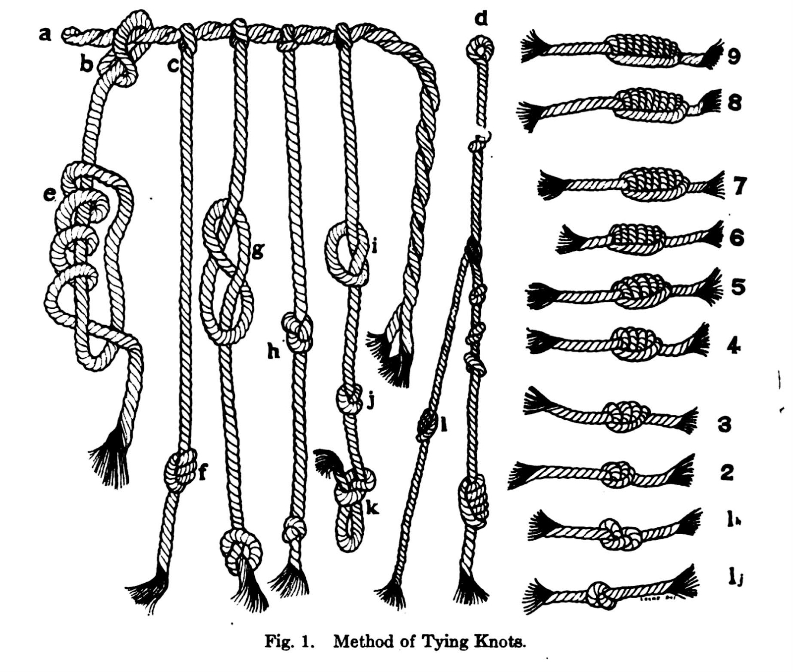
Knots e-f are long knots (values 2-9), knots g-h are figure-eight knots (value 1), and knots i-j are single overhand knots (10s, 100s, etc.) Drawing of knot-tying methods from L. Leland Locke’s landmark work The Ancient Quipu or Peruvian Knot Record (1923: fig. 1, American Museum of Natural History, New York).
Numerical khipus
Numerical value-signifying knots are formed in three ways. For single digits, they include: a “figure-8” knot for a value of “1”; or a “long knot”, which includes two to nine twists around its cord for the values 2-9 (see the diagram above). To signify tens, hundreds, and more in a decimal system, khipus include single overhand knots. Just one overhand knot in the tens row would be a 10 value, while two or more overhand knots in a cluster would indicate 20 to 90. In the hundreds row, they would indicate 100, 200, and so on. Each row on a numerical khipu has a value of up to 9, 90, 900, and so forth. The total value of that pendant is found by adding each row. For example, in the diagram above, string d has a value of 135: there is a single overhand knot in the 100s row at the top (100), three single overhand knots in the second row (30), and a long knot with five turns in the lowest row (5).
Narrative khipus
Khipus that diverge from the decimal and numerical organization of knots are referred to as “narrative” khipu. These lead to complicated questions about how to read (and write) them. While it is possible these khipus functioned as mnemonic devices, there are alternative possibilities. One system could entail elements of the khipu translating to portions of words in Quechua, the language of Inka state business. Another system could mean that elements of a khipu encode something other than words, like a pictographic form of writing in string.
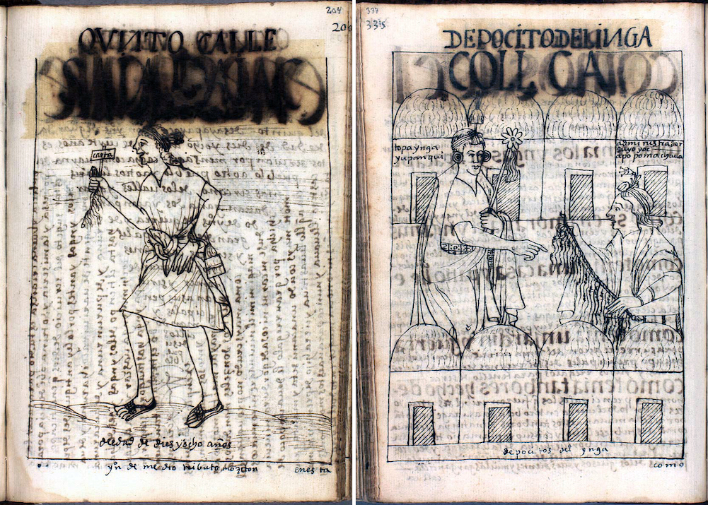
An Inka messenger carries a khipu in his hand (left), and a khipukamayoq and Inka ruler in front of storehouses (right), from Felipe Guaman Poma de Ayala, The First New Chronicle and Good Government (or El primer nueva corónica y buen gobierno), c. 1615, p. 202 [204] and p. 335 [337] (The Royal Danish Library, Copenhagen)
Khipukamayoq purportedly held the khipu code as a secret. Spanish chroniclers often described khipukamayoq as a special title passed from father to son. The chroniclers also described a system of governance in which official khipu records were produced in duplicate, with an archived copy sent to the capital of Cuzco. Drawings by the Indigenous writer Felipe Guaman Poma de Ayala from the early 1600s show messengers carrying rolled up khipu across the Andes, and bureaucrats reading khipu accounts before imperial storehouses.
A woven Inka bag, inside which was found a fragmented khipu and loose pendant strings. This bag and its contents were recovered near modern Lima, Peru, as part of a group of mortuary goods likely belonging to an Inka bureaucrat (Logan Museum of Anthropology, Beloit College)
The future of the khipu
More than 600 khipus have been catalogued in detail for visual and statistical comparisons. The majority are found in museum and private collections, which means many have been separated from their original archaeological contexts. Archaeological khipus are not likely to survive in high-altitude regions, like the Inka capital of Cuzco in the high Andes, where organic fibers rarely survive within the earth. This presents another challenge to deciphering khipus.
However, khipus are not only found within the earth of archaeological sites or in art collections; they are still used in Andean communities today. The Indigenous descendants of the Inkas and the peoples they governed continue to live in the Andes. In the last 500 years since the Spanish invasion, khipus have been used to count flocks of animals and to track offerings and payments related to Catholic Masses and festivals. In some places, khipus have been created to accompany deceased loved ones into the afterlife. This tradition had been in decline, but resurged with the COVID-19 pandemic. Practitioners believe that the khipu animates the dead, and the rebirth of this tradition has brought comfort amid the grief of so much sudden loss.
Khipu makers may explain their ways of writing today, but those ways do not translate well for reading the Inkas’ khipus. As khipus seem to have been key for managing a geographically large and extraordinarily diverse population of millions of people speaking multiple languages, determining how they functioned is essential if we want to understand the Inka empire.
Source: Dr. Kylie E. Quave, “The Inka khipu,” in Smarthistory, January 20, 2022, accessed August 16, 2024, https://smarthistory.org/inka-khipu/.
ARCHITECTURE
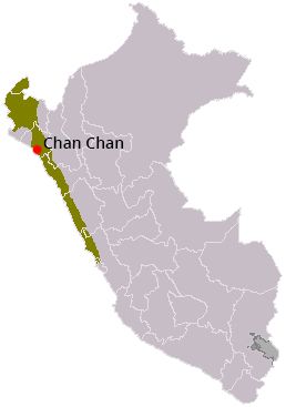
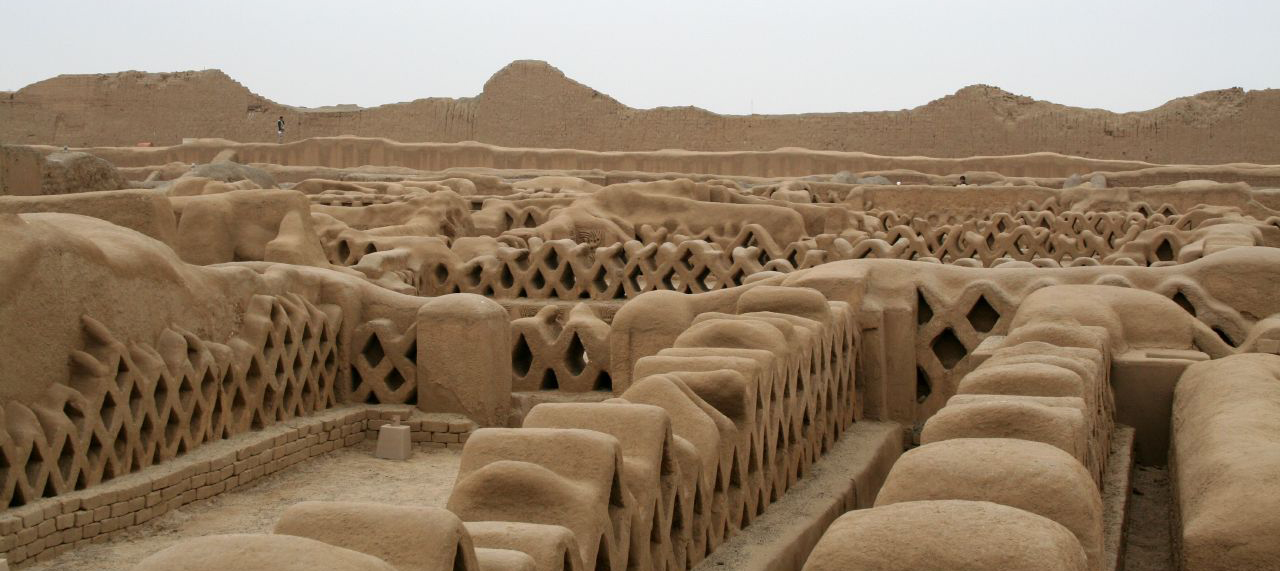
Chan Chan – Chimu Culture
by UNESCO
The Chimu Kingdom, with Chan Chan as its capital, reached its apogee in the 15th century, not long before falling to the Incas. The planning of this huge city, the largest in pre-Columbian America, reflects a strict political and social strategy, marked by the city’s division into nine ‘citadels’ or ‘palaces’ forming autonomous units.
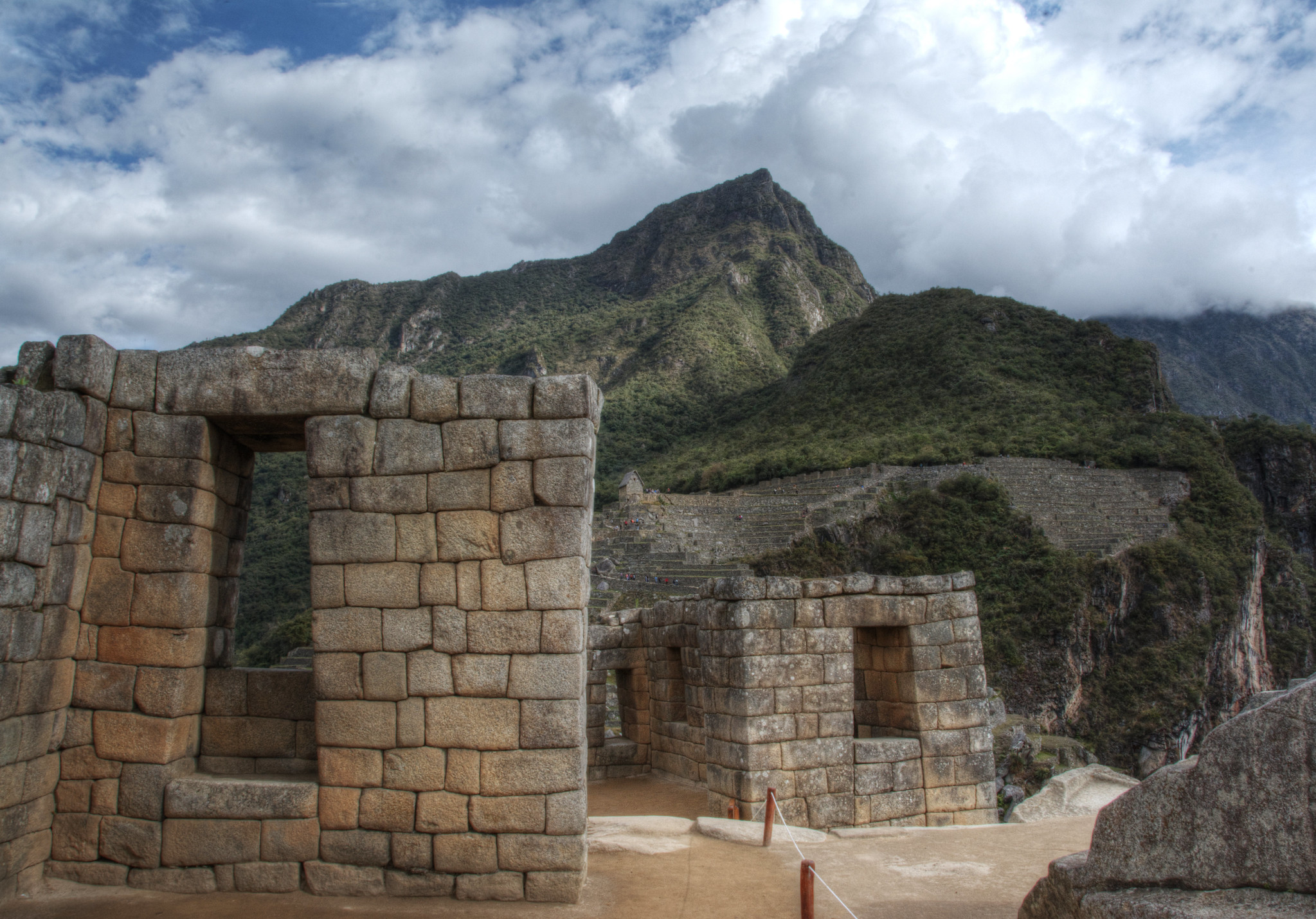
At the breath-taking elevation of 11,200 feet (roughly 3,400 m), the city of Cuzco was not just the capital of Tawantinsuyu (“Land of the Four Quarters,” the Inka name for their empire in their native language, Quechua). It was an axis mundi—the center of existence—and a reflection of Inka power. The city was divided into two sections, hanan (upper or high) and hurin (lower), which paralleled the social organization of Inka society into upper and lower moieties (social divisions). Cuzco was further divided into quarters that reflected the four divisions of the empire, and people from those sections inhabited their respective quarters of the city. In this way, the city was a map in miniature of the entire Inka empire, and a way for the Inka rulers to explicitly display their power to shape and order that empire. Some scholars think that the city was deliberately laid out so that it was shaped like a puma, symbol of Inka might, but this is still under debate.
Twelve-sided stone, Cuzco, c. 1440–1540 (photo: Howard G Charing, CC BY-NC 2.0)
The masonry of Cuzco displays an understanding of stones as being like people, in that many different ones may fit together if they are properly organized. Each individual stone was pecked with tools and fitted to the one next to it, with the result that blocks will have a varied number of sides, such as the famous Twelve-Sided stone in the walls of Hatun Rumiyoq Street. Some sides of each stone were made to curve outward slightly, others to be slightly concave, so that the stones slotted together, while still allowing a small amount of movement. The ability to move a little was important in an area that is seismically active, protecting the walls from earthquakes.
The city hummed with activity, both secular and religious. Not only the Inka rulers and their nobles resided in Cuzco. Local leaders from all sections of the empire also lived in Cuzco—often compelled to do so as a means of controlling their home populations. Girls and young women were drawn from across the empire to the capital to serve as cloistered acllas (“chosen women”): to weave fine cloth for gods and nobles and to make corn beer (chicha) for religious rituals, to serve gods in shrines, and in some cases to be given to Inka favorites in marriage. Young men were also brought to Cuzco to be educated and raised in the Inka culture. When they returned to their homes, they would be valuable advocates for Inka traditions and power. In addition to the Inka gods and ancestor mummies kept in the capital, there were also the captured gods of subject peoples, brought there as another means of controlling their followers.
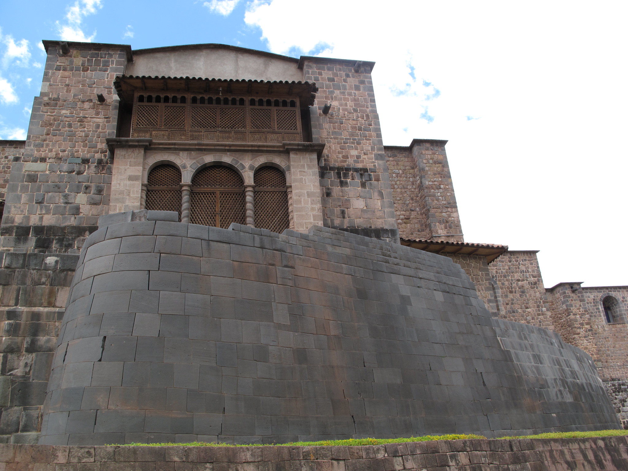
Remains of the Qorikancha, Inka masonry below Spanish colonial construction of the church and monastery of Santo Domingo, Cuzco, Peru, c. 1440 (photo: Angela Rutherford, CC BY-NC-ND 2.0)
Qorikancha
At the heart of hurin Cuzco was the Qorikancha (“Golden House”), the most sacred shrine of the Inka, dedicated to the worship of the sun. While the Inka had many gods, they claimed descent from the sun, whom they called Inti, and held the sun’s worship above all others. The Qorikancha was the center point of the empire, and from it radiated imaginary lines, called ceques, which connected it to shrines throughout the Cuzco valley. Rebecca Stone refers to the ceques as a “landscape calendar and cosmogram,” as the shrines were also a marker of time, with different noble families tending to and holding rituals at the shrines around the ceque system throughout the year.
After the conquest, the Qorikancha was one of many Inka shrines turned into a Christian holy space. The monastery and church of Santo Domingo were built around and on top of the original shrine, incorporating the old structure into the new one in a way that makes for a strange appearance today. Parts of the old temple are still visible, inside and out, alternating with Spanish Baroque architectural features (see image above).
The Qorikancha itself was renovated by the first emperor, Pachacuti Inka Yupanqui, after he had a mystical revelation that declared him a divine king. All of the doorways, windows, and wall niches of the Qorikancha were the distinctive Inka trapezoid shape, with doorways double-jambed (see image below) to signify the importance of the building.
Double-jambed door, Qorikancha, Cuzco, c. 1440–1540 (photo: Sarahh Scher, CC BY-NC-SA 2.0)
The exceptionally fine masonry of the Qorikancha was reserved for the most important buildings, since it was even more time-consuming than regular Inka stonework.
Rather than fitting each stone together as an individual shape, creating an irregular-looking surface, here they were shaped into even courses of rectangular blocks, and polished to a smooth finish. The walls were then covered in sheets of gold to signify the shrine’s dedication to Inti, and would have reflected the sun’s rays with a blinding brilliance. But the spectacular, radiant exterior was not the apex of the building’s wonders. Inside, a reproduction of the world in miniature took the shape of a garden made from gold, silver and jewels, with people, animals, and plants. The riches of the Qorikancha would be taken in the looting of the city following the Spanish conquest in 1532, and melted down for their precious materials.
Saqsa Wayman
Saqsa Wayman, Cuzco, Peru, c. 1440–1540 (photo: Sarahh Scher, CC BY-NC-SA 2.0)
After the conquest, the Qorikancha was one of many Inka shrines turned into a Christian holy space. The monastery and church of Santo Domingo were built around and on top of the original shrine, incorporating the old structure into the new one in a way that makes for a strange appearance today. Parts of the old temple are still visible, inside and out, alternating with Spanish Baroque architectural features (see image above).
The Qorikancha itself was renovated by the first emperor, Pachacuti Inka Yupanqui, after he had a mystical revelation that declared him a divine king. All of the doorways, windows, and wall niches of the Qorikancha were the distinctive Inka trapezoid shape, with doorways double-jambed (see image below) to signify the importance of the building.ular Inka stonework.
Rather than fitting each stone together as an individual shape, creating an irregular-looking surface, here they were shaped into even courses of rectangular blocks, and polished to a smooth finish. The walls were then covered in sheets of gold to signify the shrine’s dedication to Inti, and would have reflected the sun’s rays with a blinding brilliance. But the spectacular, radiant exterior was not the apex of the building’s wonders. Inside, a reproduction of the world in miniature took the shape of a garden made from gold, silver and jewels, with people, animals, and plants. The riches of the Qorikancha would be taken in the looting of the city following the Spanish conquest in 1532, and melted down for their precious materials.
Saqsa Wayman
Saqsa Wayman, Cuzco, Peru, c. 1440-1540 (photo: Sarahh Scher, CC BY-NC-SA 2.0)
Saqsa Wayman looks down on the city of Cuzco from the northwest. The structure, with its zig-zagging walls, is described as a fortress, although there are still many questions as to how it functioned in that capacity, and the purpose of some of its features is debated. It is possible that it was never finished, or that parts of it were left incomplete at the time of conquest, as Jean-Pierre Protzen has proposed. The stones used to construct it were much larger than those used in the streets and houses of Cuzco, as can be seen in the photo at left. The stones were quarried and hauled into place using considerable manpower, obtained through the mit’a, or labor tax, that all able-bodied people of the empire owed the Inka.
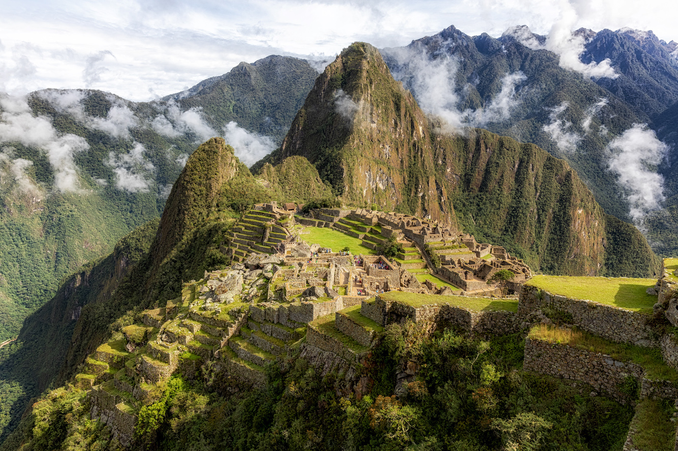
Machu Picchu, Peru, c. 1450–1540 (photo: Matthew Paulson, CC BY-NC-ND 2.0)
A royal estate
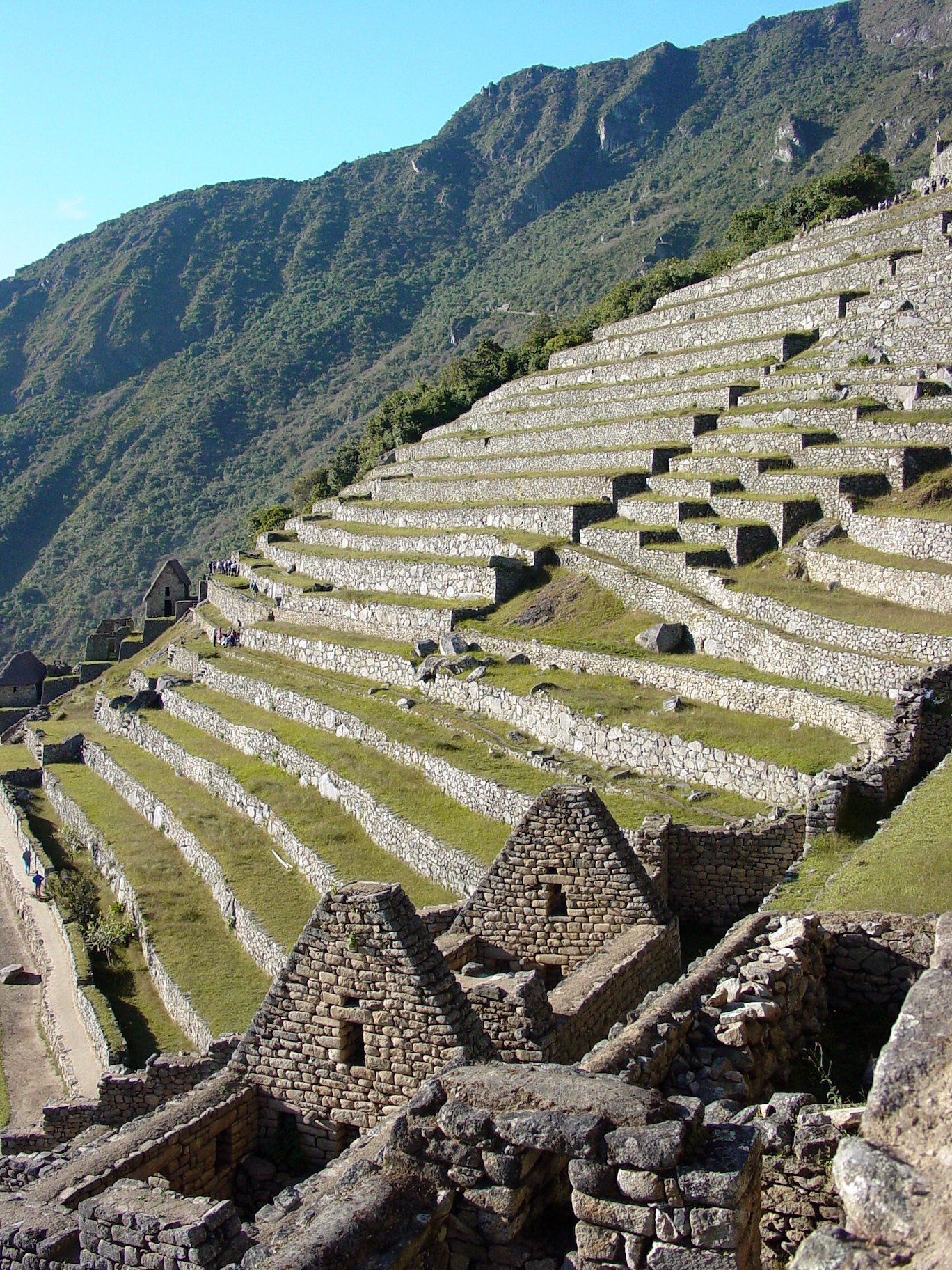
Stone terracing, Machu Picchu, Peru, c. 1450–1540 (photo: Adam Jones, CC BY 2.0)
Machu Picchu is often described as “mysterious,” but in fact a great deal is known about its construction and purpose. It was built as a royal estate for the first Inka emperor, Pachacuti Inka Yupanqui, in the middle of the 15th century, on a mountain saddle overlooking the Urubamba River (in modern day Peru). The location was approximately three days’ walk from the Inka capital of Cusco, and nearly 3,000 feet lower in elevation (7,972 feet / 2,430 meters), with a pleasant climate. It was intended as a place where the Inka emperor and his family could host feasts, perform religious ceremonies, and administer the affairs of empire, while also establishing a claim to land that would be owned by his lineage after his death. The site was chosen and situated for its relationship to the Andean landscape, including sight lines to other mountain peaks, called apus, which have long been considered ancestral deities throughout the Andes. The site contains housing for elites, retainers, and maintenance staff, religious shrines, fountains, and terraces, as well as carved rock outcrops, a signature element of Inka art.
Architecture
The site features architecture, from houses to terraces, built by carefully fitting individual stones against each other. Terraces were a common element of highland agriculture long before the Inka. They increased the arable land surface and reduced erosion by creating walled steps down the sides of steep mountains. Each step could then be planted with crops. Terracing took advantage of the landscape and provided some sustenance for the emperor and his entourage during his visits, as well as producing ritually-important maize crops. Further provisions came from the rich lands at the foot of the mountain peak, which were also beholden to Pachacuti and his family.
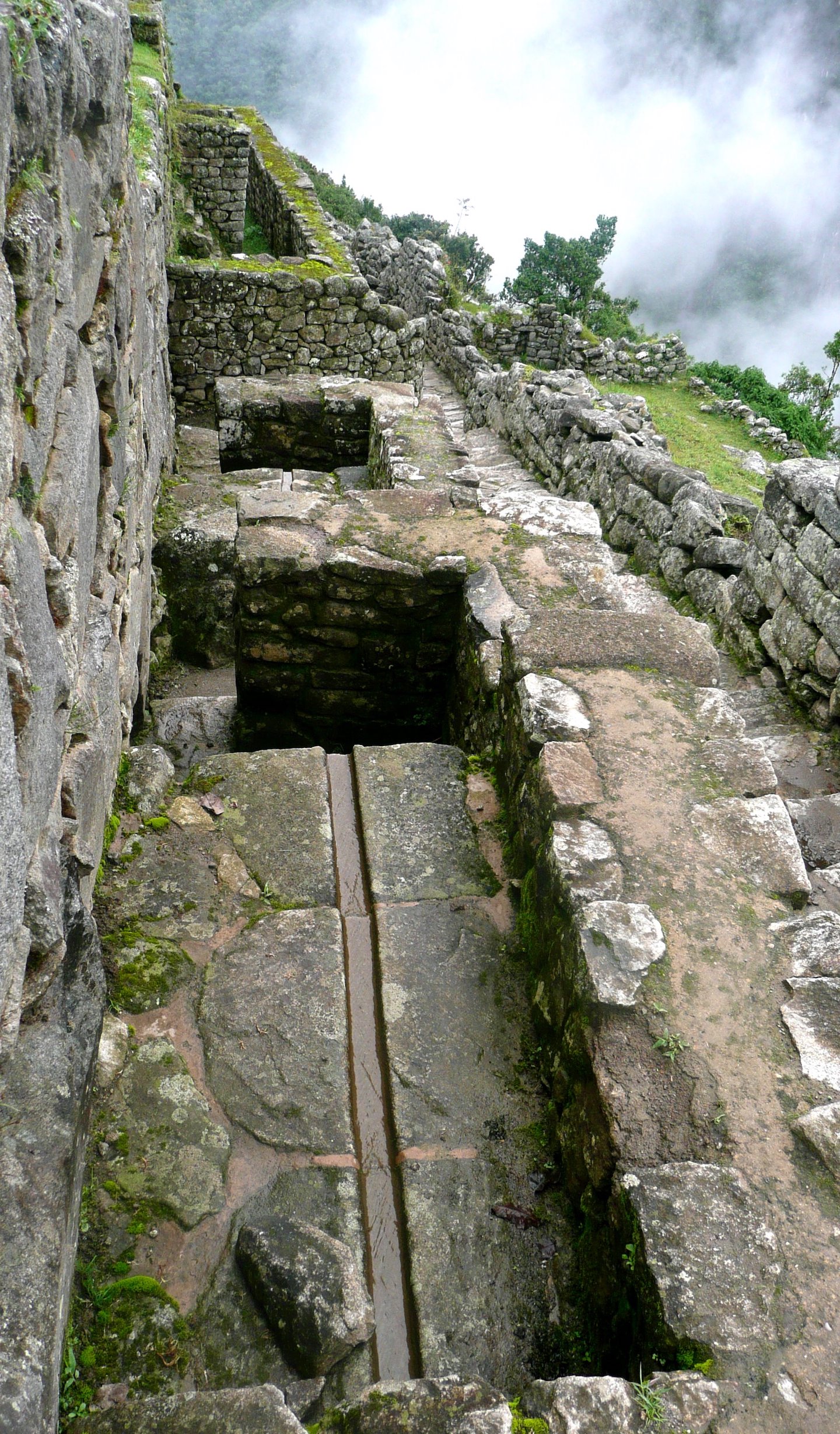
Stone channel drain, Machu Picchu, Peru, c. 1450–1540 (photo: Eduardo Zárate, CC BY-ND 2.0)
Water management at the site was crucial, and throughout Machu Picchu a system of stone channels drains water from rainfall and from a spring near the site. Some of the water was channelled to stone fountains. There are sixteen in all, descending in elevation through the site. The first in the series is placed outside the door of the emperor’s compound. That fountain is constructed with walls that may have created a ritual bath for the emperor, connected to his duties as a sacred king who performed religious rituals.
The construction of the main buildings is typical of Inka elite architecture. The walls were built of stones that had been individually shaped to fit closely with one another, rather than being shaped into similar units. This was accomplished by a laborious process of pecking at the stones with tools, gradually shaping them so that each stone was uniquely nested against those around it. Each stone had some sides that protruded slightly, and some with slight concave faces, socketing the stones so that they held together, but allowed for earthquake-damping movement in this seismically active region. Outward faces were then worked smooth, so that the walls resemble an intricate mosaic. Most structures were roofed with wood and thatch. Entryways were in the unique Inka shape of a trapezoid, rather than a rectangle. The trapezoid shape was also used for niches and windows in the walls of buildings. Buildings for people or activities of lower status were made using a rough construction technique that did not take the time to shape the stones.
Stone walls and trapezoid-shaped windows, Machu Picchu, Peru, c. 1450–1540 (photo: Cocoabiscuit, CC BY-NC-ND 2.0)
Population and social dynamics
The emperor and his retinue would only reside at Machu Picchu for part of the year. Most of the people who lived there permanently were yanaconas (retainers) and mitimaes (colonists obligated to move to their location). Graves at Machu Picchu have yielded evidence that many of the yanaconas there were craftspeople, including metalsmiths, who came from all over the empire. The ability to command people across the empire and to oblige them to work for the Inka nobility was an expression of imperial power. The buildings of Machu Picchu clearly show the social divisions of the site, with most of the high-status residential buildings in a cluster to the northeast. The emperor himself lived in a separate compound at the southwest of the site, indicating his unique status as the ruler. The observatory was adjacent to the royal residence, emphasizing the relationship between the elites, religious ritual, and astronomical observation, including Pachacuti’s claim as both a descendant of the sun (whom the Inka called Inti) and the sun himself.
Observatory seen from above, Machu Picchu, Peru, c. 1450–1540 (photo: Brian Jeffery Beggerly, CC BY 2.0)
One of the obligations of the royal family was performing rituals that sustained relationships with the supernatural forces that drove existence. The number of religious structures at Machu Picchu is high, indicating that Pachacuti and his lineage were heavily involved in the religious functioning of the empire, a task that underscored his right to rule.
Observatory
Also called the Temple of the Sun, this building’s purpose is echoed in its unique shape. It is composed of two main parts: an upper curved stone enclosure with windows and niches placed in it, and a cave beneath this structure with masonry additions that hold more niches. Modifications of the windows in the Observatory’s upper walls indicate that they were used to calculate the June solstice, as well as the first morning rise of the constellation Pleiades and other important constellations. The cave beneath the enclosure may refer to the place of the underworld in Inka myth, making the Observatory a building that embodied cosmological thought as much as it facilitated astronomical observation.
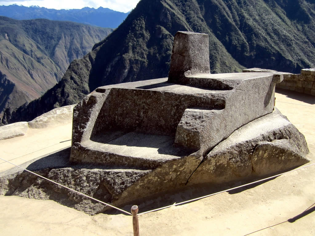
Intihuatana, Machu Picchu, Peru, c. 1450–1540 (photo: David Stanley, CC BY 2.0)
Intihuatana
The Intihuatana (“hitching post of the sun”) is a carved boulder located in the ritual area of the site, to the west of the main plaza. Carved boulders were a part of the Inka relationship with the earth, and expressions of belief in a landscape inhabited by supernatural forces. Carved boulders of this type are found throughout the heart of the Inka empire. The stone’s name refers to the idea that it was used to track the passage of the sun throughout the year, part of the reckoning of time used to determine when religious events would take place and similar to the Observatory.
Backstory
Due to its status as an important piece of both global and Peruvian heritage, Machu Picchu has recently become the focus of international attention with regard to both the repatriation of artifacts from the site, and preservation of the existing structures against environmental and human impact.
Covered by jungle and known only to locals since the sixteenth century, Machu Picchu was uncovered by Hiram Bingham III, a professor of South American history at Yale University, in 1911. In addition to the structures at the site, he and his team excavated thousands of artifacts, including ceramics, tools, jewelry and human bones, which he brought back to Yale under an agreement with the Peruvian government at the time. The agreement stipulated that the artifacts could be studied at Yale, with the provision that they could be requested and returned to Peru at any time. Since then, most of the objects have been housed at Yale’s Peabody Museum.
Despite Peru’s repeated demands for the objects’ return over the last century, it took a U.S. federal court case and the intervention of Peru’s president to finally secure their repatriation in 2010. [1] According to the Peabody museum website,
In a gesture of friendship and in recognition of the unique place that Machu Picchu has come to hold for the people of Cusco and the Peruvian nation, [Yale University] has decided to return to Peru the pieces that were excavated by Hiram Bingham III at Machu Picchu that have been conserved and maintained in the Peabody Museum of Natural History at Yale University for the last century.
[2]
The agreement has resulted in ongoing research cooperation between Yale and UNSAAC, and is an example of how repatriation efforts can lead to new and fruitful opportunities for cooperation.
The site of Machu Picchu itself is also now the focus of governmental efforts, as authorities attempt to cope with the great numbers of visitors and their impact on the site, in addition to environmental and agricultural factors that threaten the integrity of the landscape. According to the UNESCO website,
the Historic Sanctuary of Machu Picchu is among the greatest artistic, architectural and land use achievements anywhere and the most significant tangible legacy of the Inca civilization.…The strongly increasing number of visitors to the Historic Sanctuary of Machu Picchu must be matched by an adequate management regulating access.…The planning and organization of transportation and infrastructure construction, as well as the sanitary and safety conditions for both tourists and new residents attracted by tourism requires the creation of high quality and new long-term solutions, and is a significant ongoing concern.[3]
The government of Peru recently instituted a ticketing system that caps the number of visitors and requires them reserve and pay for daily time slots at the site. [4] Still, UNESCO warns that
Since the time of inscription consistent concerns have been expressed about ecosystem degradation through logging, firewood and commercial plant collection, poor waste management, poaching, agricultural encroachment…, introduced species and water pollution …, in addition from pressures derived from broader development in the region… Continuous efforts are needed to comply with protected areas and other legislation and plans and prevent further degradation.[5]
Given the number of agencies involved in planning and protecting Machu Picchu, UNESCO states, achieving an adequate master plan for the site is an ongoing challenge. Machu Picchu is only one of many such world heritage sites around the world that are dealing with the threats brought by increased visitation, and it points to the tensions between the need for everyone to enjoy and benefit from the experience of seeing these magnificent sites, and the need to preserve them for future generations.
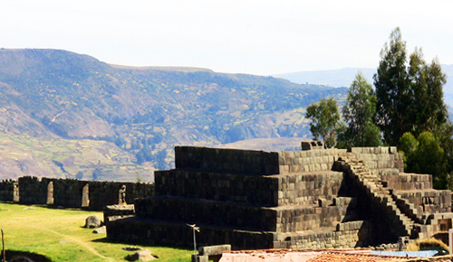
The Inka capital Cusco and principal outlying towns of the Inka Empire were organized around a public plaza with a specially-constructed platform placed facing a designated sacred central space called the ushnu. This sacred space was marked by a vertical opening into the body of the earth into which liquid and other offerings were made.
The ushnu platform was therefore a kind of stage from which the Inka king and his lords could observe and rule over an annual round of seasonal festivals and ceremonial events.
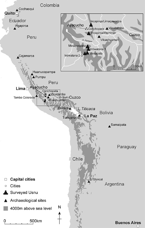
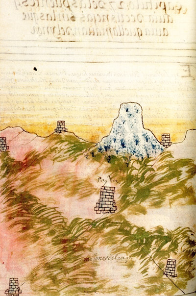
In the late 1990s archaeologists in Ecuador, Peru, Bolivia, Chile and Argentina began mapping the full system of Inka roads, including many of the less accessible, secondary trails at high altitude. In Peru this survey soon revealed a previously unrecognized category of stone platform with typically distinctive Inka stonework. These structures are carefully positioned on isolated mountain-tops 4000–4800 meters above sea level and represent some of the highest dressed-stone architecture found anywhere in the Americas, and possibly in the world. These structures were clearly important in Inka political and sacred geography and had profound symbolic significance.
A well-known ushnu site, Vilcashuamán was a major Inka administrative centre on the main Inka road running along the Andes mountain chain and down to the coast.
The sites were selected to command unsurpassed views of the snow-capped mountain peaks, worshipped as wamanis, or mountain deities, by the local communities. In this way local deities were incorporated into the overarching Inka state religion. The Inkas used the platforms as potent symbols of religious and political authority. They served as an innovative and powerful new instrument of statecraft in order both to define and proclaim their growing imperial hegemony.
Atahualpa, the Inka ruler taken and killed by Spanish invaders in the 1500s, asked for the meeting with his murderers to take place in the great plaza of the town of Cajamarca at the site of a “castillejo,” a type of platform we now call an ushnu. This shows not only that ushnus were appropriate sites to meet strangers, but that they were considered to hold great significance.
Research at 30 platforms across the modern area of Ayacucho has demonstrated that ushnus are located in both town squares and alongside Inka roads. In towns, the platforms are located in or by the side of the main square, while those located on Inka roads are often found on mountain tops. There, they offer views of the horizon and of Wamanis (mountain deities) in the landscape.
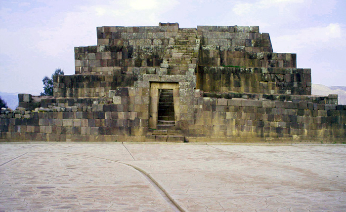
The major ushnu platform at Vilcashuamán, which has been extensively restored comprises four superimposed platforms with a staircase of 36 steps on its eastern side, which, through a gateway, allows access to the top. The staircase is built up against the structure, abutting it. The top platform on its west side has a ramp allowing access to the platform below. On top the platform has a large monolithic seat carved to accommodate two people.
On its eastern side two squarish structures are built up close to the bottom platform; beyond this are the remains of a large kallanka or great hall and it is likely there was a second one of these across an open space. Slightly further to the west is the town’s cemetery.
To the east and north-east is the main colonial plaza and to the north-east are extensive elaborate Inka remains including what have been identified as the footings of the local temples of the sun and moon. The fields surrounding the town are extensively dedicated to growing maize, barley and oats.
Chancay Standing Female Figure, 1200–1450, ceramic, 18 1/4 x 11 3/4 x 5 inches (Michael C. Carlos Museum)
What can small-scale ceramic figurines tell us about the past? It turns out, they can tell us a great deal about cultures that no longer exist. A wonderful example is a Chancay female figure from 1200–1450.
The Chancay people lived on the central coast of Peru, centered on the Chancay river valley (approximately 80 kilometers north of Lima) from c. 1000 C.E. until their conquest by the Chimú and then the Inka in the fifteenth century. They were expert weavers, creating fine cloth as well as fiber sculptures, but they also created ceramic sculptures in a distinctive style. Among them are standing figures of both men and women, painted in a brown-black over a creamy white slip.
The Standing Female Figure is relatively large (over eighteen inches tall), hollow, and likely made by joining slabs of clay together, although molds could have been part of that process. The surface of the figure is painted with a white slip that was then overpainted with brown-black slip designs. The abstracted body is characterized by a large head, wide torso, and long, large legs with big feet that help to hold the sculpture upright. The small arms are relatively flat, with a bend at the elbow and paddle-like hands.
Her facial features are small compared to the overall head, with oval eyes, a sharply triangular nose, and a small mouth that is partially obscured by the decorative pattern on her chin that is made up of two serrated lines (this is actually an animal mouth painted over her actual mouth, as discussed below). Her face and head are in fact painted with a number of patterns made up of lines with a consistent thickness.
A woman…
At the top of her head, vertical lines delineate sections that are filled with a shape reminiscent of a step or mountain range. A design similar to this is found in most ancient Andean visual vocabularies, especially in textiles. Beneath that, a band with a more complex pattern features white circles outlined in black, with a black dot at the center. These circles fit into triangular shapes, alternating point up and point down, with a space in between decorated with curved and straight lines. This may be meant to indicate a textile headband, but the design does not wrap around the back of the head the way the design on the torso does. The corners of her eyes are linked to the bottom of the band by two thin lines set at a diagonal, with more dotted circles in between the lines and curves fringing the outer edges.
Chancay Standing Female Figure, 1200–1450, ceramic, 18 1/4 x 11 3/4 x 5 inches (Michael C. Carlos Museum)
While the figure at first appears to be wearing a patterned tunic and nude from the waist down, the decoration on her torso is probably intended to represent body paint or tattooing. It consists of a black background, a frame-like border made up of two white lines, and white spots, some of which have a pattern in the center made up of two crossed lines and four dots. Two of the spots that do not have the central pattern actually surround small bumps that indicate breasts.
While not visible in the photographs, there is a faint impression of a textile on the sculpture that indicates that this figure was originally meant to be dressed, further indicating that the torso patterning is body decoration. The holes across the top of the head indicate that along with her dress, she would have been adorned with perhaps a feather headdress or other head ornament.
…and something else
The decoration of the body paint on the standing figure’s torso may just look like irregular splotches of white on a dark background, but Dr. Rebecca Stone has noted that the spots, along with the wide, toothy mouth painted over her actual mouth, likely reference the whale shark. Stone has also pointed out that the white strip down the back of the figure’s torso echoes the white line of dots that can highlight the edge of the shark’s dorsal fin. The whale shark is the largest living species of fish, with an average length of 32 feet and weight of 20,000 pounds. Their mouths can be up to 4.9 feet wide, and are filled with tiny teeth and filters for feeding on plankton and very small fish. As they are not predators, their attitude towards humans has historically been one of docile indifference.
Whale shark in frontal view (photo: Derek Keats, CC BY 2.0)
Chancay Standing Female Figure, detail, 1200–1450, ceramic, 18 1/4 x 11 3/4 x 5 inches (Michael C. Carlos Museum)
These whale shark attributes, layered over her human body, could be indications that this figure is being depicted as a ritual specialist transforming into a spiritual alter ego to travel into the spirit world, and whose animal self is the whale shark. While the whale shark is not a fierce predator like a jaguar, harpy eagle, or caiman — apex predators that are commonly associated with ritual transformation in Andean art — they are formidable in size, and are able to move from the surface of the water to depths of several thousand feet, which may have been thought of as an ability to travel between this world and the underworld, just as ritual specialists could travel between this world and the next. It is also possible that the woman’s body paint marks her as a member of a clan or other lineage group associated with the whale shark, perhaps claiming it as an ancestor.
Profile view of a whale shark (photo: Shiyam ElkCloner, CC BY-SA 3.0)
Female whale sharks can produce large litters of pups, perhaps also linking them with fertility in the minds of the Chancay people, and making this the spiritual power that the whale shark (as spiritual alter ego or as lineage ancestor) was thought to wield. Her wide, staring eyes may allude to trance or spiritual sight (the ability to see into the spirit world), but they also dovetail with the whale shark’s ability to roll its eyes back and pull them into its head, which must have made a strong impression on the Chancay people who witnessed it. The blending of human and animal traits in this figure shows us that the Chancay people were keen observers of nature, and that their beliefs were combined with what they knew about the natural world.
Wall of the main plaza of the ciudadela Nik An in Chan Chan, capitol of Chimor, Peru, c. 950-1470 (photo: Kevstan, CC BY-SA 3.0)
Map of the Chimor kingdom at its largest extent (Huhsunqu, CC BY-SA 2.5)
Following the decline of the Moche on the north coast of Peru, there arose two cultures in their place. One was the Sicán (or Lambayeque), beginning around 750 in the northern part of the old Moche territory in the Lambayeque and La Leche river valleys. The other was the Chimú, who began to flourish around 950 in the Moche valley (around the Moche River) and spread both north and south, eventually conquering the Sicán around 1375 and expanding almost as far as Lima. The Chimú kingdom, called Chimor, came to a close with their conquest by the Inka.
The capital of the Kingdom of Chimor was the city of Chan Chan, located in the Moche river valley, closer to the coast than the Moche culture’s center at the Huacas del Sol and de la Luna. Chan Chan was composed of royal compounds, today referred to as ciudadelas or citadels. These citadels were elaborate, labyrinthine compounds surrounded by high walls made of adobe bricks covered in mud plaster and reliefs.
View of the ruins of adobe walls in ciudadela Nik An, Chan Chan, capital of Chimor, Peru (photo: Veronique Debord, CC BY-SA 2.0)
Ciudadelas were composed of long, narrow corridors leading to spaces with different uses, such as large, open plazas with central platforms for ceremonies, storage facilities, and even large wells. It would be difficult for someone unfamiliar with the citadel to navigate their way through, and so the architectural design provided a kind of security in addition to the presence of guards and court officials.
The citadel was a royal household, audience chamber, and storage facility during the life of the king, and his tomb upon his death. Each new king would build a new citadel, as the old king was buried in his. A new king would begin from square one, needing to build his wealth and his citadel, along with his reputation. This may have been one reason for the steady expansion of the kingdom of Chimor: the need for new sources of wealth for new kings.
Spondylus princeps shell (photo: Kevin Walsh, CC BY 2.0)
Chimú kings had access to high-quality textiles made with dyed camelid wool, gold- and silversmiths who made fantastical jewelry as well as delightful miniatures of everyday objects, and exotic feathers and shells. The feathers came from the cloud forests of the Andes as well as the Amazonian jungles that lay beyond, and Spondylus shells were brought from the warm waters of modern-day coastal Ecuador. The king of Chimor had in his retinue a servant called the Fonga Sigde, whose job it was to strew crushed Spondylus powder before the king as he walked, creating a “red carpet” for him to walk on and showing his extreme wealth and power.
Because of the legendary wealth of the kings of Chimor, the cuidadelas of Chan Chan were mercilessly looted beginning with the fall of the Chimú empire to the Inka around 1470, and very few objects have been recovered scientifically from the site. There is, however, a great deal of conservation and restoration work going on at the site, and other sites have yielded a wealth of Chimú objects, including the Moche pyramids of Huaca del Sol and Huaca de la Luna, which are less than three miles away. The Chimú may have seen these structures as belonging to revered ancestors, and therefore spiritually powerful and an appropriate place for their own dead.
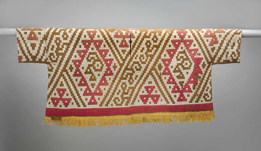
Chimú tunic with fringed hem and bird design, 1300–1470, Peru, camelid fiber, cotton, 49.5 x 113 cm (The Metropolitan Museum of Art)
Clothed in glory
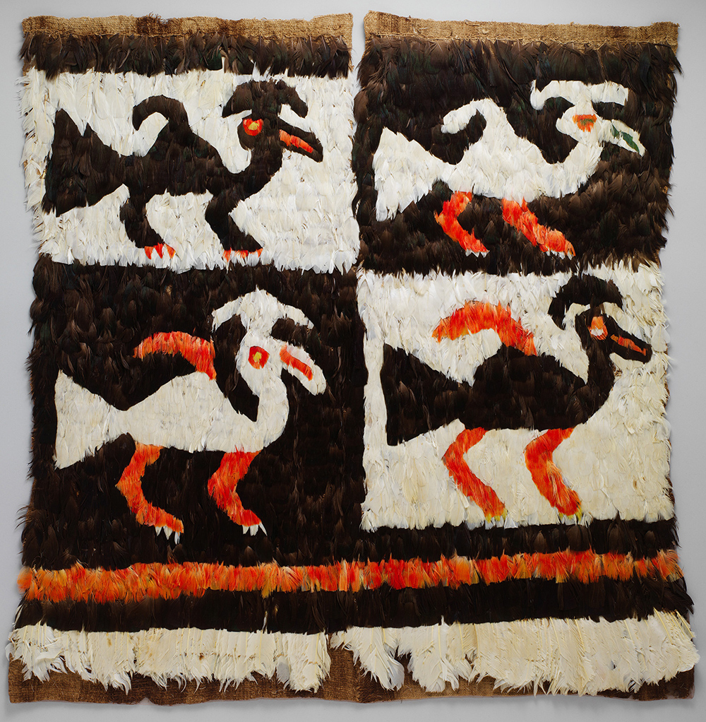
Chimú feathered tunic, 15th–early 17th century, Peru, cotton, feathers, 69.9 × 68.6 cm (The Metropolitan Museum of Art)
Chimú tunics varied in quality from plain, undyed cotton in natural colors to brilliantly-colored dyed camelid wool, (above) and eye-catching, exotic feathered tunics (left). Both of the tunics shown here feature bird designs, but the one above is heavily abstracted. The bird can be seen inside the large pink diamond shapes, reduced mainly to a large beak, round head with its eye, and two triangles for the body and tail. Heavily geometric designs like this one were common in Chimú textiles, although some are more naturalistic. The feathered tunic’s birds are easier to see. They were created by carefully tying rows of trimmed feathers to a plain textile backing. Despite their relative clarity, they are still similar in shape to those in the textile tunic. The plainest textiles would have been worn by the common people, with more elaborate creations like the ones seen here worn by the elites. The king was entitled to wear the most luxurious articles of clothing, distinguishing him from everyone else.
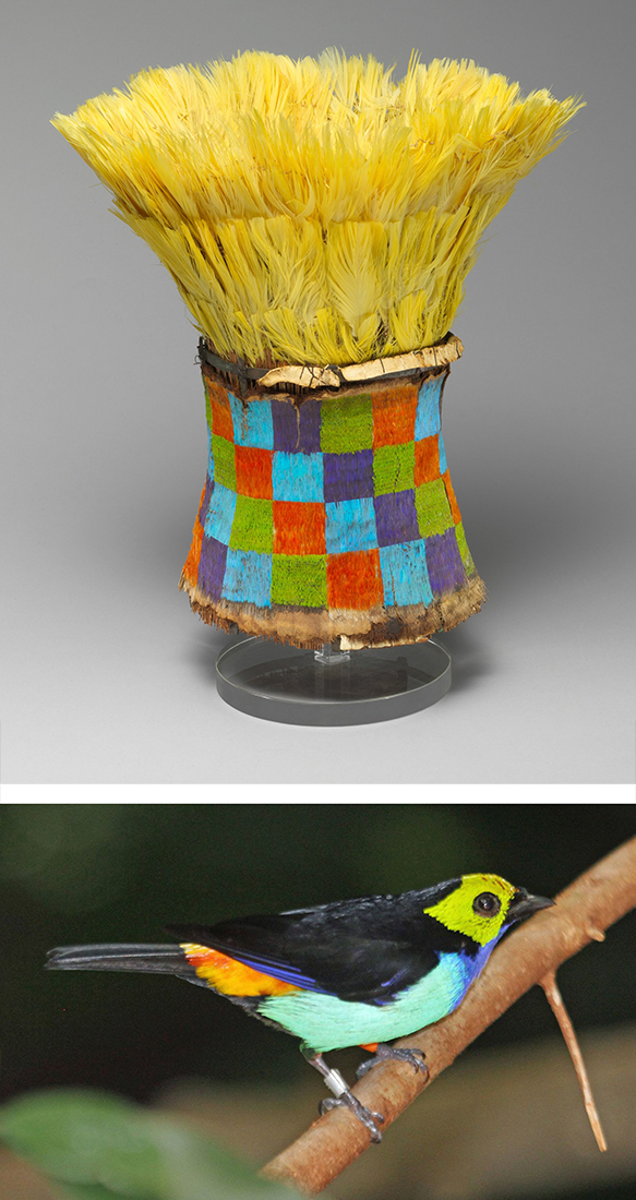
Top: Chimú feathered crown, 14th–15th century, Peru, paradise tanager and macaw feathers, cotton, skin, cane, copper, 26 cm high (The Metropolitan Museum of Art) Bottom: Paradise tanager (photo: DickDaniels, CC BY-SA 4.0)
Feathers were also used to decorate crowns. The conical shape would be constructed of a basketry base, then decorated with feathers and other ornaments (in this case with copper bands at the top and bottom of the base). Art historians have identified the feathers as coming from the paradise tanager and the macaw, both birds that live in the dense tropical jungles to the east of the Andes mountains. The brilliant colors and exotic origins of the feathers signaled the ruler’s ability to procure luxury items from far away.
Pots that whistle
Chimú ceramics are very different from those of the Moche that preceded them. They are less sophisticated in execution, and usually are not painted, relying solely on modeled form and surface textures for their decoration.
The vessel below is a double chamber type that is common to Chimú, where two hollow forms are joined by a tube at the bottom and a strap handle at the top, with a more or less cylindrical spout sticking straight up from one chamber. In some cases, the vessel has been engineered so that pouring liquid out of it or sloshing the liquid around inside it will force air through a whistle inside one chamber, causing the pot to make a sound when it is used(audio of this vessel whistling can be found here). These vessels were fired in a kiln deprived of oxygen (referred to as a “reducing atmosphere”), causing the iron compounds in the clay to turn black. The general term for Andean ceramics made this way is “blackware.”
Chimú whistling jar, 1000–1476, Peru, mold-form clay, 16 x 9.5 cm (The Metropolitan Museum of Art)
Glittering regalia
Chimú metalsmiths made many different kinds of objects. The earspools seen below would have been worn by a ruler or very high-ranking noble. They depict a man, probably a king, holding a beaker and a feather fan, carried on a litter by other figures. He wears a large headdress topped with a broad crescent of feathers, with a stepped ornament at the center. He wears earspools and a tunic with a fringed hem. Trapezoidal sequins dangle from wire loops on the surface of the earring, and would have shimmered as the wearer moved, adding further splendor to the object.
Pair of Chimú earspools, 12th–15th century, Peru, gold, 13.5 cm in diameter (The Metropolitan Museum of Art)
Left: Chimú beaker, 14th–15th century, Peru, silver, 19.7 x 13.3 cm (The Metropolitan Museum of Art) Right: Miniature panpipes, 13th–15th century, Peru, silver, 2.7 x 5.6cm (The Metropolitan Museum of Art)
Metalsmiths also made silver and gold beakers, similar to those made by the Sicán. The figure in the beaker seen here holds a tunic with a bird design. The Chimú also made miniature metal versions of objects—household goods, musical instruments, even fruits. The tiny (2.7 x 5.6 cm!) panpipes to the right would have been included in a tomb as a precious, more durable version of an instrument normally made of reed.
In the ultimate statement of luxury, rulers also had silver versions of ceramic vessels made for them. The one below depicts a ruler seated on a throne that is decorated with birds, waves, and a supernatural figure, similar to thrones and adobe reliefs found at Chan Chan. Two attendant figures are seated below him. The design is repeated on the other side. The ruler figure is larger than those below him, emphasizing his power just as much as the elaborate repoussé that defines the throne. One subject figure on each side is carrying a bag, perhaps filled with tribute for the king of Chimor. The stirrup spout for the vessel shows that the Chimú continued some elements of Moche style.
Chimú bottle depicting a throne with figures, 1300–1500, Peru, silver, 23.5 x 11.1 x 16.5 cm (The Metropolitan Museum of Art)
Treasures from the ocean
Chimú jewelry included not only metals and beads of precious stone but also shell. The red-orange Spondylus shell that was crushed for the king to walk on was also used to make beads, as were other shells, which produced purple, yellow, and white beads. The wrist ornament below is one of a pair, to be worn like cuffs. The rich colors echo those of high-status dyed textiles and exotic feathers. A ruler wearing these cuffs, a brilliantly colored tunic, a tall, colorful crown, and shiny gold earspools must certainly have been an intimidating sight, inspiring awe of the power of Chimor in all who witnessed him.
Chimú beaded wrist ornament, 14th–15th century, Peru, shell, cotton, 15.3 cm long (The Metropolitan Museum of Art)
The conquest of the Kingdom of Chimor by the Inka around 1470 brought the age of luxury on the coast to an end. The artists and craftsmen of Chimor were taken to Cusco to make elite goods for the Inka nobles, and the ciudadelas were sacked and plundered. Further looting would take place over the centuries, leaving only the massive adobe architecture as a reminder of the might of the Chimú kings.
Source: Dr. Sarahh Scher, “Introduction to the Chimú culture,” in Smarthistory, October 23, 2017, accessed August 16, 2024, https://smarthistory.org/chimu/.
All-T’oqapu Tunic
by Dr. Sarahh Scher
All-T’oqapu Tunic, Inka, 1450–1540 (Inka), camelid fiber and cotton, 90.2 x 77.15 cm (Dumbarton Oaks, Washington, D.C.)
The Inka were masters of statecraft, forging an empire that at its height extended from modern Quito, Ecuador to Santiago, Chile. One of the engines that drove the empire was the exchange of high-status goods, which helped to secure the reciprocal but unequal economic and power relationships between the Inka and their subjects. Precious materials such as Spondylus shell from the warm waters of coastal Ecuador or gold from remote mountain mines were shaped into high-status objects. These were given to local leaders as part of a system of imposed obligations that gave the Inka the right to claim portions of local produce and labor as their due. Along with jewels, political feasts and gifts of finely-made textiles would also cement these unequal relationships.
Textiles and their creation had been highly important in the Andes long before the Inka came to power in the mid-15th century—in fact, textile technologies were developed well before ceramics. Finely-made textiles from the best materials were objects of high status among nearly all Andean cultures, much more valuable than gold or gems. The All-T’oqapu Tunic is an example of the height of Andean textile fabrication and its centrality to Inka expressions of power.
Diagram of warp and weft, (Alfred Barlow, Ryj, PKM, CC BY-SA 3.0)
The making of Andean textiles
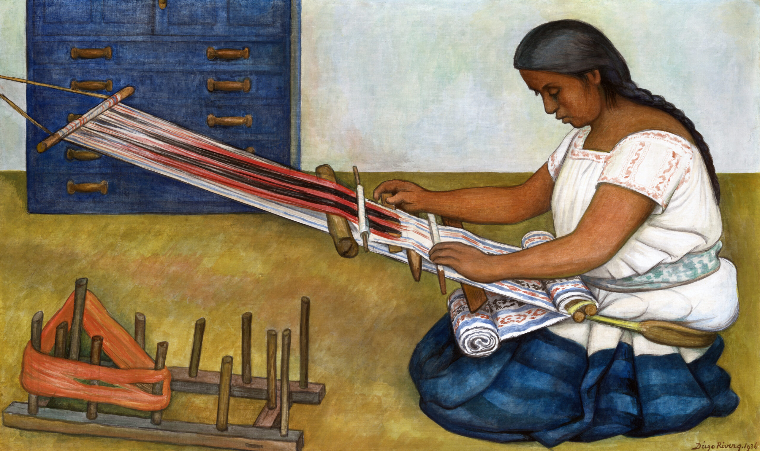
Weaving in Andean cultures was usually done on backstrap looms made from a series of sturdy sticks supporting the warp, or skeletal threads, of the textile. A backstrap loom is tied to a post or tree at one end, while the other end is attached to a strap that passes around the back of the weaver. By leaning forward or tilting back, the weaver can adjust the tension on the warp threads as he or she passes the weft threads back and forth, creating the pattern that we see on the surface of the textile. By the time of the Inka, an incredible number of variations on this basic technique had created all kinds of textile patterns and weaves.
T’oqapu (detail), All-T’oqapu Tunic, Inka, 1450–1540 (Inka), camelid fiber and cotton, 90.2 x 77.15 cm (Dumbarton Oaks, Washington, D.C.)
The two main fibers spun into the threads of the tunic came from cotton and camelids. Cotton plants grew well on the Andean coast in a variety of natural colors. Camelids thrived in the highlands (this includes the wild guanacos and vicuña and their domesticated brethren, the llama and the alpaca). Most Andean camelid-fiber textiles were made with the silky wool of the alpaca. Animal fibers are more easily dyed than plant fibers, so when weavers wanted bright colors they most commonly used alpaca wool. The All-T’oqapu Tunic is made of dyed camelid wool warp over a cotton weft, a common combination for high-status textiles.
Collecting, spinning, and dyeing the fibers for a textile represented a huge amount of work from numerous people before a weaver even began their task. Some dyes, like cochineal red or indigo blue, were especially prized and reserved for high-status textiles. Cochineal dye comes from the bodies of small insects that live on cacti, and it takes thousands of them to make a small amount of dye. Indigo dyeing requires a high level of technical skill and a large investment in time. Red- and blue-dyed textiles were not only beautiful, they also represented the apex of the resources needed to produce them and the social and political power that commanded those resources.
T’oqapu (detail), All-T’oqapu Tunic, Inka, 1450–1540 (Inka), camelid fiber and cotton, 90.2 x 77.15 cm (Dumbarton Oaks, Washington, D.C.)
In the Inka empire, textiles were produced by a number of groups, but the finest cloth, called qompi in Quechua (the language of the Inkas), was produced by acllas (“chosen women”), women who were collected from across the empire and cloistered in buildings to weave fine cloth. The acllas also performed religious rituals and made and served chicha (corn beer) at state feasts. These women spun, dyed, and wove fibers that were collected as part of the Inka taxation system. The textiles they produced were then given as royal gifts, worn by the royal household, or burned as a precious sacrifice to the sun god, Inti. The threads in the All-T’oqapu Tunic were spun so finely that there are approximately 100 threads per centimeter, making for a light, strong weave. It was traditional to weave garments in a single piece if possible, as cutting the cloth once it was off the loom would destroy its spirit existence (camac), which formed as it grew on the loom. The All-T’oqapu Tunic is a single piece of cloth, woven with a slit in the center for the head to pass through, and folded over and sewn together along the sides with spaces left open as arm holes.
Iconography
The decoration of the tunic is where its name derives from. T’oqapu are the square geometric motifs that make up the entirety of this tunic. These designs were only allowed to be worn by those of high rank in Inka society. Normally, an Inka tunic with t’oqapu on it would have a band or bands of the motif near the neck or at the waist. Individual t’oqapu designs appear to have been related to various peoples, places, and social roles within the Inka empire. Covering a single tunic with a large variety of t’oqapu, as seen in this example, likely makes it a royal tunic, and symbolizes the power of the Inka ruler (the Sapa Inka). The Sapa Inka’s power is manifest in the tunic in several ways. Firstly, its fine thread, expert weave, and bright colors signify his ability to command the taxation of the empire, access to luxury goods like rare and difficult dyes, and the weaving expertise of the acllas. Secondly, among the t’oqapu in the tunic is one pattern than contains a black and white checkerboard. This was the tunic pattern worn by the Inka army, and shows the Sapa Inka’s military might. Lastly, the collection of many patterns shows that the Sapa Inka (which means “unique Inka” in Quechua) was a special individual who held claim to all t’oqapu and therefore all the peoples and places of his empire. It is a statement of absolute dominion over the land, its people, and its resources, manifested in an item that is typically Andean in its material and manufacture.
It is thought that these tunics were made for soldiers and the checkered pattern camouflaged them into an indistinguishable mass.
Checkerboard tunics, Inka, camelid fiber, first tunic: c. 1400–1540, 88.3 x 80 cm (Dallas Museum of Art), second tunic: 16th century, 87 x 76.5 cm (The Metropolitan Museum of Art), both in the Golden Kingdoms exhibition at The Metropolitan Museum of Art